 |
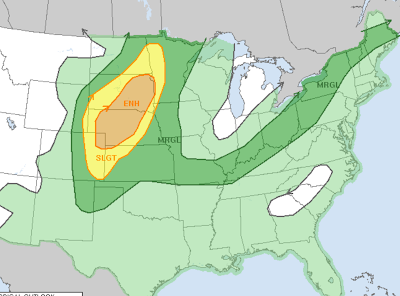
| Dark green areas on this map, including here in Vermont have a low but not zero chance of severe thunderstorms today. That yellow and orange are in the central Plains has a higher risk of bad storms. |
The stereotypical clean, cool, refreshing air is gone for now, replaced by something much more tropical. Summers in recent years have gotten hotter and more humid in the Green Mountain State. We're living that tropical dream now, it seems.
At least we still occasionally get cool, sunny breaks, like we did last Friday.
But not this week.
Burlington on Sunday tied the record first set in 1897 for the highest low temperature for the date. It never got cooler than 74 degrees yesterday. The high in Burlington Sunday got up to 92 degrees, already the fifth time this year it's gotten to or past 90 degrees.
We could make it to 90 degrees again today.
TODAY
It was quite oppressive overnight into this morning, too. Burlington never got cooler than 77 degrees last night and early this morning.
That warm start to the day sets the stage for a hot one, much like Sunday. Except with a somewhat greater coverage of showers and thunderstorms. Especially north. And later in the day.
As of 10 a.m.,this morning, there were lots of showers west and north of Montreal. Environment Canada had already issued a rainfall warning for possible local floods north of Montreal and a severe thunderstorm watch south of Montreal as of midmorning today.
The Canadian showers were mostly heading east, and not so much south this morning, which is a symptom of how slowly a lame but wet cold front up in Quebec is staggering southward.
Its slow movement suggests that most of the showers and thunderstorm probably won't break out until late this afternoon. We might see a few rogue ones earlier this afternoon. But most of the activity will come later, I think.There's a good chance most of them won't get too far south of Route 2 before evening.
The late arrival of most storms will enable most of Vermont to reach well into the 80s to maybe near 90 degrees. Those 90 degree readings are most likely in the central and southern Champlain Valley, where a heat advisory is still in effect today. Some 90s will probably pop up in the lower Connecticut River Valley, too.
That the storms will start to come in mid-afternoon or later, that'll give some of them time to work with the hot, humid air to turn into real gulllywashers.
NOAA's Storm Prediction Center has Vermont north of about Route 4 north in a low level marginal risk zone for severe thunderstorms. That means there could be isolated instances of damaging winds with one or two of the storms.
Additionally, NOAA's Weather Prediction Center has all but the extreme southeast corner of Vermont in a low level risk zone for isolated instances of flash flooding today.
That makes sense, since the storms that will develop later today have lots of moisture to work with, so they'll have torrential downpours.
The storms that do get going should move along at a pretty good clip, so torrential downpours from each individual storm won't last all that long in any particular place.
That's great if you get hit by just one thunderstorms. Your storm won't hang around in your backyard long enough to flood it out.
The problem is that damn slow moving cold front. It could set up a situation in which one thunderstorm after another moves roughly west to east just south of the front as it comes toward us.
This type of "line of boxcars" thunderstorms with repeated downpours could create a local flash flood threat.
I'll emphasize this isn't set in stone, it's just a possibility to watch for late this afternoon and this evening.
Given the slow nature of the front, showers and thunderstorms could last well into the evening, though they'll diminish in intensity as the sun sets. The sun's disappearance will reduce instability, which will sap the strength of any storms still wandering through the Green Mountain State.
Not everyone will see a storm today. As always they'll be hit and miss, no matter where you are in Vermont. Many if not most places south of Route 4 might not see anything at all.
LOOKING AHEAD
That sad excuse of a cold front will still be lingering around southern Vermont tomorrow, setting off a risk of storms there. I'm insulting the front like I am because it's not a powerhouse. It's mostly just a wind shift and a cloud generator.
Yes, it will be noticeably cooler Tuesday, especially north, where highs might not get out of the upper 70s. But it will stay kind of humid, as there's no big push of fresh Canadian air coming in behind this thing.
Showers and a few storms are most likely across southern Vermont with that front nearby.
The pathetic remnants of the "cold front" should move south of the region Wednesday giving us a bit of a break. But rather humid, and rather warm weather with an ever-present chance of showers and storms will probably continue into the weekend. Much of that time should stay rain-free though.
At least the operating word here is warm, not hot. Daily highs Wednesday through Sunday should mostly make it into the low and mid 80s.

No comments:
Post a Comment