 |
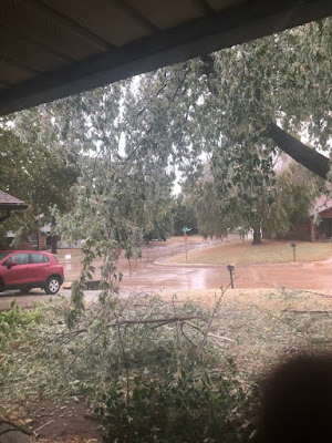
| Trees are beginning to collapse in an unprecedented early season Oklahoma ice storm today. Photo via Twitter by Jason Chandler |
Back then, New England was battered by the "Perfect Storm," the Midwest had an unprecedented early season cold snap and blizzard, and the Oakland Hills in California burned, killing 25 people and destroying thousands of homes.
Last week, I said this episode wouldn't be as wild as 1991. It turns out, though, that this weather pattern is close to being as off the rails as 1991.
The only thing missing this time is the Perfect Storm. A weak system is dropping light rain and a little snow on New England. But things could get quite interesting along parts of the East Coast later this week, more on that in a moment.
Let's go with the immediate headlines first.
There's a big ice storm going on in Oklahoma now. They happen from time to time there in the winter, but October? That's totally unprecedented. And even more dangerous and destructive than most ice storms.
That's because leaves are still on the trees there. A half inch of ice, which is predicted, is more than enough to break leafless trees and by extension power lines. With leaves on the trees, the destruction will be terrible.
Snowstorms with leafed out trees are very destructive, but some of the snow slides off, mitigating a little bit of the trouble. Not with ice. People throughout central Oklahoma, including the Oklahoma City metro area can expect long lasting power failures.
The temperatures supporting this ice are ridiculously colder than normal. The normal high temperature in Oklahoma City this time of year is around 70 degrees. It'll be in the low 30s this afternoon.
The extreme temperatures are widespread. Stockton, in southwestern Texas was 94 degrees Sunday afternoon. Today, it will be in the mid-30s. The entire Texas Panhandle and surrounding areas of the state are under a winter storm warning for freezing rain and snow.
 |
| A goofy screen shot as ABC Meteorologist Ginger Zee reports on record early season cold in Montana. |
Way north, in Rapid City, South Dakota, normal high temperatures are in the upper 50s. Sunday, the maximum temperature there was 17 degrees, or an incredible 41 degrees below normal. Today will be the firth consecutive day in Rapid City that failed to rise above freezing.
In Potomac, Montana, the temperature was a whopping 29 degrees below zero Sunday morning, the coldest for so early in the season anywhere in the United States outside Alaska. Missoula, Montana, reached 7 below, the earliest sub-zero reading in that city - by a full 7 degrees! Cheyenne, Wyoming got down to 1 above the coldest for so early in the season
WILDFIRE DANGERS
California managed to get through a dangerous weather day Sunday without any major wildfires, but I suspect the same won't be true today. This cold wave in the Rockies and Plains is also causing a similar weather situation to that in California during the 1991 Oakland Hills fire I mentioned.
As of noon, satellite imagery was spotting new fires in California. Blazes were breaking out near Irvine, where evacuation orders were in effect as of late morning. Other fires were in the Sierra Nevada east of Lake Tahoe, near Redding and in other areas.
Strong, dry Diablo winds continue to blow in northern California today and even stronger Santa Ana winds are blasting southern areas of the state.
Even without fires, the wind will be strong enough to cause damage to trees, power lines and even structures. Protected valleys in the Los Angeles Basin could still gust to 50 mph. Mountains and canyons can expect gusts in the 60 to 80 mph.
Imagine what would happen in those conditions if new fires start. Here's what the National Weather Service office in Los Angeles had to say about the situation:
"A particularly dangerous situation is expected for the Los Angeles County mountains Monday afternoon and evening due to the unusual combination of damaging wind gusts of 60 to 75 mph, single digit humidities and extremely dry vegetation. New fire ignitions will have the potential for very rapid fire growth, extreme fire behavior and long range spotting, resulting in a significant threat to life and property"
Sounds lovely.
TROPICAL STORM ZETA
Zeta is still chugging along in the western Caribbean Sea. It'll clip Mexico's Yucatan Peninsula and then make a beeline for the central United States Gulf Coast. It looks like Louisiana is under the gun again, for the fifth time this year
Current forecasts have Zeta at possibly Category 1 status as it reaches the coast, which is enough to cause more damage from storm surges, flooding and high winds.
Once it moves inland, Zeta will merge with the storm that's currently causing the freezing rain in Oklahoma, and turn into a big rain maker in the lower Ohio Valley and parts of the Southeast, where flooding is possible.
If moisture from this thing makes it far enough north, an early season snowstorm is possible in parts of New England Thursday night or Friday. It's still too soon to say for sure whether it will snow in New England not to mention how much and where.
This does have the potential to make things pretty interesting, though.

No comments:
Post a Comment