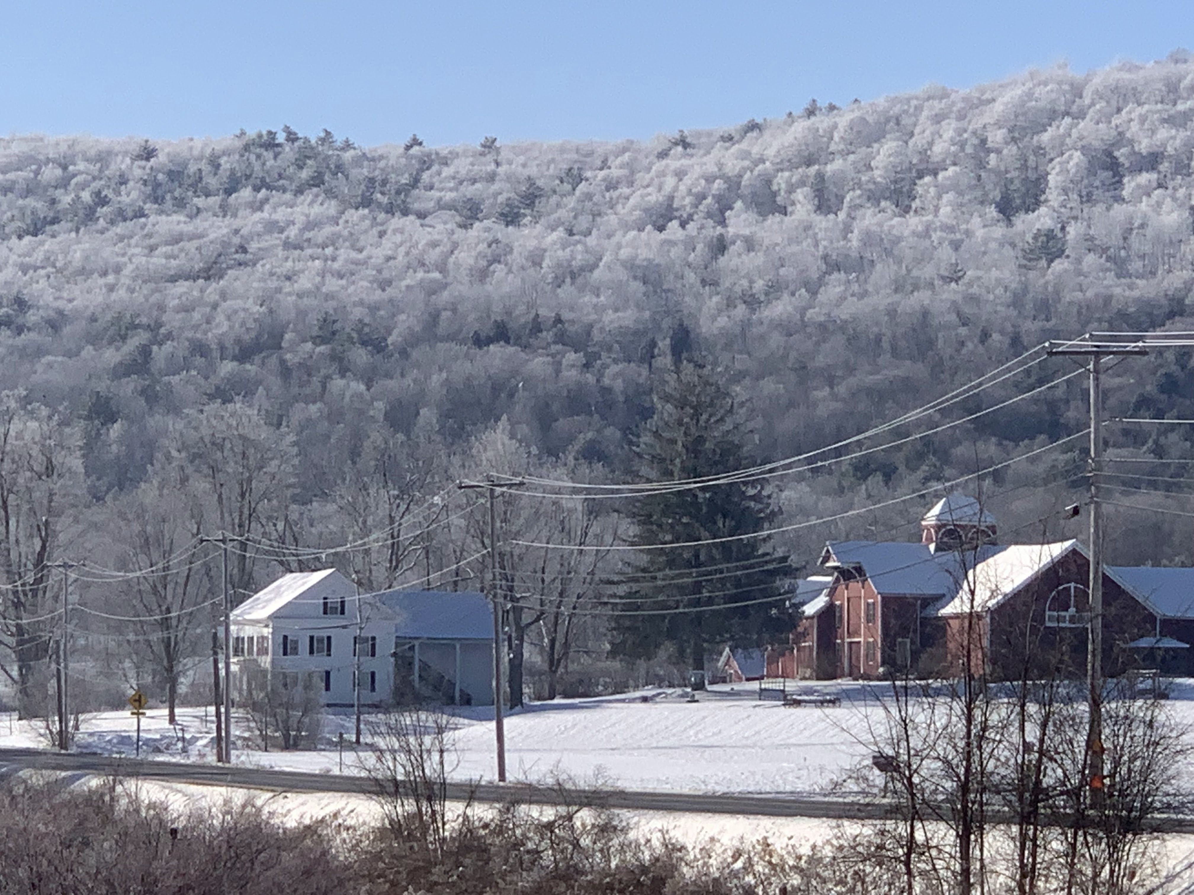
Once again, 2024 brought Vermont an eventful, often destructive and painful weather year.
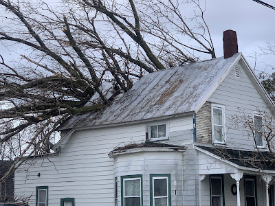 |
High winds on January 10 toppled a large tree, which
crashed through this St. Albans, Vermont home. |
It will be among the warmest years on record again, much like several previous recent years. More on that in a post coming along right around New Year's Day.
The weather extremes of 2024 were all over the place, from wind to floods to drought to heat to cold. Though not that much cold. The weather often turned destructive, sometimes tragic.
Weather in Vermont has never been boring. But nowadays, probably because we're in the age of climate change, things are getting even further out of whack.
Lots of extremes happened in 2024, so let's get into it:
TWIN WINDS, JANUARY 10 AND 13
Two intense wind storms swept the Northeast including Vermont in mid-January.
The first of the two hit on January 10.
Winds gusted to 69 mph at the National Weather Service office in South Burlington, their fourth highest wind gust on record. Power was cut to 29,000 homes and businesses.
St. Albans was particularly hard hit, with at least three home virtually destroyed by falling trees, with several other houses suffering some damage.
Along the New Hampshire and Maine coasts, the storm and wind generated a huge and in some case record storm surges which caused massive damage. A new storm a couple day later made everything there even worse
That second storm hit on January 13, especially along the western slopes of the Green Mountains, where winds topped 80 mph in some spots. The wind blew the roof off a house in Richmond, and fallen trees again blocked numerous roads. Power outages in Vermont again reached a peak of about 29,000 customers.
FEBRUARY
Another warm winter month. Record warmth on February 9-10 and 27-28 contributed to an average February temperature of 30.2, the third warmest on record. The high temperature of 65 degrees on February 28 would have been the hottest on record in Burlington if not for recent, even bigger February hot spells in 2017 and 2018.
BIG APRIL 3-5 SNOWSTORM
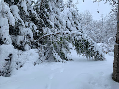 |
Damaged trees after 16 inches of wet, heavy snow
fell on St. Albans, Vermont in early April. |
One of the biggest
April snowstorms on record blanketed the entire state. Biggest snow totals included 24 inches in Moretown in Killington, 21 inches in Underhill and Eden, and 20 inches at Brookfield and Stowe.
Burlington had 10 inches of snow on April 4, its third snowiest April day on record.
The snow was wet and heavy, causing widespread tree damage and power outages.
VERMONT ECLIPSE GOOD LUCK
Northern Vermont was in the direct path of the Big Solar Eclipse Of 2024. It was widely expected that few of us would see it, as on average we'd have an 80 percent of overcast skies that time of year.
Instead, the Green Mountain State was blessed with fair skies. There was a broken layer of very thin, high clouds, but that augmented the experience by adding some odd sunset style colors to the sky during the big event.
We had a second episode of celestial good luck when one of the biggest, brightest most extensive northern lights display graced much of the northern hemisphere as far south as Cuba on the night of May 10.
Though skies had been forecast to be mostly cloudy, most of the night ended up mostly clear in Vermont, allowing for great viewing of the rare event.
JUNE 18-20 HEAT, STORMS
Brief but intense heat wave, accompanied by severe thunderstorms in some areas. North Springfield had daily highs during the period of 98, 99 and 101. Union Village Dam in southeastern Vermont had 100 degree highs on two consecutive days.
 |
Flash flooding in South Burlington, Vermont following
intense storms on June 23. Some of the storms
prompted tornado warnings, but none were known
to have touched down in Vermont. |
Burlington reached 96 degrees on June 19. The low temperature that day in Burlington was 80 degrees, tying the record for the warmest overnight low of any day in more than 120 years of records.
The heat was accompanied by strong storms in some parts of Vermont. After reaching 93 degrees on June 20, Burlington had about an inch of rain within 15 minutes with a storm wind gust of 48 mph.
Trees came down in Burlington and Stowe, as a precursor to even bigger storms a few days later.
JUNE 23 TORNADO ALERTS AND FLASH FLOOD
A stalled warm front just to the north and an incoming cold front, combined with very humid air set the stage for a severe weather outbreak on June 23. Forecasters had called for a risk of tornadoes, and in fact a handful of tornado warnings were issued in Vermont as radar showed notable rotation.
Wall clouds and possible funnels were reported, especially near Monkton, but no tornadoes are known to have touched down. There was some tree and power line damage from winds, but that damage appears to have been caused by straight-line winds.
However, the supercell thunderstorms contained intense downpours, and the two strongest followed roughly the same path across north-central Vermont. The result was flash flooding, the worst of which hit around Stowe and areas around the Worcester Range. Washington County was subsequent declared a federal disaster area due to the flash flood damage.
This flash flood was just a foretaste of what was to come.
JULY 10 FLOOD DISASTER
Another stalled warm front, and the remnants of Hurricane Beryl caused a new extreme flash flood disaster on the exact anniversary of a similar calamity that hit exactly a year earlier.
 |
A tractor fell into the ravine created by this road
washout near Hinesburg, Vermont on July 10. |
Unlike the 2023 flash flood, which hit most of Vermont, the July 10, 2024 was mostly focused on northern and central Vermont. Rainfall totals were as high as nearly seven inches in Hinesburg.
Two deaths were reported in the storm, one in Lyndonville and the other the Peacham.
This disaster re-flooded homes and businesses damaged in the flood the previous year. Hundreds of roads and bridges suffered significant damage, and as of the end of this year, not all the repairs had been completed yet.
Some of the more dramatic incidents during this disaster included an apartment building that was mostly swept away in Plainfield. The building's occupants evacuated shortly before the the structure collapsed.
To nobody's surprise, large swaths of Vermont were declared disaster areas.
The disaster was preceded and followed by oppressive hot, humid weather, which slowed post-disaster cleanup. Lebanon, New Hampshire had a record 12 consecutive days in the 90s from July 6-7. It was Burlington's third hottest July on record.
EXTRME NEK FLASH FLOOD JULY 30.
Early morning thunderstorms on July 30 dumped an incredible amount of rain in just a few hours in large parts of the Northeast Kingdom. St. Johnsbury received eight inches of rain in just four hours, which is the amount of rain that normally falls there in the summer over the course of two months.
The resulting flash flood washed away houses in Lyndonville and other towns, but miraculously no deaths were reported.
But there were close misses. One woman was rescued by neighbors after her house fell into a raging river with her inside it. Two elderly women, one age 98, and their dog, were pulled through their bedroom window by neighbors after their home floated onto a road and thankfully got stuck there instead of washing away and completely disintegrating.
The storm was highly localized. The eastern end of the town of Danville had 7.4 inches of rain. Another location in the western part of the same town just six miles away received just under an inch of rain.
A weak upper level low pressure system drifted northwestward into New England and stalled for a time over the Northeast Kingdom, causing the extreme downpours.
DEBBY REMNANTS CAUSE WIND DAMAGE
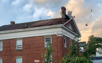 |
High winds associated with former Hurricane Debby blew
the roof off this building in St. Albans Bay, Vermont. |
The remnants of
Hurricane Debby swept over Vermont on August 9, causing a surprisingly strong wind storm that evening. Burlington gusted to 62 mph.
In Alburgh, a large falling tree crushed a house, trapping a resident inside who was later rescued. The roof blew off a house in St. Albans Bay.
Numerous roads across Vermont, especially the Champlain Valley, were blocked by fallen trees and power lines. At one point, 49,000 Vermont homes and businesses were without power.
LATE OCTOBER/EARLY NOVEMBER HEAT
Summer seemingly did not want to quit in the last ten days of October and the opening week of November..
Burlington tied or broke four record highs from October 21 to 31, including a reading of 77 degrees on Halloween. That was the warmest for so late in the season. Plattsburgh soared to an unbelievable 83 degrees on October 31. Woodstock reached 80 degrees.
The late autumn heat had a final resurgence on November 6 as temperatures climbed to 75 at Union Village Dam, Woodstock and Bennington
FLASH AUTUMN DROUGHT, FIRES
On October 8, no areas of Vermont were in drought. Just eight weeks later, 70 percent of the Green Mountain State was deemed to be enduring drought conditions.
The drought created a slew of unusual autumn forest and brush fires across the Northeast, including here in Vermont. The Green Mountain State had its worst fire year since at least 2016, thanks to autumn brush fires. One of the fires burned through 70 acres near Barnard.
HOT YEAR ENDS ON HOT NOTE
2024 will be the world's hottest year, and the hottest year on record here in Vermont. The year came to a fitting end with a record heat wave on December 29-30. The temperature reached 61 in Burlington on December 29 and 60 on December 30, both record highs for the date.