Vermont weather geek's hodgepodge of weather and climate news and opinion. Often Vermont focused, but taking a national and global approach, with sometimes an appropriate dash of fun, outrage, cynicism and compassion.
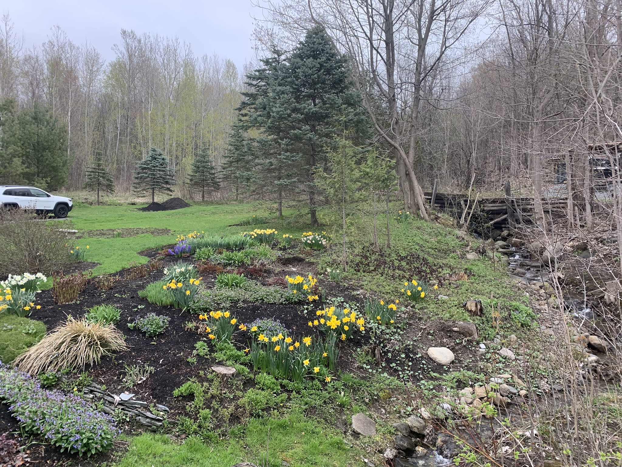
With the recent damp, mild weather, garden flowers in St. Albans have recovered nicely from a snowstorm nine days ago, and the forest out back is slowly getting greener. Unfortunately, a few snowflakes possible late tonight, but not enough to set anything back.
UPDATE: MORE SPRING SNOW!
It looks like we have another over-performing spring snow event on our hands in northern New York and Vermont.
I know, I know, but at least it won't be nearly as bad as last time.
As of 6 p.m. a big shove of cold air had changed rain to snow in northern New York. Temperatures were also rapidly falling, or just about to in Vermont.
Moderate snow was reported at Saranac Lake and Massena, New York as of 6 p.m. The snow was heading east.
That means many of us will have snow on the ground once again later tonight and tomorrow morning.
For such a mild spring, it's also been a snowy one.
Even the Champlain Valley should have a slushy coating to an inch of snow by morning. Many elevations above 1,000 feet in Vermont should get at least an inch of snow, if not a little more. Above 2,000 feet, we're talking two, three or more inches of snow.
Tomorrow is May 1, so yes, we're talking about snow on the ground in May.
The main thing that will save us from getting more snow is the precipitation will become more and more oriented toward being over the mountains and less so in the valleys as the night wears on. Also, Vermont will probably get less snow than northern New York, the way trends look now.
Still snow showers will remain widespread Saturday morning before slowly drying up and turning to sprinkles, then ending as the day wears on.
Believe it or not, the next disturbance late Saturday night might also bring a little snow, mixed with the rain. That won't amount to anything, though.
PREVIOUS DISCUSSION
Before you get too alarmed by the headline in this post, the snow we'll talk about will be mostly in the high elevations and won't exactly be a blizzard.
Let's get that out of the way first.
Even so, today - Friday - won't exactly be the best one for your outdoor plans. It'll rain most of the day, especially in the northern half of Vermont, and I think we've already seen the warmest temperatures of the day.
At dawn today it was mild and drenching with a steady, soaking rain once again. The day was off to a pretty mild start, too, with temperatures across the Green Mountain State right around 50 degrees.
The damp, mildish weather of the past couple of days has really pushed the spring greening process out there, which is nice.
So, of course, later today, tonight and first thing in the morning will be yet another slap in the face. Just not as hard a slap as we've seen with wintry events earlier this month.
Temperatures will slowly fall into and through the 40s this afternoon as west and northwest winds pick up. A strengthening storm near the New England coast this morning is to blame for that. As it pulls off to the northeast, it will get even stronger.
The pressure difference between that and high pressure over the western Great Lakes is to blame for that.
By tonight, it will be downright blustery and cold with continued showers, especially in the mountains. These northwest winds will affect most of the East Coast, where wind advisories are up for a large area from New England to North Carolina.
Here in Vermont, snow will break out on the summits this evening and work their way down the slopes. The National Weather Service in South Burlington is thinking one to three inches of accumulation above 2,000 feet, which is fine since not that many of us live up that high.
But a possible slushy coating of snow down as low as 500 feet in elevation could give us an unwelcome reminder of winter. Snowflakes early Saturday will probably reach valley floors in much of Vermont. I wouldn't be surprised to see the flakes fly down in Burlington for awhile. Even parts of southern New England away from the coast are in for a little snow
Don't worry, though, this won't be another daffodil destroyer. Outdoor plants, except the ones that should't be out yet anyway, will be just fine.
Saturday's weather should improve as the day goes on, but it will stay chilly for the season. (Highs near 50 instead of the normal low 60s).
Another disturbance will have our Sunday begin showery, but improve later in the day. Showery weather will persist early next week, with drying after that. Temperatures will be just slightly cooler than average, but nothing weird for early May.
"The library complex houses UCT's Special Collections, which hold irreplaceable artifacts, including annotated watercolors of plant and animals dated from 1881, painted by Indigenous inhabitants of the Cape. It also holds maps, manuscripts, and government records from the Cape's mottled past - including its colonial and military history."
Other dangerous wildfires broke out in recent days in Arizona, and in of all places, Northern Ireland.
The South African fire was easily the worst, and demonstrates how wildfires can have devastating effects in ways that surprise and crush the spirit.
The fire gutted the University of Cape Town African Studies Library, home to a collection of African history.
The usual suspects are to blame for this terrible wildfire. While officials haven't pinned down the exact source of the fire, it's widely believed to have been started by humans, as are most wildfires.
Perhaps it was somebody cooking in the woods, and the fire got out of hand. An arsonist was arrested, but at last report it's unclear if that person was responsible for the conflagration.
The fire took off due to unusually hot, dry and windy weather. A specific hot spell like the one that hit Cape Town at the time of the fire cannot be readily attributed to climate change. But weather like that becomes more likely in a warming world.
According to Nature, researchers have put up an online page asking anyone with photos or digital scans of the library's collections to upload them.
"''This archive is special for all sorts of reasons, and for me it's because it includes collections which provide a record of the ordinary lives of ordinary people in the area - from working-class children to Black students attending night school, says Sarah Emily Duff, a historian of South Africa based at Colby College in Waterville, Maine. 'We lose that texture of everyday life and struggles with a catastrophe like this,' she added."
If this fire was brought on by climate change, there's a little irony in the damage to University:
"The university's botany building was also seriously damaged. In the Plant Conservation Unit, where researchers track changes in studying fossilized pollen and comparing historical photos with current day images, the damage is total, says the unit's leader, Timm Hoffman a historical ecologist."
Some student housing and a restaurant also burned down in the fire.
A hole in a home's ceiling west of San Antonio, Texas. Hail was big enough to punch through the roof of the building and into the living room. Photo via Twitter @vortexrfd
Hail the size of baseballs or even bigger slammed parts of three good sized metropolitan areas last night, surely creating a very expensive disaster.
The areas hit were the San Antonio, Texas area; Dallas-Fort Worth - especially the northern suburbs; and Oklahoma City, especially its southern suburbs around Norman.
One person suffered a head injury near Norman as a result of the hail, the NOAA's Storm Prediction Center noted in its daily storm summary.
Since the hail was widespread and hit populated areas, this could well be yet another $1 billion plus disaster.
Hurricanes and tornadoes get all the dazzling news coverage, but hail is often the most expensive kind of weather in the United States. Insurance claims for hail damage routinely pile up to around $10 billion annually.
Huge numbers of cars, windows, roofs. skylights, siding and landscaping in the three metro areas affected by the supercell thunderstorms were damaged and destroyed. Insurance adjusters are going to be incredibly busy.
In some cases, giant hail pierced through roofs. Social media photos from Sabinal, Texas, west of San Antonio showed holes in a home's ceiling wherehail bigger than softballs crashed through the roof, attic and into the living room.
Another image showed a Texas Honda dealership with broken windshields on all the cars on the lot.
Photos from Norman, Oklahoma show the effects of baseball-sized wind-driven hail. Windows were shattered and window shades were shredded.
Large hail driven by high winds, shredded this window and window shade in Normam, Oklahoma last night. Photo via Twitter by @marekcornett
Near Fort Worth, one person with a sense of humor, demonstrating the size of the hail, took a photo of a cinnamon bun next to a similarly sized hailstone.
A few tornadoes were reported with some of the hail-producing supercells, but those twisters seemed to hit more remote areas and caused relatively little damage.
Today, severe storms are a good possibility, mostly in a band from northern Mississippi up the Appalachian chain as far north as the northern suburbs of New York City.
Weather patterns remain favorable for more severe weather over the weekend and next week over swaths of the South and Midwest.
VERMONT RAIN
The Green Mountain State won't see any hail anytime soon, but we're finally getting quite a bit of needed rain.
Yesterday's showers produced roughly a third to a half inch of rain, with locally higher amounts. Another good slug of rain should come through later today and tonight with an additional half inch to an inch of rain
Showers tomorrow will add a bit to the total, and more weather disturbances next week could deposit even more precipitation.
Some favored high elevation places in Vermont could see a total of up to three inches of rain over the next seven days. Most of us will probably see well over an inch in that time period. Which is great news with the current low water tables and rainfall deficit that stubbornly lingers.
The only trouble with this is there won't be any long periods in which we can get outside in nice weather, but we'll take it.
Another problem is that dreaded "S" word. It'll get cold enough for some snow Friday night, mostly at elevations above 1,500 feet, but a few snowflakes could make it down lower in elevation than that. Some mountain peaks could get several inches of snow out of this.
It won't be nearly as bad as the snowstorm that hit Vermont last week, though.
Today, we bring you relatively good news about tornadoes: This month in the United States, there hasn't been all that many of 'em.
Up here in Vermont, we still need rain. And we're going to get it. More further down in the post. But first, tornadoes!
QUIET TORNADO APRIL
As Bob Henson notes on Twitter, through this past Monday, only 51 tornadoes had been noted in the United States this month.
On average, there are usually between 150 to 200 tornadoes in April.
There were as many as a dozen tornadoes yesterday in Texas, Colorado and Oklahoma. There will likely be a few more twisters today. But there almost certainly won't be any big tornado outbreaks before April closes out Friday. We might end April with fewer than 100 tornadoes, only the fourth time that's happened since 1990.
Several influxes of cool, dry air from Canada into the Midwest and South have squelched tornado activity this month. One crucial ingredient for tornado outbreaks are surges of warm, very humid air from the Gulf of Mexico into the heart of the country. That has generally been lacking this month.
Overall, 2021 has been a relatively slow year for tornadoes, at least so far. Through Monday, there had been 269 tornadoes in the United States. Through the month of April, we usually have about 300 tornadoes.
March was a relatively busy month, compared to average. There were 191 tornadoes in the U.S. in March, 2021 including one oddly here in Vermont.
Long range forecasters had noted earlier this year that large scale weather patterns this spring would have some similarities to that of 2011. That prompted predictions of a busy, dangerous spring and early summer tornado season of 2021.
That still might happen, of course. May and early June are the peak months for U.S. tornadoes. The average number of U.S. tornadoes in May increases hugely to 276. In June, the average number is 243.
We definitely have a long way to go with this year's tornado season. At least we're off to a good start.
Sadly, ten people have died in tornadoes so far this year. Still, that's not bad compared to some years, like 2011 when the death toll was in the hundreds.
The very strongest tornadoes, ones with a category of EF-5 with winds of over 200 mph, are obviously the most dangerous and deadly.
It's been a long time since the nation has seen of those monsters, too. As Andrew Siffert noted on Twitter, we've gone 2,900 days or about eight years without an EF-5 tornado. If we go another three weeks or so with no EF-5s, that would be the longest stretch on record. Fingers crossed!
VERMONT RAIN
I've been harping all year that we need rain to overcome a lingering drought in Vermont. It seems this spring the only we get needed moisture it comes as snow.
Perhaps a little hard to see here, but an indication that Vermont still needs rain. The other day I dug into a pile of soil I left last fall. A few inches down, it was still as dusty as it was when I piled it up. (dusty part is lighter brown/tan) We haven't had enough rain to percolate down.
So some good news for the rest of the week: We have a decent amount of rain coming. And unless you live in a high elevation, it'll be all rain, not snow. (And the high elevation snow won't amount to anything much).
Clusters of showers keep moving roughly west to east along a wavering weather front that is positioned mostly just to our south. One cluster clipped Vermont overnight with some rain central and south.
Other batches of showers are due this afternoon and evening, Thursday afternoon and evening and on Friday. Overall these showers could accumulate to an inch of rain or more by the time we roll into Saturday. Some places could get more than 1.5 inches.
That's not exactly torrential, given that the rain will come over three days or so. But it will help at least a little. We still need a few to several inches of rain to overcome a deficit we've accumulated since last year.
Massive tornado crossing a highway in Tuscaloosa, Alabama, April 27, 2011. One of 300+ tornadoes in this outbreak Today is the tenth anniversary of arguably the worst tornado outbreak in U.S. history.
People across the South, Midwest and East today are marking the tenth anniversary of arguably the worst tornado outbreak in United States history.
Since April 25-28, 2011, all other tornado swarms are measured against this epic outbreak, which peaked on April 27 that year.
A whopping 350 tornadoes or so touched down in the United States during this outbreak, the most in any swarm in history. Some videos of this incredible event are at the bottom of this post.
Meanwhile up here in Vermont, the same storm system spawned our own smaller, but still very significant disaster in the form of a destructive flash flood that also greatly contributed to a record flood crest on Lake Champlain. More on Vermont's issues that week further down in this post.
The tornado outbreak of 2011 easily outdid the previous record for a tornado outbreak in the United States, one that produced 148 tornadoes in April, 1974.
If you combined all the paths of the tornadoes in the 2011 outbreak into one continuous string, it would extend 3,200 miles. The part of the nation hit by tornadoes was immense, too, extending from central Texas to central New York.
The tornado outbreak was especially notable for the number of strong and extreme tornadoes in produced, especially in Alabama. That state suffered 240 of the tornado deaths attributed to the outbreak.
Fifteen of the tornadoes were rated EF-4 or EF-5, the strongest possible. It's rare to get as many as three or four tornadoes that strong in a single outbreak.
These strongest tornadoes also traveled great distances at high speeds, making them especially deadly. The Weather Channel says the average path length of the 15 strongest tornadoes was 65 miles, and they had a forward speed of between 45 and 70 mph.
Red dots depict all the tornado reports just on April 27, 2011 and don't include the reports on the previous two days and the day after.
As you can imagine, debris was scattered far and wide by this tornado swarm.
A photograph sucked up by an EF-5 tornado in Phil Campbell, Alabama was later found 220 miles away in Tennessee. A jacket picked up by a tornado in Hackleburg, Alabama was later found 68 miles away.
The most famous of the many tornadoes in this outbreak was a monster EF-4 that traveled an 80-mile long path through Tuscaloosa, Alabama through the northwestern suburbs of Birmingham, killing in total 65 people.
That is a very, very long track for a tornado. The parent tornadic supercell thunderstorm held together for an incredible 380 miles from southeastern Mississippi to western North Carolina.
The tornadoes were unrelenting, especially in and around Alabama, which suffered at least three rounds of destructive tornadoes. The town of Cordova, Alabama was struck by two strong EF3 tornadoes on April 27, 2011, one early in the morning and the other during the afternoon.
Today, the 10th anniversary of this disaster, is surely a somber day, especially in Alabama.
VERMONT IMPACTS
Vermont escaped the tornadoes of April, 2011, with the closest one touching down west of Albany. Instead, we got a destructive flood, one of several in that devastating year of 2011.
Snowpack in Vermont in the early spring of 2011 was at near record high levels, especially in the mountains. The month of April leading up to this event was very wet. There had already been one damaging flood a couple weeks before this event.
Even before the April 26-27 storm, Lake Champlain was well above flood stage.
Severe flooding along the Lamoille River near Cambridge, Vermont on April 27, 2011. Major damage from flooding in much of Vermont that day
The days leading up to this flood were also quite warm, which primed the pump by softening and melting all that mountain snow.
An initial round of showers and some thunderstorms associated with the storm and tornado outbreak came through Vermont early on April 25, sending rivers close to bank full.
Then, in the evening and overnight hours of April 26, repeated, heavy early season thunderstorms rolled over Vermont. Some were almost severe, which is odd for so early in the season. For instance, St. Albans was barraged by a lot of dime sized hail in one storm.
More importantly, these storms contained torrential downpours. Two to five inches of rain fell on northern and central Vermont, especially around the Lamoille River Valley. That evening and overnight, flash flooding from small creeks and streams roared out of the mountains and into northern Vermont towns.
A little stream by my house in St. Albans, normally a few inches deep at most, was suddenly five feet deep. It caused flash flood damage on my property via washouts and debris flows. I've never had anything close to a flash flood before or since that event.
The Lamoille River went into major flood, with one of the highest crests on record. Dozens of homes and businesses flooded, especially in Johnson and Jeffersonville. Northeast New York and northern Vermont were declared major disaster areas, as flood damage exceeded $9 million.
The water from this flooding inevitably flowed into Lake Champlain, forcing the lake into its highest crest on record, 103.2 feet on May 6, which of course created yet another multi-million dollar flood disaster.
ECHO WEATHER PATTERN
Interestingly, the weather pattern this week is vaguely similar to that of late April, 2011, but the ingredients certainly are NOT there for a repeat of that calamity ten years ago. A few tornadoes might spin up in the Plains and Midwest today and tomorrow. A brief twister could conceivably even touch down in western New York tomorrow.
But this week's rough weather will be a typical spring severe storm episode, and won't be especially noteworthy.
A nearly stalled weather front will also waver near Vermont this week, much as one did on April 26-27, 2011.
Very much unlike ten years ago, the weather front this week will produce only a moderate amount of rain. This rainfall will do far more good than harm, and won't lead to flooding. The expected rains later this week will help put a dent in Vermont's lingering drought.
Videos:
Terrifying television tornado coverage by legendary Alabama meteorologist James Spann as the giant tornado roared into Tuscaloosa:
An even scarier close up view of the Tuscaloosa tornado as it roars past an apartment:
Excellent overview of tornadoes/destruction in Alabama from ABC 33/40, which is Spann's television station:
Finally, a video I took of powerful floodwaters along the Lamoille River near Cambridge, Vermont on April 27, 2011.
It's ba-a-ack! A little dusting of snow on my St. Albans, Vermont deck this morning. Despite that bit of overnight moisture, strong winds and dry air will create a fire hazard today in Vermont/New England.
On Mondays, I like to set the tone for the week.
However, here in Vermont, there's no tone today, at least in the weather forecasting department. Expect a little of everything.
Showers yesterday and last evening didn't amount to all that much. It got abruptly colder overnight, and that four-letter "S" word made a reappearance.
here was a dusting of it on my decks early this morning before it quickly, mercifully melted away.
Despite the light showers and those flakes of snow, there's a fire weather hazard today, believe it or not.
Like I said, it didn't rain much, so what moisture there is will quickly disappear off last year's old, dead stuff out in the fields and forests. Despite the spring green up, last year's dry stuff is still there, noticeable and ready to catch fire given the right conditions. ,
Dry, gusty winds were already blowing as dawn broke today, and those winds were bringing in some arid air.
The combination of low humidity this afternoon - at or below 20 percent - and winds gusting as high as 35 mph will make the risk of hard to control brush fires pretty high this afternoon in much of New England.
There's ared flag warning in effect today for the southern half of New Hampshire and southwestern Maine. The warning is an alert for high fire risk.
The National Weather Service in South Burlington went with a special weather statementfor all of Vermont noting the worries about brush fires today. "If any fires were to start, the weather and fuel conditions could cause the fires to quickly get out of control and be difficult to contain," the special weather statement says.
Today is NOT the day to get rid of that brush pile in your yard with a fire. I doubt many town fire wardens would be issuing burn permits today, anyway.
Fire weather concerns will probably continue tomorrow, but at least it won't be as windy then.
Of course, we still need the rain and it looks like some is on the way later this week. How much rain is an open question.
The forecast for later in the week has changed from some of the ones I saw late last week. Rather than a strong ridge of high pressure giving us very warm and dry conditions, the ridge is weak and weather fronts will be draped over Vermont, or at least nearby Tuesday night into Friday.
Weather disturbances will be moving along and through these fronts, so the combination makes us ripe for showers. Timing and intensity of the showers is a big question mark. For now, expect just a general risk of on and off rain from midweek on.
It'll start off kind of mild Wednesday and Thursday, and then get nippy again by Friday and especially Saturday. Nothing bone chilling, but by Saturday, the expected high temperatures in the low 50s are about ten degrees cooler than average.
It's later in the spring now, so cool spells are losing their intensity, thank goodness. There's a huge difference between the beginning of April and the end of the month.
Pecos Hank doesn't take himself too seriously, and he's a great storyteller. Plus unlike in so many other storm and tornado chasing videos, the ones Pecos Hank gives us are not yell fests. The focus is on the storm, not the chaser.
Olbinski is a favorite of mine because he is such an artist. He pays the utmost attention to the details in his cinematography.
He's the best at capturing the grandeur of both the storms he captures and the landscape those storms affect.
We all expect a sharp crispness to Olbinski's photography, and that's precisely what you get and more. After all, when he's not chasing storms, he's an accomplished Arizona wedding and portrait photographer.His editing technique comes through expertly. He can make lemonade out of lemons
You can tell that some of the storms Olbinski encountered that he used in "Shadows In The Sky"had sub-optimal light and surroundings. You can't expect every storm to do the work for you.
But the photo editing made those problems disappear without compromising the reality of the storms. Nothing looks fake here. That he is Arizona based helps, too, as he captures some awesome desert microbursts and haboobs.
The music adds to the emotional mix of apprehension, awe, foreboding and excitement Olbinski's time lapses offer. And it builds to a surprisingly satisfying crescendo.
Weather geeks like myself of course will want to watch"Shadows In The Sky" repeatedly. I also encourage people who are not the least bit interested in the weather to check it out. If you like photography and art and fascinating video, this is the required viewing.
I feel sorry for people who never pay attention to the sky, the clouds, the heavens. Olbinski is creating converts to the happy club of people who are in awe of what nature can create when it is in a stormy mood.
As promised, we're back to full blown spring here in Vermont after our bout with late season winter.
For me, it was back to doing garden work yesterday here in St. Albans, Vermont on a cool, breezy, but pleasant evening. That involved assessing the damage from the snow and freeze. I found that plants can be nice and resilient.
A series of photos in this post depict our journey in St Albans from spring to winter and back to spring.
What saved many garden plants around much of Vermont was for most of us, temperatures stayed at or above 25 degrees.
It felt colder with the wind chill, but wind chill is for us humans. The snow hurt by crushing tender flowers and stems, but also helped by burying leaves and sprouts to protect them from the cold.
It's still not perfectly clear yet what died and what survived, but for most plants, they're good.
2:32 p.m. April 21, the burying begins.
The most disappointing result I've seen is that although all those daffodils around my house survived and continued to bloom, they got mushed down and are now not as pretty and well-arranged as they were.
Some flower stems failed under the weight of the snow, so the flowers drooped to the ground and are dying.
The forsythia flowers, a brilliant yellow before the storm, are now brown and dead, but the new leaves sprouting on that bush look fine. The leaves on the day lily plants are flattened but will perk up as spring progresses.
I'm cautiously optimistic about the lilacs. The budding flowers drooped and took on a darker, brownish color in the freeze, making me think they died and we'll have to wait another full year for the glory of the lilacs.
However, the flower buds seemed to perk up in Friday's sunshine, so maybe they survived. We'll see how they do in the next few weeks.
4:31 p.m April 21 The snow keeps flying
Thank goodness we don't have much more cold weather to talk about. Today will be sort of warm for the season with highs up into the 60s.
Sunday will bring less rain than originally expected, but there will be showers around under seasonably cool conditions.
The dreaded "S" word comes back late Sunday night and early Monday, but relax, it will be no big deal. There might be a few wet snow flakes in the air in the hours either side of dawn Monday, but it won't amount to anything.
Monday will be close to 10 degrees colder than average, but that means highs will be near 50 degrees. That's not too bad. Temperatures will be near freezing Monday night, but again, not cold enough to cause any further plant damage.
The weather for the rest of the upcoming week looks fairly uncertain, but it will be a little warmer than average, and expect some late April showers here and there.
Continue to scroll down to see our climb out of the winter blast and back into spring. It's satisfying to see.
8:54 a.m. April 22. The depths of winter. Temperatures were around 27 degrees when this photo was taken.
7:31 p.m. April 22. The snow hung on stubbornly all day but do the warm colors of that sunset portend better times ahead?
7:13 a.m Friday, April 23. It feels a bit warmer and look at that blue sky headed our way. Hope?
9:56 a.m. Friday, April 23. The sun begins to do its work
12:25 p.m. April 23. Almost there!
2:32 p.m. April 23 The daffodils are looking a little battered, but back to full on spring!
A truck collects maple sap gathered in St. Albans, Vermont this past March 21. The sugaring season was lackluster due mostly to early bouts of unseasonably warm weather.
The recent bout of winter weather in Vermont notwithstanding, a very warm, very early spring really screwed up our all-important maple sugaring season.
A much-too-premature bout of 70 degree weather in March plus low sugar content in the maple sap are to blame for the lackluster yield.
Vermont's maple sugar harvest usually runs from late February into April. Record warmth from March 23 to 26 brought a premature ending to season, especially for producers in the warmer valleys of the Green Mountain State.
In northeastern Vermont and in some higher elevations, where the sugaring season often lasts well into April, a long spell of more record and near record warmth between April 8 and 14 put the kibosh on the season.
Though yields were down this year, it doesn't look like there will be a maple supply shortage. The Vermont Maple Sugar Makers' Association says one off year won't mess up supplies. If we have several bad years in a row, then it becomes a problem.
Vermont is by far the nation's leading maple producer. We normally produce about 2 million gallons of syrup, which makes up more than half of all U.S. production.
Climate change is disrupting and altering Vermont's famed sugaring season. The Proctor Maple Research Center says sugaring season starts 8.3 days earlier and ends 11.6 days earlier than it did five decades ago.
The season also tends to end earlier than it once did. Though there have been some great maple yields in recent years, there have been a disturbing recent few years, like this one, in which erratic weather disrupted the season.
Hyacinth in my St. Albans, Vermont garden buried under snow this morning. It should be freed from its icy prison by this afternoon as temperatures warm into the 50s.
Well, that was something.
The past two days in Vermont were more wintry than a fair number of days were this past January.
Trust me, though. It's ending. Now, actually.
The worst of the cold air actually started to lose its grip on Vermont last evening.
Places east of the Green Mountains finally rose a bit above freezing at sunset, at at time of day when temperatures would normally start to drop for the night.
Last night was not nearly as cold as the night before. Many places in the Green Mountain State actually stayed a bit above freezing. That means there was no additional damage to garden plants, but that fact is a bit too little, too late.
It's too soon as of this morning to assess garden damage, at least where I am, as everything is still buried in snow. Snow depth at my house in St Albans, was still three inches this morning.
Plus, there hasn't been an opportunity for things to fully thaw out yet. but by afternoon, I'll be able to look and assess. The snow will be largely gone for me, and most of us by evening. At least those of us who live at relatively low elevations.
Unlike the frigid February stuff we had to deal with Thursday, it'll get up into the 50s today. That's not super warm, but it's still well within the realm of what we should expect this time of year. Winds will still be gusty, but it definitely won't snow.
Given the ongoing shift in the weather pattern toward a warmer one, finger crossed, I'm pretty sure snow for the season in Vermont is done, except maybe in the high elevations.
Final snowfall for 2020-21 will thus come in at 63.1 inches in Burlington, which is 17.5 inches below normal. It was a mild winter. And spring for that matter, with notable exceptions like the past two days.
Tomorrow - Saturday - looks even better. Most of us should get into the 60s by afternoon. Any lingering snow in shadows will disappear.
A daffodil, defeated by two days of snow and subfreezing cold, slumps and dies in my St. Albans, Vermont garden this morning. Warmer days are ahead, though.
One frustrating thing I've noticed this spring is the only time we get any badly needed precipitation, it comes in the form of a cold storm that involves a bunch of snow. This has happened three times this month, with snow on April 1, 15-16 and 21-22.
When it turns warmer, it dries out. We can't seem to muster any warm rains.
We still need a boatload of rain. The recent storms helped a little, but we need several inches of rain to erase lingering dryness. As of yesterday's weekly report, the U.S. Drought Monitor still showed virtually all of Vermont still experiencing moderate drought.
Lo and behold, now that it's warming up, the precipitation for us is shutting down again.
Forecasts for rainfall with Sunday's expected storm system keep going lower and lower. Early estimates were for nearly an inch. It's beginning to look as if we'll be lucky to get a quarter inch. At least it will be rain, not snow, right?
Sunday and especially Monday will be chilly and raw, but again, not anything unusual for this time of year. At least it will get up into the 50s by day.
It'll warm up dramatically during the upcoming week. We even have a shot of touching 80 degrees next Thursday.
However, I don't see many chances of substantial rain coming up next week. And longer range forecasts look "meh" in the precipitation department. At least we won't have to deal with more snow, though.
A blinding snow squall with zero visibility and winds to 40 mph blasts through St Albans, Vermont late this morning.
I'm still not over the dynamic storm that struck the Northeast yesterday and today.
The snow and oddly intense cold it caused in much of the nation, including here in Vermont and the entire Northeast is pretty incredible.
The storm was so energetic that its cold front produced not only severe thunderstorms in the Mid-Atlantic States and southern New England, but also at least two tornadoes.
According to the National Weather Service in Albany, New York, an EF-1 tornado touched downin Amenia, New York, which is near the Connecticut border about 25 miles northeast of Poughkeepsie.
That tornado, with estimated winds of up to 100 mph, damaged ten homes, ripped the roof off a restaurant, but caused no injuries.
A second tornado, an EF-0 with winds up to 85 mph, damaged trees near South Kent, Connecticut. This tornado was a little southeast of the first one mentioned above.
Given the fact we already had a tornado in Middlebury, Vermont back in March, it's beginning to look like this is getting ready to be at least the third busy tornado year in a row in the Northeast, at least by the standards of this region.
Today, the storm that cause the snow, the tornadoes and general ruckus in the Northeast was departing, but it still had a huge impact on Vermont and surrounding areas. Especially for this time of year.
Snow showers and snow squalls spun through Vermont, New York, Quebec and a few other places today, keeping winter firmly in place.
A sad, frozen daffodil lies crushed beneath the snow in my St. Albans, Vermont garden today.
Late this morning, one of the most intense snow squalls I've seen in any season - including in the depths of winter - roared through here in St. Albans.
It dropped visibility to a firm zero and produced wind gusts in the 40 mph range. There's a video of it at the bottom of this post.
I was also impressed by how long temperatures stayed below freezing. Burlington, Vermont was at or below freezing for a full 24 consecutive hours before finally sneaking up to 33 degrees at around 2 p.m. today.
Some places east of the Greens and north of Route 4 had still not risen above freezing as of 5 p.m. today.
Updated snowfall totals have come in, too. These include 8.8 inches in Greensboro, 8 inches in Hardwick, 7.4 inches in Nashville, near Jericho and 7 inches in the towns of Sheffield, Waitsfield and Cabot.
Thankfully, any further snow showers will be confined to the mountains tonight. Valleys should expect nothing more than flurries.
As many of you can see, the snow was still holding fast on the ground in much of Vermont as today drew close to an end.
Don't worry, I'm still insisting a lot of the snow will go disappear quickly tomorrow. It still won't be necessarily warm, but good enough to get rid of much of that white.
In a potential hint of what's to come, some forecasters are hinting that high temperatures in the warmer valleys of Vermont exactly a week from now could touch 80 degrees for the first time this year.
Ahhhhhh.
Two videos:
The first shows the progression of the storm as snow accumulated in St. Albans, Vermont Wednesday:
Second one is the snow squalls today. The first snow squall in the video is incredible. Note the sound of panicked birds shortly before 1 minute in. At 1:15 in, you would normally very clearly see a house right across the street. Not a sign of it during the squall. Here it is:
A very wintry scene for April 22 this morning in St. Albans, Vermont.
I almost killed myself taking the dogs out for their business this morning in St. Albans, Vermont.
Turns out the driveway froze solid and would make a perfect ice hockey rink. Almost landed on my butt.
Spoiler: Our two pups weren't exactly thrilled by outdoor conditions, either. Wonderful for April 22 huh?
If we can endure one more wintry day, spring will return to Vermont. I promise. I can't guarantee the return of your early garden plants after this spell of Great White North weather, but we'll see.
With some added snow showers overnight, the storm total here in St. Albans ended up at 5.3 inches. That's near the top snow amounts reported so far in Vermont. The most I've seen anywhere in the state is 6 inches in Greensboro.
An uninviting morning today on our deck in St. Albans, Vermont. Buried chair, frozen, dead plant, iced over dog's water bowl.
Burlington's total snow came in at 2.8 inches, which broke the snowfall record for the date of 2.2 inches, set in 1988.
This was by no means the largest, biggest late season snow on record, despite the late season nature of it all.
The latest three inch snow on record in Burlington came on May 9, 1966.
The average date of the last three inch snowfall in Burlington is March 19, and the average last one inch snowfall is April 5, so yeah, this was a late one.
More impressive than the snow is the cold. Not the intensity of it, we didn't come that close to a record low this morning. The length of time it has been below freezing is something. As of 9 a.m., it was still 29 degrees in Burlington, which was the 20th consecutive hour of subfreezing air.
The only comparable or worse spell of this type of cold I could find was in April, 1919. That year, the high temperature in Burlington on April 25 was only 27 degrees. It looks like the temperature went below freezing that year late on April 24 and didn't get above freezing again until the afternoon of April 26.
So, yes, it could be worse.
Back to the here and now, snow showers are still scattered about this morning, especially in the mountains, where there's still probably some light additional accumulation going on. The snow showers will gradually retreat more and more into the mountains today.
Frozen, snow capped and possibly destroyed lilac flower buds in St. Albans, Vermont this morning.
Those of you who received snow will hang onto it for another day.
Oh, sure some will melt. Ground temperatures are warm, so part of it will melt from below. Afternoon temperatures in valleys will get a little above freezing.
A little sunshine will poke through at times today, and that sun is strong. So yeah, it'll look a little better by the end of the day.
But with temperatures holding for most of us between 30 and 40 degrees, it's not exactly a mega thaw.
You'll wait until tomorrow to really clear the snow. It won't exactly be balmy, but it will still be reasonable for April, for a change. Under variable clouds and still gusty winds, we should at least make it into the low 50s, which should get rid of most of the valley snow, anyway.
Temperatures in the 60s Saturday should get rid of anything that's left, except for perhaps a few sad snowbanks. And there will still be snow left in the mountains.
The next storm on Sunday doesn't look like it will bring especially heavy precipitation. Better yet, it will be all rain, except for maybe a bit of snow in the high terrain toward the end early Monday morning.
Next week is looking decidedly warmer and springlike. We have that to look forward to!
My garden shed and yard as it looked yesterday in St. Albans, Vermont........
Today's snow was pretty amazing here in Vermont and northern New York. The amounts were pretty impressive but the low temperatures that accompanied it are off the charts.
By late afternoon, when temperatures this time of year should be in the mid and upper 50s, it was actually below freezing across most of western and northern Vermont.
This includes the normally warm Champlain Valley. Bursts of heavy snow accompanied these cold temperatures.
A for example: Burlington at 4 p.m. was 30 degrees with moderate snow and a wind chill of just 19 degrees.
That's a very rare feat for a time of year when strong spring sunshine can filter heat through the clouds, keeping us at least above freezing.
This left us with a rare late April spectacle of icy, slippery roads, including the main ones. With warm ground, too, combined with the time of year, this should not have happened. But there you go. Be careful out there through this evening.
This will surely go down for one of the coldest storms for so late in the season. Not the coldest, though. I managed to find a day in late April with a high temperature of 27 back in 1919, but with less snow. Storm total in that spell was 0.6 inches.
Snowfall with this storm has been pretty impressive for this late in the season. As of 4:45 p.m. 3.8 inches of snow had accumulated outside my doors in St. Albans, Vermont. As of 4:40 p.m. Burlington had 2.3 inches. That made today their eighth snowiest day of the winter.
So far, the most snow reported in Vermont is four inches in Walden, but I'm sure we'll get subsequent reports of deeper snow than that.
.....and the exact same view this afternoon
It was warmer in southeastern Vermont where it rained, and warmer still in southern New England, where a band of severe thunderstorms rumbled through this afternoon.
As the cold front smacked into eastern Vermont and changed the rain to snow mid to late afternoon, some residents had the luck to enjoy some thundersnow. (Thunder and lightning while it was snowing).
Mercifully, the steadiest snow was getting ready to taper off as we head into the evening, especially in the valleys.
There will be snow showers all night, but accumulations in the lowlands will be pretty minimal.
It'll still continue to pile up in the mountains, though. Way up at the ski areas, it'll be six inches or more in the northern half of Vermont.
Fingers crossed, it also might not get too much colder than it already is overnight. The lower the temperature the more damage to outside plants. Most of us will keep hovering in the mid and upper 20s through dawn, but a few colder places will get down near 20.
The snow won't melt too fast tomorrow, as temperatures stay in the 30s to near 40 under mostly cloudy skies and continued snow showers. Still, with warm ground and a bit of the sun's warmth poking through, a fair amount of it could disappear.
By Saturday, temperatures should bounce back up to the mid 60s, so this snow will by then be a forgotten spring nightmare. Except for the frost bitten, snow-smushed outdoor plants you'll be trying to revive.
After a cool, rainy spell Sunday (with no snow!) we have a shot of rebounding up to the mid 70s by Wednesday. Winter to summer in just a week, how's that for ya?
Green grass and an abundance of daffodils surrounded my garden shed in St. Albans, Vermont Tuesday. Incoming daffodil-destroying storm will unfortunately change this scene for the worse over the next 24 hours.
I picked some daffodils from my gardens in St. Albans, Vermont last evening for an indoor flower arrangement.
I did so because I suspect the dozens and dozens of daffodils blooming outside my house will be dead by tomorrow morning, I'm afraid.
A daffodil destroying winter storm is set to pounce.
Here in Vermont, we can expect some accumulating snow today and tonight, accompanied by a harsh freeze overnight and Thursday morning. Light snow had already started here in St. Albans as of 6 a.m.
So much for spring.
I'll get more into Vermont's wintry outlook in just a bit. But I have to say how chillingly impressed I am by the wintry weather extending across most of the nation east of the Rockies. The early spring this area has had so far has come to a screeching halt.
A swath of snow yesterday extended from Oklahoma through the Midwest and Mid-South. Kansas City, Missouri collected 3.5 inches of snow Tuesday. Flurries dusted parts of Oklahoma. Paducah, Kentucky and Evansville, Indiana had their latest snowfalls on record Tuesday, though there might have been earlier snows before records started being kept there in the 1930s.
Freeze warnings continue to extend across a vast part of the country from most of the southern and central Plains all the way east to places like North Carolina and New Jersey. Snow will continue in parts of the Midwest, New York, northern New England and a good chunk of Ontario and Quebec.
The dynamic storm and cold front are causing quite a contrast in conditions in the Northeast today. While northern and western Vermont and northern New York deal with snow, temperatures ahead of the storm's cold front will climb to near 70 in southeastern New England.
The strength of the storm and this temperature contrast will help trigger some severe thunderstormsthis afternoon from coastal Virginia to western Massachusetts. A marginal risk of severe storms even extends as far north as the southern third of Vermont and the southern half of New Hampshire.
VERMONT IMPACTS
As noted, rain and snow had already developed across much of Vermont and eastern New York early this morning. Winter weather advisories (sigh) are up for much of northern New Yorkand northern Vermont north of Route 15 and away from Lake Champlain.
However, many parts of Vermont outside the winter weather advisory will see accumulating, flower stomping snow and cold with this storm.
The dreaded National Weather Service/South Burlington snow forecast map is back today. Areas in dark blue can expect at least three inches of new snow by tomorrow. Yellow areas should see more like six inches or more.
It'll snow most of the day in the Adirondacks. In Vermont, it will be warm enough for a mix of rain and snow for this morning, with all rain of course in southern parts of the state.
This afternoon and evening, the storm's powerful cold front will come in with a burst of heavier snow, especially in northern Vermont.
It'll likely snow hard enough, even in the Champlain Valley, to perhaps mess with the roads for your late afternoon and evening commute.
If you already took your snow tires off, it sucks for you. Be careful on those roads later today and tonight.
It looks like one to four inches of snow will accumulate in northern and central Vermont valleys through tonight. This includes the Champlain Valley, especially north of Burlington.
Places in the winter weather advisory in Vermont can expect three to six inches of new snow, says the National Weather Service in South Burlington.
Higher mountains, where last Friday's snow hasn't entirely melted yet, can easily expect six inches to perhaps a foot of new snow through Thursday, especially along the peaks from about Killington north.
Temperatures by Thursday morning will be between 25 and 30 degrees with the snow and strong winds. A few places will be even colder than that.
It'll be interesting to see what early outdoor plants survive and which won't. The snow will crush the daffodils, no doubt, which is why I'm calling this storm the destroyer. A few might survive, so I'll just have to assess, at least in my yard, once it warms up.
Lilacs, with flowers already budding, might not survive either in the anticipated cold, which is really sad. Brilliant white blooming magnolia trees will be a brown mess by tomorrow.
In most of the area, apple trees in and around Vermont are budding, but mostly not yet blooming, so the apple crop might just hang in there, fingers crossed. Will the early green leaves on some trees survive, or just turn to black, wilted wreckage? I guess we'll find out tomorrow.
The snow will go over to snow showers later tonight, and continue all day Thursday under harsh northwest winds. Temperatures will stay under 40 degrees in most valleys with winds gusting to 35 mph, so wind chills will be an issue.
With lighter snow showers, possibly mixed with rain drops, valleys won't see any additional snow accumulation to speak of. Northern mountains will be in the snow all day and will keep piling it up.
At least the cold snap won't last all that long. It'll be cold, but not quite as cold Thursday night and Friday morning, so I don't anticipate additional damage to spring greenery. Friday will be blustery, but at least we have a shot at breaking 50 degrees in the afternoon.
Saturday actually looks pleasant before the next storm comes along Sunday. Earlier this week, I had feared a cold shot Sunday night and Monday even worse than the one that's just starting.
Happily, I was wrong! It does look damp and rainy and chilly Sunday, but it won't snow. It'll be cooler than normal Sunday night and Monday, but nothing horrific, with either a very light freeze or more likely no freeze at all at night.
Signs point to warmer weather next week. Not only for us, but most of the rest of the shivering nation as well.
All that dark bluish color in the middle of the nation of the NWS home page is an immense area of freeze warnings due to a huge record cold surge. That's spreading east, so much of the East will have freeze warnings later this week. Snow for us in Vermont again
Temperatures in parts of South Dakota were in the upper teens this morning. It was close to 90 degrees there earlier this month. Snow was falling this morning in places like Kansas City, Missouri, which is pretty much off the charts for this time of year.
What I'd feared would happen this spring is happening. After that February freeze, spring took hold strong and early. Everything from the Plains to the Eastern Seaboard bloomed way earlier than normal.
In this case, the United States freeze will probably lead to higher prices for fruits and some vegetables. Blooms and early stuff on cherry, apple, peach and other trees are going to be nipped in widespread areas of the nation.
On a smaller scale, home gardens will be ruined, too.
Record lows will fall quite a few cities from Texas to the Great Lakes. All in all a depressing state of affairs, but on the bright side it is April. The cold snap will end quite soon and we'll be back to the normal springtime warmth and outbreaks of severe weather in the Midwest and South soon enough.
VERMONT/NEW ENGLAND EFFECTS
A pretty strong storm is forecast to form along the cold front ushering in this frosty air. Forecasts keep trending colder and colder with this storm, as it's now expected to move across southern Vermont or western Massachusetts on up through New Hampshire and into Quebec, strengthening all the while.
It'll never really warm up west of the Green Mountains under this scenario, so expect mixed rain and snow for Wednesday, trending more toward all snow in northern New York, especially the Adirondacks.
The cold air on the back side of the storm will really assert itself more later Wednesday and Wednesday night, bringing snow to pretty much everybody in Vermont again, even on valley floors.
The only places that might escape any snow are around the lower Connecticut River Valley.
Wednesday night and Thursday morning will also be the coldest we've seen since the opening days of the month. With the snowflakes flying, it'll be between 25 and 30 degrees for most of us at dawn Thursday. That's enough to threaten early leaves, flowers, gardens etc. That's especially true since winds will be howling from the northwest, gusting over 35 mph.
Most of the snow falling late Wednesday and Thursday morning will be in the mountains, but you'll see flakes in the valleys as well.
At this point, the National Weather Service in South Burlington isn't expecting any huge accumulations of snow, except in the high country of the Adirondacks and northern Green Mountains, where locally four to eight inches of snow could pile up.
In the valleys, it will be more like a dusting to as high as three inches. Still, the second snowfall in a week around these parts is a bit much for some of us.
Thursday will be a lousy day with clouds, strong winds, scattered rain and snow showers and temperatures that will stay at or below 40 degrees. Yuck!
It will sort of warm up again by Saturday before another kind of cold system comes along toward Sunday. For most if not all of us, the Sunday system looks like it will be pretty much snow-free, except maybe on the highest mountain peaks.
Just a few broken daffodils in my St. Albas, Vermont garden from Friday's snow, but under what for this spring is rare seasonable conditions, we have a nice recovery.
This spring in Vermont, it's really hard to discern what normal weather should be. Most of the time, temperatures so far this season have been well above normal.
In the brief interludes where it hasn't been toasty warm, we've had plunges into the middle of winter. We've had drought, some heavy rain, some heavy snow,even a tornado!
Well, now we have a brief interlude that tells you what normal really should be. Don't blink, you might miss it. It'll get weird again soon enough.
If you want some sort of guide as to what we should be experiencing this time of year, Sunday's weather was exactly normal for this time of year,
Both Sunday's low and high temperatures were right where they should be this time of year. There were times where it was cloudy, then it would get sunny. A few places got some showers. There was even a lightning bolt or two in some of the stronger showers. This is on the money what this time of year should be like.
Today and tomorrow look kind of normal too. Temperatures will be a little above normal this afternoon, but not by a whole lot. There will be more scattered showers and possibly non-severe thunderstorms. The strongest storms might produce pea-sized hail in one or two spots. Tuesday will be seasonable, too.
Then, poof, it ends. We get back into bizarro world again Wednesday. A vigorous storm will come by, and the exact track of it will determine what kind of weather we get. There will be a sharp temperature contrast involved, which makes things tricky.
To the north and west, it will be dark, rainy, cold, maybe even snowy. To the south and east, it will probably be balmy. Where this contrast sets up in or near Vermont is anybody's guess at this point. There might be some thunderstorms in the warm air to the south, who knows?
Not to scare you, but one run of the European weather forecasting model I saw had several inches of snow piling up in the northwestern half of Vermont toward Wednesday night, even in the valleys. That scenario is an outlier at this point, but it's still something to watch, and maybe shudder about.
If the storm goes by a little more to the south and east, there could be spots that get quite a bit of snow. Many if not most of us will probably see some snow showers Wednesday night. Winter still wants to keep trying, huh?
Thursday will be cloudy, cold and windy with snow showers, maybe mixed with cold rain drops. It'll be the March weather we largely missed out on back in March.


