Sunday, October 31, 2021

A Sunday Soaker, Blah November And A Fish Storm Called Wanda

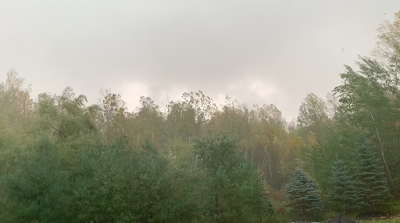
A bit of late foliage hangs on in St. Albans, Vermont early
this morning creating a spot of brightness on an otherwise
dark, damp and very rainy Halloween morning. 
As the National Weather Service advised us, we got a good drenching overnight and this morning in Vermont.  Anticipate a very wet day, especially during the first half of the day and especially north of Route 4. 

Unlike last week's nor'easter, which went out to sea and avoided Vermont, today's weaker but still potent storm was being captured by an  upper level storm roughly overhead. 

This will bring the center of the storm that was near Cape Cod north or northwestward today, ending up near Sherbrooke, Quebec this evening, notes the National Weather Service in South Burlington. 

It ain't going out to sea this time, folks. 

By the way, that powerful nor'easter that blasted the Massachusetts coast last Wednesday did something interesting over the open Atlantic Ocean last night. More on that in a bit.

First, this morning's weather setup is bringing a juicy train of moisture moving southeast to northwest through Vermont and other sections of northern New England this morning. 

Some of the rain is pretty heavy, especially in places where the wet air is forced to rise up the slopes of the eastern Green Mountains. 

As of 7 a.m., many of us had gotten a half inch of rain or more. By the end of the day, most of the Green Mountain State will have seen more than an inch of rain out of this, with some spots going past two inches.

This is enough to bring many of the state's rivers up to near the top of their banks, or even cause a bit of minor field flooding in spots. This is no disaster of course, but I think it's the first time this year that rivers in northern and central Vermont have been able to get that high. 

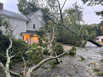
The storm has been worse in southern Maine and southeastern New Hampshire. There, three to six inches of rain has fallen and flood warnings are flying. Several roads in that area are impassable.

Just another example of how Halloween seems to inspire damaging New England storms. Read the full post on that from yesterday. It's an interesting history. 

Back here in Vermont, things should taper off tonight, so there's a little hope for trick or treaters tonight. Next it, a week of blah. 

BORING NOVEMBER

I've never liked the weather in November. It's dark, it's usually overcast and chilly and damp. Sure, we get some big storms sometimes. The worst weather disaster in Vermont history, after all, happened in November. That was the Great Flood of 1927 that took the lives of 84 Vermonters.

I certainly don't want that to happen again. Dull is much better than disaster, thank you very much. 

That said. we're about to settle into a typical November pattern of generally cloudy skies, the occasional risk of sprinkles and flurries, and raw temperatures for the next week or so. And possibly beyond. 

This year will certainly be the opposite of the opening days of last November, which brought us near record high temperatures and days of warm sunshine. This year, the first week of November will bring us the typical blahs we get this time of year. 

If you're prone to Seasonal Affective Disorder, I apologize for the bleak forecast.

NOR'EASTER BECOMES WANDA 

That nor'easter from last Wednesday that coastal Massachusetts is still recovering from had the power of a hurricane. After all, winds gusted to 94 mph on Martha's Vineyard and over 80 mph along much of the rest of the Massachusetts coast.

The storm was not tropical in any way, just a powerful nor'easter.

But something interesting happened to the nor'easter as it drifted east to southeast out into semi-oblivion in the central Atlantic Ocean.

The storm moved over warmer waters, and is now a hybrid. It still has the remnants of a cold core like a typical system, but is also acquiring tropical characteristics. As a result, it's now Subtropical Storm Wanda.

The storm is actually quite a bit weaker than when it was a full blown New England nor'easter. Top winds were around 50 mph this morning, and might go up to 60 mph in the next couple days.

Wanda could complete a full transition to a tropical storm in the next day or two as it drifts around the central Atlantic for a few more days.  Since it won't threaten any land areas, I'll call this system a Fish Storm Called Wanda.

Yeah, I went there.


Saturday, October 30, 2021

Final Days Of October Seem To Inspire Historic Vermont/Northeast Storms

Damage from this week's nor'easter in New England. Photo 
via Twitter from Michael Farragamo
The second of two major storms have just hit the East Coast within one week.  

The first a nor'easter with a peak wind gust of 94 mph blasted Massachusetts Tuesday and Wednesday.  Power is still out to some homes after the winds tore down innumerable trees and power lines. 

A second storm yesterday brought winds of up the 60 mph on the Jersey Shore and caused some damaging coastal flooding through the Mid-Atlantic states.  The flooding was among the worst on record, with some areas reporting among the top five storm surges in history 

Neither storm is having much of an effect on Vermont. The one that blasted the Mid-Atlantic States yesterday is forecast to dump an inch or more of rain on the Green Mountain State by tomorrow afternoon. Winds could gust over 40 mph in some areas, especially near the western slopes of the Green Mountains in this storm. 

So we get a fairly notable storm, but nothing extreme for Vermont. There might be a bit of minor flooding, and some isolated tree and power line damage. Luckily, this storm won't be as bad as it was further south yesterday.

This is history repeating itself, though.  There's something about the days around Halloween in the northeast that scare up some intense, historic storms. There's  been a ton of them.  Several of these storms cost hundreds of millions, sometimes billions of dollars, not to mention lost lives.

Here's a bit of a trip down memory lane with these (mostly) recent October storms. 

The Perfect Storm, October 31-November 2, 1991:  This of course is the storm made famous by the book and movie about the sinking of the fishing boat Andrea Gail during the raging storm that resulted in five deaths on the boat, part of a total storm death toll of 13.  

A tropical storm teamed up with a another non-tropical system to produce an immense storm offshore of New England. The storm produced winds of 75 mph on the coast, but worse, caused a devastating storm surge that caused upwards of $200 million in damage.

Halloween Snowstorm, October 29-31, 2011

Damage from a massive late October, 2011 snowstorm in
Glastonbury Ct. Photo by Jessica Hill/AP
Much like this year, autumn that year was warm in New England and other parts of the Northeast.  That meant that leaves stayed on the trees late into the season.  

Then a strong nor'easter got going off the coast, and pulled down some very chilly air from Canada. The result was a stripe of very heavy snow from northeastern Pennsylvania and northern New Jersey up through central and southern New England.

Northern New Jersey, southern New York, southern Vermont and New Hampshire and much of Massachusetts and Connecticut received 10 to 20 inches of wet, heavy snow. Peru, Massachusetts was smothered beneath 32 inches of snow. 

This all fell on those trees, the weight collecting on all those leaves still up there, and many of those trees collapsed under the burden. Over one million people in Connecticut alone lost electricity. Some people in the entire snow zone were without power for a week or more. 

Superstorm Sandy October 28-30, 2012

The sprawling storm, consisting of a hurricane making a transition to a non-tropical system took a weird path and made a left hand hook from the Atlantic into New Jersey on October 29, 2012.  It was one of the worst storms in American history. 

Superstorm Sandy killed 75 Americans, with an additional 72 deaths in the Caribbean earlier when Sandy was a hurricane. The storm destroyed 650,000 homes, and caused $70.2 billion in damage, mostly in New Jersey and New York.

Here in Vermont, we suffered just a glancing blow from Sandy, with power outages mostly across southern parts of the state.

Workers patch up a Milton, Vermont roof after a severe 
windstorm in October, 2017.
Bomb Cyclone, October 29-30, 2017

Another nor'easter developed explosively along the coast, causing widespread damage in and around New England.  

As we've seen in the past week, nor'easters often cause strong winds along the coast. If conditions are just right, these winds come way inland. And they did in this case.

Here in Vermont, strong, damaging winds are common right along the west slopes of the Green Mountains. This time, these downslope winds extended all the way to Lake Champlain, with destructive results. 

More than 150,000 Vermonters, one fourth the state's population, lost electricity.  Hundreds of Vermont homes suffered damage like lost shingles, sections of roofs gone, siding torn off or falling trees crashing into them. Winds gusted to 131 mph atop Mount Mansfield, 78 mph in Wells, Vermont and 63 mph in Burlington.

The storm also caused wind damage throughout New England, and destructive flooding in parts of New Hampshire and Maine.

Intense Vermont Flooding, Wind, October 31-November 1 2019

This tree uprooted and destroyed an SUV in our
St Albans, Vermont yard on November 1, 2019.
This storm, for a change, was not a nor'easter but still caused enormous havoc in Vermont. Parts of Vermont were declared disaster areas due to the worst flooding the state had seen since the devastating Tropical Storm Irene floods of 2011. 

Sections of two rivers in northern Vermont reached record crests. Numerous roads were washed out and dozens of homes and businesses were severely damaged by the flooding. 

Bridge replacement work continues to this day in Williston due to this storm.

The storm packed a one-two punch, first with the severe flooding and second with damaging winds. A number of properties in Vermont that escaped the flooding were damaged by the wind. This included my own place, where one of our vehicles was destroyed by a falling tree and our house suffered minor damage. 


Friday, October 29, 2021

It's Finally Getting Cold-Ish, But No Real Winter Weather Quite Yet

Remarkable amount of fall color for October 28 remained
in Richmond, Vermont yesterday. Trees are holding onto
their leaves longer than I can ever remember in this
remarkably balmy autumn of 2021.
 For the second morning in a row, there was a pretty good frost here in St. Albans, Vermont.  That's typical for this time of year, of course, but still notable in this persistently warm autumn.

The cooler weather in the past couple of days is a sign we're over that incredibly warm regime, at least for now. 

There's no real balmier than average weather coming in the foreseeable future. As we head into November, we get........normal November conditions. How novel!  

Meanwhile, the warmth has kept the fall foliage on the trees much longer than I can ever remember in Vermont. Driving around the Champlain Valley in yesterday's crisp, blue sky delightfulness, I was amazed at how pretty it still is out there. 

The "triplets," what I call three huge poplar trees in my back yard, are still mostly green, and have only shown signs of yellowing leaves in the past couple days.

By October 28, we're normally quite into stick season.

If you some sort of dark individual who is sick of gorgeous autumn colors, you're in luck this weekend. Another wet, somewhat gusty storm will breeze through over the weekend.  This won't be a blockbuster, but most of us will see a half inch to an inch of rain.  On the western slopes of the Green Mountains, some places could gust to 40 mph. The rest of us should see peak gusts in the 20 to 30 mph range over the weekend.

That should knock down quite a few remaining leaves.

After the weekend, we'll be in what is know as a cyclonic flow. That just means that next week, there's low pressure to our north in Canada. This will create brisk from the west and northwest, there will be lots of clouds, with scattered rain and snow showers. (Most of the snow will be in the mountains, of course).

So yeah, typical November.

For what it's worth, the six to 10 day outlook from NOAA has us in below normal temperatures for the period November 3 to 7.  This is the first time in quite awhile I've seen a forecast for 6 to 10 days out that didn't depict normal or warm temperatures for us. 

This won't be a full plunge into winter, thank goodness, as I for one am not ready for that. 

Thursday, October 28, 2021

Reponsibility-Free American Views On Climate Change

Thick haze from western wildfire smoke obscures the view
 of Lake Champlain from St. Albans, Vermont this past 
August. The effects of climate change have far-reaching
effects, but many people still don't regard this as a problem.
Vice News has reported that though 70 percent of Americans think global warming is happening, but 45 percent say these changes are not caused by humans. 

That aspect of the polling by YouGov on behalf of Vice News, The Guardian and Covering Climate Now, to me is pretty depressing.

That 30 percent of us think climate change isn't happening flies in the face of what we see around us. 

There have always been weather disasters, of course, but the many, unprecedented heat waves, the relative shortage of intense cold waves, and the waves of incredible storms should be a clue that something is amiss.

The other key point from the polling is at least as dispiriting. Nearly half of people in the poll say that climate change is not being caused by humans. 

It's the classic deflect: I didn't cause it, so it's not my problem. Or any problem at all. 

That's obviously not to say that any individual is causing the bulk of climate change. That, of course, is silly. But we're all contributing to the problem.  I commute to work in my Toyota Tacoma, heat my house, use electricity from power sources that come in part from fossil fuels and I likely waste stuff to the detriment of the environment.

Like many people, I'm getting better at this, trying to drive less, recycling, composting and thinking of other ways to mitigate my carbon footprint. 

Awareness that we, as individuals are in our own tiny ways contributing to climate change is a useful motivator to do a little better and advocate for change. Just denying that we have a hand in it is just  personal get out of jail free card, if you will.

To be fair, the people responding to the poll who say that climate change is not caused by humans are the victims of gaslighting. They're being fed this bullcrap by the politicians and lobbyists and pundits who, for fun and especially profit, want them to believe that.  

The tribalism that is now endemic in our society has a lot to do with the results of this poll. About 55 percent of Republicans inaccurately say that climate change, if they think it exists, is originating from natural causes, not humans

"Hey, not my fault, you can't control Mother Nature," seems to be the ethos.

Of course, you can read at least some of these poll results and conclude the glass is half full, sort of.  People do seem cognizant that climate change is having an impact. Nearly 60 percent of respondents said climate change has already harmed people in the United States. (Just under 84 percent of Democrats agreed with that statement). 

Many people are also starting to take action. According to Vice:

"A majority of Americans say they're already flying and driving less, using less electricity at home and recycling. About half are also either already eating less meat or willing to do so, and nearly two-thirds support purchasing products from eco-friendly businesses."

Check out the full Vice article. It has a lot of interesting polling tidbits. 


Wednesday, October 27, 2021

Nor'easter Blasts Massachusetts Coast; Gusts To 94 MPH

The Duxbury, Massachusetts Fire Department posted
this photo of nor'easter damage in that town this morning.
Thank goodness the big nor'easter stayed off the coast.  

Had it come closer or moved just inland, virtually all of New England would have had an incredibly destructive blow.  

Since this one stayed offshore, most of the havoc is south and east of Interstate 95 in southern New England.

There's plenty of havoc, though! As many suspected,the storm really over-performed in terms of wind along and near the Massachusetts coast.  Edgartown, on Martha's Vineyard, gusted to 94 mph early this morning. Other wind reports include gusts to 87 mph in Scituate, 84 mph in Duxbury  and several gusts over 80 mph on Cape Cod.

The storm was rapidly strengthening when those high wind gusts hit. You tend to get the highest winds in a nor'easter when the storm is in its fast building stage. 

The National Weather Service was advising everyone along and east of Interstate 95 to stay indoors this morning because so many trees and wires were falling.  At last check, more than 400,000 people in Massachusetts had no electricity. 

Luckily, there was a fairly sharp cut off between destructive winds to the east and not so bad to the west. Gusts were mostly in the 40 to 45 mph range north and west of Interstate 95, so there weren't too many problems once you get inland. 

Even though astronomical tides were low, there was still storm surge flooding and immense, crashing waves hitting shore. 

Today's nor'easter hit just days before the 20th anniversary of the Perfect Storm, that famous storm depicted in the book and movie. Though this nor'easter isn't quite as bad as the Perfect Storm, it's still a powerhouse.

The winds will this nor'easter will slowly diminish through the day as the storm center lumbers gradually to the east and out to sea.  It might take on some tropical characteristics once it's way out there, but at that point won't be any threat to land.

Here in Vermont, the only effects we'll see from the nor'easter today are some gusty winds reaching at times to 30 mph.  That won't cause any problems other than ripping much of the remaining fall foliage from the trees. Some sunshine will develop today as well, giving us a break from two days of gloom.

The next storm comes along Friday night and Saturday. Unlike some forecasts that were made earlier in the week, this next storm doesn't look all that scary.  I guess no spooky weather moments for Halloween this year.

We'll get a decent slug of rain Friday night and Saturday, but it will be a typical storm. Maybe a half to three quarters of an inch of rain.  There had been some fears that the upcoming storm might carry the risk of damaging winds, but now we see that won't happen. 

Just plan your indoor stuff for Saturday and your outdoor stuff for Sunday, as the storm will have pretty much departed by then.


Tuesday, October 26, 2021

Bomb Storm Sweeping Northeast; Just A Rainfall Here in Vermont

Satellite view of "bomb nor'easter" organizing off the
New Jersey coast this morning. You can see a lot of 
thunderstorms bubbling up southeast of New 
England, which is one of many signs this storm is
strengthening rapidly. 
An impressive so called bomb storm is causing a lot of trouble for the Northeast today with flooding, damaging winds and battering coastal waves, while we here in Vermont endure just another rainy day. 

A bomb storm is defined as one whose central air pressure drops by 24 millibars within 24 hours. Most of the time, the lower the air pressure in a storm the stronger it is. 

When the pressure's dropping fast, the storm is intensifying really quickly, and that situation can cause a dangerous storm.  

When a storm is strengthening like that, it tends to cause more trouble than when it's holding steady or weakening. The winds tend to be stronger in a storm that's growing more powerful and the moisture supply for heavy rain is increasing.

That's what's facing the Northeast.

The storm will probably "overperform" on Cape Cod and the Islands tonight, where gusts of at least 70 mph seem likely.  Leaves are still on the trees down there. Each leaf acts like a little sail in high winds, tugging the tree downwind much more than if the trees were bare.

That makes the trees more likely to topple over. In any event, they're telling everyone to take down their Halloween decorations and not park their cars under trees tonight. 

This type of storm can cause some big coastal storm surges and flooding as well. Luckily, astronomical tides right now are on the low side, so that will help prevent some damage. 

The storm has already dumped more than three inches of rain in New Jersey, and flooding is ongoing there. The high water isn't as bad as it was in September with ex-Hurricane Ida, but the flooding is causing new misery in a state that has been hard hit by repeatedly flooding and storms this year.

Heavy rain will cause flooding in southeastern New England tonight. 

This bomb nor'easter was still consolidating itself this morning. It's offshore of New Jersey, feeding off the warm waters of the Gulf Stream, and even taking on a little bit of tropical characteristics.

This bomb is in the process of absorbing a weakening separate storm on the Mid-Atlantic Coast. This arrangement is feeding rain northwestward across New England and into southern Quebec, which is why it's so rainy in Vermont this morning. 

Once the storm consolidates, it will draw the heavier rain closer to the main storm. This should help the rain taper off in Vermont today, especially north. So it won't be a mega storm for us.  Southern Vermont could get over an inch of rain out of this. The north should see a half inch or less, on top of the third of an inch or so we received yesterday.  

So nothing to write home to Ma about. 

As the storm lurks off the coast tomorrow, we'll be close enough to receive wind gusts as high as 35 mph across Vermont. That's not at all dangerous, but it will strip most of the remaining colorful leaves off the trees. Foliage season is just about over, folks. 

It's also pretty interesting that this "bomb nor'easter" in New England got its start from two other "bomb storms" that hit the West Coast in recent days with flooding rains and high winds. 


Monday, October 25, 2021

Stormy Weather Update: In Vermont, Not So Bad North, Very Wet South, Coastal NE To Be Blasted

National Weather Service in South Burlington put out this
forecast map for rainfall today through midday
Wednesday. Less than an inch of rain in northern
Vermont, but up to two inches or even locally
more in southern Vermont. 
 As expected, it's a cold, rainy morning in Vermont, with even some wet snow up in the mountains and the Northeast Kingdom. 

The snow won't amount to much, and we'll just have general gloom and wetness today. 

The main show is tomorrow. Here in Vermont, northern parts of the state look to be once again largely bystanders, while central and southern New England, and parts of the Mid-Atlantic States get blasted.

A storm coming in from the Ohio Valley - partly responsible for today's murkiness - won't "capture" the developing nor'easter enough to pull it inland. 

Instead, the storm will bomb out, which means it will intensify super fast, and then perform sort of a loop as a relatively small sized but powerful storm just off the New England coast. A huge amount of moisture will be blown in off the Atlantic Ocean.

Southern New England could see three to five inches of rain out of this with as much as two or three inches in just six hours.  Flood watches are naturally up for that neck of the woods. Winds could gust up to 70 mph on Cape Cod and the islands. With leaves still mostly on trees in that area, the wind would knock over the trees much more easily than if this hit in the dead of winter. 

The New York City area and New Jersey have been socked by flooding repeatedly this year, most devastatingly in September with the remnants of Hurricane Ida.

New flooding is likely with this storm in that area. Though it probably won't be as bad as the Ida floods, more damage and more danger will come out of this storm. 

Once again, up here in Vermont we appear to be lucking out. No disaster here.  I wonder when the other shoe will drop?

Anyway, there could be as little as a quarter inch of rain for a storm total from this morning to Wednesday morning in the far northeast corner of Vermont to locally as much as three inches in the east facing slopes of the far southern Green Mountains. 

For most areas north of Route 2, the National Weather Service in South Burlington is going for an inch or less of rain. and 1 to 2 inches in southern Vermont, with of course locally more in Bennington and Windham counties. 

There could be minor flooding out of this in southern Vermont, but I don't expect an enormous problem out of this in the Green Mountain State.

Though foliage was past peak, there was still quite a bit of color
left yesterday in the Champlain Valley of Vermont, as this
photo from St. Albans indicates. A lot of those leaves will
be blowing off in the wind and rain this week.
Sunday was the last truly sunny day we'll have for awhile. Though foliage was a bit past peak in Vermont's Champlain Valley yesterday, there was still a remarkable amount of color for October 24. Very late in the season. 

A lot of those remaining leaves should be blowing off in the rain and wind gusts in the 25 mph range. 

We're still expecting a break until the weekend, when another storm will loom, but it's still too soon to figure out exactly how that one will evolve.

Elsewhere, at least 15 tornadoes were reported in Missouri and Illinois yesterday.  More severe weather will probably rake the middle of the nation over the coming couple of days.

And, as expected, there were landslides, flooding and debris flows from a torrential storm in northern California yesterday. 

Sacramento, California had its wettest day - not just the wettest October 24 but the wettest day period - on record Sunday with about 5.4 inches of rain.  There was also quite a bit of flooding in the San Francisco Bay area.

Sunday, October 24, 2021

Burlington Freezes, And Vermont/New England About To Get Very Wet

Storminess over the next seven days will unleash a lot of
rain across much of the nation. The orange areas on
the West Coast and New England can expect more 
than six inches of rain over the next week. 
 Burlington, Vermont will not be breaking its latest freeze record after all.

It got down to 32 degrees at the National Weather Service observing site at the airport in South Burlington at 7 a.m. this morning. So the record for the latest first freeze of the season stands at November 1, 1920.  

Some big asterisks with this record, though. In 1920, temperature readings were taken closer to Lake Champlain than they are now.  It's usually a bit balmier in the morning this time of year near the lake because of the lingering warmth in the lake water.

It's possible - I would say likely - that there was an earlier freeze in 1920 at the site of the future airport than on November 1 that year. It was 33 degrees on October 13 and 30 in the 1920 data, so it was probably 32 or lower on October 13, 1920 at the South Burlington site where temperatures are now recorded. 

For this week, we're going to go from frosty to wet.  Very wet, probably in southern Vermont. Though northern Vermont will also get in on some rain action. 

Two major storms will affect New England, one centered tomorrow and Tuesday, the other hitting around the weekend.

After this morning's frost melts off, it will actually be a pretty nice day in Vermont. There will be a fair amount of sunshine, and temperatures will pop up into the seasonable 50s by afternoon.

As I said yesterday, there will be changes to this week's forecast due to a complicated weather pattern, and that iffiness seems to be bearing out, at least to some extent. 

Rain will move into Vermont late tonight and tomorrow morning with an initial push of moisture. Rainfall at this point looks like it might become for sprinkly and drizzly during the afternoon.  But it will still be a raw, dark, icky Monday. Temperatures wills stay in the 40s.

The best guess is that about a half inch of rain will fall on most of us with Monday's wave of wet.

It now looks like a pretty powerful nor'easter will get going just off the New England coast Tuesday.  That will concentrate the rain in southern New England and southern Vermont, though all of the Green Mountain State should have a wet Tuesday. 

The National Weather Service in South Burlington says the nor'easter will bring about a half inch of rain to the Northeast Kingdom to 1.5 inches in southern Vermont. 

It hasn't been super wet lately, so this rain shouldn't lead to any real flooding in Vermont. 

Southern and eastern New England will probably have to contend with some flooding, coastal erosion and gusty, possibly damaging winds with this system on Tuesday.

We get a break in the action midweek before the next storm arrives for the weekend. There's plenty of questions as to exactly where that one will go and how strong it will be. But there's still potential for strong winds and heavy rain with it. We'll have to wait and see how that plays out. 

TROUBLESOME NATIONAL WEATHER

What might well become the strongest storm on record off the Pacific Northwest coast is looming today and tonight. The core of the storm won't come ashore, so there won't be a devastating wind storm like what happened during a similarly strong, but closer and windier storm in 1962.

However, this storm continues to drive at atmospheric river of water into northern California, so they're still bracing for flooding and debris flows, especially near where there were recent big wildfires. Evacuations are ongoing. 

Meanwhile, the storm that will eventually develop into the New England nor'easter on Tuesday is today unleashing the threat of tornadoes in and around Missouri, and a substantial risk of flash flooding in parts of Illinois and Indiana.


Saturday, October 23, 2021

Vermont Finally Has First Freeze While Weather Pattern Set To Turn Wild Again

Hand print in the frost on my truck this morning, St. 
Albans, Vermont. Growing season is over for this year.
Much - but not all - of Vermont was below freezing early this morning, ending a remarkably long growing season for many of us. 

Northern and central Vermont outside parts of the Champlain Valley were icy this morning, with temperatures generally between 29 and 32 degrees as of 6 a.m.  

The northern Champlain Valley away from the immediate shore of the lake did have a frost and freeze, as demonstrated by the thick layer of ice on my truck windshield in St. Albans this morning. 

Plattsburgh, New York was also below freezing before dawn today. 

St. Johnsbury established its record for the latest first autumn freeze on record as it finally got below 32 degrees there early this morning.  The old record was October 21, 1905, says the National Weather Service in South Burlington. 

Montpelier will not be setting a record for latest freeze. It was 31 degrees there this morning, so their latest freeze record of October 31, 1975 will stand. 

Burlington looks like it just barely missed a freeze this morning, but broke its record for the latest first 40 degree reading.  It got down to 35 degrees in Burlington this morning, so that establishes the record for the latest first 40 degrees. The old record was October 21, 1975.

Plants we wanted to save were warm and snuggly inside our
house this morning after my husband Jeff remembered to
bring them indoors ahead of this morning's frost.
The record for the latest first frost in Burlington is November 1, 1920.  There's a very good chance of a frost and freeze in the Burlington area tonight, so that record could well stand.  If you somehow escaped having any frost damage outside your house and you still want to bring plants indoors, better do it today. 

Normally, I wouldn't make a big deal about frost in late October so it's so common, but in this topsy turvy weather year, what was once normal is now strange. Go figure.

VERY ACTIVE WEATHER PATTERN

Two days ago, I mentioned heavy rain moving into California this weekend, the product of two intense storms and an atmospheric river. 

Since weather generally flows west to east, you can't expect the California storminess to just disappear. What goes on in California doesn't stay in California.  

 These systems will move across the nation, causing all sorts of hazards, and giving us in Vermont a really wet week.  That represents a change in the forecast, as the upcoming week was originally scheduled to be kind of dry.  More on that in a moment. 

In northern California, the storms will prove to be a little too much of a good thing.  They desperately need the drought relief, but the moisture coming into California is basically a fire hose.

Parts of northern California can expect seven or more inches of rain just on Sunday.  As these torrents blast the areas burned by recent wildfires, there could be massive and destructive debris flows. Parts of California have been placed under a high risk of this happening.

The initial wave of the California storminess has already come and gone out there, and is emerging into the Plains States. This is going to cause the first of two severe storm outbreaks in the middle of the nation. 

Some severe storms are forecast around parts of Nebraska, Iowa and Missouri today, but the main show comes Sunday. 

That will be centered in and around Missouri on Sunday, with tornadoes, large hail and damaging straight line winds expected.  This activity will shift into the southern and central Appalachians Monday. 

That second, stronger wave of storms off the Pacific Ocean will make their way into the Plains by Tuesday and Wednesday, promising another wave of severe storms and tornadoes. 

Usually, we expect big severe outbreaks to happen in the spring out there, but there's a smaller, secondary peak in activity in the autumn, and that's what we're experiencing.  This autumn's peak seems bigger than most years, as we've already seen tornadoes in Oklahoma earlier this month, and in Ohio and Pennsylvania just the other day. 

VERMONT IMPACTS

As noted, it's going to be a wet week.  Initial forecasts had the storm causing the severe weather this weekend to pass mostly south of us, but now, we're in on the action.  By the time the system gets here, it will have slowed down, so we'll have a long period of rainy weather starting late Sunday night and continuing at least through Tuesday. 

It might not rain constantly, but it will be wet most of the time during this period. During the onset, it might be cold enough on the mountain peaks for a couple inches of wet snow.  The vast majority of us will only see a chilly rain out of this, however. 

At this point, rainfall totals look like they will amount to a half inch to an inch Sunday night through Tuesday night. 

That second, stronger wave of storminess looks to affect us toward the end of the week.  Early indications show the potential for strong winds and heavy rain, but it's too early to know for sure. 

This is one of those evolving weather patterns, so I and everybody else will need to keep updating and making forecast adjustments as we go through the week


Friday, October 22, 2021

Relatively Rare (Possibly!) Asperatus Clouds Create Weird Vermont Skies

Before sunset, the odd clouds overhead in St. Albans, Vermont
on Tuesday consisted mostly of bluish and gray waves.
On Tuesday, an overcast, sprinkly, somewhat chilly day here in St. Albans, Vermont, the sky definitely got weird.  

What appears to be a fairly rare cloud called undulatus asperatus graced the skies. This type of overcast looks sort of like what a choppy sea must resemble if viewed from just under the water's surface.

This cloud was only recognized as its own category of cloud by the World Meteorological Organization back in 2017.  

The headline on the linked article is titled "Earth's Newest Cloud Is Terrifying," but not really.

In some cases, asperatus clouds do look threatening.  The ones over St. Albans on Tuesday were just weird.  You are not in danger if any of these clouds happen to be overhead. 

I'm not entirely sure these were true asperatus clouds over St. Albans.  They usually form near convective showers and thunderstorms.  While there were some weak showers in the area, there weren't any robust storms nearby. So they might just be cool clouds. 

I'll leave readers and the experts to judge.

Keep scrolling for more photos of the clouds, and at the bottom of the photos is a quick YouTube video I put together of the phenomenon.  You'll need to click on this link to view the video on mobile devices.

The setting sun began to add color to the strange skies. 

Between the odd clouds and the setting sun lighting up
trees in a strange orange hue, it suddenly felt like
St. Albans, Vermont was on some other planet. 

Sunset and odd clouds on Oct. 19 over St. Albans, Vermont.

Here's the video: Click on the arrow, and then the YouTube logo to view in fuller size:


Thursday, October 21, 2021

California Dreaming: Early, Welcome Start To Wet Season Out There

Predictions call for more then ten inches
of rain in parts of northern  California
over the next seven days.
The headlines regarding California's drought have been growing ever more dire, and I see little prospect of improvement. 

Except.  

Storminess is moving in that will if nothing else raise Californians' spirit, and even end the wildfire season in the northern parts of the state.

Some of the most devastating and deadly northern Californian fires have hit in late October and November in recent years. For instance the fire that all but destroyed the northern California city of Paradise and killed 85 people was in November, 2018.  

This year, the first heavy rains are moving in during mid-October. The drenching should suppress any ongoing fires and prevent new ones. 

Forecasts for the next week call for up to ten inches of rain in some sections of northern California.  Most areas from the San Francisco Bay area and Sacramento could easily see three or more inches of rain by next Tuesday.

Several feet of snow could fall on the highest elevations of the Sierra Nevada.

This would effectively end the fire season in that part of wildfire and drought plagued California. 

Even areas between the Los Angeles area and San Diego could see a half inch or more of rain out of this by early next week.  

One big autumn storm will not solve California's serious water crises. The state's "water year" runs from October 1 through September 30.  The one that just ended on September 30 of this year was California's driest since 1924. 

Big cities like Los Angeles, San Francisco and Sacramento had less than half the rain they should have during the 12 months ending on September 30.

As previously reported, reservoirs like Lake Mead are at dangerously low levels and would probably need a string of wet winters to fully recover. 

Still, this early taste of water from an expected atmospheric river off the Pacific Ocean puts Californians in a good frame of mind.  If the weather pattern persists through the winter - a very, very iffy proposition - then Californians can relax just a bit next spring. They'd still probably be in drought, but not as bad as the conditions they have now.

The only drawback to the heavy northern California rains over the next week is a legacy of the intense drought they've had.  Wide areas of the landscape are burned over by wildfires from this year, and recent years.

With the vegetation burned away, soils are no longer held in place. There will be flash flooding and debris flows and mud slides coming up.

Since southern California is just getting a glancing blow from these wet weather systems, the intense drought will hold firm there, despite the brief wetting. 

In fact, there's still time after this rain for things to dry out again.  Fire season isn't over in southern California if drying, strong Santa Ana winds develop as they often do in the late autumn and early winter.

Wednesday, October 20, 2021

Finally Time To Bring Those Plants You Want To Save Indoors

Flowers on our St. Albans, Vermont deck looked amazing
for October 20 but we'll finally have to take them indoors
or let them go as very belated frosty weather is due 
over the weekend. 
 While enjoying a glorious moonset with a shimmering Lake Champlain in that moon light, I had to run back indoors to get a jacket. I was cold! 

The cold shouldn't have surprised me. It's the third week in October. It's supposed to be cold in the morning.  We simply haven't had much chill yet, and I still don't have my sea legs in dealing with it. I'm still marveling at how little of this weather we've had. 

As of 6 a.m. in Burlington, it was 42 degrees. Actually a couple degrees above average for a low temperature this time of year. 

WPTZ-TV meteorologist and numbers cruncher extraordinaire Ben Frechette tells us, Burlington has a great chance at breaking the record for latest first autumn day with temperatures under 40 degrees. The record is October 21, 1905. 

And even that record is suspicious in a way.  Back then, Burlington's temperature readings were taken closer to Lake Champlain, where it is warmer. Now they're taken at further inland at the Burlington International Airport in South Burlington. That's further from the lake, and thus usually chillier in the morning. Chances are it was in the 30s where the airport would eventually stand back in 1905 before October 21.

In other words, this all makes the lack of under 40 degree weather all the more remarkable.

The average date for the first morning under 40 degrees in Burlington, by the way, is September 9.  So yeah, we're really late.

All records trends must end, and this one will too. Mount Mansfield just had its latest first freeze on record yesterday. And it will finally go below 40 degrees in Burlington this weekend. 

We'll have a couple more warm days ahead of the next cold front. It will pop up into the low 60s for many of us today, then stay fairly warm tonight. Some showers arrive amidst the warmth Thursday and then temperatures will start to go downhill again. 

It will be noticeably cooler on Friday, and that's the day you'll need to take inside any plants out on your deck or porch that you want to save. It's also the day for most of us to day goodbye to the still remarkably healthy flowers still out there in the gardens.  

There's still some debate as to how cold it will get this weekend, but most of us should expect a frost and/or freeze at least once sometimes between Saturday night and Tuesday morning. It still could manage to stay above freezing in the warmer, broader valleys during that time, especially right next to Lake Champlain. 

The colder forecasts have snow showers all the way down to valley floors on Sunday.  The warmer forecasts keep daytime temperatures pretty reasonable near 50 degrees during the weekend and early next week.

Either way, the chilly forecast is by no means odd. What is weird is the warmth we had so far this month. 

By the way, we're probably not done with balmy weather. After this cool spell passes, signs point to a big warmup during the middle of next week. 


Tuesday, October 19, 2021

Gloomy Day Turns Into Glorious, Ultra Colorful Surprise: Photo Essay

The big autumn rainbow over St. Albans, Vermont on
Monday. 
 I love what I call "come to pappa" moments in my weather geekdom.

Those are the moments when I don't have to seek out any interesting weather. No effort, no muss, no fuss.  

I had one of those wonderful incidents yesterday, when a quick trip to the door to let the dogs out to do their business led to the glorious surprises you see in this post. 

It had been a chilly, gloomy October day.  The skies all day had been gray and overcast, and sporadic showers kept things damp and dank.  Late in the afternoon, the showers intensified as breaks formed between those rain clouds. 

As the sun headed toward the horizon for the evening, all color broke loose.  The combination of dark clouds, bright sun, foliage was just the background.  A brilliant rainbow, one of the brightest I can remember formed behind the house. 

Another view of yesterday's double rainbow and fall
foliage in St. Albans, Vermont. 
I didn't have to go anywhere to enjoy the ultimate autumn show in Vermont. Just open the door and gawk. 

To best look at the photos, click on each one to make them bigger and easier to see. Scroll down past this verbiage as well to check out all the photos. 

I even took a brief video and posted to YouTube. You can see it below the photos, but if you have a mobile device, you'll want to click on this link to view it. 

I'm not sure if today will bring any more happy weather surprises.  The only new "news" to report is that the summit of Mount Mansfield finally touched 32 degrees this morning, making it the latest first freeze of autumn up there. It broke the old record by a whopping 13 days. 

The weather is forecast to be quite variable for the rest of the week into the weekend. Maybe a recipe for more photogenic weather? We'll find out! 

More photos and video:

Double rainbow, fall foliage, dark clouds Monday afternoon
St. Albans, Vermont 

Sun shines brightly on fall colors late Monday afternoon
as dark clouds and rain loom overhead, St. Albans, Vermont. 

Dark clouds, bright sun and fall foliage, St. Albans, Vermont

Roiling clouds and a shaft of rain are lit it by the setting
sun Monday in St.Albans, Vermont. 

Video: Rainbow, setting sun, clouds and foliage in St. Albans, Vermont Monday:


Monday, October 18, 2021

Belated Snow Finally Hits Vermont/New York Mountain Peaks

Web cam shot from the summit of Sugarbush, Vermont today. 
Better late than never.

Snow was reported on the tallest mountain peaks of Vermont and New York today, bringing the first whitening since late May to the Green Mountain State.

Web cam from Sugarbush showed snow dusting the evergreens at the summit.  It was 34 degrees and snowing atop Mount Mansfield this afternoon.

The National Weather Service in South Burlington said elevations at 4,000 feet or so have had light accumulations. 

That covers only the tippy tops of the tallest mountains in the region. Snowflakes have been spotted as low as 3,000 feet, but they're not sticking there. 

During a heavier rain shower near the valley floor in St. Albans, Vermont, a tiny bit of hail or graupel briefly mixed with the rain.

Spectacular rainbow amid the chilly autumn showers in 
St. Albans, Vermont late this afternoon. 
None of this is remotely unusual for this time of year. Snow often falls on valley floors in mid-October.  

Dustings of snow accumulated at my place in St. Albans on this date in 2015 and 2018, for instance. Still, since it's been so warm this autumn, today's  mountain peak snow seems noteworthy.

It looks like Mount Mansfield has an excellent shot at finally getting below freezing tonight. The summit's previous record for latest freeze was October 6, 2011, so the record up there is shattered.

No frost is expected at lower elevations tonight. The next chance of frost and freezes in Vermont will be this upcoming weekend. 

Some of today's showers were unexpectedly heavy.  My unofficial rain gauge in St. Albans picked up a half inch of rain today,  mostly from three downpours that passed through. 

As you can see in this post, the last downpour of the day created a spectacular rainbow over St. Albans. 

Can Beer Help With Climate Change?

The Alchemist's famous Heady
Topper IPA.  The brewery has 
found a way to capture its carbon
emissions and use it to produe
their microbrews.
 I have one thing in common with U.S. Supreme Court Justice Kavanaugh: I like beer. 

Beer is fizzy and bubbly because there's carbon dioxide in it. That's better than being in the atmosphere, where it contributes to climate change. 

I'd like beer even more if breweries found ways to reduce their carbon footprint. 

Breweries, like almost all businesses, emit carbon dioxide in the course of operations.  So why not put their carbon emissions directly into the beer instead of the atmosphere?

Large breweries already do that, but the technology wasn't really there to allow microbreweries to sequester their carbon emissions into their beer. They had to buy canisters of carbon dioxide separately. Until now. 

As VTDigger reports, The Alchemist is the first Vermont brewery to be able to capture the gas and use it for carbonation.  

The Alchemist -famous for its award winning Heady Topper - had tried to find technology to capture carbon, but nothing really worked. According to VTDigger:

"Then, at the end of last year, they heard about Earthly Labs, a company based in Austin, Texas that makes a carbon capture system for breweries of their size. CEO Amy George is set to have about 50 operations around the country using the system by early next year, she said, and so far her product has been well received."

The Alchemist is running this carbon capture system at its Stowe brewery and plans to add it to their Waterbury operation.  The carbon capture system costs about $120,000, but breweries spend thousand of dollars buying canisters of carbon dioxide, which will no longer be necessary once these carbon capture gizmos are installed at microbreweries. 

Vermont has more than 50 microbreweries. 


Sunday, October 17, 2021

Storm Summary And Fall Has Finally Arrived In Vermont

Screen shot of trees near my house in St. Albans, Vermont
being tossed by estimated wind gusts of 50 mph as
a damaging squall line roared through Saturday afternoon.
 Yesterday's line of rough storms in Vermont caused their share of damage as expected, but it could have been worse. 

Tree and power line damage was reported across many scattered locations in eastern New York and western Vermont.

For what it's worth, I took a video of the storm as it passed through St. Albans with gusts estimated of at least 50 mph.

Just up the hill from my house, the storm dropped a tree on a car and some power lines, and apparently started a house fire.

Video is at the bottom of this post.  It won't show up automatically if you're reading this on a phone, so click on this hyperlink to view.

On to the storm analysis!

 In advance of the storm, it had looked like some brief spin up tornadoes could possibly form in the Champlain Valley.

It turns out there were just two intriguing spots that could have produced a spin up, one in New York, one in Vermont. By far the most suspicious area was  a little southwest of Saranac Lake, New York.

There, radar seemed to indicate debris lofted into the air at one point. That's a pretty powerful signal of a potential tornado, but it's still not clear as to whether anything touched down there or not.   

One video taken in the area at the time shows what could be a funnel or tornado, perhaps.  Hard to tell because whatever was there was partly obscured by heavy rain. Some trees in that area were damaged, and part of a barn roof was torn off, according to WPTZ meteorologist Ben Frechette.

In Vermont, a radar scan briefly showed what is known as a "couplet" near Vergennes. That's where radar detects strong winds blowing in opposite directions in very close proximity aloft.  That could be a sign of an impending tornado. 

In this case, the couplet dissipated really quickly, and that makes me pretty sure nothing twisty touched down there.  

The straight line winds that raked the region with the squall line were certainly damaging, but they could have been worse, too.  Some of the worst winds were deflected just a few hundred feet above ground level.

 One radar scan clocked winds of up to 79 mph approaching Burlington just 200 feet above the surface. But down where people live, the highest gust at the National Weather Service office was just 44 mph, and a few places around Burlington surely gusted to about 50 to 55 mph. 

In most of northern Vermont north of Route 2, Saturday's storm for most people probably did more good than harm. 

The U.S. Drought Monitor still has areas along the Canadian border in moderate drought, and the area of Vermont considered "abnormally dry" expanded in the past couple of weeks to two thirds of the state, instead of the northern third the previous week.

Saturday's rain was a good soaker. Burlington reported 1.2 inches of rain, and my unofficial rain gauge in St. Albans, Vermont captured 1.45 inches. We need the rain. 

Going forward, I guess we can now finally declare that summer is over. The weather in Vermont could have passed for August in the past week. The well-advertised cooler air is now here, and that will only intensify tonight and tomorrow. 

As I've been saying right along, this colder air isn't at all unusual for October, but it is quite a change.  They're still expected some wet snow flakes at high elevations tonight through Tuesday.  Quite a few clouds and scattered light, chilly rain showers are a good bet, especially in northern Vermont into Tuesday. 

Nights will be too cloudy and breezy early this week to create any frost, so most of us will keep creeping closer to the record for the latest first autumn frost on record. 

We might or might not break those records. The next chance for a frost/freeze I see is probably next weekend. 

Here's the St. Albans storm videoClick on the arrow, then the YouTube logo to view it in full size:


Saturday, October 16, 2021

Strange Vermont October Warmth Went Out With A Damaging Bang Today

UPDATE 5:30 p.m.  SATURDAY

Maybe kind of hard to see just from this screen grab of 
a video, but trees behind my house in St. Albans, 
Vermont really being tossed by strong winds as today's
severe warned squall line swept through 
That line of storms as of this hour is entering the Connecticut River Valley and will be out of Vermont soon.  


Pretty dramatic storm as it came through St. Albans, Vermont, as observed at my house, but no damage here. 

 Now my road (Route 36) is closed.  The sheriff deputy blocking the road didn't have details, but said a tree fell on a car and power lines, and a house also caught fire in the incident. 

He had no word on injuries, or the extent of damage to the house involved. 

Elsewhere, downed trees blocked at least two roads in Essex, Vermont. As of 5:15 p.m., about 1,600 Vermonters had no electricity due to the storms. 

I'm sure more damage reports will filter in this evening, but thankfully, this was no blockbuster storm. At least for most of us. 

Except for perhaps far eastern Vermont, the severe weather threat is over. Widespread showers will continue well into this evening as temperatures slowly fall.  


UPDATE 12:30 PM SATURDAY
NOAA's Storm Prediction Center has chances for
tornadoes in parts of the Northeast. The highest,
but still relative low risk is in brown areas 
of the map.

As of shortly past noon, the chances of severe storms at least in western Vermont and eastern New York seem to be ramping up some.  

NOAA's Storm Prediction Center has upped the chances of a brief tornado in the Champlain and northern Hudson Valley late this afternoon, with the caveat that the chances of that happening are still quite low. 

According to the SPC's updated map, there's a 5 percent chance of a tornado within 25 miles of any spot in the Champlain Valley. 

That's the brown area of the map in this post.  Earlier, the SPC had given all of western Vermont and some adjacent areas a 2 percent chance of a tornado happening with 25 miles of a given location.

It's a low risk for sure, but it's unusual to have that high a risk in Vermont, especially in October.  And the map is awfully similar to the one in March when we had that tornado in Middlebury.  I'll repeat my statement from this morning that history probably won't repeat itself, but it's still interesting.

There's plenty of fuel for strong storms today.  As of noon, the temperature in Burlington was 76 degrees with a very high dew point of 65 degrees.  That's pretty much sufficient to help initiate storms. There are breaks in the clouds south of Burlington, which will help destabilize the air further. 

On top of that, the winds aloft are increasing in speed, and they're changing directions with height. 

Showers have been pretty persistent in the northern Champlain Valley, pretty much north of Milton, so I wonder if that will suppress the severe threat a bit in Franklin County.  I'm not sure, but that's a possibility

Severe storms are possible anywhere in Vermont as that line comes through later today ahead of the cold front. A severe thunderstorm watch is up for all of Vermont except the farthest reaches of the Northeast Kingdom until 7 p.m. this evening. 

If I were forced to predict the most likely place for a severe storm or brief tornado, I'd suspect it would be very roughly along a line from Fair Haven in western Rutland County north to Burlington. 

By far your best bet is to have an ear to a NOAA weather radio or any of our fine meteorologists at local television stations. The TV meteorologists will break into regular programming if there's any dangerous weather to warn us about. The National Weather Service office in South Burlington have their eyes firmly on this.

So just pay attention and do whatever they tell you to do, like take shelter in the event of a storm.

Also know that in the unlikely event of a tornado, the type of spin ups in this situation are often hard for meteorologists to see in advance. They'll spin up between radar scans, then disappear before the next radar scan goes through. That ups the chances that there might not be a warning.

The meteorologists will highlight any suspicious areas for you. But if you see menacing clouds, even if there's no weather warning, it will probably be best to get into a pretty sturdy building, just in case. 

Also note that most of us won't see severe, damaging weather today, but some of us might. Be weather aware! 

If there are any tornadic or severe thunderstorms, they will be right around kinks in the line of storms expected to move through later this afternoon.  

PREVIOUS DISCUSSION

The long warm spell we've had this month is still scheduled to come to end today with a bit of a bang. 

Some of you might have already heard some banging early this morning as the storm system's warm front produced a few thunderstorms along with the showers that passed through. 

Later today, expect some storms to be strong or even severe as they come through Vermont. There's even a very, very low, but not zero chance of a tornado in western Vermont today. Very strange for October! 

Speaking of strange, I do have to pause here and remark about how warm it's been this month, especially at night. The average low temperature in Burlington so far this month, through yesterday, is 53.3 degrees. That's more than 10 degrees warmer than average. 

There's already a lot more leaves on the ground in my 
St. Albans yard as winds pick up this morning. A lot
more of those orange leaves will be on the lawn by 
tonight with windy weather today, and possible
severe thunderstorms late this afternoon or evening.

Days have been almost as warm. Remarkably, today with be the sixth consecutive day of highs in the 70s in Burlington. I've seem stretches of weather like that in Vermont in July. 

We have had one of our warmest, if not the warmest first half of October on record. 

The summit of Mount Mansfield is still waiting for its first frost of the season, by far the latest on record. Overnight lows up there have been in the 50s for four straight days.  The summit of Vermont's tallest mountain does look like it will see its first freeze of the season Sunday and/or Monday night. More on that in a moment

We will have yet another warm and oddly muggy day here in Vermont today before that cold front makes it into the state later today and this evening. There will be a difference from previous days, though:  Unlike the relatively calm winds of the past week, gusty south winds have developed, especially  in the Champlain Valley.

It won't rain much between this morning and when the cold front gets here later today. There will be a few scattered showers around through mid afternoon, but they won't amount to all that much. We'll see spots of sun, and lots of blowing leaves as winds gust to 30 mph in many places. Gusts could reach 40 mph in some areas in the Champlain Valley. 

Then the cold front comes. The line of storms has a history of tornadoes and possible tornadoes in Ohio, Pennsylvania and western New York.  So you see it has some power to it. 

NOAA's Storm Prediction Center has upped the risk for severe storms from marginal, which is the lowest category on the hazard scale, to "slight" in western Vermont,which is level two on that scale. Eastern Vermont remains in the marginal category. 

Slight risk means they're expecting scattered severe thunderstorms.  That means a few spots could get winds of 58 mph or greater. Those damaging straight line winds are the most likely outcome of this weather front in Vermont.

Still, this cold front has some similarities to the one that produced a tornado in Middlebury back in March. It's highly unlikely this history will repeat itself, but it's been such a bizarre year that anything seems possible at this point. I can't rule out a brief spin up with this front. 

 The gusty rough weather won't last long in any given location, since the line of storms is pretty narrow. But many areas could see gusts up to 50 mph or so, and a few places will get blasted by gusts even higher than that.  I do expect a few reports of damage to trees and power lines this evening. 

 The downpours won't last long enough to cause flooding, except in urban areas where fallen leaves will have clogged storm drains.  Some street flooding is possible in some towns.

 As for timing, the best guess is the line of downpours and storms will arrive in the Champlain Valley around 5 or 6 p.m. and be in the Connecticut River Valley by around 8 or 9 this evening.

This type of severe storm threat is very unusual in Vermont for this late in the season, I have to say. 

 THE BIG CHANGE

Forecasters have gotten a little more bullish on the cool down after this cold front goes by.  It still won't be anything strange for mid-October, but after such warmth, it IS a shock to the system.

Sunday will be kind of decent, actually.  Partly cloudy skies, a brisk northwest wind, with scattered afternoon showers.  Highs will be in the upper 50s, about normal for this time of year.

It gets even chillier for a couple days after that. Again, nothing odd for this time of year, but still super noticeable. 

I see the National Weather Service in South Burlington has mentioned snow in the forecast for the first time this season in relatively low elevations. 

Parts of the Northeast Kingdom and other chilly areas of northern Vermont could see some wet snowflakes mix with the scattered showers Monday night and Tuesday. We might also see a glimpse of snow capped Green Mountains by Tuesday. 

It'll warm up a little in the middle and end of this week, but it will still be much cooler than it's been lately.  I think I can finally say summer is over.  But I've been surprised before.