Wednesday, January 31, 2024

Constant Vermont Gloom Continues On; Freezing Drizzle To Return?

Those black specs in this photo are crows flying beneath
yet another day of thick overcast above St. Albans,
Vermont this afternoon.
As I write this at 4:30 Wednesday afternoon, the sun - whatever that is - will set at 5 p.m., continuing Vermont's long stretch of exceptional sunshine-free drabness and gloom. 

Some of us optimists out there had pinned our hopes on bits of dry air Tuesday and today that would have created a few brief breaks in the clouds and thus glimpses of sun.

But nope! The low level moisture in the atmosphere stayed put, and so did the low, gray overcast. 

I don't have the stats to prove it but this has to be close to the cloudiest January, and possibly cloudiest winter so far in Vermont. 

The last time most of us saw any sun was on the morning of January 22. By my count, 22 days this January were either completely overcast or very nearly so. 

We're going to endure more dreary weather for a couple more days. 

But here's a tidbit I found in this afternoon's forecast discussion from the National Weather Service office in South Burlington: "Finally for the weekend, we promise, you'll see the sun!"

I'll get into that in a moment. 

First, the dreary outlook for Thursday. Forecasters have a worse outlook on tomorrow than they did. They had initially told us there's be some light mid and high elevation snow in Vermont with rain mixed in down in the valleys.

At least the higher spots would get their snow cover freshened up a bit right? 

Not so fast. 

Now, the updated forecast for Thursday afternoon has trended in the direction of drizzle and our, um, beloved freezing drizzle or, frizzle as I call it. 

The "frizzle" will be very light and spotty and confined pretty much from the Green Mountains east. It won't cause enormous problems, but those icy patches on untreated roads will return, much like we had to endure during most of last week. 

The freezing drizzle will start to trend toward snow showers on Friday but those snow showers will amount to almost nothing. A few mountain locations could get a whole inch of snow.

SUNSHINE?

Now, that promised sunshine. 

I'm skeptical, but there are signs the sun could break through Saturday and Sunday. A high pressure system is forecast to feed dry air from Canada toward us over the weekend. Also, high pressure areas create sinking air, which tends to erode cloud cover.

The National Weather Service isn't promising wall to wall sunshine over the weekend. Instead, they're saying skies should go partly cloudy. That means periods of sun and sizable gaps in the clouds revealing big patches of blue sky.

We shall see.

If we do see that weekend sunshine, chances are it won't last long. A cold front from northeastern Canada and a storm far off the East Coast will probably throw enough moisture back into northern New England to cloud over the skies next week. 


A Vermont "Superfund" For Climate Disasters?

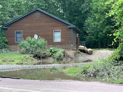
A Cambridge, Vermont home damaged by flooding last
July.  Vermont lawmakers have introduced legislation
to create a "climate superfund" to help with climate
related disasters. The money would come from 
fossil fuel businesses, who would surely sue
if this law is enacted. Lawmakers say they
are confident the bill will withstand court scrutiny.
If Vermont is a supposed refuge of sorts from climate change, why are disasters caused by this phenomenon costing us so much?"  

More importantly what are we going to do about that cost?   

The Vermont Legislature is among those asking those questions. And they have another question: Who should pay? 

Here's what VTDigger reports:

"A slew of state lawmakers - 20 out of 30 senators and 87 out of 150 representatives - are invoking a precept from kindergarten. The person who made the mess should clean it up."

The Vermont legislature is looking at you, fossil fuel industry. 

SUPERFUND

The legislations really isn't that much different from the federal pollution Superfund idea that's been running for decades. Big businesses that create hazardous waste pay for pollution cleanup. 

The climate superfund idea means we now have two companion bills, one in the Vermont House the other in the Senate, that would establish a climate change "superfund." 

Vermont Public explains how this would work:

"Companies that produced more than 1 billion metric tons of carbon dioxide equivalent between 2000 and 2019 would have to pay a share of what climate change has cost Vermont, based on how much the company contributed to global emissions during the same period." 

Environmental groups in the state have been lobbying for this sort of thing and are happy the bills have been introduced. 

There's no doubt climate change is already costing a lot of money. The big flood in July - very likely supercharged by a warming world - will end up costing Vermonters more than $1 billion, notes Vermont Public. 

Vermont Public also reminds us that a 2021 University of Vermont study estimated climate change fuels flooding in just the Lake Champlain basin could end up costing $5 billion by the end of this century.

Never mind flooding elsewhere in the state, larger storms, more wind damage, searing heat and other hazards brought on by a changing climate. 

But how much money should Vermont collect and how do we do the accounting?

The answer in the legislation is somebody will have to do some detailed and accurate accounting of the damage in Vermont due to climate change. The legislation says that somebody is Vermont State Treasurer Mike Pieciak, and the would  have to get that accounting done by 2025. 

Pieciak told Vermont Public he's excited about the task and he thinks he and his staff can gather an accounting of damages in the Green Mountain State due to climate change.  Pieciak says he expects the accounting to be airtight and able to withstand litigation.

It'll have to. 

The legislation might be a great idea, but good luck collecting the money. 

 More from VTDigger: 

"The idea is to target companies that produced fossil fuels between the start of 2000 and the end of 2019 resulting in the emission of at least one billion metric tons of greenhouse gasses. Each of those companies would be held liable for its proportion of the cost of those emissions to the state. The 'cost recovery' payments would go into the 'climate superfund' earmarked for infrastructure projects that help Vermont adapt to climate change."

Awesome! 

But it's not like the fossil fuel industry is going to start enthusiastically writing checks to the State of Vermont.

First of all, VTDigger says Vermont's governor, Phil Scott, isn't sure he's on board with this. The Republican is rather pro-business, so this idea might give him pause.

On the other hand, Scott isn't exactly enthusiastic about relying on taxpayers to fund recovery from climate disasters. He says (reasonably enough) that Vermonter are taxed enough. 

No doubt Scott is aware of this little tidbit from VTDigger: 

 "According to the ominously-named Vermont Atlas of Disaster report, the Green Mountain State ranks fifth in the nation for per-capita spending on climate disasters. And conversations among lawmakers this year make clear that Vermont taxpayers don't have much more to give."

Let's say Scott decides to sign the bill, or he vetoes it but the legislature overrides the veto. Then what?

I guarantee the businesses Vermont targets for payments would sue.  However, at least some Vermont Legislators are cautiously optimistic.

VTDigger again: 

"Rep. Martin LaLonde, D-South Burlington, who is a lawyer himself, said lawmakers 'can't judge, in the end, whether this is going to make it all the way through the court cases." Still, he said lawmakers have worked with the Vermont Attorney General's Office and legislative counsel, 'and we're all confident that we have a very good case to make.'"

Well, maybe in the lower courts. 

But I see this sort of thing making it all the way to the U.S. Supreme Court. The current makeup of that court is probably the most right wing in memory, so they won't go for it.  

Still, I have to give lawmakers credit for trying.  It's time, anyway, to keep pushing for solutions rather than just giving up. Even if the U.S. Supreme Court does prove unsympathetic. 

Meanwhile, U.S. Sen. Bernie Sanders introduced a climate superfund bill at the federal level which would act much like the Vermont idea.   Other states like Maryland, New York and Massachusetts have also introduced climate superfund bills, says Vermont Public. 

Court cases and litigation will surely postpone Vermont's climate superfund and similar plans in other states and on the national level. 

However, I doubt the push to make the fossil fuel industry pay for climate change will go away. It'll be a long slog, like the battle to make the tobacco industry pay for the harm it caused. 

Climate change is obviously an even bigger deal than the health havoc created by cigarettes. 


Tuesday, January 30, 2024

Gators Survive Just Fine In Frozen Over Ponds During Cold Wave

An alligator frozen into an icy pond. Despite appearances,
the alligator was just fine once the ice thawed. 
 One of the many pleasures of living in Vermont is, when you decide to take a nice dip in a pond or lake, or in the winter, go skating on it,  an alligator won't bother you. 

Here's something that gave me just a little bit of pause, however.

It involves alligators in a pond that froze over in Texas during a relatively intense cold wave earlier this month,  There were alligators in that pond. And it turns out, they did just fine. 

Which is worrying, because it makes me wonder whether  alligators can survive our climate changed warmer winters in Vermont just fine. 

Not really, but still. 

The local NBC affiliate in Dallas-Fort Worth gives us the scoop: 

"An alligator was seen in a recent TikTok video poking its nose through the ice in a frozen pond at Gator Country, a wildlife rescue center in Beaumont, Texas.

Yes, the gator is still very much alive. It can't regulate its temperature so it survives the icy conditions by going into a state of brumation. Think of it as the hibernation equivalent for cold-blooded reptiles."

The gatos push their noses above the ice so they can still breathe even when the pond is frozen over. As long as their snouts are above water they do just fine. 

Well, I suppose the good news during icy cold waves is the alligator is so lethargic its less likely to regard you as lunch. 

News of other frozen alligators (gatorcicles?") surfaced in North Carolina. Those gators did fine, also, when temperatures warmed in the 70s late last week. 

Video: News video of the frozen alligators. The bonus is how fun the dude is who explains the whole thing to us. Click on this link to view, or if you see the image below, click on that. 


Classic El Nino Pattern Giving Us In Vermont Break From Storms

Forecast map for next Monday shows a large
storm taking a far southern track near the
Gulf Coast and Florida. It's a common pattern
during El Nino winters. It's still unknown whether
that new storm you see in California next
Monday will track south as well. 
 A storm is about to make a cross-country journey west to east through the United States, as winter storms often do. This one will really have a southern flair to it, though.

We have a  raging El Nino going on now, which is a periodic warming of the Pacific Ocean off the west coast of South America. 

One effect this has is to force storms to often take a more southerly route than they usually do. The result is cold and wet conditions in the South, with warm and dry for the season in the northern tier of states.

Which is exactly what's setting up. 

A storm packing heavy rain will slap into the California coast by Wednesday night and Thursday. The way it looks now, the storm will cross the southern Rockies then reorganize over Texas Sunday.

From there, it looks like it will move southeastward into the Gulf of Mexico Sunday, then cross over Florida to become an oddly south nor'easter near the Bahamas early next week. Then it will head out to sea.

This is kind of a long range forecast, so things could change. But I'm impressed by how far south this thing will be.

Meanwhile, a strong ridge of high pressure is setting up over south-central Canada. That, too, is part of the El Nino pattern. It's also helping to suppress storms to the south,  at least for now.  This will ensure near record high temperature for a few days over the Upper Midwest and parts of southern Canada.

For us, in Vermont, we're on the east side of this big high pressure system, so we'll have a northwest flow of air. That will keep temperatures generally near normal, since the air coming from Canada isn't nearly as chilly as it should be this time of year.

This northwest air flow will also feed moisture-starved weather disturbances through, which means we could get some bouts of light precipitation over the next 10 days or so, but nothing dramatic. The first of those disturbances is due Thursday with some light rain and snow. (Thursday will be the mildest day of the week, hence the rain risk)

Not all these southern storms that cross the nation stay south.  

The eastern United States is a wildcard during El Nino years, since storms sometimes hit California, make it to the Gulf Coast, then turn north instead of heading to Florida.

That's what happened with those two big wind storms earlier this month.  The storms hit southern California, then made their way to somewhere near southeastern Texas.

Since the storms were so close to the Gulf of Mexico, they were able to pick up a lot of moisture an energy from those warm waters. Then those two storms turned northeastward, blasting Vermont and surrounding states with damaging winds and flooding rains.

These southern storm tracks during El Nino years often last into March or even April.  That's bad for the South.  Any of these storms no matter what the season can touch off tornadoes down there. Those twisters are even more likely by March and April as the overall atmosphere starts to warm. 

El Nino patterns can be a little depressing for us here in Vermont, too when we get toward March.  Sometimes, the southern storms follow a path just to the south of New England. Which in turn can bring us some rather snowy weather in March and April. 

It doesn't happen every time.  But in Vermont, sometimes El Nino winters don't start until we're ready for spring to start 


Monday, January 29, 2024

Hot Times Already On Earth In Just First Month Of Year

Global temperature anomalies for Sunday, January 28.
Most of the world is warm compared to normal, in
some cases record warm. Note this is temperatures
compared to the average from 1979 to 2000 a 
period when global temperatures had already
increased due to climate change. 
UPDATE FEB 1

More wild record highs have come in since this post three days ago,

The most incredible to me came in from Maple Creek, Saskatchewan on Tuesday.

The temperature there reached 70 degrees, breaking the record by a full four degrees for the
highest January temperature in that province. 

The normal high temperature this time of year in Maple Creek is in the low 20s.

Churchill, Manitoba, on the shore of Hudson Bay, reached 38 degrees. The normal high in Churchill this time of year is 5 above. 

Today, February 1, the Maldives became
the first nation or territory this year to set its all time high temperature for any day of the year. It reached 92.5 degrees.

On Wednesday, the temperature in International Falls, Minnesota, the supposed "Icebox of the Nation" set a new record high for the entire month January with a high of 53 degrees. It was the first time on record temperatures ever reached 50 degrees in International Falls. 


PREVIOUS DISCUSSION JAN. 29

We're had another really warm January here in Vermont this year,

It might not feel like it, given all the storms and ice and clouds and gloom we've had.  Chances are low that it will make the top ten warmest, but it's still much balmier than Januaries of the past.  

Meanwhile, the heat is really, really on in other parts of the globe.

Last year was the hottest on record for the Earth. Many experts are saying 2024 will be even hotter. It's less than a month  into the new year, but we're off to a good start in fulfilling that hot prophesy. We're seeing incredible warmth in almost too many spots on the Globe to count.

Throughout history, with or without climate change, there's always been weather extremes. You were always sure to find a couple spots with the warmest temperatures in memory and a couple of others that were coldest that anybody recalled. 

In the age of climate change, you still get a few instances of nasty Arctic chill. But those are far outweighed and outnumbered by the super warm spots. This winter, El Nino is supercharging that trend. 

Heat records  are being set in the United States and around the world at a dizzying pace. Even in spots that haven't seen record heat this month - like Vermont - it's still strangely warm. 

Let's start it all of in the good ole U.S. of A. 

UNITED STATES

While we in Vermont were locked in a Steven King style "Mist" on Friday, Washington DC soared to 80 degrees, their hottest temperature on record for the entire month of January. Their previous record for earliest 80 degrees of the year was on February 21, 2018. On average, Washington's first 80 of the year hits on March 28.

The dew point - a measure of how humid it feels, peaked at  66 degrees in Washington during the January heat wave. That occurred in the morning before the heat peaked. But still, the nation's capital had by Vermont standards an uncomfortably muggy July morning. 

Elsewhere, Charleston, South Carolina tied its January record, reaching 83 degrees. Other record highs included 80 degrees at Baltimore Harbor and 83 degrees in Wilmington, North Carolina. 

This national warm spell helps reverse a trend this month in which record lows in the United States were exceeding record highs. In the age of climate change, most months have more record highs than lows,

Elsewhere, record highs were reported in Washington State and Oregon Sunday, with highs of 61 in Seattle and 63 in Olympia.  Record highs in Oregon included 69 in Eugene and 66 in Salem. The near record warmth is expected to spread into the Northern Rockies, Northern Plains and Upper Midwest by middle of the week.  

 Great Falls, Montana, which bottomed out at an absolutely bitter 34 degrees below zero on January 12 and 13, begun what was expected to be five consecutive days with temperatures in the 60s starting Sunday. 

We've had several bouts of this kind of "weather whiplash" in the United States, including here in Vermont, in which whatever rare moments of record or near record cold is followed immediately by record warmth.

Weather historian Maxmiliano Herrera has - as always - been so helpful documenting these weird and frequent heat waves.  I 

Let's take a global tour and check out just part of the widespread heat Herrara has found over the past few days.   

 Europe

January, 2023 brought some of the hottest midwinter conditions ever recorded in wide swaths of Europe. Weather and climate experts were stunned by the level of winter heat last year.

Then January, 2024 hit. Herrera is calling this "the most insane event in European climatic history, beating 1-2 January, 2023."

Here's just some of the reasons he's saying this: 

The temperature reached 66.5 in Kinlochewe, Scotland Sunday, the highest January temperature on record for anywhere in the United Kingdom. It was also the hottest temperature on record for all of meteorological winter in Scotland, which runs from December 1 to February 29. There was another unconfirmed report of 68 degrees in Scotland that is being investigated. 

Dozens of cities across France reported record highs, with some towns reaching as high as a summer-like 79 degrees. 

Some summery temperatures this past week included 74 degrees in Collobrières, France and Cuenca, Spain, 64 degrees in Imst Austria and 62 degrees in Piotta, Switzerland. Andorra had its hottest January day on record with a reading of 69 degrees. 

Record highs for the month of January have also been reported in Spain. 

South America

Argentina has been having repeated bouts of heat for at least six months now.  They basically endured a year without a winter back in July and Augusts. The heat trend  is continuing this month.

Just one example: Trelew, Argentina just saw its hottest day on record with a high of 109 degrees. Surrounding nations aren't doing much better. Talca, Chile broke its all time record high temperatures last Monday, reaching 102 degrees. Peru is dealing with a record breaking heat wave this weekend. This past Monday, Talca, Chile.

Herrera noted that the most striking part of South America's recent heat is how widespread it has been. Almost all the continent has been broiling in extreme heat over the past week or more.

Africa

The high temperature this past Tuesday in Dimbokro, Ivory Coast reached 103, their hottest January day on record. It was 115 degrees in Vioolsdrif, South Africa. 

On the complete opposite end of Africa, several cities in Algeria this past week recorded their hottest January days on record. A couple cities in Tunisia did the same. 

Elsewhere

Instances of record January warmth were also reported in parts of Australia, Mexico, the Caribbean, and around the Mediterranean sea. South-central Canada looks destined to have record January heat as well as the month closes out. 

There are signs that new outbreaks of record January heat will continue as we close out the month in the next few days. I expect the same out of February at this point. 

With all the heat records being set this month,  it will be interesting to see whether January, 2024 becomes the hottest January on record for the world as a whole.

At this point, I'm betting that happens. 


Can't Escape The Vermont Freezing Drizzle; But Quiet Weather Week Ahead

You could just see a little ice on bushes and trees
yesterday morning in St. Albans, Vermont after another
night of freezing drizzle. Same issue this Monday
morning in some parts of Vermont, so be careful
on the roads during the morning commute 
 For the six day in row, parts of Vermont saw some pesky freezing drizzle this morning. 

Like in previous days, it's not much and it's patchy, but it doesn't take a lot to mess with driving. 

The freezing drizzle early today was unexpected, as the atmosphere is transitioning to one in which it is colder aloft. Under that regime, any precipitation that falls should be snow.

But the atmosphere hadn't gotten rid of a warm layer yet, so the freezing drizzle hit in spots. If there is any freezing drizzle or freezing fog still out there as I write this at 6:30 a.m. it will end soon.

The usual caveat applies: Just take it slow and easy.  Untreated surfaces here and there, like back roads, driveways, some sidewalks etc. may be quite icy.  On the highways, overpasses and bridges are more likely to have ice than the rest of the road.  It's best not to use cruise control on your car and keep a big distance between you and the vehicle in front of you. 

Meanwhile that storm system that scooted by to our south obeyed last evening's forecast updates and didn't amount to too much. 

Parts of central Vermont got three or so inches of snow. Norwich, Vermont reported 2.9 inches and East Barre clocked in with 2.8 inches. No snow reached far northern Vermont. 

High elevations of far southern Vermont, as expected got some snow, too. Athens, which is a high elevation town west of Bellows Falls, got five inches. West Arlington in southwestern Vermont saw two inches.

So, not a big deal

REST OF WEEK

Blessedly boring is still the weather outlook for this week in Vermont. Knock on wood, we have no more freezing drizzle on the way. 

We'll start the week off with near normal temperatures.  Readings near 30 this morning won't go anyway as north winds blow somewhat colder air in from Canada. 

It'll be in the upper single numbers and teens tonight, and in the 20s Tuesday.  Tomorrow brings us the best chance of seeing any sun since Monday morning, January 22.  It won't be crystal clear, but patches of blue sky could yield some sunshine. Same on Wednesday. 

Wednesday and Thursday look like they'll be on the mild side again (highs in the 30s) before a cold front brings us a chilly, but not ridiculously cold weekend to start February.  I still see no signs of any big storms until at least a week, probably more. 

Sunday, January 28, 2024

Sunday Evening Vermont Forecast Update Will Disappoint Snow Lovers

Updated National Weather Service snow prediction map. 
Predictions have been really scaled back in southern
Vermont, and this storm is increasingly looking 
underwhelming for snow loversl 
 It looks like the expected snow tonight in southern Vermont might go pfffft. 

At least to an extent.  

Meteorologists have scaled back expected snow accumulations for a reason you're going to mock: Dry air.

We've been socked in with low clouds and fog for days. So when we finally have an opportunity to squeeze some snow from all this wet air, all of a sudden we're talking about dry air?

Yep.

And said dry air is not going to solve our problems with this interminable overcast we're dealing with. 

The dry air is punching in several thousand feet overhead, up where snowflakes can form, not down here where most of us live. So the low overcast we've been oppressed by will continue. But the spot in the atmosphere than can manufacture snow flakes looks like it will falter.

As the National Weather Service office in South Burlington describes it, the mid-level dry air will probably limit snowfall. Plus, the lift in the atmosphere is not great. You want rising air to create precipitation and we have it in this situation. But it's not impressive.

The result, at least according to Sunday evening forecasts, will be an underwhelming 1.5 to 3.5 inches of snow for Vermont from Route 2 southward. I suppose a few high elevations down south could see four inches or a little more.

By winter storm standard in Vermont, that's a big yawn. 

I suppose we could still be surprised by more snow than that, given how so many storms have over-performed this winter. But I'm not holding my breath. 

Areas of Vermont north of Route 2 were never expected to get much snow and that's still true.  OK, those northern areas might get a dusting to as much as a little less than an inch of snow. But who cares? That's not exactly Blizzard of the Century. 

On the bright side, parts of far northern Vermont got a brief interval of dim sun earlier today. The sun was sort of,  kind of out in a wimpy way for a half hour late this morning in St. Albans before the dark, low clouds dominated again. 

I'll take anything I can get. 

Looking ahead, I suppose we might get some sun Tuesday and Wednesday, which would be nice. But those breathtaking clear  blue skies with white snow coating the mountains we often get this time of year is not in the cards. 

At least we're still not seeing any signs of extreme cold for the next week or so. Through next weekend temperatures will vary from about average to moderately warmer than you'd expect for this time of year 


One Last Little Vermont Storm, But Clouds Still Reign Supreme

That old familiar National Weather Service snowfall
prediction map. This time, a modest snowfall,
except maybe a decent dump in the far 
southern Green Mountains of Vermont. 
 Another day, another one with low overcast in areas of fog this Sunday morning in Vermont.

The fog wasn't as dense nor as widespread as its as Saturday morning, but the gloom for sure remains. 

We don't have any great news yet for people (like me!) yearning for sunshine, but at least the next bout of precipitation in the pipeline seems relatively harmless. It'll still cause a few issues, though. 

That comes later today and tonight, as a very west storm system passes by to our south later today and tonight. 

The further south you go in Vermont with this one, the more you'll notice it.  This will be mostly snow, but it's shaping up to be a wet snow.  In fact, it''ll be mixed with rain in southern Vermont valleys today before going over to all snow over night.  At least they're not calling for freezing rain. 

A winter storm warning is up for the high elevations of extreme southern Vermont. A good four to eight inches of wet snow is in the cards there, so I expect a few power outages.

A frozen spruce branch in St. Albans, Vermont
after frequent bouts of freezing fog and
freezing drizzle the past couple of days. 
The snow tapers off as you head north. A winter weather advisory is up for the rest of southern Vermont to an area a little north of Route 4. 

In the advisory zone, the National Weather Service in South Burlington is projecting three to six inches of wet snow, with perhaps a bit more than that in the high elevations of the Green Mountains. 

Central Vermont is kind of a wild card, with two or three inches on the table.  However, a few computer models - not the majority, though - give that area a little extra snow. 

North of Route 2, we're still expecting maybe a half inch to two inches at best. No biggie, really. 

In any event, roads will become iffy to hazardous, depending on how far south you are late this afternoon and overnight. Just to be on the safe side, if you need to get to or through southern Vermont, do it before mid-afternoon.

The storm does seem like it will linger into the Monday morning commute, so that snow will probably muck up travel, especially from Route 4 south. 

THE WEEK AHEAD

It's still looking rather quiet, but we're certainly not in for any wall to wall sunshine we've been craving. 

Temperatures through the week will stay a little above normal (Highs 28 to 38 most valleys, lows in the teens and lows 20s).  Things will probably trend somewhat colder by next weekend, but not intensely cold.  

The best chances for any sunshine are on Tuesday and Wednesday.  I'm thinking - hoping - that there might be decent intervals of sunshine both days, but it won't be absolutely clear. 

Colder weather disturbances look like they might arrive by Friday to bring us snow showers, and such by then. It's hard to say from this vantage point, but there might even be a snow squall or two thrown in the mix by then. 

However, the weather systems will be coming from the west and north, so they'll be moisture-starved. That means no big dumps of snow for us after today. At least for awhile. 


Saturday, January 27, 2024

Another Vermont Fog Attack As Gloomy Winter Continues

Crows gather on trees amid dense fog and freezing
drizzle Saturday morning in St. Albans, Vermont. 
 The murk and fog that's been plaguing Vermont this week - all winter, really - intensified last night,  blinding motorists and laying down a very thin but potentially dangerous layer of ice on some road surfaces.  

Meanwhile, far southern Vermont is under a winter storm watch. More in that further below

The dense fog advisory for all of Vermont is in effect until 10 a.m. today. Visibility in some areas was down to a mere 50 feet. If you're caught in that on the roads, you'd better be driving really slowly. It's hard to see even bright tail lights ahead under those conditions. 

I noticed some flights are late or delayed at the Patrick Leahy Burlington International Airport in South Burlington, so check your flights if you're coming in or out of Burlington today. 

Temperatures throughout the Green Mountain State started the day at around 32 degrees, so the fog was freezing on some surfaces. 

Jackson the Weather Dog encountered our icy driveway in St. Albans, Vermont when he went out early today to take observations on the dense fog and temperatures. Jackson noted a little freezing drizzle was also falling here in St. Albans, and I'm sure in several patches elsewhere in the state.

The fog is part of a national weather pattern I posted about the other day which has been socking in wide areas of the nation. Widespread fog broke records midweek for the amount of land they covered.

Traffic cam showed foggy conditions on Interstate 89 in
Georgia, Vermont this morning. 
This morning, there was slightly less fog in the nation than earlier, but it was still remarkably widespread. Especially for midwinter.

In addition to Vermont, dense fog advisories this morning covered most of the states around the western and southern Great Lakes, parts of the northern Plains and numerous spots up and down the East Coast. 

Back here in Green Mountain State, the fog should gradually become less dense as this Saturday morning wears on, but it won't entirely go away.  

We've got another gloomy day ahead of us with a thick overcast, patchy fog, dank conditions and perhaps a few little area of drizzle or a couple wet snowflakes. 

The fog will probably thicken up again tonight, but not become dense in as many areas as it was this morning. Then comes the next little troublemaker

SUNDAY SNOW

That storm we've been watching will pull northeastward out of Mississippi today, carrying boatloads of moisture with it. Flood watches today extend from Alabama to West Virginia.

The storm will move to near West Virginia by Sunday morning. At that point it will fade in favor or a new storm along the Mid-Atlantic coast. That new storm will then scoot east to northeastward away from the U.S.

Still, its projected path has nudged northward a little bit compared to previous forecasts, That puts southern Vermont in play for some snow. 

Snow forecast for Sunday/Monday from the National
Weather Service. Six inches possible in far southern
Vermont, perhaps nothing near Canadian border.
Map is subject to change by tomorrow. 

A winter storm watch has been posted for Bennington and Windham counties Sunday into Monday. Four to eight inches of snow is a decent bet there, especially in higher elevations.

This will be a wet snow, so a few power outages are a risk.

Snow amounts will diminish quickly as you head north.  The National Weather Service has storm totals of around two inches up to about Route 4, and an inch or less up to Route 2, with little or nothing near the Canadian border.

There's a HUGE caveat with that forecast, though.  If the storm track continues to nudge north, heavier snow than that will fall in southern and central Vermont. Whatever happens, Sunday will be another overcast, dreary day. 

If you're looking for a literal bright side, I have just a teeny morsel of good news. The weather during the upcoming week still looks like it will actually be boring. - a little warmer than average with no notable storms. 

However, it doesn't look like we'll be seeing much sun, either. 

Friday, January 26, 2024

Quick Friday Evening Vermont Update: Just Damp/Foggy/Icky Overnight

Traffic makes its way along Interstate 89 in Colchester,
Vermont this morning amid a cold rain, fog and gloom.
 Luckily, today's storm wasn't too, too bad. It was just an ugly winter day. 

The areas of freezing rain weren't that big, and didn't accumulate much, at least in Vermont. 

As expected, the rain changed to snow in mostly the Northeast Kingdom, and it didn't amount to much.

Most of us ended up with a miserable, cold, soaking rain. Many of us ended up with close to a half inch of rain.

The precipitation is over for the night. Except perhaps patches of drizzle, freezing drizzle or a few wet snowflakes. 

All of those winter weather advisories we had earlier have been canceled. 

For tonight, the main problems will be that seemingly ever-present fog. And patches of ice on roads, especially east of the Greens.

The bigger of the two problem will be the fog. It was already pretty dense in several spots as of 5 p.m. With light winds and lots of moisture, that fog will linger, and reduce visibility on the roads. You'll need to slow it down tonight.  

Use your low beams, not the high beams.  The high beams will blind you mostly, but also people coming the other way through the fog. 

Temperatures will fall to near freezing, so we might have issues with ice on untreated surfaces again tonight through early tomorrow. 

Saturday is looking murky.  But almost precipitation free, with just possible a patch or two of drizzle or wet snowflakes. 

That potential storm Sunday or Sunday night is still trending too far south to bother us much, but there's still an opportunity for it to curve north.  Meteorologists are monitoring trends with that one. 

After A Decade, A Climate Scientist's Defamation Suit Goes To Trial.

After 12 years, a defamation  lawsuit against provocateurs by
noted climatologist Michael Mann has finally gone
to trial.  Mann's detractors saying he's attacking free
speech, but bloggers being sued compared Mann to
 criminals and even child molesters.  
 Talk about a slow court proceeding!

Michael Mann, one of the world's most prominent climate scientist, is finally getting his day in court. This more than a decade after he filed suit against climate deniers he says defamed him. 

According to Scripps News Service:

"A renowned climate scientist filed a lawsuit against a right-wing blogger and an analyst for defamation, and after more than a decade, the trial begin on Thursday. 

Michael Mann, an earth and environmental scientist from the University of Pennsylvania, filed the 2012 court case, claiming that online attacks on his work constituted defamation."

The long running case is important because it could set parameters as to how far people and activists can go in attempting to take down a perceived enemy.  I'm very nearly a First Amendment absolutist, but I still think there needs to be limits on how badly one can lie about and attack someone.

Mann is suing Rand Simberg, an analyst at the Competitive Enterprise Institute mainly because he published a blog post comparing Man to a convicted child molester. Mann is also suing Mark Steyn, who fawningly quoted Simberg and said Mann's research was, quote, "fraudulent."

It's interesting that if you look up that blog post now, there's a disclaimer at the bottom saying "Two inappropriate sentences that originally appeared in this post have been removed by the editor."

Hmmm. 

I worry if Mann loses, the type of baseless attacks you see on social media all the time will get even worse. There's already death threats galore out there, mostly by hard right winters who wilt when somebody says something, um, factual. 

Mann's suit might have a chilling effect on those that stalk, harass, threaten and all that. But unlike critics of his legal moves, I seriously doubt it will chill real journalism in the process. 

I regard Mann as Mr. Hockey Stick for his clear, relatable explanation of world temperature trends and how climate change influenced those trends.

Way back in 1998, Mann famously plotted in a graph that showed that global temperatures remained essentially flat for the past millennium before spiking upward dramatically after 1900. His graph looks like a hockey stick with its blade upturned. 

This easy to understand graph was featured prominently in widely read and watched publications, and thus he greatly helped galvanize the public's understanding of climate change. 

Right wing climate deniers were having none of this.They screeched and yelled that global warming is a hoax and they accused Mann of illicitly manipulating data to support his conclusions.  In short, they said Mann's hockey stick was one great big fake. 

Those allegations prompted an investigation of Mann and his science by the federal Environmental Protection Agency, the National Science Foundation and seven other organizations.

When you have that many powerful groups investigating you, that could leave the public wondering if you're on the up and up. 

All the organizations that investigated Mann found that his science was solid, all of his research was properly conducted, and the facts he presented in his work were indeed facts. The hockey stick was proven to be a real thing. 

While all this was going on, groups widely believed to be backed by billionaire Charles Koch repeatedly bombarded Mann with freedom on information demands, probably in an effort to interfere with his work and/or discourage him from publishing more papers. 

The deniers were also probably pretty mad that in 2007, Mann, and with Al Gore and people with the Intergovernmental Panel on Climate Change, won the Nobel Peace Prize for establishing a consensus on the link between what us humans do and global warming. 

With the braying climate deniers still besmirching his reputation, it was Mann's turn to get pissed. As Scripps describes it:

"After his investigation included, Mann filed a lawsuit against the two organizations and two authors for defamation and intentional infliction of emotional distress."

The Competitive Enterprise Institute and the National Review publishes the right wing bloggers' attacks. But in 2021 courts ruled the CEI and National Review would be dropped from Mann's lawsuit because the bloggers were not employees of the two organizations.  

Still the people over at the National Review are still really peeved at Mann, apparently. 

The National Review had a pretty, um, rich take on the whole mess earlier this month. They're calling it "Michael Mann vs. Journalism" as if the people constantly harassing the scientists and repeatedly making false accusations were intrepid journalists from the New York Times or something. 

This quote from the National Review piece criticizing Mann's lawsuit really got my blood boiling:

"Are Americans able to disagree about hotly contested political topics without being harassed, dragged into court on the most specious of pretexts and subjected to ruinous legal fees?"

Why, yes! Yes they are! Or at leas they should be. I hardly think thousands of frivolous Freedom of Information Requests, demonstrably false accusations .... are Americans high-mindedly "disagreeing about hotly contested political topics."

After all, with all the peer reviews and such, the people Mann is suing knew, or should have known, that Mann did not falsify his research. So there's one of Mann's plausible arguments that he was defamed. Not to mention that comparison to a serial child molester. 

Funny how the extreme right wing, whenever they encounter someone politically they don't like, get the vapors and start accusing people of sexual assault and deviance.  

Sure, I'd be annoyed with Mann to say the least if he sued journalists or others for merely asking challenging questions about his work.  That comes with the territory. 

The National Review is correct in stating that First Amendment case law allows people to make vehement and caustic statements and arguments without fear of a successful lawsuit against them. But does the First Amendment allow making knowingly false statements about somebody, especially if those false statements are designed to wreck a person's reputation?

I'm not sure why it's taken so long for Mann's suit to go to trial. I mean, 12 years is a long time, even by the standards of an often slow justice system we have these days. 

I do hope Mann wins. Sure, we have the right to criticize whoever we want. Simberg could have made his case against Mann vehemently and aggressively even though he was wrong. But he took the schoolyard bully approach by resorting to false accusation of heinous crimes.   .

That's definitely a bridge too far.  


Friday Morning In Vermont: Wet And Icy As Planned

The dreaded Friday ice forecast map. Yellows depict
basically just a thin glaze.  Red is about a quarter inch
So the worst issues will be in the southern Greens today.
Remember, though, just a tiny film of ice can make
travel on roads really hazardous, so be careful out there! 
 Right on schedule, the rain moved in before dawn today, leading to what is turning out to be an unpredictable Friday morning commute. 

Depending on where you are, it's either a cold rain, or freezing rain. The cold rain is obviously unpleasant, but harmless. The freezing rain, however.....

The problem is, if you're driving along, it's impossible to tell where you're going to encounter ice and where it is just wet. 

The broad brush is there. You're less likely to see ice in the immediate Champlain Valley. And more likely to see it from the Green Mountains east.

Temperatures were right near the 32 degree mark as of 6 a.m. and likely to stay there throughout the day. So even where it's mostly rain, you might encounter pockets of ice. And where it's icy, you might find spots that are just wet.

Bottom line: Take it easy driving anywhere today. Assume you're on ice. 

As the day goes on the rain and freezing rain will transition to sleet and snow, starting in the Northeast Kingdom and moving west and south through the day. 

That's in line with previous forecasts from last night. The NEK can eventually expect one to three inches of sleet and snow today,  By the time you reach the Champlain Valley, there will only be a slushy dusting at best late this afternoon. 

The best chances of heavy accumulations of ice - enough to cause some isolated to widely scattered power outages - is still the central and southern Green Mountains.  In those spots, the freezing rain will last almost all day, and not change to any sleet or snow until the very end of the day - if at all. 

Bits of ice cling to pine trees in St. Albans, Vermont on
Thursday. More freezing rain is falling on parts of
the state today, causing areas of of hazardous
driving all day. 
Here's a weird factoid:   

Under a thick overcast, temperatures are forecast to stay strangely  uniform. The temperature in Burlington has bounced only between 32 and 36 degrees since 5 a.m. Thursday. It's forecast to stay squarely within that range until about 2 a.m. Saturday. 

If this forecast pans out, then temperatures in Burlington will have only varied by four degrees for nearly 48 hours. That's an incredibly long time for temperatures to not move much, especially  considering on average this time of year, the range is 16 degrees in just one day. 

LOOKING AHEAD

Going into Sunday the next storm is still trending too far south to give most of Vermont much snow. But there's still time for surprises, so the storm will still need to be monitored.

Other than that, the Vermont weather starting Saturday and going through next week looks blessedly boring for a change. As it looks now, temperatures will be fairly close to average overall with  no notable storms until next Friday or Saturday at the very earliest.  

Thursday, January 25, 2024

Thursday Evening Vermont Ice Update: A Little Colder, A Little Icier

Compared to forecasts we saw this morning, expected ice
accumulations depicted in this map released by the 
National Weather Service office in South Burlington 
have increased. Red areas should expect at least
a quarter inch of ice. 
 The forecast for the new round of ice, freezing rain, rain and general ick for tonight and tomorrow across Vermont and surrounding areas has gotten a little worse, I'm afraid. 

Settle in, folks, this is impossible to explain in 100 words or less, so here we go:

Cold air is being stubborn across northern and eastern Vermont, and that, I think, will make the ice a little more widespread than earlier forecasts. Not everyone will get freezing rain, but everyone will need to be on their toes.

Even in the Champlain Valley and southwestern Vermont, which I thought earlier would be mostly safe from any ice. 

The National Weather Service office in South Burlington has hoisted a winter weather advisory for all of Vermont for ice, and a little snow in spots. The advisory runs from early Friday morning until 7 p.m. or so Friday evening. 

However, some of the fun begins even before the real precipitation and ice arrive in the wee hours Friday morning. 

Cold air has been draining into the northern Champlain Valley all day. It stayed at or below freezing here in St. Albans all day amid a dense fog. Interestingly, Burlington was a little above freezing all day, but dipped to 32 degrees at 4 p.m.  

Elsewhere, most of Vermont was a little above freezing this afternoon.

We will see problems with dense fog in some areas this evening. Also, patchy freezing drizzle will make road conditions a little dicey and unpredictable in spots.  This includes areas of Vermont outside the chilly Champlain Valley, as temperatures dip slightly through the evening hours. 

FRIDAY

As the next in the series of modest but rather wet storms approaches tonight, east breezes on its northern flank looks like it wants to tug in some slightly colder air in the lower levels of the atmosphere from high pressure parked north of Maine.

This would make freezing rain more likely. 

Water droplets remained frozen solid to tree branches all
day in St. Albans, Vermont amid dense, cold fog.

The fun will start before dawn and continue through the morning commute hours. So the timing stinks. I still expect some school closings, or more likely school opening delays on Friday. 

Like the last round we had late Wednesday and early today and despite the current chill, the Champlain Valley looks marginal for rain vs. freezing rain Friday.

 I imagine it'll be patchy, with some areas fine, others icy. And temperatures there, and in some other parts of Vermont will probably fluctuate near the freezing mark during the precipitation all day Friday. 

Remember, even if it's a little above freezing, ice could still form on driveways, back roads, overpasses and deeper valleys. 

Areas from the Green Mountains east are much more likely to see freezing rain instead of rain, but even there, it might be patchy. 

Also, with temperatures so close to turning things icy, there's tremendous bust potential in the forecasts. It's possible we end up with quite a bit more ice than forecast, or quite a bit less. 

So it'll be a crap shoot as to who gets icy, who stays wet.  Just assume if you need to drive to work or school tomorrow chances are you'll encounter ice somewhere. 

At least for awhile.

IT'S COMPLICATED 

That cold air being pulled in from the east by this storm will gradually take up a thicker and thicker layer of the atmosphere. So during the day, rain or freezing rain will slowly mix with and change to a little sleet and some wet snow

That changeover process will start in the Northeast Kingdom in the morning, then spread west and somewhat south during the day. 

This is actually good news for parts of northern Vermont because it would cut down on the amount of freezing rain that will fall.  If this pans out as expected, there won't be much snow, even in the Northeast Kingdom. Up there, it'll probably amount to one to three inches. 

I'm not even sure the snow will reach the Champlain Valley. If it does, it won't amount to much.  Central Vermont will probably see an inch or less of snow.

Southern and central Vermont is least likely to see snow and sleet. Which means - if Thursday evening forecasts are correct - some areas in and near the Green Mountains from about Sugarbush south could see a good quarter inch of new ice from the freezing rain. 

Especially in spots where any ice didn't really melt today, this puts the risk of scattered power outages in play. Remember, in most ice storms, power outages begin at least on a limited basis if there's a least a quarter inch of ice. 

I still don't expect widespread power outages, but I do think there will be a few problems. 

BEYOND FRIDAY

We still have a lot of question marks about the weekend. 

Saturday looks gray, overcast, gloomy and mild. We could see some patchy wet snow here and there, but it won't amount to much. 

On Sunday, Vermont gets caught in a squeeze play.  Some colder air from Canada wants to push southward into our neck of the woods. Meanwhile, the last of a series of storms will head northeastward out of the Gulf of Mexico.

Will that storm come far enough north to give us snow later Sunday into Monday? Or will that push of cold, dry air from the north shove that storm southward and out of our hair?

It's a tossup.

At this point, southern Vermont looks most likely to see snow, with chances dwindling the further north you go.   The good news is if the Sunday/Sunday night storm comes far enough north to bother Vermont, it'll give us snow, and not freezing rain. 

Remarkably, unless there's a big surprise, it still looks like there are no subzero blasts of Arctic air in the forecast at least into early February. 

This winter's reputation continues: Not cold at all, but gawd, the weather has still been awful. 


Oddly Foggy Winter Locally In Vermont, And In Nation

Once again, dense fog obscures the forest behind my
St. Albans, Vermont home today. Dense fog has been
unusually prevalent this winter in Vermont. It has 
also been strangely widespread across
the United States this week. 
 Once again Thursday afternoon, my area around St. Albans, Vermont was encased in a cold, dense fog.

It's happened a lot this winter. It's very strange for a season in which cold, dry, gusty air usually flushes out any trace of fog.  Even on days without dense fog this winter, a low overcast and lighter fogs and haze have given us a truly gloomy winter. 

Vermont isn't the only place in the nation to have strange bouts of dense winter fog. 

The past three days have set records for the most widespread areas in the United States to fall under dense fog advisories. This morning parts or all of 27 states were under dense fog advisories. That's 100 million people who were under those fog alerts. 

Fog was widespread in other states today, too, but in those areas like in Vermont the fog wasn't dense or widespread for long lasting enough to trigger those advisories. 

Dense fog can obviously be dangerous or at best inconvenient. The Washington Post noted that a pedestrian died when they were hit by a car in dense fog in Indiana, and a Louisiana causeway was closed because of a highway pileup in the fog.

Over the past two days, fog  is mostly responsible for the cancellation of roughly 7 percent of flights at Chicago's O'Hare airport and delayed roughly 17 percent more. 

WHY IT'S HAPPENING

The vast areas of fog in the Midwest, Plains, Ohio Valley and Great Lakes had their roots in last week's cold snap. Snow covered most of this area, and the ground got quite cold, actually freezing in many of these places.

The vast gray area on this National Weather Service
map from this morning is all dense fog advisories. 
That same fire hose of moisture I talked about the other day - the one that produced severe flooding in parts of Texas, Louisiana and Mississippi - also features a much wider, broader flow of warm, moist air from the Gulf that infiltrated most the nation east of the Rockies.

That warm, wet air passing over the cold and often snow covered ground. This moist air is chilled by the cold ground, so that moisture condenses into fog.  

Strong winds that usually blow in the winter would disperse a lot of this fog. But this flow of wet air has featured just light winds 

The past few days featured the biggest fog attack of the winter in the U.S. But there were other ones around Christmas and New Year, some of which disrupted holiday travel. 

Here in Vermont, we've had frequent bouts of slow, warm, wet air flowing over us since November, hence our many days in the fog. 

This latest bout of fog should clear up toward the weekend in most places as windier, drier air makes inroads across the Lower 48. 

Dramatic Video Shows Extreme Waves Crashing Into Marshall Islands

Rogue waves crash into a U.S. Army
base in the Marshall Islands. 
Miraculously, nobody was
seriously injured or killed. 
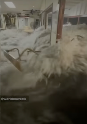
Dramatic video making the rounds shows immense rogue waves crashing into a U.S. military base in the Marshall Islands.  

Judging from the news video that you can find at the bottom of this post, I'm grateful and pleasantly surprised that nobody was killed. 

In the video, you see two people standing outside the door of what looks like some sort of lounge or restaurant. The immense wave crashes in, and the people disappear and the door gets violently smashed in. 

It looks like it hits a woman in the head as she goes under water. The water rushes into the room. Then, just when you think everybody is starting to recover, an even larger wave crashes through the open doorway and the windows.   The power goes out.

Some minor injuries were reported, but unbelievably, nobody was seriously injured. Including the woman who was hit by the door and disappeared under the water in the video.  

The waves caused lots of damage at an important U.S. military base, though. According to ABC News:

"Flooding from the waves inundated one-third of the island of Roe-Namor, located in the Kwajalein Atoll in the northern Marshall Islands, according to the U.S. Army. The U.S. Army Garrison-Kwajalein Atoll base serves as a space and missile defense test range for the U.S. Department of Defense and contains some of the Army's most sophisticated tracking equipment."

ABC continues: 

"Ocean water had washed over the northwest side of the island. Standing water was found in several buildings on the base, such as the dining facility, the chapel and a theater, the Army said, citing an initial aerial damage assessment."

 There was no particular storm to set off the big waves, though Pacific Ocean storms this time of year can make surf higher than it is other times of the year.  Also, no earthquake that would have produced a tsunami.

Instead, wave energy combined to make even bigger blasts of water from the oceans.  

A photo taken at a U.S. Army base in the Marshall Islands
after massive rogue waves swept through. 

Says ABC News:

"Jon Sienkiewicz, chief of the ocean branch for the NOAA Ocean Prediction Center, said the extreme was was much larger than the average size of the waves hitting the island's shores.

'If there are multiple wave sets, then it's possible that the energy can just double in an area from two different set of waves,' Sienkiewicz told ABC News."

The waves probably would have caused havoc and damage on the Marshall Islands even if climate change wasn't a thing. But since sea levels are higher than they used to be, waves can really penetrate onto shore much better, causing even more damage than you'd otherwise get.

The Marshall Islands are in the remote western Pacific Ocean roughly half way between Hawaii and Australia.  

Here's the video from Good Morning America. Click here to watch the video, or if you see the image below, click on that. 


The Vermont Ice And Yuck Continue

Turns out those water droplets on these branches outside
my St. Albans, Vermont house this morning were frozen,
Quite slippery underfoot, too. More rain and freezing
rain is on is way to Vermont. 
 We're midway through our rain/freezing rain/drizzle/fog mess here in Vermont and we have one more good round to go late tonight and Friday.  

There's also been some changes to the forecast which I'll get into as we go along here.

The rain and ice played out pretty much as expected last night, with western Vermont mostly avoiding the ice that made the roads slick elsewhere.

But even in what had been some ice-free spots, like here in St. Albans, the temperature fell below freezing just as the rain was ending. That left a bunch of ice on surfaces that just looked wet. Jackson the Weather Dog took a nasty tumble on the deck when he discovered this problem. (Luckily,  he's fine, just annoyed).

I did see some isolated reports of up to a quarter inch of ice in a few spots in central and northeastern Vermont, and perhaps down in Windsor County, as up to 400 homes and businesses lost power for a time down there.  

Those minimal outages pale in comparison to the tens of thousands of Vermonters who were without power in the wind storms on January 10 and 13.  

I noticed quite a few schools in around Vermont today had delayed openings because of the overnight ice.  

The winter weather advisory that was in effect has been lifted since the bulk of the rain has moved out. But I do see some new advisories in our future. 

So what's next?

TODAY

It'll be dark and overcast, of course. We'll see areas of fog, and a few light patches of drizzle with possible bits of  freezing drizzle in eastern and far northern Vermont. Slick spots will remain on the roads, especially back dirt roads overpasses, bridges and curves. 

I'd be careful driving around today, especially away from the Champlain Valley and lowlands of southwestern Vermont.  It's not going to warm up much with expected highs in the 31 to 39 degree range. So ice could remain all day in some areas.  

LATE TONIGHT/FRIDA

The next round of rain and ice come in tonight, later than it arrived last night. 

The timing of this is bad, as most of the rain and freezing rain will be coming just prior to and during the morning commute. 

Latest ice forecast for tonight and Friday from the 
National Weather Service office in South Burlington.
Looks like the central and southern Green Mountains
will get the most ice in the next round. 

Once again, the worst of the ice - or the best chance of it will be from the Green Mountains eastward, and possibly the far northern Champlain Valley.

 I expect another round of school delays or closures in Vermont Friday. I'm sure the National Weather Service in South Burlington will hoist another winter weather advisory, too. 

Ice is bad to drive on, of course, but what will make tomorrow morning tricky on the roads is it will seem like some areas will be just wet, then suddenly you encounter ice. 

One trick that doesn't always work but is still good to note:  If the road looks just wet but the vehicles in front of you are throwing up little or no spray, you're driving on ice.  Remember, though, it could be a mix of water and ice on the road, which is just as bad as plain ice

 There's been a few little changes to this forecast. But the cold air in some layers of the atmosphere will re-assert itself a little during the day Friday. Especially very roughly in the northeastern half of Vermont.

That means the rain and freezing rain could mix with or change to sleet and snow in parts of northern and northeastern Vermont.  The sleet and snow probably won't accumulate more than an inch or two. And it might be slightly beneficial in that the mix means a little less freezing rain will cling to trees and power lines. 

At this point, the best chance of another quarter inch or little more of ice is in the Green Mountains and valleys roughly near Killington and the Middlebury Snow Bowl down to high elevations east of Bennington. 

Not everybody in this region will get a lot of ice. It will be patchy, as it looks now. 

The rain, freezing rain, sleet and snow will probably last into the Friday evening commute, too. The precipitation by that point won't be coming down particularly hard. But it takes very little mixed precipitation to make the roads crappy.  

BEYOND FRIDAY

Saturday just looks cloudy and mild for the season.  I suppose there could be light, wet flurries or a few raindrops around, but nothing to get excited about. 

Sunday might feature some light snow, especially south. We're still watching a new storm that looks like it will scoot to far south to give us any major snows.  But an unexpected shift north could change that, so we'll keep an eye on it. 

We'll probably see a quick shot of cold air early in the week (Highs 15-22, lows in the single numbers) before it gets rather mild again by midweek. 


Wednesday, January 24, 2024

Wednesday Evening Vermont Ice/Rain Update: UG-LEE

Forecasted amounts of ice for tonight and early 
tomorrow have ticked up somewhat. Red areas can
expect a quarter inch of ice. This could be enough
for isolated power outage. Whether or not the
power stays on, road conditions in the yellow
orange and red shaded areas will be 
terrible overnight and early Thursday. 
We entered today into what I consider the worst or at best, the very least pleasant stretch of weather in Vermont this winter.   

That's saying something, considering how stormy it's been since late November.  

As I said this morning, I hope you like rain, freezing rain, drizzle, freezing rain and fog/freezing fog. 

Sun is a distant memory. We haven't seen it since Monday morning, and we won't see it again until Sunday at the earliest. But more likely not until Monday. 

The storminess we're entering into isn't the strongest of the winter. But it's the ugliest.  

This afternoon, temperatures did manage to get above freezing in much of western Vermont, but it still was a lousy day with low, gray clouds, an unpleasant south breeze, and patchy fog and drizzle. 

 A warm front of sorts has passed through western Vermont, but has stalled out before reaching far northern and much of eastern Vermont.

As a result, much of central and eastern Vermont held near or a bit below freezing. 

Both these facts kind of spell out our future tonight into Saturday night.  Before we get into it, since temperatures will be so close to the freezing mark, some of what I outline might end up being a little off. Some areas might get a bit more ice than expected, others might see a little less. 

But less slide on into the forecast: 

TONIGHT

The air has warmed up aloft quite a bit since this morning. So a new area of precipitation that was just entering our area as of 5 p.m. is pretty much all rain.  Not snow like this morning. 

But the low level cold air is hanging tough along and east of the Greens. That means it will be mostly freezing rain overnight in those place. I don't recommend driving anywhere in those areas from about now (5:30 p.m. Wednesday) to Thursday morning. 

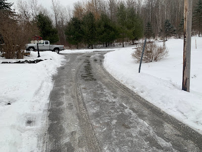
Parts of my St. Albans, Vermont driveway thawed today,
while other parts remained solidly frozen. A cold
rain tonight will likely add to the ice, despite
temperatures expected to be marginally above freezing

Forecast rainfall amounts have also ticked up since this morning. That makes me wonder whether power outages will be an issue in parts of eastern Vermont.  I don't think it will be anywhere near as extensive as during those awful wind storms on January 10 and 13. 

But a quarter inch of ice accumulation is where tree branches and power lines start to have trouble. Some areas in eastern Vermont will have that much. 

On the bright side, widespread power outages usually don't start happening unless there's more than a half inch of ice, and that isn't in the forecast through Thursday morning. 

In western Vermont, enough cold air might bleed in from the north tonight to make parts of Franklin County pretty icy.  Even if it stays above freezing, the rain will freeze on cold surfaces that aren't treated with salt. I'm talking back roads, driveways, sidewalks, that sort of thing.

I noticed today at my place in St Albans, Vermont, parts of my driveway thawed, while the ice has hung on stubbornly in other sections. We don't salt our driveway, because that would hurt the paws of Jackson the Weather Dog. My driveway is just an example of how things will play out tonight. 

THURSDAY 

Another lousy day in Vermont. The main batch of rain and freezing rain will move out by dawn or shortly thereafter.

That will leave us under a layer of low, thick clouds. We'll have areas of fog and patchy drizzle and freezing drizzle. If you have Seasonal Affective Disorder,  this will be another tough one. 

Especially since another round of rain and freezing rain will be on our doorstep. 

THURSDAY NIGHT/FRIDAY

That will come in overnight Thursday night and last well into Friday.  I suspect the freezing rain won't be quite as widespread as tonight but that's not a guarantee. I still worry about a few places that don't thaw out Thursday, then get more freezing rain Friday.

Friday will be another day of low clouds, fog, drizzle and light rain and/or freezing rain. In some placed all that will keep freezing.  Where it remains above freezing it'll only be in the mid 30s. That's quite warm for this time of year, but bone chilling given the fog and drizzle.

BEYOND FRIDAY

It'll stay mild Saturday and maybe into Sunday, but the clouds will hang tough. We're still watching yet another storm later Sunday. So far, it's still looking like that one will stay too far south to give us much precipitation. Even if it does, the atmosphere will have cooled enough to give us snow, not freezing rain. 

Cross your fingers but longer range forecasts indicate we just might have a quiet weather week next week. Sometimes boring weather is a good thing.