 |
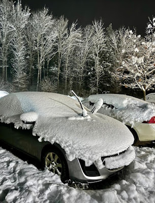
| While most of Vermont got virtually no snow on New Year's Eve, a small pocket near Stowe and Waterbury mysteriously received several inches. Photo via Facebook, Scott Brazen/NWS Burlington |
Remember how I told you on the afternoon of New Year's Eve that things would be great on Vermont roads? All we had to worry about was a few flurries and a low overcast.
That forecast proved true for probably 99 percent of Vermont.
But a small area along the lower reaches of Route 108 in Stowe, part of Route 100 between Waterbury and Stowe, and a small section of Interstate 89 in Waterbury got a snowstorm New Year's Eve.
During the day and into the night, that tiny area received up to six, seven, eight inches of snow. The snow just kept falling all afternoon and most of the night.
The roads in this little zone were snow covered and slippery. Meanwhile, just a few miles up the road in any direction from this snow zone, it was just flurries with pretty much bare ground.
So what happened?
I have no idea. This tiny little snowstorm has Vermont meteorologists scratching their heads. This was a weird one.
On New Year's Eve, there was a northwest flow of air, which had a bit of moisture in it. Often in the winter, that situation unloads a few inches of snow on the western slopes of the Green Mountains. The slopes force the air to rise. The rising air cools, moisture condenses and that can lead to that snow on the western slopes. It's very common in Vermont.
But on New Year's Eve, the condition were not quite right for western slope snow. Those areas all received just a half inch of snow or less.
Now, the theory of what happened around Stowe needs you to imagine a submerged boulder in a fast-flowing river. The rushing water goes up and over the boulder. And then there's a series of waves below the boulder, sort of echoes of the initial wave. The waves all stay in one place, so they're called standing waves.
Mount Mansfield and the rest of the Green Mountains were doing the same thing as that submerged boulder in the river.
The air having reached the summit, flowed down the eastern slopes of the Green Mountains. Sinking air usually helps prevent rain or snow, so it's not surprising the immediate eastern slopes of the mountains weren't getting much snow. The ski runs at Mount Mansfield Resort were barely dusted.
Once past those eastern slopes, the air began rising again, the first of those downstream waves. Remember, rising air helps create snow.
But, if the northwest wind's first encounter with the western slopes of the Green Mountains manufactured almost no snow, how did the snow develop at the down stream wave in the air? And why just in that spot and not elsewhere?
My best guess - and it's only a guess - is convergence. Perhaps the terrain in that spot squeezed the air from either side, funneling it into a narrow space. Maybe the combination of rising air, and that rising air being compressed from either side was enough to produce snow?
Under the right conditions, convergence can really boost snow totals. Burlington's greatest snowstorm, 33.1 inches, on January 3, 2010. Most of Vermont just had a moderate snowstorm that day, the usual six to 12 inches in most areas.
But in Burlington, moist north winds coming from Quebec got squeezed between the Adirondacks and the Green Mountains. That added to lift in the atmosphere so it snowed like hell. (Also, moisture off of Lake Champlain helped boost the snow that day, too).
By the way, the Stowe-area mini-storm might not have been the only one in Vermont on New Year's Eve. There was a report from Victory, in the Northeast Kingdom, of a local spot with up to six inches of snow, with nothing just two miles away from that location.

No comments:
Post a Comment