Friday, December 31, 2021

Messy Vermont Weekend, Update Forecast

The latest snow prediction map from the National Weather
Service in South Burlington, Vermont has three or more inches
over far northwestern Vermont after some ice, but much
less at points further south. 

 There's lots of murky New Year's Eve weather up and down the East Coast today, certainly including Vermont. In the Green Mountain State, those foggy, drizzly, damp and dark through your New Year's Eve celebrations tonight, and through the day tomorrow as well.  

At least temperatures for now are pretty far above normal, especially at night. 

It's Saturday and Sunday we still have to worry about. 

An at least temporary change to colder, more wintry weather is sweeping across the nation from west to east, and we in Vermont will eventually get to "enjoy" that. 

Snow is falling on the terrible fire zone in Colorado this afternoon.  Winter storm warnings are up for a broad area in the middle of the nation from Colorado to Illinois. A broad area from eastern Oklahoma through the Ozarks and onto Kentucky, Tennessee and West Virginia are bracing for floods Saturday. 

Some of those floods look like they might be pretty substantial, and will include the area hit hardest by December tornadoes.

We also have a risk of tornadoes in the Southeast Saturday. 

It appears 2022 wants to start off the way most of 2021 was - filled with weather and climate disasters. 

For Vermonters, the New Year won't get off to nearly as dire a start, but you'll still want to pay attention.  The caveat that's been in place remains: This is a tricky forecast, and subject to change. 

It's been warm in the East and South for the past couple
of weeks. Believe it or not, I took this shot of a lovely 
flower in bloom on New Year's Eve in a Chick Fil A 
parking lot in southern Delaware. 

The weather models have trended colder with storm, but the scenario is similar to previous forecasts. Light rain Saturday evening will change to freezing rain, then to sleet then to snow, going northwest to southeast across Vermont. 

The bulk of the moisture will be departing by the time the snow reaches southeastern Vermont, so they'll get the least.

At this point - subject to change - far northwest Vermont will get a glaze of ice followed by three or four inches of snow Saturday night and Sunday. The rest of northern and central Vermont is in for that glaze followed by one to three inches of snow. Southern Vermont gets ice, but little snow.

Like the Christmas ice, there won't be a lot of problems with fallen trees and power lines. But I guarantee some real problems with the roads Saturday night and Sunday.

I'll get an update up on this tomorrow morning. Happy New Year! 

Colorado Fire Ends The Year With Yet Another Climate Calamity

Destructive wildfires loom over Christmas decorations
Thursday in Colorado.
 Fires were calming down near Boulder, Colorado this morning as winds slackened, temperatures plunged and snow got ready to move in, but the damage is done.  

At least 580 homes, plus other buildings burned in yesterday's fast moving wildfire near Boulder, mostly in the relatively affluent and densely populated towns of Louisville and Superior.

 There was no way to stop the flames. Winds gusted as high as 110 mph.  The flames advanced the length of a football field in a few seconds.

Like many of this year's disasters, this one is especially notable for its speed and surprise.  Forecasters had warned the public ahead of time about strong winds and dry conditions, but this intense fire appeared to take everyone by surprise.

I worry not everybody was able to get out in time, and they might find bodies in the rubble today. I hope not.

Upwards of 30,000 people had to be evacuated ahead of the fires. Local news outlets are calling this fire the most destructive in Colorado history. 

Once again, like we've seen so often in the past year, scenes out of Colorado were like a wild disaster movie, but were all too real.

One clip showed a Costco being evacuated, as shoppers hastily left the building into a parking lot filled with fast moving, blinding smoke, sirens and chaos. An Associated Press video showed spot fires rapidly starting in ornamental bushes and plastic trash cans in one neighborhood amid the intense winds and smoke. Photos bizarrely showed festive Christmas decorations in the foreground, with flames ripping through homes behind them. 

Strong winds coming off the Front Range of the Rockies are not that odd, though Thursday's winds were more intense than usual. What was odd was the drought conditions, and the lack of snow so far this year.

Usually when these powerful winds develop near Boulder or Denver this time of year, there's snow on the ground, or the snow just melted in the warm winds. That leaves relatively wet ground and little chance of fires gaining too much ground.  

Passengers on flights leaving Denver airport
saw this apocalyptic scene below them.

Climate change has shifting the equation, and it seems these out of season fires are here to stay as a result. Note that the extreme fire that destroyed Paradise, California started on November 8, 2018, at a time when the rainy season should have been beginning in northern California.

The destructive fire around Gatlinburg, Tennessee on November 28, 2016 was also incredibly late in the season for the region.  That fire, like the one in Boulder, burned in intense winds just ahead of a cold front. 

More weather havoc appears to be on the way today elsewhere in the nation.  In a band through and south of the Ohio Valley, considerable flooding is on tap today and tomorrow.  

Strangely humid, warm air for this time of year will interact with a cold front, causing torrential rainfall. The flood danger zone includes areas most affected by late season tornadoes on December 10.

More tornadoes also seem likely today and tonight in Alabama, Mississippi and Georgia in the exceptionally summer-like air.

Though tornado outbreaks do occur in the South this time of year, the frequency and intensity of tornadoes in the United States in December has been off the charts.  Climate change seems to have had a hand in that, too.  The Gulf of Mexico is at record warm levels, and that's feeding the storms and enabling them to spin off more tornadoes and torrential rains.

Fire videos:

Click on on the hyperlinks if you don't seem them on the page:

The Denver Channel gives a horrifying overview:


In what looks like a scene from a disaster movie, a Costco is being hastily evacuated as the fire closes in: 


Here's the awful view a passenger on a United flight passing over the fire scene saw:


Thursday, December 30, 2021

BREAKING: Colorado Wildfire Burns At Least 500 Homes

Just a couple of the hundreds of homes going up in flames
near Boulder, Colorado today 
 A terrible winter wildfire was sweeping through neighborhoods in and near Boulder Colorado, prompting mass evacuations and burning more than 500 homes - so far.  

The area involved is in drought and has had almost no snow so far this winter.  Downslope winds of 70 to 90 mph are fanning the flames, leading to the disaster. 

 There's no word on any fatalities yet, but I worry some are inevitable, given how quickly flames spread in the intense winds. 

Wildfires sometimes happen during the winter in the Plains east of the Colorado Rockies even in winter. But nothing on this scale. This might be the worst wildfire in Colorado history.

As I write this Thursday evening, the fires continued to chew through densely populated neighborhoods.

It is supposed to snow in Boulder tomorrow, finally, but that will be too little, too late.  I'm going to pin the blame on this partly on climate change.  The high winds this time of year are common in the Boulder area. But the snow-free conditions and drought are ot. 

I"ll have more on this in Friday's post. 


The Kind Of Civil Unrest I Love, Weather Related

A "riot" during record heat on Christmas Day in western
Australia was quelled by spray from firehoses and police
armed with water balloons. 
 A record heat wave struck western Australia over Christmas, bringing temperatures of 117 degrees to the town of Karattha.  

Heat waves can bring out the beast in people.  Seems like there's often civil unrest during hot spells. 

So it was in Karattha. 

It had all the hallmarks of those riots we see on the news.  A firetruck blasting crowds with water cannons.  Residents hurling objects at police, who cowered behind riot shields while counterattacking with thrown objects of their own. 

In this case, fortunately, the water cannons were gentle, the objects thrown by the "rioters" were water balloons, and the police were not firing rubber bullets. They had their own stash of water balloons.

Following is the video.  As often is the case, mobile phone users might not be able to view the video on this page, so click this hyperlink.

Otherwise, to best view the video, click on the arrow and then the YouTube logo:


Another Messy Holiday Weekend In Vermont?

 Most of the Northeast and Mid-Atlantic Coast is incredibly murky this morning. Down where I am in temporarily in Bethany Beach, Delaware, it's damp but warm for this time of year, foggy, drizzly but still OK. 

Traffic cam of Interstate 89 in Milton this morning nicely
depicts just how gloomy it is in Vermont.  Not much
improvement is in the immediate forecast.
Back up in Vermont, people there know it's also murky but colder, with fog, freezing fog, a low overcast and general chilly but not frigid gloominess. Sun lovers want to hibernate.  

This state of affairs will continue through New Year's Eve, but at least it's not super cold, or super stormy.

However, my fellow Vermonters look like they will be subjected to freezing rain, ice and blech and schmutz for the second holiday weekend in a row.

At least New Year's Eve is looking fairly safe for travel at this point.

Details are still sketchy on exactly what will come down, but the broad brush is this: A storm system will pass over or very near Vermont Saturday and Sunday.  Depending on its track, we'll get rain, freezing rain, sleet and probably a little snow.

Who gets what and when is still a big open question. Current forecasts have rain on Saturday, but maybe freezing rain north.  It could be anything coming out of the sky on Saturday night and Sunday morning before a sharp cold front Sunday afternoon convincingly turns everything to light snow showers.

Current forecasts have the worst weather Saturday night.  This won't be an epic storm, but is shaping up to be a messy one.  Check back tomorrow for more details, as the National Weather Service and other meteorologists will have to refine and probably change the forecast. 

At this point, the long-advertised turn to typically Vermont style frigid weather is still on schedule, but probably won't last all that long.

After highs in the teens and lows near 0 Monday night, forecasts are trending toward near and above normal temperatures again by the middle of next week. 

Wednesday, December 29, 2021

United States Weird Weather Of 2021: Things Really Got Out Of Hand

Middlebury, Vermont made the cut in the Weather Channel's
list of weirdest national weather of 2021. A tornado
struck the town on March 26, severely damaging this
home. It's the only known March tornado to have
occurred in Vermont 
The Weather Channel in one of their year end reviews, highlights a list of what they view were the weirdest weather events of the year.

They had plenty to pick from this year, with the weather so often off the rails, due largely to climate change.

Most of the weird list includes odd warm and hot spells and strange storms in places that aren't used to such things. 

 Vermont made the Weather Channel's list of weird weather. They highlighted that tornado that struck Middlebury in March.  Tornadoes are rare in Vermont and they're completely unheard of in March in the Green Mountain State. At least until now, I guess. 

Speaking of tornadoes, New Jersey seems to be the nation's new Tornado Alley. Thirteen tornadoes have been confirmed in New Jersey this year, as opposed to the annual average of one or two.

Wildfires loomed large in the headlines during 2021. Among the weirdest moments was a photo of a snow making machine going full blast at a ski resort called Sierra at Tahoe resort in August. They were not trying to get an early jump on the ski season.

It was a desperate attempt to wet the ground and increase the humidity in the air as a huge wildfire approached the resort.  Between the snow making machines, firefighter efforts and luck, the resort survived the fire.  

In other smoky news, a huge area of Siberia was on fire this summer, something that has become increasingly common.  But for maybe the first time in recorded history, smoke from the fires went right over the North Pole in August.  

Snowmaking equipment was pressed into service this 
summer at a Nevada ski resort to battle huge wildfires in
the region.  Photo by Josh Edelson/AFP via 
Getty Images.

NASA scientists can't absolutely confirm this is the first time it happened, it does seem to be the first time this has been caught on satellite imagery. 

The Weather Channel says another wildfire in British Columbia generated an enormous thunderstorm the size of Georgia

The updrafts from the intense heat and smoke of wildfires sometimes generate clouds known as pyrocumulonimbus, which is a thunderstorm generated by those updrafts. These are dangerous because they produce erratic winds that spread the wildfire beneath it. The lightning spitting out of these pyro-clouds start new fires.

This one was arguably the worst fire-generated thunderstorm on record. It yielded 113,000 cloud to lighting bolts, which is 5 percent of Canada's normal yearly total. That's impressive, as thousands of thunderstorms form in the vast landscape of Canada each year.

There was also strange heat in places we wouldn't expect. We know about British Columbia and the Pacific Northwest in June. But how about this? It was100 degrees in North Dakota. At the end of September. 

It does sometimes get to 100 degrees in that northern state in the middle of summer. But it certainly has never happened on September 28. Until this year. It got up to 100 degrees in Dickenson and Watford.

The other odd heat wasn't that hot, but certainly bizarre for the location.  The top of Greenland's ice sheet is more than 10,000 feet above sea level and is always frigid.  

Ice core data indicates it had never been above freezing at Summit from at least the late 1800s to 1995, when it briefly got above freezing. Other brief thaws happened in 2012 and 2019. But rain had never been seen there.

Until August 14, when it rained at Summit Station and stayed above freezing for nine hours.  If all that isn't a disconcerting  sign of climate change I don't know what is. 

In other warm weather news, cherry blossoms in Kyoto, Japan bloomed the earliest in the season in at least 1,200 years. 

And one final small weird moment: Near Madison, Wisconsin in September, small hail that resembled donuts or more accurately Cheerios turned up. 

Pattern Change To Unleash More Severe Weather In South ; Vermont To Stay (Mostly) Even Keeled

It looked stormy, but really wasn't amid balmy conditions
Tuesday in Bethany Beach, Delaware.  A change in 
the weather pattern will rout the springlike conditions
from most of the U.S over the New Year's weekend.
This could trigger severe weather in the South.
 The summer in winter that has engulfed the southeastern third of the nation for over a week now will finally come to an end as we ring in the new year, but not before yet another severe weather outbreak or two threatens the South.  

For those in my home base in Vermont, the upcoming pattern change is set to be much less dramatic, as we're not that off the rails to begin with.  

We'll go from weather that's a little warmer than normal to conditions that are a little cooler than normal. But nothing we haven't seen before. More on that further down in this post. 

Record highs condition to fall across the South, and will continue to do so through New Year's Eve. (On the edge of the southern heat, it was a very balmy 60 degrees or so at my temporary perch in Bethany Beach, Delaware).

The northwestern United States will remain cold for the next several days.

The change is coming as the big dip in the jet stream responsible for the cold and winter storms in the West shifts east, pushes east across the United States through New Year's Day.  That will put winter back into the picture coast to coast, though of course it won't be so bad in the South.

Severe storms, including tornadoes, seem likely in the 
south today, especially in areas shaded in yellow 
and orange. 
What will be bad in the South is what will occur during the change.  Incredible warmth and humidity for this time of year  has pooled in the Southeast.  When the cold air arrives to rout the summer air, severe storms and tornadoes are a good bet.

An initial disturbance - sort of a sentinel of the impending weather pattern change - will cross the middle of the nation today.  Swaths of the South, especially northern Alabama and Mississippi and southern Tennessee, are under the gun later today for severe storms and probably a few tornadoes.

That will cap off a December with a record number of tornadoes.  

Once the main push of cold air starts to make its move, another outbreak of severe storms and tornadoes seems a good bet in the Southeast New Year's Eve and New Year's Day.

VERMONT IMPACTS

Vermont will continue to muddle through mostly cloudy weather and temperatures on the warm side for this time of year. Nothing anywhere near record breaking, but still on the mild side.

As the National Weather Service office in South Burlington notes, the pattern change will carry a storm system that will probably pass over or very near Vermont over the weekend.

Depending upon whether it goes a little north or a little south, we will either see mostly mixed precipitation or mostly rain, unfortunately. Forecasters will need to get a better handle on the storm's expected path in the next couple of days before we can get a more solid forecast.

What's clear is true winter air will rush in starting Sunday and continuing into the first half of the first week of the New Year.  This won't be extreme by any stretch of the imagination, but I can see some areas staying in the teens for highs early next week, with some below zero temperatures popping up at night. 


Tuesday, December 28, 2021

Cool, Classic Gravity Waves Over Delaware Coast Monday

Clouds showing well defined gravity waves over
Bethany Beach, Delaware on Monday. 
 I'm on a getaway and spending a few days on the Delaware coast. We arrived in Bethany Beach Monday under gray skies that spit bits of rain.  

But even the gloomy sky was interesting.

A warm front to the south Delaware set up what are known as gravity waves in the atmosphere. Winds aloft from the south were forced to ride up and over the warm front, which sort of acted as a block to the wind flow.

The set up was kind of like how water flows over a submerged rock in a fast-flowing river. Have you ever noticed when the water in that river flows over that rock, there's a series of waves in the water that continue well past the rock?

The rock set up that series of repeating waves. A blockage in the atmosphere, be it a mountain or a weather front, can do the same thing. So you have waves in sky, Up where we live in Vermont, gravity waves are very common as air flows over mountains. 

The gravity waves I saw in Bethany Beach were a little different than I'm used to seeing because the space between the peaks and valleys of the waves, so to speak, was longer than what I see in mountainous Vermont. The Bethany Beach sky wasn't super unusual, but new to me. 

By the way,the air has to be rather stable in general to support gravity waves. By stable, I mean the temperature in the atmosphere does not increase very fast with height, or at all. If the air were unstable, with temperatures cooling quickly with height, there wouldn't be waves. As the air starts to go up over the blockage, it would keep going up instead of sinking again.  In that case, you'd end up with a band of showers and thunderstorms.

The warm front ended up going through, leaving us in Bethany Beach to enjoy a partly sunny, unseasonably warm Tuesday.

Here's the video of those neat gravity wave skies over coastal Delaware. As always, many people on mobile devices will need to click on this hyperlink to see it. To see the video clearly, click on the arrow, then the YouTube logo. 

Otherwise, here's the video:


Extremes: The Weather Is Broken In Alaska

Temperature extremes this week in North America
have led to some bizarre weather in Alaska
As you can see in this map, there's record warmth
in Alaska the central United States and northeastern
Canada with record cold in southwestern Canada
and parts of the northwestern United States.
 Alaska is a land of weather extremes.  In the middle of the state, it can be 60 below in February and 90 in February.  Massive storms rake the coasts. The mountains down by Juneau can collect unbelievable amounts of rain and snow. 

But what's been going on lately is ridiculously off the rails.  I mentioned a hint of it yesterday, when I discovered a report of a temperature of 8 degrees in Tanana with freezing rain falling. 

It got even more bizarre in this vast northern state Monday.  Kodiak, Alaska, on an island in the western Gulf of Alaska southwest of the mainland, reached 65 degrees on Monday. 

It was easily the hottest temperature ever recorded in Alaska in December. Moreover, according to the National Weather Service office in Anchorage, it was the hottest temperature on record in Alaska for any date between October 5 and April 21.  Which means it was the hottest on record for not only December, but November, January, February and March as well. 

Kodiak's high temperature broke the record high for the date by 20 degrees. Which is a lot. It's equivalent to temperatures in the upper 70s in Burlington this time of year. Which is impossible. I hope. Most record highs this time of year in Vermont are in the upper 50s.

Meanwhile, deep in the interior of Alaska, Fairbanks is normally a very cold, dry place this time of year. Temperatures this time of year are often all over the place, but it's mostly very dry, with just little bits of snow here and there falling down during the winter. 

Not this year.  On Sunday, Fairbanks was slammed with tons of freezing rain and snow. If you melted down all that ice and snow, you got 1.93 inches of water, which was easily the wettest December day on record up there, and the third wettest for any time of the year. Precipitation for the month up there is 4.75 inches, the most on record for December. Normal precipitation for the month is around a half inch. 

Temperatures were in record territory in Fairbanks, too, with highs around 40 degrees the past few days.  The warmth in Alaska is coming after an especially frigid November and December, even by that state's standards. 

Alaska's extremes are coming as incredible temperature anomalies are occurring across almost all of North America. Record warmth is happening in Alaska, a vast stretch of central and eastern United States and in northeastern Canada. Record lows and brutal winter storms are hitting southwestern Canada and the northwestern United States.

(Vermont is one or the few places in North America where temperatures are fairly close to normal).

The extreme warmth does cover an area much larger than the extreme cold, even if that patch of cold in southwest Canada is record setting.  I'm pretty sure this bizarre weather week is brought to us in part by climate change.

The temperature extremes are contributing to a near record fast west to east jet stream over the United States. Flights from Los Angeles bound for New York are landing way earlier on the East Coast than scheduled as a result. 

Monday, December 27, 2021

National Weather Off The Rails Again; Record Heat, Big PAC NW Winter Storms, Fires And More.

Photo looks a bit like April in Vermont, but it was a 
springlike Frederick, Maryland on Sunday, where
temperatures were in the upper 50s under bright
blue skies. Maryland was on the edge of 
some record heat engulfing the southern U.S 
 In the grand scheme of things, the weather in Vermont this week is kind of boring.  The Christmas Day ice notwithstanding, the rest of this week will feature temperatures not incredibly far from normal, and any oncoming bits of snow or rain or mix  don't look too far off into bizarro world.  

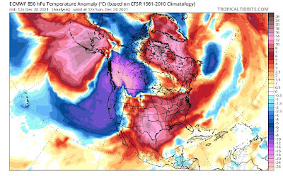
Vermont's "boring" weather this week is a big exception to a national rule. I'm writing this from my temporary perch, for today in Frederick, Maryland.

Yesterday, Boxing Day was a gorgeous spring day here in Maryland.. Plenty of sunshine, temperatures well up into the 50s, the day after it was in the 60s. In Frederick, I saw a bush on one street here with lovely new pink blossoms, buzzing with bees.

Normally this time of year, it's barely 40 degrees during the day.

Frederick, Maryland was not even close to the most extreme weather the nation has been seeing the past few days. 

Hot, frigid, stormy, fiery, windy, snowy, icy, you name it. It's there. We have some huge contrasts going on in the nation as we close out the year 2021.

Let's start with heat, since it covers such a big chunk of the nation. 

On Christmas Eve, Wichita Falls, in northern Texas reached 91 degrees, that city's hottest December reading on record. 

Video from Live Storm Media showed strong winds causing minor structural damage and filling the air with thick dust around Amarillo, Texas. Winds there gusted to at least 56 mph on Christmas Eve.

Record highs continued in Texas on Christmas Day and yesterday. This heat was punctuated by a new round of odd winter wildfires that extended on up into eastern Colorado.  Most of Colorado should be a chilly snowscape this time of year.  At least Colorado's mountains and ski areas managed to get some snow Sunday. 

On Christmas Day, record high temperatures were spread far and wide. Records included 86 degrees in Abilene, Texas, 67 in Cincinnati, 74 in Paducah, Kentucky, and 72 in Evansville, Indiana.

In Rio Grande Village, Texas on Christmas Day, it was reportedly 96 degrees. If that reading is verified, it will be the record for the hottest Christmas Day on record anywhere in the Lower 48. 

Down in Houston, it's been in the 80s thirteen times so far this month, and each of the closing days of this month should also reach 80 degrees there. This will easily be that city's hottest December on record. Normal highs in Houston this time of year are in the low to mid 60s.

It's not just Houston. After four record December heat waves in the Midwest and South, many cities in the United States look assured of having their warmest December on record.

This is in huge contrast to the Pacific Northwest and British Columbia, which are in the grips of a pretty intense - at least for them - spell of winter weather.

In a rare moment for the region. the field had to be cleared for a Seattle Seahawks Sunday to prepare for a game with the Chicago Bears. At least the Bears should have been ready for winter conditions. They did manage to squeak out a 25-24 win over the Seahawks. 

In California, snowfall in recent days measured in feet, not inches.  Many roads through the Sierra Nevada range, including Interstate 80, had to close due to the deep snow.  Donner Pass has had 119 inches of snow so far this month. The record for December there is 179 inches.  It's supposed to keep snowing there for the next couple of days, so that record could be challenged.

The Sierra snow is mostly good news, though, because until mid-month, snow cover was well below normal there. Now, it's a little above normal, which could help dent California's drought. 

Those winter storms and cold are extending as far east as Lake Superior in the northern tier of states. Blizzard warnings are up for North Dakota today.  Though temperatures are well below normal from Washington to Minnesota, there aren't that many record low temperature records being set. Not nearly as many as the heat records further south and east, anyway.

Some of this cold air in the Northwest will be on the move to the east, which could easily cause another round of dangerous weather in the South. 

The unseasonable, record heat in the South, combined with rising humidity, risks causing another outbreak of severe storms and tornadoes in the upcoming week. The cold air approaching might well be the spark that sets off those storms on Wednesday.  Another round of severe storms seems possible New Years Day before the cold air finally takes over. 

This in a December that has already broken the record for the most tornadoes for the month.

The weirdness extends up into Alaska.  At one point Sunday Tanana, in normally frigid central Alaska reported freezing rain with a temperature of 8 degrees. I don't think I've ever seen rain fall at such a low temperature.

For us Vermonters, the Green Mountain State seems to be escaping most if not all of the nation's weather drama.  Several small disturbances will zip on by this week. 

As the warm weather pattern in the South and Southeast breaks down this weekend and early next week, that might spin up a fairly substantial storm that could give Vermont a pretty good dose of snow rain or schmutz by Sunday and Monday.  

Sunday, December 26, 2021

National Weather Service Office In Sacramento Needn't Have Apologized For Donner Pass Tweet

As this graphic from Fox Weather shows, TONS of snow are
in the forecast for California's Sierra Nevada range.
The National Weather Service office in Sacramento tweeted
 a Donner Party joke about the situation, but needn't
have apologized. 
 It's been snowing like crazy the last few days in California's Sierra Nevada mountains. Plenty more is on the way. 

Yay!  

Great for skiers, great for putting a dent in California's drought, what's not to love?

Well, Christmas week travel through those mountains could get tricky. So the National Weather Service office in Sacramento, California decided to warn people by posting this tweet:


The Donner Party, of course, were 81 people who became stranded in the Sierra Nevada in the winter of 1846-47 and resorted to cannibalism to stay alive as much of the party died of cold and starvation. 

NWS Sacramento soon followed up with a mea culpa:

"We apologize for the reference on this post which was insensitive. The main message for the upcoming week is that multiple rounds of heavy mountain snow will make for difficult holiday travel. Please stay up to date on the latest forecast and alter travel as necessary."

OK, sure they went back to being serious scientists, but the apology was totally unnecessary.   The original Donner Party tweet was funny, and effectively captured the public's attention about the dangerous travel far more than a dry just the facts ma'am statement would have. 

Lots of people on Twitter agree.

Some comments on Twitter: 

"This is what happens when the tweet boss takes the week off for Christmas, or perhaps when tweets are created at the office Christmas Party," said @RealGaryMcMahon.

Here's a tweet that I know speaks the truth: "I for one appreciate the dark humor. Few people realize that meteorologists as a whole are replete with dark humor but pass it on with too much subtlety to be notied by most. Just look at any long range forecast, said @gregladen. 

The @NWSSacramento Donner post also inspired lots of inappropriate, but hysterically funny responses.  

Such as:

"NWS Sacramento, please share your Donner Party recipes," said @HendersonBio.

Which inspired this list of possible Donner meals from @Chris_racCoons

"Roast Keith, Baked Petey, Honey baked Pam, spaghetti and meat Pauls, Brick oven Lisa"

Which prompts me to ask whether any of these go well with fava beans and a nice chianti.

Well, maybe not. 

In any event, enjoy the snow, Sierra Nevada residents. I just hope you stocked up on supplies! 


Ooh, I started a list: Roast Keith Baked Petey Honey baked Pam Spaghetti and meat Pauls Brick oven Lisa


Replying to
"Donner, party of six?... no five.... no four..."


Replying to
People. The other other white meat.