Showing posts with label weather extremes. Show all posts

Tuesday, March 17, 2026

Deep Snow, Unseasonable Freezes, Record Heat, Tornado Busts: March Weather Madness Reigns

A scene from the blizzard in northern
Michigan, via Facebook, Michigan
Storm Chasers
 The big storm that was harassing the United States is mostly gone, but its left damage, weird weather and the risk for more problems in its wake. 

BLIZZARD

The blizzard lived up to its promise, as forecasts for somewhere in the neighborhood of three feet of snow verified in the Upper Peninsula of Michigan and in Wisconsin. Harbor Springs, Wisconsin was buried beneath 40 inches of new snow. Cheboygan, Wisconsin saw 38 inches of snow, while Wausau picked up 30.9 inches. 

This all got whipped up into massive drifts as strong winds blew throughout the storm. 

Marquette Michigan picked up 36.3 inches of snow new snow. That makes this month's total there so far 54.4 inches. I think I'd kill myself instead of shoveling my driveway with that amount of snow!

Before the storm was even finished yesterday morning there was 47 inches of snow on the ground. They haven't had less than two feet of snow on the ground since January 4. Talk about never-ending winters!

Video showed vehicles stuck for miles in the snow on an Interstate highway near Green Bay, Wisconsin fPeople in those cars said they'd been stuck for five hours or more. Green Bay had its deepest single-day snowfall since at least 1889, with 17.1 inches on Sunday. The city's storm total came to 26.6 inches.

In Illinois, snow wasn't nearly as deep, but strong winds sent tractor trailers on icy Interstates spiraling into ditches. 

SEVERE WEATHER

The good news is that there were no major tornadoes anywhere on the East Coast yesterday. Ahead of the storm, the atmosphere seemed primed for strong tornadoes in the Mid-Atlantic states.

Thankfully, that isn't what happened.

Some thunderstorms formed early in the day near the North Carolina coast. That siphoned some of the heat and moisture needed to produce rotating supercells and tornadoes. There were a couple of tornado warnings in Maryland, but none touched down. A couple of weak tornadoes were reported in North Carolina. 

We did see 485 reports of wind damage, mostly involving fallen trees and power lines. And even better news: No severe thunderstorms or tornadoes are forecast anywhere in the U.S. during the next week. 

WILDFIRE

A final capture before a trail camera was destroyed in
the big Nebraska fires. The camera owner was able to
recover an SD card from the melted camera.
Strong winds to the south and west of the massive storm that blasted the Great Lakes region helped fan the largest wildfire in Nebraska history. 

Collectively, four fires in central and western Nebraska have burned around 750,000 acres. As of yesterday, there was 0% containment, though updates this morning indicated the fires were now partially contained. One person has died in the fires.

One of the four fires, the Morrill Fire, is the largest in the state's history. At last report, it had burned through nearly 573,000 acres. An update this morning indicated it was 18% contained. 

Most of Nebraska is in drought. Dry, windy weather. A red flag warning is up for Nebraska today, and a fire weather watch is in effect tomorrow, when it is expected to turn windier and even drier. 

Brush fires and wildfires have afflicted the Plains through the second half of winter and now into March. The region has been persistently dry and frequent wind storms have fanned the flames.  

FROSTY SOUTH 

Early season crops and gardens across the South are taking a serious beating from frost and freezing temperatures. The huge storm's strong north winds and an accompanying strong dip in the jet stream brought wintry air far south. 

Last week brought record breaking high temperatures to the South, and that really got plants going after a chilly winter with plenty of freezes. This morning's subfreezing temperatures were surely a big setback. 

Huntsville, Alabama went from 71 degrees just after midnight yesterday to a burst of snow just 10 hours later.

By this morning, several places in East Texas and Louisiana saw record lows . In Shreveport, it was 25 degrees, besting the old record of 27 degrees. Longview, Texas reached 27 degrees, breaking the record low by a degree. 

Birmingham, Alabama got down to at least 27 degrees, which breaks the record low for the date of 28 degrees.

Freeze warnings are up again for tonight from eastern Arkansas all the way to the Carolina coast. 

WESTERN HEAT BUILDS

As noted in a previous post, the Southwest is entering an unprecedented stretch of extremely weird March heat. 

Each day from tomorrow through Sunday in Phoenix will feature high temperatures between 102 and 107. Those highs each day will be at least seven degrees above the current record highs, which is absolutely bonkers. 

Highly unseasonable extreme heat warnings are going into effect in the Desert Southwest. This heat wave is more dangerous than most because people aren't climatized to the heat yet. Plus, the deserts are overrun with tourists who are there to enjoy what is normally a cooler time in the deserts. Plus, extra tourists were attracted to a super bloom of flowers in Death Valley and the Mohave Desert. 

Despite all these weirdnesses around the nation, the odd weather is settling down for now, with the glaring exception of the Southwestern heatwave.

i'm sure the atmosphere is just recharging for more fun and scary and gobsmacking weather times ahead.  

Thursday, March 16, 2023

La Nina Officially Over After Three Year Run. Will Its Demise Cause Even More Weather Extremes?

Map of global sea surface temperatures as they compared to
normal. This was October, 2020, during a peak
in the recent long La Nina. Notice all the blue off the 
west coast of South America depicting cool water
temperatures associated with La Nina. This same area
would have warmer than normal water temperatures
during an opposite phenomenon all El Nino.
 La Nina, a periodic cooling of the eastern Pacific Ocean that has lasted a weirdly long time of three years, is finally kaput, the National Weather Service announced this past week. 

This isn't exactly great news. 

La Nina tends to cool the world's climate a little bit. The disconcerting part of the latest La Nina is there was virtually no cooling during this three-year event. Global temperatures set new highs around 2016, and essentially flatlined since. 

If a strong La Nina can't cool the world a little bit, what will its absence do? 

On top of that, weather extremes associated with climate change continued apace despite the supposed cooling effects of La Nina.

The fear is, now that La Nina is gone, we are priming ourselves for a likely soon-to-arrive El Nino. El Nino  a warming of the eastern Pacific and tends to push global temperatures up. This created its own set of big weather dramas. 

We really don't need that. 

As the Washington Post reports:

"The probable return of El Nino raises concerns about how it could accelerate global warming and crises of climate change. The last major El Nino episode in 2016 sent average global temperatures to record highs and contributed to devastating rainforest loss, coral bleaching, polar ice melt and wildfires." 

That said, we don't know how strong the likely a looming El Nino would be. If it's not a big one and doesn't raise eastern Pacific Ocean temperatures all that much, then the effects would be somewhat muted.

That doesn't mean weather extremes would stop.  Even if the eastern Pacific were in Goldilocks mode - not too hot, not too cold -  big storms, floods and other calamities won't stop. Climate change is already priming the pump for that kind of thing. The weirdness will just shift around to different places and maybe take different forms. 

Most forecasts say the current state of affairs should shift into El Nino as the year goes on. El Ninos tend to warm the world. Aside from possibly pushing the overall global temperature to new record heights, storminess, drought, heat waves and other big troubles could also ramp up. 

After all, a hotter world is a more energized one. So the weather disasters could really start to pile up. 

Especially in the next El Nino is a biggie. If so, watch out! 

Here in the United States, La Nina in general tends to create colder, stormier conditions in the northern United States and warmer, drier stuff in the South. During the just-deceased La Nina, there was a fair share of chilly, stormy weather in the northern United States west of the Great Lakes, but it wasn't consistent.   The Northeast generally stayed mostly on the warm side during this.

The south has been unusually warm most of the time in the past three years. 

If we get an El Nino the southern United States would be slightly cooler and stormier in general, especially in the winter. 

On the bright side an El Nino tends to lower the number of hurricanes in the Atlantic Ocean. That would be welcome after the slew of powerfully destructive hurricanes between 2016 and 2021. That El Nino  creates strong and veering winds aloft over swaths of the Atlantic Ocean. Those winds rip apart thunderstorms that are wannabe hurricanes. 

El Nino also makes drought somewhat less likely in the prime crop growing regions in the middle of the U.S, so there are benefits,

Both La Nina and El Nino are naturally occurring cycles. Both change global weather patterns. It's something humanity has dealt with for probably thousands of years and managed to carry on. Both phenomena created winners and losers.

Now, though, climate change is enhancing the negative effects of La Nina and El Nino.  Increasingly, both La Nina and El Nino create losers and losers.  


Tuesday, December 28, 2021

Extremes: The Weather Is Broken In Alaska

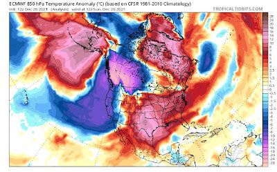
Temperature extremes this week in North America
have led to some bizarre weather in Alaska
As you can see in this map, there's record warmth
in Alaska the central United States and northeastern
Canada with record cold in southwestern Canada
and parts of the northwestern United States.
 Alaska is a land of weather extremes.  In the middle of the state, it can be 60 below in February and 90 in February.  Massive storms rake the coasts. The mountains down by Juneau can collect unbelievable amounts of rain and snow. 

But what's been going on lately is ridiculously off the rails.  I mentioned a hint of it yesterday, when I discovered a report of a temperature of 8 degrees in Tanana with freezing rain falling. 

It got even more bizarre in this vast northern state Monday.  Kodiak, Alaska, on an island in the western Gulf of Alaska southwest of the mainland, reached 65 degrees on Monday. 

It was easily the hottest temperature ever recorded in Alaska in December. Moreover, according to the National Weather Service office in Anchorage, it was the hottest temperature on record in Alaska for any date between October 5 and April 21.  Which means it was the hottest on record for not only December, but November, January, February and March as well. 

Kodiak's high temperature broke the record high for the date by 20 degrees. Which is a lot. It's equivalent to temperatures in the upper 70s in Burlington this time of year. Which is impossible. I hope. Most record highs this time of year in Vermont are in the upper 50s.

Meanwhile, deep in the interior of Alaska, Fairbanks is normally a very cold, dry place this time of year. Temperatures this time of year are often all over the place, but it's mostly very dry, with just little bits of snow here and there falling down during the winter. 

Not this year.  On Sunday, Fairbanks was slammed with tons of freezing rain and snow. If you melted down all that ice and snow, you got 1.93 inches of water, which was easily the wettest December day on record up there, and the third wettest for any time of the year. Precipitation for the month up there is 4.75 inches, the most on record for December. Normal precipitation for the month is around a half inch. 

Temperatures were in record territory in Fairbanks, too, with highs around 40 degrees the past few days.  The warmth in Alaska is coming after an especially frigid November and December, even by that state's standards. 

Alaska's extremes are coming as incredible temperature anomalies are occurring across almost all of North America. Record warmth is happening in Alaska, a vast stretch of central and eastern United States and in northeastern Canada. Record lows and brutal winter storms are hitting southwestern Canada and the northwestern United States.

(Vermont is one or the few places in North America where temperatures are fairly close to normal).

The extreme warmth does cover an area much larger than the extreme cold, even if that patch of cold in southwest Canada is record setting.  I'm pretty sure this bizarre weather week is brought to us in part by climate change.

The temperature extremes are contributing to a near record fast west to east jet stream over the United States. Flights from Los Angeles bound for New York are landing way earlier on the East Coast than scheduled as a result. 

Monday, December 27, 2021

National Weather Off The Rails Again; Record Heat, Big PAC NW Winter Storms, Fires And More.

Photo looks a bit like April in Vermont, but it was a 
springlike Frederick, Maryland on Sunday, where
temperatures were in the upper 50s under bright
blue skies. Maryland was on the edge of 
some record heat engulfing the southern U.S 
 In the grand scheme of things, the weather in Vermont this week is kind of boring.  The Christmas Day ice notwithstanding, the rest of this week will feature temperatures not incredibly far from normal, and any oncoming bits of snow or rain or mix  don't look too far off into bizarro world.  

Vermont's "boring" weather this week is a big exception to a national rule. I'm writing this from my temporary perch, for today in Frederick, Maryland.

Yesterday, Boxing Day was a gorgeous spring day here in Maryland.. Plenty of sunshine, temperatures well up into the 50s, the day after it was in the 60s. In Frederick, I saw a bush on one street here with lovely new pink blossoms, buzzing with bees.

Normally this time of year, it's barely 40 degrees during the day.

Frederick, Maryland was not even close to the most extreme weather the nation has been seeing the past few days. 

Hot, frigid, stormy, fiery, windy, snowy, icy, you name it. It's there. We have some huge contrasts going on in the nation as we close out the year 2021.

Let's start with heat, since it covers such a big chunk of the nation. 

On Christmas Eve, Wichita Falls, in northern Texas reached 91 degrees, that city's hottest December reading on record. 

Video from Live Storm Media showed strong winds causing minor structural damage and filling the air with thick dust around Amarillo, Texas. Winds there gusted to at least 56 mph on Christmas Eve.

Record highs continued in Texas on Christmas Day and yesterday. This heat was punctuated by a new round of odd winter wildfires that extended on up into eastern Colorado.  Most of Colorado should be a chilly snowscape this time of year.  At least Colorado's mountains and ski areas managed to get some snow Sunday. 

On Christmas Day, record high temperatures were spread far and wide. Records included 86 degrees in Abilene, Texas, 67 in Cincinnati, 74 in Paducah, Kentucky, and 72 in Evansville, Indiana.

In Rio Grande Village, Texas on Christmas Day, it was reportedly 96 degrees. If that reading is verified, it will be the record for the hottest Christmas Day on record anywhere in the Lower 48. 

Down in Houston, it's been in the 80s thirteen times so far this month, and each of the closing days of this month should also reach 80 degrees there. This will easily be that city's hottest December on record. Normal highs in Houston this time of year are in the low to mid 60s.

It's not just Houston. After four record December heat waves in the Midwest and South, many cities in the United States look assured of having their warmest December on record.

This is in huge contrast to the Pacific Northwest and British Columbia, which are in the grips of a pretty intense - at least for them - spell of winter weather.

In a rare moment for the region. the field had to be cleared for a Seattle Seahawks Sunday to prepare for a game with the Chicago Bears. At least the Bears should have been ready for winter conditions. They did manage to squeak out a 25-24 win over the Seahawks. 

In California, snowfall in recent days measured in feet, not inches.  Many roads through the Sierra Nevada range, including Interstate 80, had to close due to the deep snow.  Donner Pass has had 119 inches of snow so far this month. The record for December there is 179 inches.  It's supposed to keep snowing there for the next couple of days, so that record could be challenged.

The Sierra snow is mostly good news, though, because until mid-month, snow cover was well below normal there. Now, it's a little above normal, which could help dent California's drought. 

Those winter storms and cold are extending as far east as Lake Superior in the northern tier of states. Blizzard warnings are up for North Dakota today.  Though temperatures are well below normal from Washington to Minnesota, there aren't that many record low temperature records being set. Not nearly as many as the heat records further south and east, anyway.

Some of this cold air in the Northwest will be on the move to the east, which could easily cause another round of dangerous weather in the South. 

The unseasonable, record heat in the South, combined with rising humidity, risks causing another outbreak of severe storms and tornadoes in the upcoming week. The cold air approaching might well be the spark that sets off those storms on Wednesday.  Another round of severe storms seems possible New Years Day before the cold air finally takes over. 

This in a December that has already broken the record for the most tornadoes for the month.

The weirdness extends up into Alaska.  At one point Sunday Tanana, in normally frigid central Alaska reported freezing rain with a temperature of 8 degrees. I don't think I've ever seen rain fall at such a low temperature.

For us Vermonters, the Green Mountain State seems to be escaping most if not all of the nation's weather drama.  Several small disturbances will zip on by this week. 

As the warm weather pattern in the South and Southeast breaks down this weekend and early next week, that might spin up a fairly substantial storm that could give Vermont a pretty good dose of snow rain or schmutz by Sunday and Monday.  

Thursday, December 16, 2021

Epic Storm Departs Plains, Widespread Damage Left Behind

Satellite view of epic storm in the Plains late yesterday
afternoon. That white area on the right is a string of severe
thunderstorms and tornados. Where it curves back to the '
left is blinding snow squalls. All of that brownish color
in the middle and bottom are massive dust storms. 
 Early risers in Chicago awoke to the smell of smoke before dawn today. 

Nope, they weren't facing a new Great Chicago fire. Residents there were sensing the sad aroma of Kansas burning.  This was just one indication of how extreme and weird this storm was. 

The storm did pretty much what it was expected to do, meaning it set records for temperatures, wind speeds both inside and outside thunderstorms, tornadoes and more.'  And was completely off the rails. 

The smoke people in Chicago, and other cities like Omaha and Des Moines smelled was from incredibly fast moving wildfires in Kansas and Oklahoma.  All those cities also reported dust blown from Colorado and Kansas hundreds of miles into their communities.

The fires threatened towns and hamlets in both states. Parts of Guymon, Oklahoma were evacuated, as winds gusting to 79 mph pushed the flames. One house was destroyed by fire.  In Russell and Ellsworth counties, Kansas, two fires merged to produce a fire front that was at one point 40 miles long.  

NOAA' s Storm Prediction Center has 21 preliminary reports of tornadoes as of this morning. One of them was near Rochester, Minnesota, making that the first recorded December tornado in that state.

Winds gusts reaching 85 mph or more extended from Colorado to southern Minnesota, helping illustrate the huge area covered by the intense winds.  The Washington Post said Wednesday brought the most number of reports of winds of 75 mph or higher in a single day since 2004. 

Numerous homes lost roofs in Nebraska, Kansas and Colorado. A building collapsed in Kansas.  The wind was strong enough to blow windows out of cars parked in Hampton, Nebraska. The control tower at Kansas City International Airport was evacuated for a time because winds were too strong for personnel to be safe there.

The police headquarters in Colorado Springs was among the buildings that lost roofs.

Dust storms reminiscent of the Dust Bowl days of the 1930s ripped through the Plains, too, closing Interstate highways, causing crashes and widespread air quality alerts.

The warmth ahead of the storm also broke some impressive records.  In Des Moines, it got to 74 degrees, breaking the record for the warmest December day on record by five degrees.  Madison, Wisconsin also had its hottest December day on record, reaching 68 degrees. Columbia Missouri, 76 degrees, Quincy, Illinois, 75 degrees and LaCrosse, Wisconsin, 69, degrees all also set new December records. 

That weird, extreme storm is now heading into Canada, creating 34 foot waves on Lake Superior as a parting shot. 

The weather is now settling down into something a little more normal.  But there's still some trouble on the horizon.  Western Kentucky, still trying to somehow recover from last week's horrific tornadoes, now faces a forecast of heavy rain and possible flooding tomorrow.

Here in Vermont, the outer edges of that immense Midwestern storm is still set to create some record high temperatures today.  Gusty winds today and tonight might cause a few power outages here and there. A new storm is also now expected to give us a mid-sized snowstorm Saturday and Saturday night. More on that tomorrow. 

Videos. If you're using a mobile device, click on the hyperlinks to view. 

Fox Weather has some video clips of storm scenes. I'm impressed by the amount of lightning last night in Iowa: 


The Washington Post also had some clips of the storms: 


Tumbleweeds pile up in the strong winds in this Colorado neighborhood: