Wednesday, August 31, 2022

Some Of Those Vermont Storms Tuesday Hit Hard; Two More Cold Fronts Introducing Cool Blast

This map from the National Weather Service in South
Burlington shows the best rains from last nights
cold front went through eastern New York, northwest Vermont
and the Connecticut Valley.
 Tuesday was the last day of hot, humid weather we'll see in awhile. In fact, there's a reasonable chance it will be the hottest day until next summer. 

The heat broke in dramatic fashion in some areas with a fast moving cluster of severe storms that raced mostly northward through western and central Vermont. 

Some of the warnings ahead of the storms were more dire than usual, with the alerts warning of 70 mph gusts and ping pong ball sized hail.

The scattered nature of storm reports suggests the storms didn't get quite that bad, but some of them were certainly in the severe category.  

Reports of tree damage came in from Burlington's New North End, Malletts Bay in Colchester, St. Albans Bay, Georgia, and West Milton.

It seems the intense winds with the storms weren't fully able to mix down to the surface, except near the shores of Lake Champlain. 

I didn't manage to chase myself into any of the severe storms, but you can see snippets of what I did find in the video at the bottom of this post. Some people caught in the downpour, a free spirit enjoying it, some Interstate 89 drama and tree damage. 

The initial round of storms moved so fast that they didn't deposit much rain. But a slow moving batch of rain following the storms by several hours last night made up for it in a few spots, anyway. 

It looks like there were two decent swaths of rain. One, depositing an inch or more. extended from the Adirondacks through northeastern New York and northwestern Vermont. Another went from Rutland and Windsor counties, then up the Connecticut River Valley all the way to Quebec.

A flood warning was issued for an area around Tyson, Bridgewater and Plymouth as they had up to three inches of rain in less than three hours, but the flooding turned out to be minor. 

NEXT UP:

It was still vaguely humid out there early this  morning, though better than it was yesterday.  A second cold front coming through between mid morning and noon will produce a smattering of light showers, but not change the air much more. It might lower dew points a bit for the afternoon.  

Tree damage from Tuesday's storms in Georgia, Vermont. 


Some sunshine breaking out ahead of a third cold front could create a few more showers and storms toward late afternoon or evening.  A few storms might be strong-ish in northern New York, but I don't anticipate anything that wild. In fact, most people will probably avoid any storms.

Nobody will avoid what comes after this front, though. The air behind it is much cooler and much more humid. 

Tomorrow is the start of meteorological fall. For organized record keeping, climatologists and others regard autumn as the period from September 1 to November 30.

Nature will match up with the start of meteorological autumn, as tomorrow will be the coldest day since the third weekend in June. Most of us won't get out out of the 60s for highs tomorrow,  under partly cloudy skies. Also, most of us will get down into the 40s tomorrow night, with the cold hollows reaching the upper 30s. 

It'll quickly warm back up Friday and Saturday, but this is a reminder that summer is just about over. Given forecast trends, we might have a few more very warm and humid days during September, but not many.  It's just about time to stick a fork in summer. 

Here's the video of yesterday's storms. Click on this link if you don't see the image below, otherwise, click on that image to view. 


Tuesday, August 30, 2022

Hot Times To Come To An End With Drenching Storms

 Last night was really as oppressive as you can get in Vermont, especially in the Champlain Valley.

This is the National Weather Service in South Burlington's 
idea of where the heaviest rain will fall later today and
tonight. More than an inch is in the forecast west of the
Green Mountains. Note that actual rain totals will
differ from what's shown here. It all depends on where
the heaviest showers and storms set up.

It never got below the mid-70s in Burlington.  The record for the "highest" low temperature for the date is 71 degrees, set in 1973. 

 I don't think we'll set a new record today, though, as I expect showers and storms will cool Burlington off below that 71 degree mark by midnight tonight. 

But I'm getting ahead of myself just a bit here. 

First, we have to survive another day of warm, and very humid weather. Dew points will be within a few degrees either side of 70 degrees, so it will be another sweaty day. Before showers and thunderstorms arrive, actual temperatures will probably soar well into the 80s again. 

That sets the stage for a rather stormy late afternoon and night in Vermont.  We're still watching that juicy, slow moving cold front approach us. That front created storms that actually prompted a tornado warning north of Watertown, New York last evening, but those storms quickly diminished to sprinkles by the time they reached Vermont. 

It'll be a different story today.  No tornadoes, but a few storms could get pretty rambunctious and some will have drenching downpours, sort of like what hit Burlington, Vermont last Friday. 

Most of us won't have severe storms, but a few isolated ones this afternoon and evening could create what are know as wet microbursts. 

The term "wet microburst" sounds like a harmless, tiny water balloon popping, but these microbursts can be dangerous. 

A bit of dry air can get entrained into a thunderstorm, which causes a little evaporation and cooling. That causes air to sink. Meanwhile, the thunderstorm is absolutely loaded with rain drops. Those drops are heavy. So everything ends up falling at once. A big packet of wind and rain drops vertically to the ground, then spreads out when it hits the ground.

Wind speeds in microbursts can easily exceed 60 mph and the torrents of rain can cause a local flash flood. These things can cause a lot of damage in a small area.

Luckily, there won't be too many of these with this cold front in Vermont later today. 

Still, many of us will experience lightning, gusty winds and especially some heavy downpours. After sunset, there won't be any severe thunderstorms, but the threat of torrential downpours continues. We'll have the usual threat of local street flooding and minor washouts, but nothing horrific. 

For most of us, this is a good thing. We need the rain. Especially since after this episode, we've got a long spell of dry weather coming up. 

The best rainfall will probably be west of the Green Mountains, which is actually too bad, since southeastern Vermont needs the rain the most.  Rainfall will be incredibly variable with winners and losers. But generally west of the Greens, most places can at least hope for an inch or more of rain. Parched southeastern Vermont, which is officially in drought conditions,  could get as little as a quarter inch. 

Rain will be pretty much over by tomorrow morning, except maybe in the Northeast Kingdom. It will be somewhat cooler, and definitely less humid on Wednesday as well.

A second cold front arrives Wednesday afternoon with a few scattered showers and garden variety thunderstorms. After that goes by, you'll really notice the change. It will be decidedly cooler. 

Thursday will probably be the coldest day since mid June or so. That's a relative term, of course. We can expect highs on Thursday to be in the 65 to 70 degree range.  That's cooler than normal for this time of year, but nowhere near as chilly as it can get in the opening days of September. 

Likewise, temperatures early Friday morning will be in the 40s for most of us. Again, cool, but nothing unusual. 

Temperatures will pop back up to a little above normal by Saturday, but nothing like we saw the past few days. Another cold front will bring us back down to the pleasant low 70s by Sunday and Monday. 

It'll probably be warmer than average most of the time, though through mid-September. But this being the end of summer, we'll see some cool shots of air mixed in there as well. The heat of summer is almost over. 

Monday, August 29, 2022

Yet Another Never Ending Summer? Will Stay Warm In Vermont For Awhile Yet

Weather dogs Jackson and Tonks grab a bit of cool
evening air Sunday after another very warm August
day in St. Albans, Vermont.  August, 2022 will
be among the top ten warmest on record. 
 It used to cool off noticeably in Vermont in late August and early September. 

We'd even get Labor Day Weekend frosts occasionally in the coldest hollows.  Not in recent years, though.  Summers in recent years have extended well into September. It looks like we might do the same this year. 

It's pretty wild to see just how backloaded summers have become in Vermont.  August and large chunks of September have been breaking heat record in recent years. 

In Burlington, the top 3 hottest Augusts were in 2018, 2021 and 2016. Six of the top ten warmest Augusts have been since 2001.  And this August will almost surely score in the top ten warmest as well.

September is even more remarkable. The only September since 2015 that is not in the top five warmest was in 2020.

The warmest list:

1. 67.4, 2015

2. 65.8, 2018

3. 65.7, 2017

4. 65.7, 2016. Yes, that's a tie with 2017, actually.

5. 64.6, 2021

We don't know how this September will pan out, but as noted, we know August, 2022 will be in the top 10 list.

All this is most likely just another way climate change is altering how we experience Vermont seasons. 

August will end on a (mostly) toasty note this year, and the opening of September looks at least a little on the warm side, too. Maybe quite warm on some days. 

After a weekend of sunshine and comfortable humidity, the oppressive air returns today, with afternoon temperatures well up into the 80s. A couple warm spots could touch 90 degrees. The humidity will rise as well. 

It won't be record heat, but it will be hot enough so that you'll need to take it easy, drink plenty of fluids, and keep your pets in cool places with plenty of available water. 

We'll "enjoy" another stuffy night tonight.  Tomorrow, a slow moving cold front will approach from the west.  According to the National Weather Service, increasing clouds and showers will cool northern New York enough so that highs stay near 80 at best.

In Vermont, it'll be another muggy, hot day, with temperatures well into the 80s once again. 

The front could produce some heavy rain as it grudgingly passes through Tuesday night and Wednesday. A second cold front will probably touch off a few more showers Wednesday afternoon. We'd better hope we get a real soaker out of this one.  A very long dry spell will follow, in addition to the generally warm temperatures. 

We do manage to get a shot of semi-autumnal air Thursday and Friday.  High temperatures Thursday might not get past 70 degrees, and many places will dip into the 40s Thursday night. 

But it will warm up by the weekend, with  highs once again near 80 degrees. It gets  harder to see mid-summer heat in September. But it seems a lot easier lately to keep at least some of the heat on into the start of the school year. 

Extended forecasts keep Vermont mostly warmer and drier than normal into mid-September at least.  


Sunday, August 28, 2022

A Sunny Anniversary Garden Party And A Not So Stormy Marriage

Jeff Modereger and I tying the knot a 
decade ago, August 26, 2012. It's been
sunshine and blue skies since. 
 This post is only tangentially related to the weather, but that's OK, we'll manage for one day, right?

Here in St. Albans, Vermont, we're having a garden party to celebrate our tenth wedding anniversary. Hard to believe Jeff and I have been married ten years, but there you go. 

Our wedding anniversary was actually this past Friday, but we decided the celebration would be today. The weather gods blessed us with a cool morning to get ready for the shindig, and the day promises to be very sunny and comfortably warm. 

On the day we married, August 26, 2012, the weather was very much like what is forecast today. It was sunny and in the 80s. 

I guess our entire marriage has been like that, from my perspective. Sunny and warm. Oh, sure, we've had our chilly. even frosty moments, like everybody does, but those quickly pass. The gusty storms of arguments pass by even faster. These storms were never severe, and didn't seem to leave behind any damage. 

It's one of the reasons I married Jeff in the first place. He has a sunny, optimistic disposition as opposed to the occasion dense fogs of pessimism I try to fight back. 

The winds of time blow strong, and things are of course different now than they were. Our young puppy Jackson of 2012 is now an old dog, not learning many new tricks. Jeff and I have aged, and I've started referring to ourselves as Statler and Waldorf.

Our surroundings are different. Jeff redesigned our decrepit house into a showcase. I took an overgrown sad property and turned it into gardens. 

I think of our marriage as a kind of force field. Knock on wood, we hope it continues. We've been lucky. Disasters have mostly not befallen us. We're like that house on the end of the street that looks fine after the tornado while all the other homes in the neighborhood are leveled.

I'm a challenging person to live with. Some scars from my sometimes problematic childhood sometimes get in the way. And my ADHD is frustrating to me, and more so to the people around me. How Jeff puts up with this, I'll never know. 

He's a strong guy, and I get nourishment from that. He's the long rainy spell to my droughts of doubt. The warm south wind that melts away my icicles of frustration. The sunshine that cuts through the low clouds and drizzle, dispersing all that to create a blue sky life for me. 

We look forward to the future, even though we don't know what that will bring. Long range weather forecasts are seldom reliable, and guessing what things will be like in five to ten years is just as iffy. 

They say that climate is your personality and a day's weather is your mood. The Climate of Jeff is steady,  stable, comfortable, not prone to extremes and makes life feel safe. The opposite of the climate crisis afflicting the real world, I guess. 

So I have that. It's a lot. I got extremely lucky when I met Jeff. He'd better know that. I was actually reluctant to marry him at first. Not because I had any misgivings about Jeff. I didn't. I had misgivings about me. 

It always seems to rain on my parties. So I figured a marriage would just end in a stormy disaster, just like so much of life does.

I thankfully found the courage to run my life without worrying about the "weather" so much. Jeff gently encouraged that. I made by far my life's best decision when I popped the question. That yes I got meant the world to me, and still does. Even more so than it did a decade ago. 

It turned out the marriage did not lead to more storms, more gloom in life. Over the past decade, Jeff has slowly made progress in making me understand that life is partly sunny, not partly cloudy. 

When I was little, I was terrified of thunderstorms. Now, I love them. They're my favorite kind of weather.   Jeff is teaching me to understand that all of life's "thunderstorms" are not something to hide from or fear. but you learn from them. Problems might be a pain, but they're interesting.  I'll never love life's challenges, and I'll always whine about them but Jeff is making me realize when you face storms together, you win.  

 Thanks to Jeff, it's been wall to wall sunshine through a decade of marriage.  Just like the weather will be today during our celebratory outdoor garden party. 

I think today's weather forecast is a good omen for Jeff and me. I love you so much, Chief! 

Saturday, August 27, 2022

Friday Thunderstorms Caused Only Scattered Issues; Gorgeous Weekend Ensues

Lightning crackles over Burlington, Vermont
Friday afternoon in this screen grab of
a video I shot during the storm. 
The severe storm setup from Friday played out pretty much as expected.

Severe weather was limited to southern Vermont, and mostly Massachusetts and New Hampshire, save for one rogue storm in and around Burlington, Vermont. 

 That one storm well north of the "danger zone" did cause a stir. As it moved over the Burlington area, the National Weather Service saw fit to declare a severe thunderstorm warning. The storm did knock down at least one large tree in Essex, and did away with a few other trees and branches.  The wind was clocked at 41 mph at the airport, and some gusts surely reached at least 50 mph. 

.I was in Burlington's North End during the storm, and I'd say more than an inch of rain fell in less than an hour. As you can see in the video at the bottom of this post, some street flooding resulted. 

All in all it was a borderline severe storm, and pretty fun to watch. Video of this storm is at the bottom of this post.

Further south, severe thunderstorm warnings popped up midday along and south of Route 4.  I haven't seen much in the way of damage reports in southern Vermont, but those storms did topple trees and pelt parts of New Hampshire and western Massachusetts with quarter sized hail. 

Now that Friday's excitement is over, we can look forward to a gorgeous weekend. 

It might look a bit murky in some parts of Vermont this morning with low clouds, areas of fog and maybe a patch of drizzle or two.  All that will get flushed out by northwest breezes, leaving us with a mostly sunny afternoon.

Flooding along Riverside Avenue in Burlington, Vermont
Friday afternoon after an intense thunderstorm downpour.
After the recent muggy weather, the air will feel fresh and dry, and probably give you a little energy you were lacking when the air was so oppressive. 

It'll be a delightfully cool night for sleeping.  Some of you might wake up to murk again early Sunday morning as dense fog will collect in some valleys. 

That'll quickly burn off to leave us with a sunny, warm, but not particularly humid day. Great for anything outdoors. (I'm having a garden party at my house in St. Albans, Vermont Sunday, so I'm really lucking out here). 

In almost a last hurrah for summer, another blast of very warm, humid air is due to strike Monday and Tuesday. We might have to deal with more strong storms and/or heavy rain on Tuesday. We'll have to see about that. 

It's getting into September, so cooler weather will surely follow that humid spell. 

Video.  Scenes from a powerful thunderstorm in Burlington, Vermont Friday. If you don't see the image to view it below, click on this link to watch it. I liked how the storm gradually built up and intensified in the video. 


Friday, August 26, 2022

Today's Iffy Vermont Severe Weather Forecast

Forecasts for severe weather haven't changed much from
yesterday. Slight chance of severe storms in yellow,
just a marginal, slight chance in dark green. 
UPDATE 1 PM FRIDAY

Things so far seem to be playing out as expected, with the worst of the scattered storms today appearing to target central and southern Vermont, along with much of central and southwestern New England, with parts of New Hampshire and Maine getting in on the act.

NOAA's Storm Prediction Center said they'd likely issue a severe thunderstorm watch for an area encompassing most of southern New England, the southeastern half of Vermont and large swaths of New Hampshire and Maine. 

Giving hints to what might be to come, a fairly strong line of storms went through southern and central Vermont late this morning and early this afternoon.

One storm has prompted a severe thunderstorm warning around White River Junction. The National Weather Service said the storm could generate strong, damaging winds.

Radar imagery indicated that storm was rotating, but so far not enough to produce any kind of spin up tornado. 

Another severe thunderstorm warning for winds of up to 60 mph just went up for Bennington County as of this writing, 12:50 p.m. 

Other lines and clusters of storms should form this afternoon and move west to east across Vermont. The air, as expected, is more stable in northern Vermont, so if any severe storms develop there, they'd be very few and far between. 

Up north, you might get lightning and some downpours, but I'm not overly bullish on much north of a Middlebury to Wells River line. However, I did notice at 12:55 a rapidly developing line of storms over northeastern New York, probably heading toward Franklin County, Vermont. 

PREVIOUS DISCUSSION

There might or might not be severe storms in Vermont today. 

Chances are at least a few towns will get slammed by strong, possibly damaging winds, but the question is, how widespread will this be?  

Working in favor of storms are some fairly strong winds aloft, which also change direction with height. 

We expect a fairly good contrast between warm temperatures near the surface and much cooler readings aloft. That helps thunderstorms develop. 

The timing of an approaching cold front is pretty good, too. It'll come through this evening, giving a chance for strong storms to form ahead of the front.  

Clouds and rain this morning could, maybe, stymie some of the storms this afternoon.  A warm front was lifting through Vermont early this morning, accompanied by lots of showers and maybe some rumbles of thunder. 

If these showers don't move out fast enough, or leave lots of debris clouds behind overhead, that would limit, but not stop the severe weather threat. But if some sun can come out in the increasingly humid air today, that would boost the chances of strong to severe storms. 

With all that said, the forecast hasn't changed much from yesterday. The best chance of seeing some severe storms this afternoon are south of Route 2. The biggest threat would be from damaging wind gusts. Most of Vermont is still under slight risk of severe storms, level two of five in the threat scale. 

We still have a very, very, very low, but not zero chance of a brief spin up tornado. That's if any supercells can form out ahead of any lines of storms that develop. 

In the end, we'll probably wind up with a handful of reports of wind damage in a few towns in Vermont. Of course, it's impossible to tell in advance which towns. I don't think there will be any real trouble with local flash floods. The rain will come down torrentially with some of these storms. But, they will be moving right along, so it probably won't rain enough in any one spot to trigger trouble. 

You'll just have to pay attention to the skies and any warnings the National Weather Service might issue. Be ready to duck into a sturdy building at any time this afternoon and evening if you see dark clouds approach, hear thunder or receive a warning or special weather statement. 

It's not a good day to go out on the lake or take a hike. You can do that during this weekend, when the weather is going to be absolutely gorgeous. Instead, stay close to places where you can shelter from a storm. 

Saturday will actually be a bit on the cool side. It is almost September after all. Most of us will stay in the low to mid 70s under sunny skies.  The sun will continue all day Sunday, but you'll notice it warming up again. 

After a brief spell of very warm and humid weather (Again!) early in the week, it looks like it will turn cool again. We're almost ready to put a fork in summer. 

Thursday, August 25, 2022

Head's Up! Friday's Vermont Weather Could Get "Interesting"

National Weather Service has a chance of 
severe storms over New England, including
here in Vermont during the day Friday. 
 Although today will be unremarkable in the weather department here in Vermont, Friday could get a lot more interesting. At least in a few spots. 

The ingredients seem to be coming together for the risk of severe storms and pockets of torrential rains.  A this point, central and southern Vermont seem to be the main target, though that could change.  

For now, NOAA's Storm Prediction Center has central and southern Vermont in a slight risk zone for severe weather. That's level two of five in its alert scale. Far northern Vermont is a marginal risk zone, level 1 of 5, which means only isolated, brief severe weather might happen there. 

As is always the case, most of us won't see damaging weather, but there could easily be a few pockets of strong winds, heavy rain and hail.  You know the drill. There's even another very, very low, but not zero chance of a brief tornado. If that happens, it will probably be south of Route 2. This risk might  happen if any supercells form ahead of any lines of storms. 

A very weak front from Canada today is pressing south into Vermont. That will give us a tiny, tiny bit of relief from the humidity, and possibly set off a widely scattered shower. 

However, the humidity will flood back in overnight and on Friday. That high humidity will greet a stronger cold front sagging south from Canada. 

Early indications are that the front might arrive in far northern areas with its clouds early enough in the day to prevent a lot of instability from forming. If this happens, northern areas would mostly lose the chance for severe weather. Of course, the front could always slow down, leaving the north with some morning sunshine.

Further south, the chances of morning sun are better. That will increase instability. This will probable evolve into clusters of storms, and possibly bowing lines of storms. 

A bowing line is shaped like a backwards "C." The part of the line that is at the apex of this backwards C would have damaging winds. 

Another risk is torrential downpours, especially if several storms go over the same spot. All of New England and northeastern New York is in a marginal risk zone for excessive rain and flash flooding.  That means there won't be anything widespread, but there could be a pocket of flash flooding in one or two spots. 

If any flood issues develop, it would most likely be in a spot that got a ton of rain Tuesday, and then gets lucky or unlucky enough to get hit by a couple or few storms tomorrow. 

Things clear out Friday night to leave us with a nice weekend. Saturday in particular will feel nice, with lower humidity and noticeably cooler temperatures. That means highs in the 70s. Sunday will start off coolish, but you'll notice a bit of warmth and humidity creep in during the afternoon as high temperatures top 80 degrees.

The forecast for tomorrow's storm risk will certainly evolve and change, so of course I'll have an update tomorrow morning.


Wednesday, August 24, 2022

Hit And Miss Vermont Downpours Depart, Humidity Unfortunately Lingers On And On

Kind of a chaotic looking sky over South Burlington,
Vermont Tuesday amid scattered torrential downpours.
Those torrential downpours that hit just a few spots in Vermont yesterday are mostly gone, but unfortunately, the humidity is not.  

This is turning into one of those Augusts in which summer doesn't want to end. There seemed to be a turning point mid-month when we seemed to want to go into the normal late August cooling. You know, fair week weather. Warmish but not hot afternoons, cool nights. 

Well, that's been interrupted for now, hasn't it? This was the fourth morning in a row in which the overnight low in Burlington was close to 70 degrees. Dew points, a measure of how humid it is, remain stubbornly in the mid to upper 60s.

That humidity is why we had those gully washers on Tuesday. It wasn't full on drought relief, because a lot of places missed out. 

An impressively dark cloud I saw north of Burlington early Tuesday afternoon seems to have unleashed on Westford, which reported 3.08 inches. Other hot spots for rain include Brunswick, in the Northeast Kingdom, with 3..01 inches of rain. A spot near New Haven reported just over two inches.

There surely was some minor damage from the worst of these storms, but I have no reports of anything serious.

Springfield reported 1.67 inches and Rutland clocked in with just under an inch. Here at my hacienda in St. Albans, I received a respectable 0.6 inches.

Other places got cheated and remain dry, despite the humidity. Burlington had a ho-hum 0.22 inches. Montpelier only managed 0.03 inches.  

Elsewhere in New England, a small section of southeastern Massachusetts and Rhode Island, under severe drought, received up to seven inches of rain in a few hours, causing flash flooding. That continues a trend we've seen in much of the nation with droughts and floods combining. 

In this soupy air, watch out for patchy dense fog this morning. There could be a few scattered showers and storms today, but they will be few and far between. The best chances will be in the Northeast Kingdom.

The next chance of any rain is late Thursday night and Friday.  A cold front will be interacting with the humid air to launch more showers and storms. It's too soon to know for sure, but if we end up with any slow moving or "training" storms, we could be dealing again with.

The cold front will bring brief relief from the humidity Friday night and Saturday. But it will start to warm up again Sunday, though on that day the humidity will still be manageable under sunny skies. But it will probably be oppressive again by Monday and Tuesday.

There is some hope - not a certainty - that we will finally get a push of refreshing, slightly autumnal air during the middle of next week.  

Tuesday, August 23, 2022

Interesting Weather Afternoon In Vermont; Drought Relief For Many, But Too Much For A Few?

Heavy showers developing south of Burlington 
late this morning
 Weather radar has been lit up since mid-morning in Vermont and eastern New York with many showers, some heavy, and a few embedded thunderstorms. 

The worst of them could even cause local floods. 

As of 2:30 p.m this afternoon, we still had lots of showers and storms around. For most of us, this is a good thing. It's too dry, and we need the rain. I noticed a few trees have yellow leaves and are dropping some of them as a defense against the dry weather. A stormy afternoon is just the ticket for Vermont. 

Most of the storms weren't covering a big area, but a few were strong.  We don't expect severe weather today, but locally torrential rain could become an issue. 

That's especially true if any one location gets hit repeatedly by a train of torrential storms.

As of early this afternoon, we had a local flood warning in the area where New York, Vermont and Quebec meet. This includes Isle La Motte and Alburgh, Vermont.

As of 1:20 p.m. in that area, up to 2.5 inches of rain had fallen and up to 1.5 more inches was expected. Some roadways were already covered by water. All this happened because torrential showers "trained" over the area, so it kept repeatedly pouring. 

At 2:30, that train of storms near Alburgh appeared to be weakening, but more storms were downstream and could hit that region. 

A flood advisory was also in effect around Manchester, Vermont due to locally heavy rain there at mid-afternoon. 

I noticed that a smaller and more brief train of storms early this afternoon caused a bit of minor erosion damage in parts of northern Chittenden and Franklin counties.  Thankfully, it wasn't nearly enough to trigger any flood alerts.

NOAA's Weather Prediction Center decided late this morning to put Vermont and adjacent areas under a marginal risk of flash flooding, meaning we had a risk of isolated pockets of flooding. Had it been wet prior to today's weather, the risk of flash flooding would have been higher. 

Thunderstorm clouds billow high into the sky over the 
Adirondacks west of Burlington, Vermont late this 
morning This storm was one of several that ventured
toward the extreme northwest corner of Vermont,
prompting a flood warning

The showers and storms are all moving slowly, so they could linger over some areas, adding extra rain. It's pretty damn humid out there, so there's no question the rain could be torrential. 

It probably won't flood where you are. But there's a low chance it could. Remember, water rises super fast in these torrential storms. I know the "Turn Around Don't Drown" admonishment can feel kind of obnoxious, but it's a good rule of thumb if you: A. Want to live and B: Are not ready to buy a new car. 

If you see water across a road way ahead of you, don't chance it. Doing a detour is annoying, but getting caught in a flash flood and needing a rescue and wrecking your car is so much more than annoying. 

Total rainfall by tonight will be extremely variable. The unlucky among us Vermonters who really need the rain could see a tenth of an inch or less. The few pockets of flood zones could see in excess of three inches. Most of us will settle on a half inch of rain, give or take. 

Today's Vermont weather is a minor example of how droughts are being periodically interrupted by torrential rains and flooding. I definitely can't say whether today's conditions have anything to do with climate change. But it is consistent with the phenomenon.


This all should taper off this evening and tonight, ending the threat of any dangerous weather. 

Latest Victim Is Dallas: Epic Rains This Summer As Impressive As The Heat Waves

From extreme drought to extreme flood. Here, a 
wildfire consumes houses in Balch Springs, Texas,
a Dallas suburb, one month ago......
The incredible rain storms just keep coming this summer, almost matching the constant onslaught of heat waves affecting different parts of the world. 

Every day it seems, there's news of a fresh, intense flash flood. Virginia, Kentucky, Illinois, Phoenix, Tucson, Flagstaff, Sioux Falls, even Las Vegas. Some of these floods are hitting places that were deep in drought when the storms hit. 

The latest victim is what was until this past weekend night bone dry Dallas, Texas. 

Four to eight inches of rain deluged the city overnight Sunday into Monday.  In just one hour, 3.01 inches of rain fell in at the officials weather station at Dallas-Fort Worth airport, its wettest hour dating back to at least 1953.  That amount of rain in one hour is more than in any other month so far this year.  

In all 9.19 inches of rain fell on the Dallas-Fort Worth airport, its second wettest day on record. A station in East Dallas reported 15.16 inches. The flooding was localized, but badly localized, concentrating on a heavily populated part of Texas. McKinney, just 25 miles north of Dallas, reported only a very manageable 0.86 inches of rain.  

At least one person was reported dead in the flooding. There were many other close calls. 

That same Dallas suburb of Balch Springs that was
on fire a month ago was inundated by Monday. 
Videos from Dallas show extreme flooding in neighborhoods. Other videos show water rescues, including one man who appeared to nearly drown before being pulled to safety by emergency responders.

Other social media posts showed a couple feet of water inside some homes and apartments. 

The flooding whiplashed the area from drought to flood. In the Dallas suburb of Balch Springs, a wildfire destroyed several homes one month ago. Parts of that same suburb was inundated Monday.

This is at least the third one in one thousand year flood in the United States this summer.  St. Louis and Kentucky had their own thousand year floods this summer

Summer is the season for flash floods in the United States, especially mid and late summer.  The jet stream is way north in Canada, so if you get a good thunderstorm complex, chances are it will move very slowly, dumping intense rains on one spot for a long time. 

The Gulf of Mexico and the Atlantic Ocean have had much of the summer to heat up, so now those huge bodies of water are finding it easy to send soupy, tropical air deep into the United States, just begging to trigger downpours. 

Also, the monsoon season in the Desert Southwest and southern Rocky Mountains is in full swing, increasing the chances of flash flooding. 

Interstate 30 in Dallas early Monday.
Plus, the peak of hurricane season is coming soon, in the second half of August and September. Those storms tend to produce serious inland flooding. 

This summer, however, has really been especially awful in the flash flood department. It's been in the news plenty, but aside from the human despair and deaths many of these floods have caused, the amount of rain has been way off the charts. 

These aren't your grandparents' extreme rainfall events. They're worse.  Climate change has taken what would have been pretty destructive, stressful events and supercharged them. Extreme rainfall is now, well, more extreme than it used to be. 

We live in a new era in which our infrastructure isn't built for this type of thing. More on that further below, but first:

Let's go through some of the highlights:

ST. LOUIS

The July 26  flash flood dumped nine inches of rain on the city's official measuring site in just one day, besting the St. Louis' previous 24 hour record by two inches. Some areas near St. Louis reported a foot of rain. The city also reported 7.68 inches of rain in just six hours, which is roughly double the amount of rain St. Louis normally receives in the entire month of July. 

Within just 12 hours, St Louis received a full 25 percent of its normal annual rainfall. 

To add insult to injury, another destructive flash flood struck St. Louis on August 3, dumping another four to five inches of rain 

KENTUCKY

The worst flood so far this summer was in eastern Kentucky, as previously mournfully noted in this blog thingy. 

One fairly narrow swath of mountainous terrain was blasted by about 15 inches of rain in four days,with most of that falling in a 24 hour period. A much larger area received six to 10 inches of rain. 

So much water fell that not only were these mountainous regions devastated. Larger communities downstream that did not receive much rain were also trashed. These communities are along main stem rivers which have some of their tributaries come from those mountains. These rivers reached record crests in places like Jackson, where the north fork of the Kentucky River reached a record crest.

This was the second one in 1,000 year flood the nation saw in less than a week. 

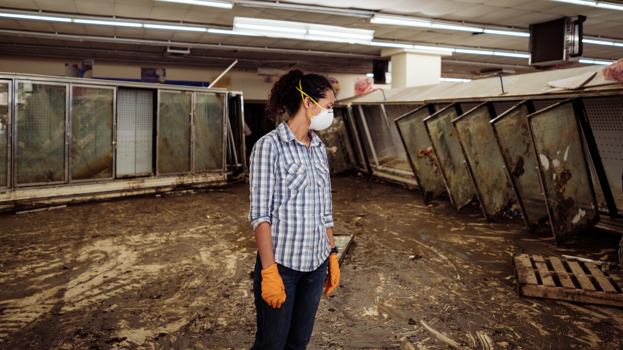
The owner of the popular Isom IGA grocery store in Kentucky
surveys the damage after the extreme flooding. The water
in the store had been six feet deep.

Note, this does not mean this kind of flood only comes once every thousand years. It means that every year, you have a one in one thousand chance of seeing an event like this. Big difference. 

The Kentucky flooding has also created one of the worst humanitarian crises the United States has seen in decades. The remote mountainous area of Kentucky had winding roads that were iffy at the best of times. They're now washed out, making it hard to reach people who need help.

The area has one of the highest rates of poverty in the nation. 

On top of that, new flash floods have kept cropping up in a wet weather pattern since the peak of this flood. These new floods have prevented a start on cleanup, and in some cases undid repairs. As I was working on this piece Sunday afternoon, new flood watches were in effect for eastern Kentucky, among other areas of Appalachia.   

Not all that far to the northwest, in central and southern Illinois, another intense round of rain dumped four to eight inches of rain on August 4-5,  causing some pretty intense floods there.

DESERT STORM

As noted, monsoons often cause summertime flash floods in the Desert Southwest, but this year has been particularly wild. 

One day in July, Furnace Creek in Death Valley recorded 1.46 inches of rain, just 0.01 inches short of the record. The more impressive statistic is that Death Valley on average only gets about two inches of rain per year, so they received 75 percent the normal yearly allotment in just a few hours. 

About 1,000 employees and visitors to the park were stranded there until roads could be cleared in a day or so. The park's emergency services building and some residences also flooded.

In Las Vegas, torrential rain overloaded streets and roof drains. Water gushed from the electronic odds board at Cirq. Water poured from the ceiling at Planet Hollywood and Caesar's Palace, but gamblers there kept at the slot machines even as water poured down on them. Sigh. 

And it continues. Just on Saturday, Moab, Utah became the latest victim of the Southwest Monsoon. Most of that city's downtown endured a flash flood that dumped two to three feet of water inside businesses and homes. Mud, boulders, cars and trees were swept down the town's main streets. 

ALASKA

Finally, we have Utquiagvik, Alaska, formerly known as Barrow, at the northern tip of the state, had its wettest day on record on July 23. A total of 1.42 inches fell. That doesn't sound like much, especially compared to the foot or more of rain that assaulted places like Virginia, Kentucky and Illinois. 

But 1.42 inches is pretty incredible for Utqiagvik, which is basically arid tundra that just seems to get constant light snow, except of light, cold showers, sprinkles and wet snow flurries all summer. Total melted precipitation there for an entire year should amount to about 5.4 inches. 

For context, 5.4 inches of rain is about what normally falls on Vermont within six weeks during the summer. 

This is only the third time since at least 1920 that Utqiagvik had more than inch of rain in a single day. 

In an upcoming post, I'll have more on how these big rain events are increasing due to climate change, and how our infrastructure is not ready for all this. 


Monday, August 22, 2022

Video: Cool Thunderstorms Last Week, Northwest Vermont

A developing thunderstorm begins to produce rain
as it intensified last Tuesday near St. Albans, Vermont. 
Last week, I talked about some backward moving thunderstorms in Vermont, thanks to an out of season offshore nor'easter.  

We were on the outskirts of its circulation. We were outside the storm's main cloud shield. Which meant the sun could interact with relatively high humidity last Tuesday to create some scattered thunderstorms. 

The video I finally put together shows the rapid development of what was initially an isolated thunderstorm that formed near the borders of St. Albans, Sheldon and Highgate. 

The first views in the video were taken from Fairfield, east of  St. Albans, but later, around the 1:14 mark in the video I repositioned on St. Albans Hill, where I had a great view of the downpour and storm structure. 

The storm moved southwestward, the opposite of the usual path for Vermont thunderstorms. It 's neat to see in the video that the storm developed a nice rain shaft. It was almost indiscernible at first, as it started wit almost not rain, but then turned into a gushing downpour as the storm moved over parts of St. Albans.  The storm the began to dissipate as it moved over Lake Champlain.

A picturesque gush of rain pours from an isolated thunderstorm
last Tuesday in St. Albans, Vermont. 
Hot on the heels of that storm was a larger, stronger storm.   Starting at the 1:42 mark, you can see me turning my attention away from the first storm and focusing on the larger storm coming in from the Northeast.

I rushed home, and enjoyed the show of the second storm from my shed. Nothing extreme, really, about the storm. However, I don't know about you, but I just enjoy the kind of gusty downpour (with small hail) that I caught in the video.  

Too bad the sound quality isn't great. The thunder wasn't loud, really, but it was absolutely continuous. That's because there were pretty much no cloud to ground strikes. The instability in the air wasn't strong enough to support that. Instead, all the lightning was up in the clouds. 

Click on the image below to view the video.  If you like nice summer thunderstorms this is for you.  On some devices, you might not see the image below that I'm talking about. In that case, click on this link to watch the YouTube video. 


Sunday, August 21, 2022

A Welcome Hurricane Drought, But How Long Will It Last?

Hurricanes and tropical storms lined up in the 
Atlantic Ocean, September, 2018. It's been a 
slow hurricane season so far, but by next month,
we could well be seeing satellite images
very much like this one. 
 Unlike in recent years, we in the United States and people in the Caribbean have gotten most of the way through this August without a destructive hurricane. 

Which is a very great thing, considering all the other extreme disasters that have befallen parts of the United States and the rest of the world this summer. We've had quite enough trouble with extreme flash floods, drought, wildfires and the like, thank you. 

All the forecasts leading up to hurricane season said we'd have another very busy year in the tropics. And we still might. Right around August 20 is when things normally start to really heat up, as we head toward the peak of hurricane season, which is around September 10 or so.  Big time, bad hurricanes can happen anytime between now and roughly the middle of November.

So far, though, it's been quiet. We had three relatively small tropical storms earlier this year. The biggest, Bonnie, became a hurricane after it completed a rare feat of crossing Central America and winding back up over the Pacific Ocean.

More recently, what would have been Tropical Storm Danielle fizzled yesterday as it failed to get its act together and splashed ashore as disorganized batch of thunderstorms in northeastern Mexico.  The National Hurricane Center is watching another disturbance off the west coast of Africa. It'll take awhile for that one to develop into anything, if it does at all. 

So far, we have gone 320 days without a hurricane in the Atlantic Ocean. That puts us in the top ten list of longest periods of time with no hurricanes.

This is quite a change from recent Augusts.  In August, 2017 Hurricane Harvey unleashed an unprecedented flood in Houston and other large swaths of Texas. 

August, 2020 was part of the busiest Atlantic hurricane season on record, and brought Hurricane Isaias to the East Coast and super-destructive Hurricane Laura to Louisiana.  Last August, Hurricane Ida, as strong as Laura the year before, hit Louisiana, and later unleashed deadly flash floods in and near New York City. 

The 2022 hurricane season up to this point is actually not all that much quieter than normal. By now, we've usually had about four tropical storms or hurricanes. We've had three. Early season storms, the ones that come before about now, are more often than not relatively weak. Almost all major hurricanes have occurred after August 20.

The season has been relatively quiet so far because a lot of dust has been blowing off the Sahara Desert and out into theAtlantic Ocean. That dust tends to squelch hurricanes. It also looks like the Bermuda High, that traditional heat pump, has often been further north than  normal.  

That has allowed that Bermuda High to pull some of the hot, dry air that has been torturing Europe all summer out into the Atlantic Ocean. The dry air can inhibit tropical storms. 

Slow starts to season like this one can easily flip to busy ones, and that's still the prediction for this year. We can look to 1999 as an example. There was pretty much nothing until August 18, then 11 tropical storms, including eight hurricanes formed in the next three months after mid-August. 

One of those 1999 storms, Hurricane Floyd, unleashed a horrible flood in the Carolinas, and here, in Vermont, caused one death, along with some wind and flood damage.   

Yes, we can hope the rest of the 2022 hurricane season is slow, and hope that those predictions for a busy year were just a hot mess. Or if it does get busy, we can pray all the storms curve harmlessly out to sea.

But I wouldn't count on any of that. A lot can happen with hurricanes, especially in the peak season from now into October.  

Saturday, August 20, 2022

Summer Of '22 Heat Over-performs Again In Vermont

A warm summer sky Friday evening in St. Albans,
Vermont. It's another toasty weekend. 
 4 PM SATURDAY UPDATE:

Temperatures indeed got to where they were expected this afternoon, generally between 85 and 91, with slightly cooler readings in high elevations.

The temperature did in fact reach 90 degrees in Burlington this afternoon. That's the 12th time it reached 90 this year.

At least some dry air mixed down from aloft, so dew points are in the 50s.  Even as low as 49 at one point in Burlington. 

Dew point temperatures are a good measure of how comfortable or uncomfortable the humidity is.  Dew points in the 50s are pretty comfortable in general. But when it's this hot, you'll still need to take it easy and drink plenty of fluids if outdoors in this weather.

PREVIOUS DISCUSSION:

The temperature in Vermont on Friday was supposed to reach the low 80s in the warmer valleys, but once again, the heat over-performed. 

The high temperature in Burlington Friday was 88 degrees. That sets us up for a decent chance of another day this summer that reaches 90 degrees.

Part of the reason for this bit of extra heat is the fact that it's been on the dry side.  If conditions were wetter, a lot of the sun's energy would go into evaporation.  We'd end up being a little more humid, but temperatures would be a little lower, too.

With less water to evaporate, the sun can concentrate on heating the air instead.  So, in the warmer valleys, and especially in the middle of urban heat islands like Burlington, we have a very strong chance of getting past 90 degrees today. 

The air over us today is not all that humid to begin with.  Drier air heats up faster than humid air.  This drier air cools off more quickly at night than when it's sultry. Which is why we started today comfortably in the 50s to around 60, but will get up to 85 to 92 this afternoon.

All the bricks and concrete and asphalt in even smaller downtowns usually make things hotter than in the countryside. That's because they absorb the sun's heat and then radiate it back out 

In forested and wilder areas, all those trees release oxygen and water into the atmosphere, so it's cooler in these areas.  

It'll tend to become cloudier and more humid on Sunday, especially west, so the 90 degree weather on Sunday might be limited to low elevations of eastern Vermont, especially south of White River Junction. But with the higher humidity, it will feel more uncomfortable than today. 

We do have the prospect of some rain Monday and especially Tuesday, but I'm still not overly jazzed by how much we'll get. We'll take anything, of course. At least we have a strong shot at some rain.  

Friday, August 19, 2022

New England, Vermont Drought Worsens As Nor'easter Piffs Away

Most of Vermont, in yellow is now regarded as
abnormally dry. Moderate drought is in light
orange, and a sliver of southeastern Vermont
is in severe drought. 
 The out of season nor'easter that danced around off the New England coast is departing, leaving a still too dry region in its wake. 

The storm did produce some rain in New England, but for most areas, except parts of Maine, it wasn't a blockbuster. Here in Vermont, amounts ranged mostly from a tenth to a half inch, with the exception of a few isolated spots that got hit by isolated downpours. That tiny minority got more than half an inch. 

The latest weekly U.S. Drought Monitor was released Thursday, as usual, and shows drought expanding and deepening in New England.

The U.S. Drought Monitor has five categories of increasing severity. It starts with "abnormally dry," then escalates to moderate drought, severe drought, extreme drought and finally exceptional drought. 

In Massachusetts, for instance, about a quarter of that state's land area was in extreme drought (level four of five)  a week ago. Now, it's closer to 40 percent. All of Rhode Island and far eastern Connecticut area also in extreme drought. 

Some rivers in southern New England are at record low flow rates for this time of year. 

Here in Vermont, it's not as bad, but still getting a little worse. This is the third year in a row we've had on again, off again drought in the Green Mountain State. Unlike last year, when northern Vermont had it worst, southern Vermont is the dry part of the state.

The northwestern corner of Vermont is still somehow escaping any drought or abnormally dry designations, but that will soon change unless we receive some soakers soon. (I got bullseyed in St. Albans by an isolated heavy downpour Tuesday, which was nice, but most places didn't receive all that much rain). 

A good 82 percent of Vermont is designated as "abnormally dry" and 18 percent is in moderate drought. For the first time this year, a higher level severe drought was added yesterday to a sliver of southeastern Vermont. 

Some farmers in Vermont are beginning to experience trouble once again with the dry weather.  Crop yields, especially hay are down.  Hot weather this summer hasn't helped, as that has increased evaporation to stress plants. 

There's some concern that the drought is related to climate change. These dry spells have gotten more frequent in recent years, but they've also been punctuated by extreme precipitation events. That's consistent with what scientists have said would happen with climate change. We'd be more prone to both drought and flooding. Oh joy. 

In the short term, I'm not terribly wowed by precipitation prospects. Other than some very isolated showers, we have another dry, warm weekend coming up.  The first half of the upcoming week does bring us a decent shot at some showers, but it doesn't look like any kind of super soaker. 

Still, some rain would be better than none, so that's a plus. 


Thursday, August 18, 2022

Desert Storm: Southwest U.S. Flash Floods Amid A Punishing Drought

Wreckage of a road destroyed by flash
flooding this summer in Death Valley
The Desert Southwest is proving in spectacular fashion that you can have a punishing drought and intense flash floods simultaneously. Especially in that part of the world. 

A full 70 percent of the nation's westernmost states are in drought. 

In Arizona, 85 percent of the state is listed as being in drought as of last week, according to the U.S. Drought Monitor. That's a tiny bit better than the 98 percent of the state being in drought three months ago, but still. 

Just this week, we learned there will be more cuts to water usage from the Colorado River due to the long lasting, crushing drought. 

Yet, we've been seeing news of flash floods for a good month now, especially in Arizona, the deserts of southern California, parts of Utah and places in and around Las Vegas.

The floods have been impressive in spots. Recently,  Furnace Creek in Death Valley recorded 1.46 inches of rain, just 0.01 inches short of the record. The more impressive statistic is that Death Valley on average only gets about two inches of rain per year, so they received 75 percent the normal yearly allotment in just a few hours. 

About 1,000 employees and visitors to the park were stranded there until roads could be cleared in a day or so. The park's emergency services building and some residences also flooded.

In Las Vegas, torrential rain overloaded streets and roof drains. Water gushed from the electronic odds board at Cirq. Water poured from the ceiling at Planet Hollywood and Caesar's Palace, but gamblers there kept at the slot machines even as water poured down on them. Sigh. This has happened more than once this summer in Las Vegas.

Last weekend, three inches of rain in normally arid Scottsdale, Arizona, caused a lot of damaging floods. There's also been quite a bit of flooding in Phoenix this summer.  Debris flows from burn scars have damaged neighborhoods in and around Flagstaff, Arizona.

It might even get worse. Parts of Arizona and New Mexico have a high likelihood of flash flooding today and tomorrow as a new surge of moisture comes in. 

It's monsoon season in the Desert Southwest. The deserts heat up big time in early summer. That hot air rises, creating low pressure. Nature hates a vacuum, so air is pulled in from the Pacific Ocean and Gulf of Mexico to replace that hot air that rose and dissipated.

The Pacific and Gulf of Mexico are obviously wet, so the flowing into the Desert Southwest is humid. This sets off daily thunderstorms, some of which are pretty intense.

The monsoon happens every summer.  Some years, the moisture is paltry.  Some years, like now, you get a lot of humid days and heavy thunderstorms.  

A forecast issued today shows drought conditions 
improving this fall in places like Arizona (green shading)
but persisting through huge areas of the West (in brown).

The rain comes in short, sharp bursts, and the landscape doesn't absorb these downpours easily. Flash flood result.

Of course, the rain does help. NOAA's Seasonal Drought Outlook, just released this morning, predicts drought conditions will ease or even disappear in parts of Arizona, New Mexico and Texas between now and November.

However, that same outlook indicates drought will persist in virtually all of California, Nevada and most of Utah. 

The local hit and miss downpours in the Desert Southwest only do so much to put a dent in the drought.  

What's really needed are a series of winters with widespread, frequent storms that dump lots of snow on the mountain peaks.  Then that snow would gradually melt in the spring and early summer, replenishing rivers and reservoirs. 

There's no guarantee of that, of course. 

By the way, the drought out west is not just their problem. It affects you and me. Cutbacks in irrigation cause crop losses, helping to drive up grocery prices at Price Chopper, Shaw's Hannaford and Walmart. 

The drought also creates a need for federal resources to supply water to drought stricken areas, extinguish large wildfires and build infrastructure to save and conserve water. That's your tax dollars at work. 

Wednesday, August 17, 2022

Weird Nor'easter Continues To Harass, But Leaves Some Needed Rain

Thunderstorm dumping a small footprint of heavy rain on
part of St. Albans, Vermont Tuesday. 
 Tuesday turned out to be an interesting weather day in some parts of Vermont.

As expected, scattered showers and thunderstorms developed, and oddly moved east to west over the state.  

While many places, especially south of Route 4 saw little or no rain, a few spots got some surprisingly strong thunderstorms

The strongest storm in the state bullseyed my area in St. Albans, Vermont , and especially up in nearbyHighgate Springs. 

Before the main storm arrived, a small but beautiful storm erupted right over the northern part of St. Albans and drifted southwestward on a path toward Plattsburgh. It cracked with lightning and had a narrow but intense rain shaft, as you can see in the photo in this post. The storm dissipated over Lake Champlain before reaching the Plattsburgh area.

This was followed by a larger and more intense storm.  There was continuous thunder for nearly an hour at my place from the slow moving storm. When it hit, I got 35 mph wind gusts, hail a half inch in diameter and a half inch of rain in less than 25 minutes.

Thunderstorm developing east of Fairfield, Vermont 
Tuesday afternoon. The storm became quite strong as
it moved the "wrong way", westward toward St. Albans.
The hail just caused very minor damage to my gardens, no biggie at all. The same storm dumped 1.1 inches of rain on Highgate Springs within a half hour, and produced penny sized hail there. The storm then began to dissipate as it headed southwestward across Lake Champlain.

Today, the backwards weather will continue in Vermont. But instead of Tuesday's picturesque showers and thunderstorms, we'll just increasing clouds with a rising threat of relatively light rain.  Again, the rain will be moving the wrong way, east to west instead of the normal west to east thing. It's that pesky odd nor'easter off the coast still up to its tricks. 

The storm was well east of the southern New England coast early this morning. Some rain was working its way into that area, which is suffering a nasty drought, but it won't be nearly enough to solve the problem. 

The whole storm is actually about to head the "wrong way."  They usually continue on toward the northeast, but this one is forecast to make a left hook and actually come ashore in Downeast Maine. 

This will be close enough to produce at least a little beneficial rain to Vermont.  And it won't be hit and miss, either. It's not a huge rain storm.  The National Weather Service in South Burlington is forecasting generally a quarter to a half inch of rain west of the Green Mountains and a half to three quarters of an inch along and east of those mountains. 

A mix of very heavy rain and small hail during a 
thunderstorm Tuesday in St. Albans, Vermont
The clouds and rain will  keep things cool.  It'll only get into the 70s today. Many places, especially east of the Greens, won't get out of the 60s  under the cloudy skies tomorrow. 

The bulk of the rain will come from early this evening to Thursday morning, with lingering showers tapering off during the day Thursday.  

All in all, the rain, though not impressive, is turning out to be a nice surprise, if we actually receive it. 

It's still looking like we're back to normal weather starting Friday and going into early next week at least. We'll resume the normal west to east path of weather systems, and it will warm up to feel like summer again.

The next chance of any rain after tomorrow looks to be early next week. So far, I'm not feeling bullish on a lot of precipitation Monday or Tuesday, but at least the chance is there. 

Tuesday, August 16, 2022

"Wrong Way" Weather Over Vermont/North Country Starts Today

Odd out of season nor'easter seen developing this 
morning southeast of New England. The storm will
cause "wrong way" east to west weather over
Vermont the next couple of days.
 Pretty much everyone knows that in the summertime, when we have those hit and miss showers and storms, to always look to the west.  

If the sky is darkening to your west, chances are it's about to rain where you are. That makes sense. Weather in Vermont, and most of the northern tier of the United States for that matter, generally goes west to east. 

Except for much of this week. 

Today, we'll see a few hit and miss showers and maybe brief downpours. Most of us will stay dry, those of us that get a shower won't be in the rain for very long at all. Typical summer stuff.

Except this time, everything is moving east to west.  Today and tomorrow, we will have a bout of wrong way weather. 

The rule of thumb I started this post with is out the window for a couple days. If the sky is darkening to your west, fuhgeddaboutit. That rain won't bother you.  If you see the eastern sky darkening, grab an umbrella, or be ready to run indoors if you don't want to get wet. 

The culprit is that out of season nor'easter we've been talking about. That's another weird thing. As I noted the other day, we usually don't see nor'easters in August.

It still looks like this storm will stay far enough east so that we won't receive a tremendous amount of rain, though eastern, especially northeastern Vermont might see some beneficial wetting out of this. 

In the winter, when nor'easters usually happen, we just see a high to mid level cold overcast if the storm is too far east of Vermont to produce snow. 

But it's summer. The moisture streaming in from the east will help create scattered showers and perhaps a rumble of thunder this afternoon.  The east to northeast winds around this storm will drive the showers in an east to west direction, the opposite from what we almost always see.

Click on this link from the National Weather Service office in South Burlington for an idea of how radar might look this afternoon. The showers you see on this forecast loop won't be exactly where they are depicted, but you can see the odd east to west movement of all these showers. 

Again, it's summer, so the storm looks a bit odd on satellite imagery.  Ocean water is quite warm.  

The result is something that is clearly not a tropical storm, but a storm that looks as if it has some tropical characteristics.  As of this morning, there were quite a few thunderstorms far offshore of New Jersey, around the storm center.  

This, I think, means the storm will have plenty of moisture as it heads north toward eastern Maine, New Brunswick and Nova Scotia. Up to two inches of rain, could fall in these areas, possibly locally more in Nova Scotia with embedded thunderstorms.

Interestingly, at least for today, the rain will miss drought-stricken southern New England.  Gusty northeast winds caused by the storm, combined with the dry ground, could spark some brush fires down that way today. Also, for beachgoing vacationers, the storm is causing dangerous rip currents, large waves and could cause some erosion along the coast. 

It looks like the nor'easter might take a - here's that word again - weird path, too.  It's starting out well offshore, but once it gets offshore of Maine, it might take a bit of a hook to the northwest.  That would throw more rain moving westward across western Maine, northern New Hampshire and probably into northern and eastern Vermont.

There's some questions still over how much rain will fall in parts of Vermont with this, but it won't be a blockbuster downpour. The only odd thing on Wednesday will be that east to west movement of the clouds and rain.

Eventually this storm will depart, and by the end of the week and the weekend, we'll be back to our regularly scheduled programming of west to east weather. 

It'll warm up, too.  We're expecting high temperatures in the 80s Friday through Sunday, and possibly beyond that.