Sunday, January 31, 2021

Sunday Evening Vermont Storm Update: We Don't Get The Brunt, But.........

Sunday evening's snow forecast from the National Weather
Service office in South Burlington. Yellow areas can expect
six inches of more. Orange areas get eight inches or more.
I'll do an update here Sunday evening for the prospects of a winter storm in the Northeast, with Vermont being the focus, given that we're based in the Green Mountain State.  

The overall forecast from this morning really hasn't changed all that much. That's a bit remarkable, given the complexity of the storm.  But both computer models and human meteorologists keep getting better and better at this game. So there you go. 

Today was a classic, beautiful winter's day in Vermont, wasn't it? Yeah, it was chilly, but the sun was out and the winds were light. I hope you had a chance to get outdoors to enjoy that bracing winter air. 

Tonight will be cold again but maybe not as cold as last night, given those high clouds from the storm starting to stream in.   Very slowly. 

You'd think that with snow just starting in New York City in the 5 p.m. hour today, it would get up here to Vermont by morning. 

But dry, cold air is holding tough over us, and it's taking time for the next phase of the storm to take shape.  

We'll actually have a fair amount of filtered sun through high clouds on Monday in Vermont. Be on the lookout for a ring around the sun during the day Monday  which is so often a sign of an impending snowfall around here. 

Sure enough, the storm will get its act together and finally send a relatively sharp warm front of sorts towards us Monday night and Tuesday. 

Don't be afraid of the term "warm front" in this case. Usually a warm front spells mixed precipitation or even rain for us but not this time. 

The sort of warm front will produce a band of lift in the atmosphere that will move southeast to northwest across Vermont late Monday night and Tuesday morning. That lift - rising air in the atmosphere - will encourage snow to blossom. Warmish air overriding cold air at the surface will contribute to the rate of precipitation.  

Calm before the storm. Late afternoon sun Sunday on a snow
and rime ice encrusted Mount Mansfield, Vermont. 

This will be the most "exciting" part of the storm for Vermont. By "exciting," it will still mean things will be more low key here than points south. 

The excitement for us means a period of moderate to maybe at times heavy snow late Monday night and the first half of Tuesday. That's at least the way things look now. 

Given the strong east to southeast winds, especially aloft, the eastern slopes of the Green Mountains, especially from about Killington south, will be the big winners with this initial burst. 

Much of southern Vermont from White River Junction south seem like it will do pretty well, too. At least as the forecast stands now.

The eastern Adirondacks look good too. All these areas should expect a good 6 to 12 inches of snow from this initial burst, so winter storm warnings are up for these areas. Other parts of Vermont should receive two to six inches of snow. These areas are under less-dire winter weather advisories.

After this initial burst goes by, it still looks like northern areas will get most of the snow Tuesday afternoon, night and Wednesday morning.  A few more inches will pile up there during this time. This even includes the Champlain Valley north of Burlington. 

Areas east of the Green Mountains probably won't get much snow after Tuesday's burst. They'll be "shadowed" by the Green Mountains, so snowfall won't be impressive there starting Tuesday afternoon.

If you like snow, the biggest "loser" in this storm looks to be the upper Connecticut Valley from about Thetford to Lyndonville. During that initial burst of snow Tuesday morning, the White Mountains in New Hampshire will block the moisture, "shadowing" the area from a good thumping.

Then the second half of the storm will skip that area too.

All in all this looks like a middling size storm for Vermont. It's a complex thing, so the forecast could change one way or the other. 

But this is looking like we will be bystanders to the real action further south. 

EFFECTS SOUTH OF VERMONT

The governor of New Jersey has declared a state of emergency because of expected heavy snow and tidal flooding along the coast. That's a testament to how powerful the storm will be down there. 

Snowfall rates in and around New York City could be two inches per hour Monday and Monday night, which is pretty impressive. This means they could get 18 inches of snow. High winds, gusting to 60 mph by the coast, will mean lots of blowing and drifting.  The snow will also be fairly wet, leading to tree and power line damage.

Large areas of eastern Pennsylvania, eastern New York, southern and central New England, parts of Maine and New Hampshire should also clock in with a good foot and a half of snow.

Hundreds of vehicle crashes have already been reported in the Midwest and Mid-Atlantic States today. 

Washington, DC, got nearly two inches of snow Sunday. That's not much, but it's the most they've had in nearly two years.  "Violence" broke out on the National Mall in Washington as hundreds of people got involved in a good natured snow ball fight. So much better than storming the Capital, right?

The bottom line is that Vermont gets a typical, average winter storm, which we can deal with. Not so further south, I guess. 

January Windstorm Trashed Yosemite's Sequoias

A giant sequoia toppled in a January 18 storm 
in Yosemite National Park 
A mid-January wind storm that swept California, causing widespread damage, really hit Yosemite National Park hard.  

Sadly, at least 15 giant sequoias were uprooted and crashed to the ground as winds reached 80 mph. 

Initially two of Yosemite's sequoias were reported to have been destroyed, but that number, after further assessments, is up to 15.

Yosemite National Park is still closed, at least through Monday, as there is widespread damage to buildings and trees. 

As the San Jose Mercury News reports, the trees were in the famous Mariposa Grove, a big patch of Sequoias that have drawn millions of visitors to the park over the years.

Reports the Mercury News: "'We have extensive damage in the park,' said Scott Gediman, a Yosemite Park spokesman. "Millions and millions of dollars. There could be more giant sequoias down. We are continuing the damage assessment."

The trees in the Mariposa grove are up to 285 feet tall, with bark more than a foot thick.  Some of the trees are 2,000 years old. They were there when Julius Caesar ruled the Roman Empire. 

The grove has about 500 mature sequoias, so about three percent of the grove died in the storm.  No other single storm in at least the past 156 years have knocked over so many sequoias.

The park had largely been evacuated before the storm, so few people were around when they fell, But you can imagine the noise they made when they did fall. 

The January 18 storm produced winds of up to 100 mph in parts of the national park. The storm damaged a lodge, restrooms, a boardwalk, about 20 employee homes and about 20 cars. The Mercury News said it will be months before the Mariposa Grove will reopen to the public. 

Last summer, a wildfire near Santa Cruz burned hundreds of enormous redwood trees. Thankfully, most of those seem to be producing new green shoots and are expected to survive.


Vermont Will Share In The Snowfall After All, Even If We're Late To The Party

Here's kind of a first stab at snowfall predictions from 
the National Weather Service in South Burlington.
Most of us should get at least six inches of snow
out of this storm. As usual, mountains 
likely to get the most snow. 
As expected, that wide-ranging snowstorm stretching from Illinois to - eventually - New England - is in full force.  And now it looks like Vermont will share in the fun. 

A winter storm watch is up for the entire Green Mountain state, extending into eastern New York.  The watch starts at around sunset Monday and extends through Wednesday morning. This issue will last a pretty long time, as storms go.

It's also a really complicated one, as the pieces that are coming together in the upper atmosphere to create this snowfall are really messy. 

Which means the usual caveat applies, writ large, expect surprises with this. The current forecast pretty much calls for four to 10 inches out of this, depending upon where you are in Vermont.  

I'm sure a few places will end up with more than that, and a few other places will have less than this forecast. 

The only aspect of this storm I'm quite sure about is we won't have to worry about mixed precipitation here in Vermont. We'll just get snow. Easy-peasy in that regard. 

This is a sprawling, slow moving storm, which means most people affected by it will have to live with it for a couple days. This morning, it was snowing from Minnesota all the way to Washington DC. A foot of snow is likely to fall in many places in this vast area.

Usually, when a storm comes in from the west, it will re-form into a single new storm that turns into a nor'easter. That new storm usually plows toward New England and you get a day of heavy precipitation and wind up into the region. Then it ends pretty quickly 

The current setup, as I said, is messy, so you're going to get a few storm centers trying to form somewhere in the Northeast or off the coast, and it's hard to tell which will be the dominate one. 

This means storminess will definitely happen, but who gets hit the hardest is a question. It also means this will last awhile. It'll be later Wednesday before most of New England is really out of rough weather. 

VERMONT SPECIFICS

Like I said in the headline, Vermont is going to be late to the snow party.  Cold high pressure and its dry air will initially fend off this storm. 

The cold air brought the first subzero reading of the season to Burlington late Saturday evening - making it one of the latest first zeros of the season on record - but not THE latest.

It eventually got down to 6 below in Burlington. It was as cold as 24 below in Island Pond and minus 15 in Montpelier, so this was the coldest spell of the winter so far. 

Predicted snowfall with the storm throughout the 
Northeast, showing how widespread this will be.
Everything in pink is roughly 10 inches or 
more of snow. 

We'll stay cold and generally sunny today. Another clear night in northern Vermont will drop temperatures below zero again.

Meanwhile, clouds will finally start to creep in from the south late tonight and through the day tomorrow as the storminess finally tries to work in from the south. 

The way it looks now, a band of warmer air and lift aloft will come in southeast to northwest in Vermont late Monday night and the first half of Tuesday, which would bring us our biggest thump of snow from this storm. Snow could come down quite hard at times during this initial part of the storm. 

The eastern slopes of the Green Mountains will make out the best from this initial burst, and, if predictions hold, pretty much everyone will have a lousy, snowy commute Tuesday morning. 

I think there might be a lull after this initial thump of heavier snow comes through.  Then, the messy mass of storminess will work northward, roughly centered just off the New England coast. Moisture will wrap around to the north of the storm, through Maine and New Hampshire and southern Quebec and back down on Vermont.

This would favor more snow Tuesday, Tuesday night and Wednesday morning mostly in northern Vermont. This is especially true along the western slopes and summits of the Green Mountains.  Most of northern Vermont as a whole, including the Champlain Valley north of Burlington has the potential to do pretty well with snow with this setup.

Overall, the trend since yesterday has been to bring the coastal storm or storms a little further west than initial projections, which is why we now have the expectations for snow in Vermont. 

It'll get windy with this thing, especially later Tuesday through Wednesday, so expect a lot of blowing and drifting snow, even after the heaviest precipitation tapers off. 

I regard this storm as kind of weird, so I expect more surprises than usual from a mid-winter snowstorm. Definitely stay tuned for updates and adjustments from the National Weather Service in South Burlington, and the other fine Vermont meteorologists keeping tabs on this storm. 

THE STORM ELSEWHERE

This storm is going to be really in the news for the next couple days, because it's lasting so long, and hitting highly populated areas. And hitting in areas that are basically media centers - Washington and New York. 

It will be disruptive.  More than a foot of snow is a good bet in the New York City area, western New Jersey, eastern Pennsylvania, eastern New York all the way up to Albany and western and central New England. A few areas in here could approach two feet of new snow.

It will be very windy, so near blizzard conditions could easily set up in and near New York City Monday and Monday night. 

Bottom line: Don't travel to southern New England, New York and the Mid-Atlantic states for the next two or three days. Ain't worth it. 

Some pretty substantial coastal flooding with storm surges, splash over waves and high winds will hit the Jersey Shore, Long Island and maybe New England.

There will be some pretty wild stories, photos and videos of this storm, I'm betting.  As I keep saying, stay tuned! 


Saturday, January 30, 2021

Toronto Panda Enjoys, Destroys A Snowman, And Makes Us All Feel Good

A panda in Toronto hilariously dismantles a snowman.
A Toronto, Canada panda bear is making us all smile. 

In the video, we find that zookeepers have built a snowman for our friendly panda, named Da Mao. The snowman doesn't last particularly long, but the fun surely does!   

The video was actually taken at least five years ago, but it has gotten renewed attention lately on social media. Mostly because we need something to give us joy these days. 

The video will definitely fill you with joy, I'm sure as it did me. Maybe it's a lesson on how we all should live - goofy as a panda 

Here it is: As always, click on the video to make it bigger and easier to see


OK, Let's Talk About That Possible Early Week Storm

The forecast maps all have a big storm off or along
the East Coast early next week, but what does
that mean for snow in Vermont? Too soon to tell.
States from North Dakota to Maine are bracing for a winter storm over the next few days that promises to dump a lot of snow in many places. 

The trick is, exactly where?

The storm is headed due east, from Colorado through the Midwest to the Mid-Atlantic coast to probably New England. From there, it'll form into a nor'easter along or off the New England coast.

On its way east, it could give Chicago its biggest snowstorm in five years or so, with up to a foot possible today through Sunday.

In Washington DC, they could have their biggest snowstorm of the past few years.  If it doesn't go over to rain, they could get half a foot of snow. 

It also looks inevitable that a stripe of sow, some heavy, will make its way on northward into New England. 

Of all the states in the potential path of the storm, I'd rate Vermont as having the most uncertain forecast with this one. 

Some of the models and forecasts I've seen this morning take most of the snow east of the Green Mountain State, leaving us with nothing to show from what will be a relatively impressive storm. 

Other models bring a nice slug of moisture and snow across the entire state on Tuesday, promising several inches of snow for everybody. 

As the National Weather Service in South Burlington notes this morning, the guidance overnight has been more bullish for snow in Vermont than previous runs. 

I don't know if this is a real trend, or what a lot of us call "windshield wipering."  That's when all those computer models, not yet having a good handle on what might happen, keep changing their mind in each new run, which usually come once every six hours or so.

"Aw, it's going to miss!," the models say early in the morning. At noon, it's "Oh, wait! Look at that band of snow we think will come into Vermont." Then later. "Oh, I don't know, that band of moisture looks unimpressive."  A few hours later, "What a perfect storm track to dump heavy Vermont snow!"

You get the picture. You can't rely on one model, or one batch of models. Meteorologists look for trends, and disregard computer forecasts that don't make a lot of sense, give the current state of the atmosphere. 

I think part of the trouble forecasting this thing right now is, the storm coming in from the west won't make a nice, clean transfer to a new storm off the coast to become a nor'easter.

It seems like there's more moving parts than usual, and it's hard to pick out where a storm center will organize along or off the coast and how organized that storm will be. 

I think the hard working meteorologists out there will be better able to pin down what might happen here in Vermont once we get into Sunday and Monday morning. 

By then, there will be better samples of what the atmospheric dynamics are, and how all those pieces will fit together.

The bottom line is, for now, don't bet the farm on the prospects of  Vermont snowstorm on or around Tuesday.  It could happen, so it's worth listening and watching for further updates. 

Before that we've still got the cold air to contend with. 

In northern and central Vermont, it wasn't as cold this morning as forecast. Clouds, wind and snow showers helped prevent the temperature from really bottoming out. Southern Vermont, where skies cleared and winds were lighter, were colder.  I saw reports of 9 below in Rutland and 10 below in Bennington.

Burlington, meanwhile, still hasn't managed to get below zero yet this winter. 

I think Burlington will finally get there tonight. The core of the coldest air aloft is heading away from us. But we have a better chance for light winds and clearer skies this evening, which increases the chances that temperatures will fall rapidly after sunset. 

They won't have far to fall, either, as highs today will only be in the low teens. 

By the way, I have some potential bad news for snow powder hounds out there. It appears we might get a warmer storm of mixed precipitation and even rain in about a week.

We'll deal with what's coming up in the next few days, then begin to worry about that other storm later on.

Friday, January 29, 2021

Believe It Or Not, Vermont Still In A Drought

I already had to irrigate my St. Albans, Vermont gardens in
May, as a drought took hold last spring and continues to this
day. I usually don't have to water until the middle of summer.
It is nice to see a springtime photo this time of year, though.
There's snow on the ground everywhere in Vermont. 

While precipitation hasn't been overwhelming, it's been snowing pretty much every day this month somewhere in Vermont all month.  

The snow cover isn't especially deep, but we know some of it will go to good use to recharge and renew the ground water when it melts in the spring. So everything is hunky-dunky, right?

Well, no.

According to the U.S. Drought Monitor, as of Thursday, 91 percent of Vermont was either in moderate drought or abnormally dry. 

Only far southern Vermont was listed as OK this week.  A huge mid-December snowstorm, followed by heavy Christmas Day rains pretty much wiped out the drought there. Those storms largely missed the rest of Vermont.

As of Thursday pretty much all of Vermont east of the Green Mountains from about Bellows Falls north was in moderate drought. Also all of Vermont north of Route 15 except the Champlain Valley was also in moderate drought. This moderate drought encompasses just under half of Vermont.

That's actually worse than a week earlier, when a little more than a third of Vermont was in moderate drought. We just haven't had much precipitation lately. Appearances are deceiving. It snowed almost every day in the past week. But that snow in Burlington in the seven days ending Wednesday amounted to just a tenth of an inch of water. 

Luckily, moderate drought doesn't have as bad an impact in the winter as it would in the summer. There's no crops to stunt. Wildfires aren't going to have much of a chance with snow on the ground. 

Most of Vermont is still in moderate drought (orange) or
at least abnormally dry (yellow) 

Even so, its' possible some people will have trouble with water supplies, at least if they're water supply comes form a well instead of a municipal water line 

Much of New England was in a serious drought during the summer and fall.  Much worse than in Vermont.  Last year, the Green Mountain State was less affected than places like New Hampshire, Maine and Massachusetts. 

Starting in December, a series of very wet storms hit eastern New England, largely erasing the drought there. Those same storms pretty much just brushed past Vermont. So now, we're the driest place in New England. 

One year ago, no place in Vermont was dry.  That changed over the course of 2020. 

For instance, starting in February, 2020, Burlington has built up a precipitation deficit of right around six inches.  From March 2020 onward, every month except August was drier than normal in Burlington.  

If the drought persists, or if precipitation gets even lighter, there could be real trouble come spring. However, there's plenty of time for us to get nailed by more snowstorms, and soaking spring rain and snowstorms. 

February, March and April can be notoriously stormy in Vermont, so we could make up or precipitation deficit in those months. 

Long range forecast outlooks into mid-February call for wetter than normal conditions in Vermont. But those long range outlooks can be unreliable. Plus, a little extra snow or rain in early February is not enough to make up for the lack of precipitation over the past year. 

The storms need to keep coming into the spring. Don't complain if you have to shovel your driveway repeatedly in February and March. Or if rain interrupts your early season gardening in April and May. 

We need it. 


New England Cold Wave Sets In, Wind Chills Make Us Shiver

Morning atmosphere outside my place in St. Albans, Vermont
has that cold, icy look associated with nasty winter Arctic blasts.
I've lived in Vermont all of my life so far (58 years!) and generally speaking, if I had a complaint about Vermont it was too little summer, too much winter. 

Lately, that's been turned on its head. The past few summers in the Green Mountain State have been a little too hot and humid for my taste. Which is definitely a departure from what I'm used to. 

Meanwhile, I'm no fan of winter, at least in my old age. My enthusiasm for epic snowstorms and weeks of subzero cold have very much waned in the past couple of decades. I like mild weather. 

I'm a little stunned to feel myself thinking this winter has been too much on the warm side. At least until now.  Though I can't say I love the current Arctic outbreak, at least it gives me a semblance of how things are supposed to be.

Thursday afternoon, I had some chores to do outdoors at my property, in the northwestern corner of Vermont. At the time the temperature was dropping, and a northwest wind was picking up. The air was bracing and invigorating. Given the lack of cold air this winter, it felt, plainly, very good. 

I guess I should be careful of what I wish for, as the Arctic chill, as forecast, has intensified as of this morning. So enough of my cold weather soliloquy. 

Temperatures at dawn today were right around zero for pretty much all of us. A steady north wind has wind chills in the teens below zero. That state of affairs will continue all day. 

If you think it's bad here in the valleys, check out the mountains. When a piece of the polar vortex breaks off and passes over us, temperatures really decrease with height, and the wind up there howls. 

Last evening's forecast discussion from the National Weather Service in S. Burlington told the story: "Summit locales will see extreme cold during this period with the highest summits seeing wind chill values exceeding -40 degrees."

Well, that forecast sure verified. As of 6 a.m. today, the summit of Mount Mansfield was 13 below, with a wind screaming at 52 mph, gusting to 64 mph.  That translates to a wind chill of 50 below. Ugh. 

In my opinion, at least, today's not the day for a ski trip.  It will warm up in the next couple of days, so be patient. 

Speaking of being patient, careful on the roads today. Because the piece of the polar vortex that's on top of us is really an upper level low, it's able to squeeze out some fine snowflakes, despite the dry air. 

That's enough to make the roads a little slick. It's too cold for salt to work.  The roads might look relatively bare, but the tiny snowflakes in this kind of Arctic chill tend to form a little black ice. Also, bridges over rivers really freeze because steam and moisture rising from the water ice up on the spans.

It seems like every time we have a cold snap like this, we have crashes on the Winooski River bridge near Burlington, leading to big traffic tie ups on Interstate 89. I'm kind of expecting that today. (I'm working from home these days, so I can gloat that I don't have to deal with that)!

As we said yesterday, Saturday will be a little better as we have a shot at a little more sun, plus the wind won't be as strong. Saturday night will be the coldest of the nights, because partly clear skies and lighter winds will allow temperatures to drop quickly.'

Sunday looks quiet and cold too.

Now, about that storm: At this point, it's still looking like the heaviest snow with this thing will fall in southern New England. Though there's always a chance this thing could take a jog north and get us here in Vermont, too.

Enough moisture looks like it will wrap itself around the storm to the north and west to suggest Vermont will get some light snow out of this at least, with the best chances across the southeastern half of the state.

Naturally, this forecast will get updated as we come closer to the event. 


Thursday, January 28, 2021

Biden's Climate Plan Steers The U.S. Onto A New Course

President Joe Biden has sweeping plans to tackle 
climate change. The proof will be in the pudding. Let's
see, and hope, that most of his policy
package goes forward.
Well, he's taking a stab at it.   

President Joe Biden held "climate day" Wednesday in which he unveiled plans to sharply redirect how this nation manages its energy resources in the age of climate change. 

As Biden has been doing since he took office a week ago, he took a number of executive orders to mostly undo the executive actions of his predecessor, Donald Trump.

In doing so, though, Biden is seeking to seriously change how energy is created and used across the broad economy. The plan has a major jobs component, and also includes dealing with the link between climate and social justice. 

Fossil fuels are taking a clear hit, while renewables win big with Biden's plans.  As the Associated Press reports, the president, for starters, is pausing oil and gas leasing on federal land, and targeting subsidies for the fossil fuel industry. 

Under his plan, Biden would double the nation's offshore wind energy, and the federal vehicle fleet would be all-electric.  

Overall, Biden's goal is to eliminate pollution from fossil fuel from power plants by 2035 and from the entire U.S. economy by 2050.

In that regard, the wind is at Biden's back, so to speak.  For fans of the free market, the economy is headed in that direction anyway, driven by changing buying patterns in industry and among consumers. 

The solar and wind energy industry has mostly been booming, oil and gas have been "meh" at best. (Oil and gas business is expected to rebound after Covid and its attendant recession fade, but this industry is not expected to grow above pre-Covid levels.

And coal is basically fading away. 

Pretty much everybody assumes Biden is about to be hit with political blowback, as his plans don't exactly help the oil, gas and coal industry. 

However, the risks from climate change on the whole is bigger than fossil fuel companies, and Biden insists his climate-friendly moves are a job maker, not a job killer.

"When I think of climate change and the answers to it, I think of jobs.....We're going to put people to work. We're not going to lose jobs. These aren't pie-in-thy-sky dreams. These are concrete actionable solutions. And we know how to do this," Biden said. 

I can see how that might come true. The fact of the matter, though, is some people in the fossil fuel industry will need to find other lines of work.  That might not be too difficult, especially if we enter into a "Roaring 20s" economy once the pandemic finally fades. 

Still, Republicans will try to make hay out of the likely job losses in fossil fuel industry. They will probably say that Biden is killing "real American jobs" and only suggesting the clean energy jobs are lame. Appealing to their base, maybe they'll hint these new jobs are not "manly" perhaps. 

A more real problem is that regions that have a lot of fossil fuel employment might not recover easily as the industry fades, but then other parts of the United States will do better. 

Generally speaking, most of the fossil fuel industry jobs are in "red" states, so this could further exacerbate our terrible political divide.

When I say that, I'm not minimizing the climate risk at all. Biden does need to combat climate change shoulder to shoulder with the rest of the world. 

After all, the costs are too high. Even if you want to think America First, we already are first, at least in 2020, for weather disasters, most of which were made worse by climate change.

The world suffered 50 weather related disasters each costing $1 billion in 2020, according to Aon an insurer broker. Of those, at least 22 of them were in the United States - 27 if you go by Aon's count. 

These are the highest numbers for billion dollar disasters on record. And yes, all the figures are adjusted for inflation. 

There has been and always will be huge weather disasters, with or without climate change. But the trend is clearly going up, and that's partly due to climate change. 

Biden's bet is the cost of investing in climate change mitigation is worth the investment to prevent some future deaths and destruction. Climate change is sort of Biden's Covid fight, writ large. 

For more details on the Biden Administration's climate plan, click here.


Hardcore Winter Finally Arrives In New England

A debris flow damaged this California home amid a 
big storm hitting that region today. The same storm or its
offspring could create some "interesting" weather in 
New England early next week.
Photo via twitter  @mcrfd
 New England winters are almost always harsh, or at least parts of them are.

After a long wait, the traditional nasty, unpleasant to say the least winter weather is arriving right now. 

As previously advertised, a broken off piece of the Polar Vortex is coming straight at us and will make things unhappy outdoors for the next couple of days. After that, a possible nasty storm.

More on the storm in a moment, but first the cold. 

A storm that overnight brought snow (and thundersnow!) to parts of North Carolina is headed out to sea and will become a powerful ocean storm. 

It will move northward, well off the coast. And turn big. Really big. 

The storm will be too far away to cause much havoc in New England. However, the difference in air pressure between that big offshore storm and Arctic high pressure up in northern Ontario will propel sharp, strong north winds through here, increasing today and continuing through Friday at least. 

Temperatures will fall here in Vermont all day as the winds ramp up.  By tonight, you'll really feel the wind chills out there. 

Those wind chills will make the air feel as cold as 25 below late tonight and tomorrow. Actual temperatures will go to near zero overnight, and only rise a few degrees during the day Friday as those cold north winds continue to make the bare trees roar. Expect gusts in the 25-30 mph range. 

Skies will remain cloudy Friday, and there will continue to be some snow showers around. In the mountains, a couple or few inches of windblown, light powder might be added to the snow pack. 

Yet Friday won't be the day for great outdoor recreation, given those awful wind chills. 

The wind will be calmer Saturday and the core of the polar vortex piece with its frigid air will be beginning to depart. 

Saturday will still be teeth-chattering, but a few degrees warmer than Friday. Plus the wind will be a little calmer. And some breaks of sun will help. 

With at least partly clear skies and calm winds Saturday night, temperatures will go way below zero in most of Vermont and the rest of northern New England. 

Temperatures will finally start to get closer to normal Sunday afternoon.

This won't be the most epic cold wave ever, but it is a pretty typical blast for this time of year in this part of the world. But that doesn't make it any more comfortable. 

Then there's a potential new problem after that.

EARLY WEEK STORM?

While it's warming up, somewhat, there's trouble on the horizon. Let's put it this way: What happens in California doesn't stay in California.

As I wrote yesterday, the Golden State is receiving less than golden weather. A storm, accompanied by an atmospheric river, is battering California with torrential rains, mudslides, debris flows, damaging winds and feet of snow in the mountains. 

Sounds wonderful, huh?

Energy from that storminess will create a new storm that will start somewhere near Colorado Friday night and then move east to somewhere in the Mid-Atlantic states Sunday.  It'll lay down yet another stripe of snow across the Midwest as it makes this move. 

Then what? Nobody is actually sure what the storm will do once it reaches the Mid-Atlantic States. But there's a lot of early signals this could turn into a big storm involving plenty of snow in the those Mid-Atlantic States and New England. 

Some of the models spin up a really strong storm.  Early indications are the bulk of the snow would fall south of Vermont, but that's is by NO means guaranteed. 

We won't have a good handle on what this storm will do for a good couple of days yet. It seems likely some snow will fall somewhere in Vermont during this, but where and how much is a great question. Same questions exists for the rest of New England. Stay tuned! 

Wednesday, January 27, 2021

The Slamming Of California Begins

Residents who live near areas where wildfires burned last
year evacuate ahead of a soaking storm that promises 
to produce dangerous debris flows in fire zones.
 The well-advertised storm in California has arrived, and will be getting worse through the day. 

Already, strong winds have swept through central and northern parts of the state, with many felled trees and power lines in and around Sacramento, for instance. 

The real trouble with this winter storm in California is of course the rain and mountain snow. 

Even ahead of the storm, highways were closed and emergency managers ordered evacuations near areas where wildfires raged last year.  Some of these areas anticipate up to eight inches of rain over the next couple of days. 

The fires burned away trees and roots that hold soil and rocks in place, so they'll start sliding when the rain really hits. The Santa Cruz Mountains are a particular danger spot, and at least 5,000 people have been evacuated from that region. Some holdouts remain, refusing to leave, so we just have to hope they'll stay safe.

Ominously, the National Weather Service office in San Francisco early this morning detected rainfall rates as high as a half inch in 15 minutes, which could really set off the debris flows.  

To give you an idea of how bad it could get, we might look back at a debris flow in January 2018 that hit Montecito, California.  A large wildfire burned above the community the year prior.  Rainfall, similar  to intensity to what's going on in parts of California now, swept a massive mud and debris flow through neighborhoods in the middle of the night, killing 23 people. 

You can see why a lot of people in California are taking no chances with this one. 

On Tuesday, the National  Weather Service office in San Francisco put out a pointed warning in their forecast discussion as the threat of mud slides, debris flows and flooding grew, especially near where wildfires burned in 2020:

"This is the type of event that usually causes numerous rock and mudslides along Highway 1.  Residents of Big Sur should be prepared for extended periods of isolation."

Blizzards that will drop many feet of snow in the Sierra Nevada mountains are also signaling danger. 

The National Weather Service office in Reno was also in hair on fire mode Tuesday:

"Be where you need to be by sundown today (midnight at the absolute latest) -- you might be there for a couple of days. Have a backup plan for school/work/childcare/etc. Ground travel could become impossible at times tonight through Thursday, especially in the Sierra" 

Obviously, this storm isn't all bad. California needs the rain and snow, given the drought the state has experienced. This storm might be coming too hard, too fast, but at least it will help recharge ground water. It will add nicely to the Sierra Nevada snow pack, an important source of water for California when that snow melts in the summer. 

I surmise this is at least partly a symptom climate change. The atmospheric river and the strength of the storm hitting California are only moderately powerful. Big certainly, but they've seen worse. The problem is the widespread nature of last year's wildfires have turned what would have been a somewhat risky storm into one that packs real danger.

And I'm convinced last year's fires were made worse by climate change. And yes, I know poor forest management and increasing housing development in fire risk areas also play a big part in this. 

Stay tuned for more California storm news as the next couple days wear on. I'm sure there will be more drama out there. 

Tuesday, January 26, 2021

Dramatic Norway Storm Stops Recreation; Swimming In "Brisk" Water

A (crazy?) man does some swimming or ice bathing 
in Poland during an intense cold wave last week that 
brought temperatures as low as -18 degrees.
 Powerful winter storms often roam the North Sea this time of year, and one such storm crashed into Norway late last week, causing wind damage and a nasty coastal flooding in some parts of the nation. 

Winds were reported gusting to 90 mph in some spots 

The storm caused quite a storm surge along parts of the Norwegian coast, damaging a number of buildings.

The storm was preceded by intense cold in parts of Europe. It got down as low as 18 below in Poland, the coldest temperatures in that nation in 11 years. 

The strangest incident in the spell of European cold and snow might be in Denmark, where 17 people were found ice bathing naked in a frigid lake. All of them were fined, not for being naked or crazy, but because they were violating Covid-related restrictions on gatherings. 

The video, below, shows the surge crashing into and through a recreation room at a Norwegian coastal campground. As always, click on the YouTube logo to make the video bigger and easier to see.


Deadly Alabama Tornado Strikes. Also, Much Less Important, But A LIttle Snow Up North

House destroyed by last night's tornado in Fultondale,
Alabama. Photo via television station WVTM
 The nation's first significant and deadly tornado of the year struck Fultondale, Alabama overnight, killing at least one person, injuring others and leaving a trail of damage.  

According to AL.com, the tornado struck around 10:30 p.m. last night near Interstate 65, wrecking several homes and businesses, including an occupied Hampton Inn.

The reported death came at a home in which the occupants had taken proper tornado precautions.  

The family received a tornado warning and retreated to the basement. But a tree fell on the house, and collapsed the entire thing, slamming debris onto the people in the basement. 

A teenager died, and several family members were critically injured, says Al.com.

Rescuers were going house to house overnight, looking for trapped people. At least 20 people were taken to hospitals for treatment of injuries. 

Images on social media showed trucks tossed around at a freight company, the collapsed Hampton Inn, and several roofless and collapsed houses. 

Fultondale was also devastated by a tornado a decade ago. During the April 27, 2011 super tornado outbreak, a massive tornado that caused immense damage in Tuscaloosa and near Birmingham also struck Fultondale, wiping out homes and apartment buildings. 

This hotel was wrecked by a tornado in Fultindale,
Alabama last night. Photo via WVTM
Last night's tornado seems to have been caused by a long-tracked supercell thunderstorm that crossed most of Mississippi before entering Alabama and hitting Fultondale. 

There might have been other, smaller tornadoes overnight, and investigators will look into that today.  

Tornadoes are actually relatively common in the Deep South during this time of year, as winter storms passing by to the north pull wet, unstable air from the Gulf of Mexico into places like Alabama.

PARENT STORM AND US

The storm that spawned the Alabama twister also dumped heavy snow on Nebraska and Iowa, tying up traffic and closing schools.  More than a foot of snow fell along the Missouri River on the Nebraska and Iowa border 

The storm also triggered flash flooding in parts of Kentucky.

This parent storm is now weakening as it heads east, but is or will drop a stripe of snow from Iowa to New England. Freezing rain is also causing a lot of problems in Pennsylvania this morning.

This little storm has dropped an unremarkable 0.3 inches of snow on Washington DC, its first measurable snow fall of the season.

Here in Vermont, this weakening storm should still crank out two to five inches of snow in southern parts of the state, with spot accumulations of up to six inches in the mountains. A winter weather advisory for snow is in effect basically along and south of Route 4.

Northern parts of Vermont should just get  and a dusting to three inches late today through tomorrow morning. Nothing huge, but it will freshen the snow cover out there a bit 

We're still expecting an Arctic blast here Friday and Saturday, but it won't last long. In fact, as we head into early February, it looks like temperatures might bounce back above normal again. 


Monday, January 25, 2021

No Licking Icicles, Please. Ask This Meteorologist

Meteorologist Katie Nickolau says
don't east the icicles
When I was a kid, I never thought of what meteorologist Katie Nickolau thought of, regarding icicles.

You see, lots of kids, me included, liked to break icicles off the house eaves in the winter and munch on them.  

But if you do that, Nickolau points out, you're eating bird poop. 

Think about it. Birds hang out on roofs all the time. They poop.  When the snow melts off the roof to form icicles, the melting snow takes the poop with it. It's in the icicles. 

Nickolau is quite the character anyway.  Her nerdy enthusiasm is completely infectious.  

If you have a young daughter or niece who is interested in the sciences, especially meteorology, of course, steer them toward Nickolau.

On the bright side, there's no known health effects that I can determine from my icicle eating days as a kid. But I guess icicles are off the table for winter outdoor fun.

Here's the report on the bird poop icicles from Inside Edition:


A Bit Of Snow After All, Then A Quick Arctic Blast Vermont/New England

Forecast map showing the upper air flow across the
nation early Friday. Click on it to make it bigger
and easier to see. That little swirl with "L" over us
is a fragment of the polar vortex coming that
by then will have come down from Canada, 
giving us a quick shot of Arctic air. 
As always, there's a couple of adjustments to the forecast here in northern New England, as there always is when there's a lot of activity in the atmosphere. 

We ARE off to the expected start this morning, with temperatures for most of us below zero.  

It was 1 above in Burlington at 7 a.m. As of this writing, it's unclear if it got to zero in Burlington, but if it did, it would be the first one this winter.  And a very late first zero indeed! 

Now for those forecast adjustments:

I mentioned yesterday those storms that were forecast to pass by to our south leaving us high and dry in the snow department.  Well, it turns out the first one is now expected to come close enough to us to wring out a little snow. 

For Vermont snow lovers, that's just a little bit of extra glory, right?

This is by no means going to be a block buster. Just a light covering to freshen things up a bit. Plus, there's still some question as to whether all of us will get some snow or not. 

As it stands now, the National Weather Service in South Burlington is going with an expected one to three inches of snow for much of Vermont Tuesday night and early Wednesday.  There could well be less than that in parts of the north, and maybe a bit more than that in some spots south of Route 4. 

That second storm I talked about is still forecast to pass out to sea well, well south of us Thursday, and become that big ocean storm. 

But there's a wrinkle there, too. 

COLD BLAST COMING

Earlier this month I told you about something called a Sudden Stratospheric Warming, which I said would blow to pieces the Polar Vortex up closer to the North Pole. (For review, the Polar Vortex is a big whirl of cold air in the atmosphere wandering up near the North Pole.  Despite the hype in the past, this thing is perfectly normal and is usually around somewhere to our north).

Anyway, as expected, that Sudden Stratospheric Warming earlier this month indeed blow that Polar Vortex into pieces. (Don't worry, it'll re-form up north and return to something in the neighborhood of normal).

One broken piece of that Polar Vortex will be pulled southward Thursday by that future big ocean storm. The piece of Polar Vortex will move northwest to southeast almost right overhead at the end of the week.

Don't worry, the end of the week Polar Vortex fragment for us is most certainly not the end of the world.

It does mean, however, we're in for the biggest Arctic blast of the winter so far. Don't worry about that, either.  By Vermont standards, this cold snap Friday and Saturday is something we see almost every winter and won't break any records. 

It does mean windy and bitterly cold weather Friday and Saturday, with some nasty wind chills, probably in the 20s below zero.  Actual high temperatures will only get to the single numbers above zero, as it stands now, with I'm guessing 5 to 15 below readings at night. 

The cold won't last long. That fragment of the Polar Vortex will keep on going by, ending the quick cold shot by Sunday afternoon. By then it'll be up to at least near 20 degrees, and it will probably get even warmer than that heading into the following week. 

Sunday, January 24, 2021

If You Protest Outdoors When It's 55 Below, It Must Be Really Important

Anti-Putin protests in the frigid city of Yakutsk, Siberia,
Russia as temperatures hovered in the minus 50s. 
Many thousands of people across Russia demonstrated Saturday against the jailing of opposition leader Alexei Navalny at the behest of Vladimir Putin's henchmen. 

Navalny was poisoned last year by Russian operatives.  He returned to Moscow recently, and was immediately jailed by the Kremlin.

There appears to be growing revulsion in Russia against Putin, but of course it's such an oppressive regime that it's hard to fight against him.

A measure of how intense at least some people in Russia detest Putin and support Navalny came in the Siberian city of Yakutsk. 

The temperature there was in the mid minus 50s, and the air was thick was freezing fog, typical of towns and cities in the high Arctic amid such extreme cold. 

It looks like it was too cold for violent clashes, the kind they happened in other parts of Russia. But people  had to be really passionate in their anti-Putin positions to go out in such weather. 

Following is a brief video of the Yakutsk protest. Looks brutal:


California Does A Flip Flop In New Stormy Pattern

Forecast amounts of 
rain and melted snow 
in California over the 
next 7 days could 
exceed a foot in some spots
That new, stormy pattern in the United States (except for here in Vermont!) is about to give some serious weather whiplash to California. 

The drought out there is severe - a symptom of it has been the weird January brush fires out there - but they're starting to get relief. 

Rain has been already starting to fall out there the past couple of days, and it looks like it will continue to do so off and on for the next couple of days. With snow in the mountains of course. 

Great! They can start chipping away at the drought and build up some winter snow pack for water usage in the summer. 

But then the fire hose starts.  Strong storms and an "atmospheric river" will dump enormous amounts of rain in parts of the state and even more enormous amounts of snow later this week. 

Although the following is probably an overestimate, one computer model dumps up to 30 FEET of snow -the equivalent of 23 inches of rain on the Sierra Nevada mountains in less than two weeks time. 

Lowland areas could get half a foot of rain just in the next seven days. 

In the grand scheme of things, this is mostly great. The past six months have been the driest, or nearly the driest on record in much of California. 

The problem is, some of this will be too much too fast, especially in areas that had those big wildfires. Torrential rains in these areas will create some dangerous debris and mud flows.

Remember, the fires eliminated brush and trees, whose roots normally hold soil and rocks in place.  Now, everything is loose, and can come crashing down on neighborhoods at the bottom of the hills. 

People could find their houses narrowly escaped last year's wildfires only to have them wrecked by mud and debris flows. 

While I'm reluctant to pin one weather event on climate change, this abrupt jump to drought to flooding is consistent with climate change on the West Coast.

Atmospheric rivers in the winter - those channels of super wet air that hit different parts of the West Coast during the winter - usually have more good consequences than bad.  They provide much of cold season rain and snow that sustains California during their bone dry summers. 

They can get out of hand, though. One such event in 1862 flooded most of California's Central Valley, including almost all of Sacramento.  

Climate scientists are saying that while intense droughts are becoming more frequent in California, the risk from atmospheric rivers is paradoxically rising 

A warmer world means the air can hold more moisture, so atmospheric rivers can become more intense, causing higher risks of flooding. 

Some studies suggest there could be a three fold increase in the type of 1862 mega-atmospheric rivers by the end of the century in California.

Now that California is our most populous state, an 1862 type flood would be catastrophic for the state, and the nation as as whole.  

Nobody is suggesting the deluge later this week will turn into anything like 1862.  For one thing, it won't last weeks, like 1862, so there won't be time for flood waters to accumulate. It'll taper off within a few days.

And as noted, there's a drought in California right now. There's plenty of room for excess water to drain, aside from the those debris flow-prone areas and urban areas, where street flooding is likely. 

I'm sure skiers will also rejoice in the incredible snows in the Sierra Nevada - once they manage to re-open the roads out there after the anticipated snowy deluge.


Saturday, January 23, 2021

Weather Excitement Upcoming For Most Of Nation, But Vermont Stays Boring

Precipitation forecast for the nation from NOAA's 
Weather Prediction. Forecast covers the next seven days. 
All those blues, purples and oranges suggest a lot of
precipitation across the nation from a stormy pattern.
But notice the lack of precipitation in New England
as the storms miss us. 
Usually, when us weather geeks tell you the U.S. is in for an active weather pattern, that means buckle your seat belt, this will be a wild ride. 

For much of the nation, this will be true over the next week or so.  For us Vermonters, though, well, yawn.  Things might start to get interesting starting in a little over a week. But until then -- meh.

This active weather pattern setting up means storms will generally travel in quick succession from west to east across the United States. 

When you get a pattern like that in the winter, you usually run into all kinds of weather hazards. 

This is no exception. 

The issue for us Vermonters is, the storm track is squashed too far to the south to give us much of anything. Chilly high pressure in Canada will dominate all week. That will suppress the storms to the south of us. Around here, we'll get flurries from time to time, especially in the mountains, but that's about it. 

And it will stay cold, but not extreme. (Highs 15-22, lows a few degrees either side of zero most nights for the upcoming week).

The first of those cross-country storms is organizing in the southern Rockies and will spread a stripe of snow from Nebraska to Pennsylvania over the next few days. 

That storm will also include some icy weather along the southern fringe of the snow stripe. It could also help pop up a few severe thunderstorms in northern Texas tomorrow. 

That storm will tend to shear out and weaken as it exits the Middle Atlantic East Coast Tuesday.

Quickly on its heels, energy with another system coming in from the west will spin up a new storm in the Southeast Wednesday. This one has a decent chance of developing quickly, and could end up giving quite a nor'easter type storm to the Mid-Atlantic states toward the end of the week. 

By the way, even this scenario is iffy. Some forecasts blow this storm up into something big, others predict a lame system.  Either way, it will miss us Vermonters. 

That late week storm will eventually head out to sea well south of New England and probably become a  powerful system out over the ocean by Friday. 

The storm parade continues after that. The storms I just talked about will have finally given California some badly needed light to moderate rains. These have hopefully put an end once and for all to the very extended wildfire season in California that has oddly extended into mid-January. 

A more powerful storm, or even a series of strong storms, seem set to hit California starting later in the week. The torrential rains expected with a West Coast storm around Thursday could set off some dangerous debris flows in areas hit by those big wildfires this past summer, fall and early winter. 

Some of the stronger storms hitting California starting Thursday, or the left over energy from them, have the potential to come far enough north to affect us here in Vermont with finally a little excitement to start off February.  That's a big if, but it's worth watching for. 

Friday, January 22, 2021

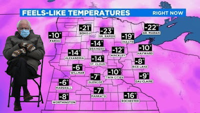
Bernie Meme That Broke The Internet Has Big Weather Following, Too

Here's Bernie, ready to provide today's weather forecast
The Bernie Sanders photo that launched a billion memes has also left its mark on the weather community.  

There are a lot of fun images on social media, Bernie with the big mittens, the no-nonsense Burton overcoat sitting in that chair, to keep weather geeks happy, too.

I shared some of the best memes, on my sister blog, Matt of All Trades, that you might want to check out. 

This,  however, is a weather blog, so here, we'll check out how Bernie and his mittens fare with the outdoor conditions. So, scroll on through below, and click on each image to make them bigger and easier to see. 

Also, please comment with some other great Bernie weather memes that I'm sure are out there. 

Did you know Bernie chases tornadoes? Two pics to prove it.  But you can tell he's not that impressed with them:


That's scorching weather in the desert, but again, Bernie's not impressed. The mittens don't come off until it reaches 120 degrees


The wind chills in Minnesota are getting low, but Bernie's prepared! 


Bernie is MUCH less enthusiastic about thundersnow than Jim Cantore


Halfway Point Of Winter In Vermont Brings First Real Introduction To Winter

After an almost nonexistent start to winter, it's definitely,
finally looking like the season around my 
hacienda in St. Albans, Vermont today.
Yes, the headline is a bit confusing, but it is accurate!  

Meteorologically speaking, we're at the halfway point of winter right around today. If you average everything out, today (or the days surrounding it) are the nadir of winter. 

It's the point of the season at which we should have endured half the subzero cold spells and winter storms Ma Nature will give us, and we have the other half to go. 

I'm talking about meteorological winter, I'll remind you. Astronomical winter started on December 20 and doesn't end until March 20.

By March 20, though, we should be warming up toward spring and by then, sugaring season I hope will be off to a rip-roaring start. 

This winter in Vermont, as we all know, has been an odd duck. Weather wise, it pretty much didn't even start until the past week or so, with several snowfalls and a turn toward colder weather. 

The forecast really does make it clear this winter starts now. The season will be back-ended, meaning the more intense part of the winter will be today and afterwards. "Intense" is a relative word here.  

It's going to get cold, as the chilliest air of the winter descends upon us in the next few days, but the frigid air will fall well short of the rock bottom chill we've seen in most past winters. 

Today, an Arctic cold front will bring what is forecast to be an intensifying line of snow squalls across Vermont. They'll sweep through starting near noon in the northwest and exiting out of Vermont in th south and east toward evening. 

You'll want to watch out for these, especially if you have to drive anyway.  If one heads you're way, everything will be fine on the roads, but an instant later, you're in heavy, blinding snow and the road ices up in an instant.   

My driveway in St. Albans, Vermont doesn't exactly look
like a snow canyon like it does in some winters, but
respectable snow banks are starting to take shape. 

If you know a snow squall is approaching, or you get an alert from the National Weather Service or other meteorologists,  it's best to stay put and not drive anywhere until after the squall passes and the salt shakers subsequently clear the roads. 

The snow squalls give us the chance of another one to three inches of accumulation today 

Then, it's on to the deeper chill, something we're not used to this winter. Snow showers will continue, especially along the western slopes through Saturday, but that won't be the main issue. 

The big story will be some long-lasting cold, which starts tonight and goes at least through next Thursday. 

High temperatures will be in the teens to maybe low 20s through the period, with lows a few degrees either side of zero.

This is only a little colder than normal, frankly, but we're not used to it, so the chill will come as a shock. Saturday will be especially nasty because of gusty northwest winds that will drive wind chills down into the minus teens. 

If you love big snowstorms during cold weather, it seems like you're out of luck.  A series of snowstorms will cross the nation roughly west to east over the next week or so. However, the cold high pressure from Canada that is lowering our temperatures in Vermont looks like it will shove the storms too far south to affect us. 

There's always a chance one of these storms could make a detour and give us some snow, but it's unlikely for sure.

Beyond next week, who knows?

However, as the weeks go by, you'll perhaps find that winter is losing some of its punch as the sun angle rises.

At the northern tip of Alaska, in the city of Utqiagvik, formerly Barrow, the sun will rise above the horizon today for the first time since November 18.  This hints at the rising sun angle. 

Eventually, not yet, but eventually, this increasing sun in the Arctic will damage the ability of the top of the world to generate ferocious Arctic outbreaks down where we live.

Vermont's second half of winter will almost certainly be colder than the first half, because it almost can't be any warmer than the first half. Early signs continue to point away from anything extreme heading into early February. 

Even if we do get some 20 below blasts in February, the rising sun angle will make the daytimes almost seem tolerable. 

The midway point of winter means, right now, you should be checking your seed catalogs and putting in your orders.  Spring is closer than you think.  

Thursday, January 21, 2021

"Dry" Weather Pattern Is Surprisingly Snowy In Vermont.

It's not the most snow I've ever seen on my weather deck
in St. Albans, Vermont. But repeated snowfalls, many
of them surprises, have left me with a snow depth
of 10 inches or so. Was snowing again when I took this pic.
 Well, I didn't expect that! 

I woke up to a fresh 2.4 inches of snow yesterday morning at my St. Albans, Vermont hacienda. I knew we'd have some flurries, and I was expected a dusting, but no bonafide gotta clear the driveway snow. 

So I shoveled, signed on into work, and glancing out my window, I saw that it started snowing again. A lot. That was good for another 2.5 inches of snow that needed shoveling. No worries, I needed the exercise. 

The bottom line was a hair under 5 inches of new snow that came on a day that less than an inch was forecast. It wasn't just St. Albans.  Up in Eden, they reported six inches of new snow in just three hours yesterday morning. Barton also collected six inches of snow by mid morning. 

Almost four inches fell in Milton, by 7:30 a.m. and that was before another burst of heavy snow blew through. 

After the weekend storm ended, Burlington got surprise snowfalls of 4.2 inches Monday and 2.6 inches yesterday. 

And, as I write this mid-morning Thursday, it is snowing once again. 

Where's all this unexpected snow coming from?

Small storms and disturbances zipping in from the west and northwest are the basic cause, but these weak little things aren't usually able to give us much more than a few flurries. Of course, some of these disturbances have had a little more oomph than usual, which helps wring out a little extra snow.

I have a feeling that the warm winter we've had is partly to blame, or credit depending upon your perspective. 

This winter's warmth hasn't been limited to just around here in Vermont. It's been warm across the Great Lakes, and in Quebec and Ontario. That has left much less ice on lakes in these areas than you'd expect in mid-January. 

I think that weak disturbance that are destined to give us light snow and flurries have been able to grab some moisture from the open waters of the Great Lakes, Lake Champlain, and some bodies of water to our northwest. 

This has helped enhance the snowfall. 

A lot of the accumulation has been fluffy too. Unlike the wet snow we had last weekend, the snow so far this week has been really fluffy, and does not have much water in it. The nearly seven inches of snow in Burlington since late Sunday night didn't even quite contain a third of an inch of liquid equivalent. 

"Dry" snow like this accumulates pretty fast, though it eventually settles quite a bit. 

Despite the lack of big storms, it looks like we're in for more snowfall. This morning's snow will tend to taper off a bit this afternoon, only to reblossom for a time tonight. 

A cold front tomorrow afternoon will set off even more snow showers, some locally heavy. Then, cold winds from the northwest will trigger even more snow Friday night and Saturday, mostly over the Green Mountains and western slopes. 

This will add up in the mountains.  Valleys should get one to four inches of new snow between now and Saturday evening, with locally higher amounts.  The Connecticut Valley could get even less than that. West and northwest winds tend to block moisture from places east of the Green Mountains. 

Those mountains, though, especially from Killington north, could wind up with an additional six to 12 inches by Saturday. 

Even drier, colder air should work in by this weekend, limiting snowfall for Sunday onward for a time. It looks like storms coming across the nation from the Southwest between now and the middle of next week will pass by too far south to bother us (Though I've been surprised before.......)

I can't say I'm really complaining about the snow.  Now, it looks like January out there, and the winter sports fan are surely gleeful about things. We're now all set for skiing, riding, snowshoeing and for snowmobiles. 

After a very slow start to winter, we're finally getting close to being up to snuff here in Vermont.