Showing posts with label weather pattern. Show all posts

Thursday, April 30, 2026

The Vermont Rain Has Arrived. So Has The Cooler Air. How Cool And How Much Rain?

This cluster of daffodils in my St. Albans, Vermont
garden, photographed yesterday, to me looks like
an audience in a theater waiting for the show to start
If the show was needed rain, it started overnight. 
 The rain arrive on schedule overnight in Vermont, but it looks like we're getting cheated out of a good soaking. Which is too bad, we needed it. 

'Don't get me wrong. What rain we're getting is extremely helpful. We don't have to worry about brush and forest fires today. 

 Things are rapidly greening up, and I noticed this morning the rain gave everything an added boost. It's noticeably greener looking out my window than it was even yesterday afternoon. 

The rain soaked northern New York nicely as it lingered there late yesterday and last night. The system will get reinvigorated as it enters eastern New England, so they'll get a good soaking. 

For us in Vermont. Pfft. Through 8 a.m. rainfall tolls were only around a tenth of an inch north and central, and a closer to a quarter inch south, give or take. 

This morning's weekly U.S. Drought Monitor has halted, at least for now, an improving trend we've seen this spring in Vermont. This morning's report extends drought that had been limited to a small area near White River Junction and Springfield all the way down the Connecticut River Valley to Brattleboro. 

Southern Vermont remains abnormally dry, while northern Vermont is still out of any trouble. I don't think we're going to return to the severe drought we had last summer and fall, but as Lynn Anderson sang, "Along with the sunshine, there's got to be a little rain sometime." 

It was still raining a little in northern Vermont as of 9 a.m. and showers should continue through the day. So what I gave you isn't the final totals.  We also still have an unsettled weather pattern to look forward to, but it doesn't look that wet, at least initially. 

THE SET UP

The cooler weather pattern is getting established, as we've been talking about all week. 

The core of the cooler air seems to want to mostly center itself near the Great Lakes. That region will be colder relative to average than we are here in Vermont. Forecasts can change, but for now, it looks like we'll  be cooler than average for a few days. 

We might temporarily get some near normal temperatures for early next week. Maybe even a couple degrees warmer than average if we're lucky. Then temperatures will probably slide back down toward slightly cooler than average later in the week.  

But it's not looking like we will get super cold for May. It's also appears we won't get much rain over the next few days. But the pace of that rainfall might pick up later next week. 

THE DETAILS

Today

Sorry if today is your only day off this week.  It's by far the worst weather day of the week.   The mild, sunny weather is so, so over. At least for awhile. 

Even it it doesn't rain much more today, skies will remain cloudy, there will always be a risk of a shower and temperatures should stay in the cool 50s. 

A few showers should keep going tonight, but they'll be mostly light and mostly in the hills and mountains. Some snow could fall above 2,000 feet in elevation, but it won't amount to much. 

Friday

Actually, not bad! We're a little more optimistic about tomorrow than we were earlier this week. We can expect a fair amount of sun, mixed with clouds especially over the mountains. There could be some isolated light showers, but they'll be brief and over or near the mountains. 

Highs should get into the low 50s for most  of us. That's about 10 degrees colder than average. Cold just ain't what it used to be earlier this spring. 

It's getting to the time of  year when forecasters mention frost and freezes. The National Weather Service regards May 1 as the start of the growing season in the Champlain Valley. With that, I'm guessing they could issue a frost advisory for the valley tomorrow night. The rest of Vermont won't see any advisories because the growing season there hasn't "officially" started.

But it will be in the low to mid 30s in the Champlain Valley and near 30 elsewhere. You'll want to take sensitive plants indoors. Whatever is growing in your perennial garden should be fine, though, despite the expected frost. 

Saturday/Sunday

Similar to Friday, but with a few more clouds in the afternoon and a slightly greater chance of light afternoon showers.  Sunday should also be partly sunny with a very slight chance of light showers, mainly over the hills. Highs should make it into the low and mid 50s both days.  So, an OK weekend, really. 

Next Week

The weather pattern will reinforce itself with a new Canadian cold front. South winds ahead of the front should warm us back up into the 60s.  A dip in the jet stream should stay centered near the Great Lakes next week ,hence the relatively colder air there.

This arrangement means there will be a south to southwest flow of air over us. That would slow down that cold front somewhere over the Northeast, 

For us, that means it won't be particularly warm, but the pattern  opens the door to small storms coming at us from the southwest. That might mean somewhat more substantial rains.  Nothing scary, but we have the potential for a needed soaker or two. Stay tuned to see whether that actually pans out. 

The dip in the jet stream might shift east somewhat later in the week, which would cool us in New England down again. 


Friday, April 10, 2026

Ma Nature Really Picking On Michigan For Some Reason

Ariel view of river flooding affected several houses
in Michigan recently. The state has really been socked
by several damaging, sometimes 
deadly storms this spring. 
Every once in awhile, a state or region gets stuck in a weather rut. Anything bad that could happen tends to strike that state. Over and over again. 

This year, especially since March, Michigan seems to have run afoul of Ma Nature's good graces 

The storms that got the most publicity - and were the most tragic - were the tornadoes across southern Michigan on March 6, killing four people and destroying neighborhoods. Especially in Three Rivers and Union City, Michigan. 

A new storm swept through Michigan last weekend, causing widespread flooding and dropping  a tornado. The twister last Saturday, April 4 in Van Burn Township, Wayne County in southeast Michigan. It was and EF-1 with winds of 100 mph and a path running three miles long. 

The flooding in the past week might be the worst of it all. There were dozens of incidents scattered across Michigan, mostly in the western, central and southern parts of the state. Dozens of homes received at least some damage. Especially along the Grand River in Michigan, which touched major flood stage. 

As in many spells of bad weather, Michigan residents last weekend saw a series of flood-related incidents that seemed to hopscotch across the state. 

Heavy rain flooded a large parking lot at an apartment complex in East Lansing, Michigan, destroying a few dozen cars.  It was unfortunately the third time in two years residents had their cars wrecked by flooding. 

The animal rescue group Detroit Animal Welfare Group in Macombe County, Michigan suffered severe flooding,

It took 16 hours to make sure all the animals had been moved to safe location, but on the bri Took 16 hours to get animals to safety at the 25 acre farm. 

A washout on railroad tracks in western Michigan forced Amtrak to suspend service between Grand Rapids and Chicago for several dahs. 

It wasn't just severe weather and flooding over the past month or so.

Easily one of the worst blizzards in Michigan history hit the Upper Peninsula on March 14-17. Some areas received up to four feet of snow. High winds piled the show into enormous drifts. Roads were shut down for days. 

On the southern edge of the blizzard, an ice storm cut power to 120,000 hones and businesses. 

The rough weather didn't stay in Michigan, since storms tend to be more far-ranging than just one state. Wisconsin, Ohio, Pennsylvania and western New York all had a brutal series of storms over the past few weeks. 

Western New York has had an especially tough go of it.   The first March tornado in the state since 1976 touched down on the 31st, and the town of Gowanda and surrounding areas suffered serious damage to homes, buildings and cars as thunderstorm winds of more than 70 mph drove torrents of hailstones bigger than golf balls through the area. 

Oneida Lake, a little northeast of Syracuse in New York, is flooding. Strong winds sent waves from the lake into homes in Sylvan Beach, New York, damaging several of them. Sea walls also collapsed under the onslaught. 

Back in Michigan, it's not over. Weather patterns during a particular season sometimes get "stuck."  In this case, a pool of very cold air - basically what's left of the winters polar vortex - has been swirling around near or north of Hudson Bay for weeks. 

Meanwhile, a broad southwesterly flow has helped pull warmth and moisture from the Gulf of Mexico. Where those two polar opposite types of air come closest to each other, you get storms. More often than not though the late winter and spring, that stormy air mass meeting spot has been in or near Michigan. 

That will still be more or less the case over the next week, though now that we're later into the spring, the warmer air is winning out in Michigan. Their biggest threats are severe storms and flooding over the next week or so. The worst of it appears as it it will be early next week. 

A rough, snowy winter and that March blizzard means there's still quite a bit of snow left on the ground on the state's Upper Peninsula. 

Warmer temperatures, rain and thunderstorms starting later in the weekend and continuing into next week will melt more snow and raise rivers to flood levels. (There was still three feet of snow on the ground in Marquette, Michigan as of Wednesday, so there's still a lot of snow to melt). 

Places like Wisconsin, Ohio, northwest Pennsylvania and western New York have been caught in this web of storms, too. But Michigan seems to be Ground Zero. Here in Vermont, we're on the outer eastern edge of this persistent storm track. That means we'll have a frequent chance of showers, but it doesn't look like we're under the gun for any extreme weather. 

Looking further ahead, wetter than normal conditions are expected in Michigan for at least the next two weeks, if not beyond that. 

Thursday, March 19, 2026

A Long Chilly Weather Slog Coming Up In Vermont

Since the weather won't be especially springlike over the
next two weeks, here's some greenery from a past spring.
Trust me, it will look like this in about six or seven weeks.
In many years here in Vermont I've seen some solid, warm hints of spring during March, only to fall into a cold, long slog of weather through late March and into April. It almost always happens.

This will be one of those years.

Granted, it won't be as had as some wintry early springs we've had in history. But you won't be basking in balmy summer rays anytime soon, either. 

SOME HISTORY

To make you feel better, I can give you some examples of how bad it has been, with reassurances it won't come close to being as miserable this time around. 

March/April 1919: On March 27 that year, the high temperature was 62 degrees in Burlington and the low was 50.  Delightfully springlike. Then it snowed for the next four days, totallng 19.1 inches. 

High temperatures - never mind low temperatures - were below freezing from March 29 through April 2. The high temperature on April 1 was 19 degrees. There's a horrible April Fool's Joke.

March/April1975: It was a supreme example of early spring awfulness. It got up to a respectable 54 degrees on March 25. Then, all but one of the next 14 days through April 10 never got as high as 40 degrees. Nine of those days never got above freezing. Measurable snow fell on eight of those days, totaling 13.5

Now that I've scared the hell out f you let's get into the reality of this spring.

THIS YEAR'S SETUP

There's always the possibility we could get a day or two over the next couple of weeks that are warm, but chances are good almost every day for the next two weeks will be near or below normal.

The record-shattering heat dome is in place out in the southwestern United States, sending temperatuers into the 100s there. On the east side of the heat dome, the jet stream and air flow come mostly from the northwest, sending repeated cold fronts and storms our way.

The rest of this week into the weekend will feature temperatures close to normal. OK, I guess. But the sky will be cloudy most of the time, and we'll also see chances of rain and/or snow most of the time. 

It looks like most if not all the storms over the next two weeks will be small to medium sized, but each one will bring probably bring both rain and snow to Vermont. 

THE DETAILS

Today

A weak disturbance was swinging through, bringing a few snow flurries to start the day. No biggie. It'll be warmer than the past couple of days, too, getting up to near 40.  That's close to average. There might be few light rain or snow showers overnight. Again, not a biggie.

Tomorrow

A somewhat more substantial storm will come in from the west. It won't be a huge thing, but the rain and snow will be more noticeable. And steadier, The precipitation - rain the low elevations will begin by afternoon. At this point the storm looks like it will aim slightly heavier precipitation at southern Vermont, but that could change. 

For now, rain or melted snow in the north will amount to a quarter inch, ranging to near a half inch far south. 

Tomorrow night, the rain will change to snow starting and mid and high elevations and reaching valley floors later. Those valleys will see very little accumulation, as temperatures will be slow to reach the freezing point. 

The higher elevations could pick up two or three inches of snow, with maybe something near six inches at the summits.  

Next Storm

This one is a bit of a wild card as the computer models are still fighting amongst themselves over the type of precipitation and the amount. 

At this point, it looks like a warm front will move through Sunday with snow quickly changing to rain. The rain looks like it could be fairly heavy with this one if everything comes together as some of the models suggest.

If the storm goes a little further south than expected, that would put more snow and mixed precipitation into play. Stay tuned on this one.

BEYOND SUNDAY

Next week looks like it will bring the core of our long chilly spell. Once again, it looks nothing like 1919 or 1975, thank gawd. Instead, most days will get into the 30s. A couple days might not even make it above freezing. 

If a storm during the middle of the week goes by to our north, we might have one day, or part of one dah of relatively mild weather. Don't worry, spring will get here eventually. 


Tuesday, March 17, 2026

Storm Departs, Cold Air Arrives; Here In Vermont 60s To Snow In Three Hours

It looked nice enough out my window this morning, but
it was very blustery and cold. Traditional March winds
are back and they sure aren't warm. 
 For the second time in a week, today's a day in Vermont that on paper looks like it was a nice spring day. However, it was   anything but. 

Much like last Thursday, some parts of the Green Mountain State were in the 60s just after midnight this morning. That sure as hell didn't last long.

In Burlington it was 65 degrees at 1 a.mo So mid-60s will be the high temperature for today.. An hour later, it was 40 degrees. It's was snowing a little by 4 a.m. 

The only thing that hasn't changed is the wind speed.  A wind advisory still exists until 11 a.m. today for gusts out of the west as high as 50 mph. 

Nearly 12,000 Vermont homes and businesses were without power at around 4 a.m., mostly due to the initial, stronger surges of wind with the cold front. As of 8 a.m., the number of those outages has been halved, so we're making progress. 

TODAY/TOMORROW

We've got a couple of really cold days for this time of year coming up. And we have no return to spring weather in the forecast - at least not for the next week to 10 days. Sorry to be such a gloomy Gus, but there you go. It's March in Vermont. Deal with it. 

It was still near 32 degrees across Vermont as of around 8 a.m. But those temperatures will stay steady or even slowly fall as we go through the day.  Those of us who got a thin scrim of snow from the cold front will get very little additional snow. However, some snow showers will roam the state, especially in the Green Mountains for the rest of today. 

Tonight, lows will drop to the upper single numbers to low teens, making it the coldest night since March. This is nowhere near record cold, but it's a chilly slap on the fast. 

Tomorrow won't be any warmer, but at least it won't be so windy. And it will be sunny.  A sunny 30-degree day in March feels better than a sunny 30-degree day at the end of December. A higher sun angle makes things feel a lot better.

The rest of the week into next week appears to be unsettled and chilly. We'll have a persistent northwest flow, with cooler than normal air and weak disturbances coming through pretty much every other ray with light rain an snow showers. 

This is the pattern we endured in much of the winter. We just can't seem to shake it for any longer than a week or so. I have no idea when it will end. At least normal temperatures are rising fast now, so it's getting harder and harder to get really cold.

Since we're getting into the second half of March, most days in this regime will get into the 30s to low 40s. That's better than the teens and low 20s for highs we had so often during the winter.

And someday, spring will get here.


Wednesday, January 14, 2026

Rain To Snow In Vermont Late Tonight/Tomorrow; Second Half Of January Looks REALLY Rough

National Weather Service snowfall prediction map for
late tonight and tomorrow. This is another big bust
potential map, especially in Vermont. We could end
up getting much more or much less snow than
depicted here. It depends on how quickly rain
will turn to snow early tomorrow, 
Today will pretty much be the last day of mild weather before winter returns to Vermont with a vengeance. 

We've had a series of warm days, so, at least as measured in Burlington, January so far is running about three degrees warmer than average. 

That's about to change soon.

It'll be cloudy and mild ahead of a cold front today, with highs once again  in the 30s to low 40s. Then trouble begins to arrive tonight. 

That's in the form of a wave of low pressure forming on the front.  We knew yesterday this would be the case. Now, it seems the storm will be going just a little further west than depicted in yesterday's forecast. 

That means northern New York should get most of the snow out of this. Current forecasts have folks across the pond getting three to 6.5 inches of snow.

The cold air will flood into Vermont as dawn breaks, changing our rain to snow. Meteorologists are struggling with how much snow Vermont will see out of this, as different computer models this morning are still giving highly different results.  

That's especially true in northwestern Vermont, where amounts really could range from one to eight inches. It'll probably be closer to two or three inches. But stay tuned, because this forecast could change a lot. 

By the time you get to southeastern Vermont, you likely won't see much snow out of this. Maybe an inch if you're lucky. 

No matter how much snow we get, tomorrow morning's drive time looks like a real mess. The temperature will crash and fast Water will be freezing on roads and sidewalks and snow will fall on top of that. Give yourself plenty of time to get to work or school tomorrow, or try to work from home. 

Temperatures will fall through the 20s and teens all day and gusty winds will make things feel worse. The snow should dwindle to snow showers during the day. By Friday morning, temperatures should be within a few degrees either side of zero for most of us. 

This will be the opening salvo of a pretty intense winter siege for us in Vermont, and for many people in the Upper Midwest, Northeast and southeast Canada. 

After a chilly Friday, we'll have one more mild day before the forces of the Arctic take over.   

FRIGID PATTERN

A schematic of the jet stream and air flow expected next
week. Click on the image to make it bigger and
easier to see. Follow the dark green lines from
near the North Pole southward through Canada 
and into the Great Lakes and Northeast. 
That shows how the air will be moving next
week. Since the air is coming from the North
Pole, be prepared to really bundle up. 
The overall weather pattern for the second half of January reminds me of the blockbuster winters of the 1970s.  

That pattern features a huge northward bulge in the jet stream near western North America and a sharp southward dip in the eastern half of the continent. 

Amid all this, the polar vortex, the whirl of frigid air that roams the Arctic all winter, is positioned closer to us than normal. In this case, roughly near Hudson Bay instead of way up by the North Pole.

The polar vortex is settling in near Hudson Bay because another Greenland block is shoving it there. The Greenland block, as you might recall from a previous post, is unusual high pressure and warm air (well, warm for them) around Greenland. 

In some winters, this happens repeatedly and is hard to dislodge. Apparently, this is one of those winters. 

Going forward, we'll have to deal with several blasts of frigid air, directly from the North Pole. There might be brief breaks of somewhat more reasonable air lasting a day or two before new Arctic cold fronts plunge through, bringing us back to Yukon style winter weather. 

It's hard to tell in advance precisely how cold this pattern will get for us, but it has the potential to be the most intense cold at least since the icy weather in February, 2015 or the rough winter of 2013-14. The worst case but possible scenario would be the coldest weather since the very frigid winters of 1993 and 1994.

This is definitely a shivery pattern for us, but will it be good for snow lovers?

The answer is mixed.

With each cold front coming down from the northern reaches of Canada, we'll see bouts of light snow and flurries. In other words, not much snow. 

If any of these northern cold fronts aligns with a storm way down near the Gulf of Mexico - this is called phasing - them we could see some blockbuster storms.  With phasing, very wet southern storms cooperate with cold, dry northern storms to produce systems that can drop a lot of snow.  

The best chance of this happening might be later in the month, when some forecasts have the center of the "dip" in the jet stream move slightly westward. That would give room for storms to race up the East Coast.

Only time will tell if that will actually come to pass.

As far as how long this upcoming frigid pattern will last, it's anybody's guess. From what I can tell, this could go into February. 

Saturday, December 6, 2025

Relentless Cold December Weather Shows No Sign Of Breaking For Weeks

Winter tossed down a few more snowflakes in St.
Albans, Vermont this morning. We're stuck in a
pretty intense cold weather pattern and there's
no real end in sight. 
I'll give you the grim news straight up:

We here in Vermont are locked in an awful, cold weather pattern, one with super-unusual persistence and one we are completely unused to, since recent winters have been so warm.

I feel like a doctor giving a bad diagnosis. But this is just cold winter weather, not something life-changing. It's all about perspective. 

In fact, though some of us are dreading the uncomfortable cold, the claustrophobia of not wanting to go outside and the high heating bills, other people are far less gloomy. I imagine a lot of people here in Vermont are cheering the prospect of continued great early season skiing and riding, and the prospect of one of the earliest starts to ice fishing season in recent memory. 

THE SETUP

In hindsight, we could see the first hints of this near-constant supply of cold air from Canada back in late October.  The pattern kept getting its act together more and more in November. Finally, now that we're in December it's a full blown Arctic weather regime. 

It's now looking more and more likely that we're stuck in the cold air perhaps through December at least. 

Sometimes, once a frigid pattern like this gets set up in the winter, you can't dislodge it for weeks and weeks. The last time we got into a stuck pattern like this, it lasted from mid-January to about early to mid-March, 2015.

Even then, the cold pattern of 2015 didn't completely break dow until around April Fool's Day. 

Sometimes, these patterns shut down abruptly. An extreme example came in late November and December, 1989.  That December turned out to be by far Vermont's  coldest on record. Then the pattern flipped.  January, 1990 ended up being the second warmest on record

The bottom line is, we don't know whether this is just a December thing, or something for the entire winter. My gut tells me January and February might not be quite as much on the cold side, but who knows? We'll see.

All we know is we'll generally be in this cold regime for at least the next two weeks. After that, the forecasts get very, very fuzzy.  

Not all outbreaks of cold air will be as intense as the one we had Thursday and Friday morning, which brought Vermont its coldest December weather in 36 years. But it will be cold most of the time. 

This is a case in which climate change is sort of our friend. True, we'll have some days that are much, much colder than normal, even by the chillier 20th century measure. But since the world is warmer than it was decades ago, chances are most of these blasts of frigid air won't be as intense as they would have been 50 or 100 years ago. 

This type of weather pattern is usually dry. Typically, you get a series of Alberta clippers that throw down an inch, two, maybe three inches of snow each time they come through. Each Alberta clipper introduces another shot of horribly cold air. 

Sometimes, snow lovers can get lucky in these cold patterns. Every once in awhile, one of these Alberta Clippers can hook up with a wetter storm to the south. They combine to form a nor'easter that can dump a lot of snow. 

Also, every once in awhile, a rogue storm might also go by to our west, giving a brief interlude of  relative warmth and mixed precipitation before the deep freeze resumes within a day or two.

 SPECIFIC FORECAST 

We're getting a semi-break in the cold today, as highs in the low 30s. That's still a little colder than average for this time of year, but not by much. There were some snow showers around northern Vermont this morning but they didn't amount to much. Some sun is working its way through, so today's your day for winter sports fun. 

The cold returns tomorrow, and that intensifies tomorrow night and Monday. Highs will be in the 20s Sunday, which is about ten degrees colder than average. 

A reinforcing shot of cold air Sunday night will throw down an inch or two of snow, maybe a tad more in the mountains as it comes through. 

It'll be in the single numbers by the time you get up Monday morning. The snow will be pretty much over, but of course the roads won't be perfect quite yet. After high temperatures only in the teens Monday, most of us in Vermont will get below zero again Monday night. 

It looks like a pair of those Alberta clippers will then come through next week, one on Wednesday and one on Friday. 

Instead of coming right at us from Alberta, these storms look like they'll  take a curving path down into the central Plains and southern Great Lakes, then head northeastward toward us.

That will enable each storm to pick up a little extra moisture and a bit of warmth. That could mean we get moderate snowfall out of each, and maybe some rain or an icy mix thrown in with them. It's too soon to know for sure, so we'll need to keep an eye on them. 

The second clipper seems to want to introduce a massive Arctic air outbreak that will arrive in the northwestern Plains Wednesday, then spread through most of the eastern two-thirds of the United States thereafter. 

That frigid air would arrive in Vermont Friday right after the second storm passes. 


Friday, November 14, 2025

Cold, Cloudy, Often Snowy Vermont November Revealing Some Quirks

Traffic cam image from yesterday afternoon shows
a lot of snow falling along Route 105 in Jay, Vermont.
If you think it's been a cold November in Vermont so far,  you're absolutely right. 

Through yesterday, the month is running 2.9 degrees cooler than normal, as measured in Burlington. 

Remember, that's the "new normal," based on the average of Novembers from 1990 to 2020. By then, climate change had really started taking hold. 

Average Novembers used to be colder than they are now. This month isn't coming anywhere near close to becoming among the chilliest on record. But we're surely noticing how wintry this month has been so far. 

Still, this chill is a departure from most recent Novembers, though 2019 was notably cold. On November 13 of that year, the temperature in Burlington fell to 9 degrees above zero, the coldest for so early in the season.

What's been notable this month so far are the comparatively warm nights. The coldest it's gotten in Burlington so far this month is 27 degrees. It usually gets at least that cold by Halloween. A spoiler, though: The forecast low in Burlington tonight is 24 degrees.

That's still not especially chilly for this time of year. 

SNOWY MOUNTAINS

It really, really snowed in the central and northern Green Mountains yesterday. I could tell something was happening up there from my perch here in St. Albans. It snowed all day here. Not hard, and it often mixed with rain, so our accumulation was just 0.2 inches. 

But just go a little higher in elevation than where I am at 650 or so feet, and things really started to pop with the snow. 

The snow depth atop Mount Mansfield by late yesterday afternoon was 22 inches. Since records started up there in 1954, only 1976 and 1990 had deeper snow at this date. 

I don't yet have any specific reports of snow accumulation from just yesterday, but I'm dying to find out how much Jay Peak got.

The early deep snow in the mountains doesn't necessarily mean we'll have a snowy winter. 

The winter of 1976-77 was a little snowier than average in Vermont, but had less snow than all the other winters in the particularly snowy 1970s winters.

The winter of 1990-91 in Burlington had just 42.5 inches of snow, far below the normal of 78 inches. 

FORECAST

The moist, cold northwest flow has dried up a little since yesterday, though we will see some scattered snow showers today. Again. Now that the snow has started, it doesn't seem to want to end. At least not everywhere. 

Most of whatever snow we get today will be in the mountains. 

However, the National Weather Service in South Burlington has flagged one interesting potential today. There might be a band of lake effect snow setting up off of Lake Champlain. It it happens, you might see it snowing it places like Charlotte, Ferrisburgh, Monkton and Hinesburg, that area. The snow band might jump all the way over the mountains to places around Rochester and Granville. 

Those places might get an inch of snow, maybe a tad more. 

When the Lake Champlain temperature is as warm as it is now, lake effect snows can drop a few inches of snow in the central and southern Champlain Valley. 

As mentioned, tonight could be the coldest night of the year so far, but that's not saying much. The reason: Skies might finally briefly, partially clear.  Clearer skies can mean colder nighttime temperatures. 

NWS South Burlington also says patchy freezing fog could develop toward morning. That'll leave a pretty frost on the trees, but can also create icy spots on roads. Especially on bridges and overpasses. Take care tomorrow morning if you're driving anywhere. 

Saturday 

Speaking of ice, we're still watching a storm due this weekend that threatens us with a nasty mix of snow, ice and rain. 

The timing of this storm has moved up a little, so now it will start to affect us tomorrow afternoon. It'll be cold enough so that it'll start as a nasty mix of snow, sleet, freezing rain and rain. 

It still looks like it'll be warm enough in the Champlain Valley so that most of this will probably be a cold rain. But along and east of the Green Mountains, freezing rain looks like it will hang tough. It won't be enough to wreck the trees, but certainly enough to make the roads very, very iffy. 

Keep that in mind if you're driving anywhere Saturday night, especially outside the Champlain Valley. 

There's still some questions about how this storm will sugar out. It'll probably move eastward near the Canadian border Saturday night, while a new storm gets going on the Maine coast. 

The interaction and exact paths of these storms will determine how much rain, mix and snow we get. 

The storm might be another installment, albeit a small one for continued drought relief. Right now, the forecast calls for roughly a half inch of rain, and melted snow and melted ice. 

Sunday and Beyond

The storminess will start to pass by us on Sunday and strengthen as it moves slowly into the Canadian Maritimes. 

That means another spell of cold northwest winds, lots of clouds, and snow showers. Those snow showers will once again mostly hit the central and northern Green Mountains. There could be a few more inches up there. 

Monday will be particularly windy and cold, but the chilly air will stand strong most of the week. It does look like it might finally warm up a bit toward the end of next week. 

The overall weather pattern looks active, with frequent chances of precipitation probably through to the end of the month.  

Wednesday, September 24, 2025

One More Nice Slug Of Rain Coming To Vermont Before Drought Returns

National Weather Service rainfall forecast map through
Friday morning. We hope it comes true, as it gives 
more than an inch of rain to southern Vermont and 
three quarters of an inch or so to the north. 
One bit of minor drought relief is behind us here in Vermont, and another dose of rain is coming. 

But as I said yesterday, this will do little to solve our drought problems.  

As has often been the case since early August, what little rain we got focused on northwest Vermont. Some areas there got more than half an inch By contrast, many areas in far southern Vermont received less than a tenth of an inch Tuesday, which pretty much does no good.

You can tell how ineffective yesterday's rains were. There's still a high fire danger in Vermont today, according to the Vermont Department of Forests, Parks and Recreation. 

Rains from tomorrow's storm should be more widely distributed than yesterday's mini storm.  I really hope the current forecast holds, because it gives close to 1.5 inches of rain through Friday morning in far southern Vermont and very roughly three quarters of an inch north.

That would put a small dent in the drought. However, we won't be able to see what kind of dent, if any, in the next weekly U.S. Drought Report, due out tomorrow.. That's because the data that goes into it ends on Tuesday. As noted, the rain yesterday would not have been enough to affect the drought one way or another. 

I think the report might end up showing a worsening situation, since there was no rain in Vermont leading up to Tuesday.  Of course, I'll do an update here tomorrow when that report comes out. 

FORECAST SPECIFICS

Many of us woke up to some dense fog this morning. The rain yesterday, combined with calm, humid air last night ensured the bad visibility on the roads when you were on the way to work this morning. 

The fog was burning off after sunrise. The rest of today will be kind of meh. 

Skies will be mostly cloudy, but with some breaks in the clouds, especially north. It will remain a little humid for this time of year. There could be a few showers, mainly south, but they won't amount to anything. Temperatures should reach the low 70s north, and maybe hold near the upper 60s south under somewhat thicker clouds. 

Tomorrow, a weak storm, but one with a nice slug of moisture with it, will come at us from the southwest and go almost directly overhead. Steady rains should blow in overnight tonight and continue tomorrow morning, and maybe into the afternoon. 

During the afternoon, the rain should turn more showery, but we're hoping there will be a lot of them. We might even see some local downpours and rumbles of thunder.  

We've been disappointed by weak rains so much, so I'm hesitant to get too optimistic. There's still time for things to go wrong and have the best rains miss us. But fingers crossed! 

GOING DRY AGAIN

Then, poof! The rain goes away. Seemingly forever. Our somewhat rainy week is turning out to be a brief blip in our dry weather pattern. That dry pattern returns enthusiastically this weekend.  

I suppose there might be a lingering shower Friday, but you'll barely notice it even if does rain. Then it's dry and warm again. We'll be back to lots of sunshine and low humidity starting Friday afternoon and going well into next week, 

Temperatures will be somewhat above normal as well. The warmer it is, the better evaporation you get, so even that's working against us. 

Meanwhile, something interesting might start to happen off the Southeast U.S. coast this weekend and early next week. It appears two tropical storms or even hurricanes might develop near and east of the Bahamas. 

When two such storms develop too close to each other, like what seems to be happening here, they do weird things. They can rotate around each other for awhile. The stronger of the two can absorb the weaker one. One or both can spin off and go in weird directions, 

This will give meteorologists major headaches trying to forecast what they will do.   Pass them the Tylenol, despite what President Trump might say about it.

The reason I even bring this up in this post is, we don't know how these storms might affect the U.S., if at all. As noted, it's too unpredictable. 

But the most certain part of this very uncertain forecast is that strong high pressure looks like it will deflect these storms well away from New England. Especially northern New England. 

I don't wish a hurricane on us, of course. But it would have been nice if one or both of these wannabe tropical storms flung some moisture our way. Miracles can happen, but it doesn't look like anything like that is in the cards.

Instead, it looks like Vermont will see almost no rain after tomorrow at least into mid-October. Oh, sure, some weak fronts might give us a little light rain from time to time between now and October 15. But so far at least, we have no more soakers after tomorrow, 

As I said yesterday, I hope I'm wrong about this!


Wednesday, July 23, 2025

Hot Times Coming Back To Vermont But It Probably Won't Last All That Long

The gardens around my shed and elsewhere on my
St. Albans, Vermont property are starting to take
on that ragged, late summer look as we head 
toward August. After more heat and humidity coming
in the next few days, another cool spell 
looks like it wants to welcome us into August.
 I hope you enjoyed another cool, crisp Vermont morning today, because it's back to the heat and humidity, for awhile, anyway. 

TODAY/TOMORROW

Today will still be reasonable, and actually perfect for summertime outdoor fun. The humidity will start to increase, but it really won't be all that bad. 

 So taking a hike or other outdoor activity won't necessarily kill you. But grab the sunscreen and the water to drink if you do go out to conquer Camels Hump or something like that. 

Temperatures under sunshine will get into the low or even mid 80s in many places, so it's a great beach day. 

Also, since winds will be light, no need to worry about dangerous conditions on the lakes. Though winds might be so light that sailboats might not work perfectly. But all in all, enjoy today. 

Because you won't necessarily like tomorrow. 

The humidity will surge in tonight. You'll notice it getting stuffy. And we've got at least one more 90 degree, oppressive day to get through. The record high tomorrow in Burlington is 95 degrees. We could get close to that, but chances are we'll just miss. 

In Montpelier, the record high of 89 tomorrow is in jeopardy. But St. Johnsbury's record high tomorrow of 95 looks safe.

On hot, humid days, we often have thunderstorms.  Not this time, though. The chances of storms Thursday are very, very low, due to lots of sinking air with high pressure nearby. I suppose one or two could briefly get going over the mountains, but those will be few and far between.

There might be some activity near the Canadian border in the evening. There's also a chance that people in northern Vermont might, maybe get a light show of potential heat lightning Thursday night from storms in Quebec. 

As a reminder, heat lightning is just regular lightning that's too far away for us to hear the thunder. 

FRIDAY

Friday could be a stormy day for some of us. A cold front will be slowly pressing down from Quebec. It all depends on the timing to determine how things go.

Anytime you get a cold front coming in during the day during hot, humid weather, you risk severe thunderstorms. 

If the cold front is a quickie, coming through earlier in the day,  northern Vermont might escape severe weather as the front will have passed. The slightly cooler more stable air behind the front would squash any wannabe thunderstorms. But northern areas would still get some rain out of the deal. 

 In this quicker case, southern Vermont would be under the gun for scattered severe weather, as storms will have a chance to build in the heat before the cold front finally makes its way to southern parts of the state in the afternoon,

If the front is slower, northern and central Vermont gets the storms. Southern Vermont would just be hot and humid again, as the storms wouldn't get there until evening, when they would be losing some of their punch. 

I hope we'll have a better bead on the front's timing by tomorrow, and whether there might be some strong storms and where. 

 FRIDAY-TUESDAY

There's not a lot of cooler air behind Friday's front, so summer weather should continue for awhile. Generally speaking, it will be warm, with highs in the 80s Saturday through Tuesday. Humidity will be moderately high. A disturbance could kick off a few showers and storms on Sunday, we'll see about that. 

On Tuesday, a stronger cold front will be approaching with its storms and rain.

And then....

AUTUMN RETURNS?

NOAA's outlook for early August has a strong signal
or leaning toward odds of cooler than average 
temperatures for at least few days 
There's a strong signal that next week's cold front - coming at us as July closes and August begins - could be another summer doozy, introducing a cool spell even chillier than the one we just had .

So much for the dog days of August. 

The forecast I've been mentioning stays the same. The heat dome in the middle and eastern part of the nation will migrate westward, allowing for a northwest flow to hit the northeastern United States. 

This looks like it will be an expansive break from summer heat, encompassing most of the Great Lakes area, Northeast and Middle Atlantic States.

It's a little soon to figure out how cool it will get, and how long the lower temperatures will last. But this could be a slightly nippier - and maybe longer lasting spell of uncharacteristically fresh summer weather. 

Early guesses point to about at least a good four days of cool weather. It's a long range forecast, so no promises. It'll be interesting to see how it works out. 

There's also still time for more hot, humid weather in mid-August and beyond, though. Don't expect summer to end next week. It'll probably be just a pause. 

Tuesday, May 13, 2025

Hot Times In Nation Continue For Now, But Chill Looms For North Later

Unprecedented May heat has touched off large forest
fires in northern Minnesota. Camps and other 
structures have reportedly been destroyed 
 The incredible heat wave in the Northern Plains continued Monday with a second day of blast furnace weather in places like North Dakota and Minnesota.  

Grand Forks, North Dakota turned "cooler" Monday with a high of 97 degrees, accompanied by wind gusts of 46 mph.  On Sunday, Grand Forks reached 99. 

Other readings Monday included 95 in Minot and Dickinson, North Dakota.  International Falls, Minnesota, on Monday had a high of 90 degrees and a low of 70.  

 That minimum temperature of 70 was four degrees warmer than any other low temperature recorded there in May.  

The weirdly hot, dry weather has sparked raging wildfires in northern Minnesota, burning through forests, camps and other structures. 

There's never been close to this much heat in the northern Plains this time of year. Until now. Absolutely incredible.

The unprecedented heat can't continue up in the Dakotas forever. Back in Grand Forks, they're expecting more record highs with a 95 forecast today and 92 Wednesday. By the end of the week, it's back to reality, with a high of 49 forecast for the North Dakota city on Saturday. 

The end of the gobsmacking heat in the northern Plains represents an upcoming change in the national weather pattern that will keep the northern half of the United States cool and parts of the South broiling. 

The heat won't go away. It'll just be squashed down into the southern United States. As noted yesterday, Texas will have record heat this week, which will spread into other states like Louisiana and Oklahoma by Wednesday. 

Meanwhile, high pressure in Canada will eventually push the jet stream further south into a generally west to east pattern across the central and northern United States. 

This will create a sharp contrast between steamy heat in the south and cool, unsettled weather to the north, practically coast to coast. 

Combine that contrast with storm systems riding that west to east jet stream and you're going to get outbreaks of severe weather and tornadoes in the Plains and Midwest.  

Starting tomorrow and probably continuing for a week or more, you'll hear of tornado and severe thunderstorm warnings popping up in various places, depending on where the storm of the day and weather fronts are.

This new pattern looks like it could last until near the end of the month. 

VERMONT EFFECTS

We're still going to have a warm week here in Vermont, as the new weather pattern will take time to take hold here.

Parts of Vermont just can't get through as many as two days without rain, as unexpected sprinkles hit parts of the state Monday. 

 A disturbance zipped through the Northeast Kingdom yesterday. While most of us enjoyed sunshine and temperatures in the 70s to around 80, the Northeast Kingdom held in the 60s under clouds and light showers. 

We're mostly back to the sunshine and warm temperatures statewide today and tomorrow.   At least it will be pleasantly warm, as the Northern Plains heat wave is not heading in our direction. 

We introduce a slight chance of showers Thursday, and they become likely Friday and Saturday. Those showers might last into Sunday as well. I don't expect a super soaker like last weekend, but chances are we'll get a decent amount rain. 

It will still be warm and bit humid toward the end of the week, so that might introduce thunderstorms. It's unclear at this point how widespread or intense they will be.  There won't be widespread severe storm outbreaks here like in the Midwest, but if things pull together right, there might be a couple strong ones thrown in. We'll see.

After Saturday, though, it looks like we'll need to wait quite awhile for more summer like weather in the Green Mountain State. Don't get me wrong, it won't turn frigid after this balmy week. But it won't be beach weather, either.  


Sunday, May 4, 2025

Tale Of Two Vermonts: Very Soggy South, Just Damp North

Don't worry, not another snowfall prediction map. This
one shows expected rainfall today through Wednesday
morning. Less than a quarter inch up by
 St. Albans, but nearly three inches down
by Brattleboro, so that's quite a range. 
Saturday marked the state of a long, damp, cloudy stretch in the Green Mountain State. 

But things will be very different north to south. Starting today and through most of the week,  you're going to see a very soggy southern Vermont, while people up north will just dodge occasional raindrops.

Northern areas will probably trend a little warmer than southern Vermont, too, as less rain means more (mostly failed) attempts for the sun to break through the clouds in the coming days.

Unfortunately, it's going to be awhile before any of us in Vermont see wall to wall spring sunshine. 

SATURDAY REVIEW

Northern Vermont has started this episode a little wet, anyway. Saturday and overnight, rain fell statewide from the Canadian border all they way to Massachusetts and beyond.  

On Saturday, we were watching for the risk of severe storms in far southern Vermont, and that part of the state had the first severe thunderstorm watch of the season.

The storms ended up just barely clipping the southeast corner of the state down by Vernon and Brattleboro. No damage was reported there, but it came really close. 

Jaffrey, New Hampshire, not all that far from Brattleboro had quarter-sized hail. Thunderstorm winds gusted to 65 mph in central Massachusetts.

THE FORECAST

Going forward, the chances for severe thunderstorms are low, though there might be some storms here and there later in the week. 

The main story will be the rain, mainly south.

It's going to be tricky today through Tuesday and maybe Wednesday to determine how far north the rain gets and how heavy it will come down and where. But, again, the further south you are, the wetter you'll be.

Today

It'll be a big battle between that sluggish upper level low in the Ohio Valley flinging Atlantic moisture up north toward us, and dry high pressure in Canada trying to bleed in a little dry air from the north. 

The moisture will mostly win out.  

The morning light rain in northern Vermont this morning seems like it might taper off, with areas near the Canadian border maybe staying dry this afternoon.

The further south you go, the more likely you are to be wet. The southern part of Vermont will likely have a drab, washout Sunday.

Still, forecasters this morning were still not absolutely sure how far north the rain will stay this afternoon. So bring the rain gear no matter where you are in Vermont today, just in case.

If the rain holds off far north this afternoon, it will get into the 60s there. Under the rain, chilly damp 50s should do it south of Route 2.  

Monday

The dry air wins out a little, so even in southern Vermont the rain should at least be lighter. Far northern Vermont might actually squeeze out a decent day, with a low chance of rain perhaps some breaks in the clouds and temperatures getting well into the 60s

Tuesday and Beyond

As always, things look a little more questionable later in the week. The heaviest rain should stay in southern Vermont, but there are decent chances of rain north, too. Like I said, it's be a damp week. 

Toward the end of the week and next weekend, it's unclear whether more sluggish weather systems will keep us cloudy, or whether we're finally able to clear out.  It'll probably  get cooler at the end of the week.  If overnight skies clear out Thursday and Friday there could be some frost, so we'll keep an eye on that.   

Thursday, February 6, 2025

Vermont Thursday Snow Thump Set To Arrive; Sunday Storm To Focus On Southern Parts Of State?

A gray an ominous sky over St. Albans, Vermont this
morning as we await that quick thump of snow that
will come through midday. A little freezing drizzle
later today will be the literal icing on the cake.
UPDATE 9:30 a.m

Boy, that snow came into Vermont awfully fast, faster than I thought it would.

At 9 a.m. I could see a wall of snow just blotting out the Adirondacks from my viewing point in St. Albans, Vermont.

By 9:15 it was starting to snow, and by 9:25  a.m. it was coming down at a good clip.

Radar seems to show the band of snow might wax and wane as it comes through, but you'll see bursts of heavy snow and poor visibility on the roads.

Sometimes the snow will come down torrentially.   Traffic cams showed near white out conditions at 9:25 a.m. in places like Route 7 in Shaftesbury and Route 9 in Woodford, both in southern Vermont.

Those road conditions should deteriorate awfully fast in the next hour, if they haven't already. If you're on the roads, I'd get home now and wait it out. If it's not snowing where you are, it'll go from nothing to pretty heavy within 10 minutes. At least in some areas if not all.

Be prepared for a very snowy few hours, but it won't last long.

PREVIOUS DISCUSSION 

 Skies were growing dark and ominous in Vermont as that anticipated quick thump of snow rapidly approaches from the southwest. 

Looks like the snow was just creeping into far southwest Vermont at around 8 a.m. and it will rapidly advance northeastward through the morning. 

At least the snow will warm us up. It was another frigid one before dawn today. Burlington in the banana belt managed to stay just above zero with an overnight low of 1 degrees.

 Elsewhere, it was 8 below in Montpelier and as low as 13 below in Morrisville and Lake Eden. 

You can see how the push of snow will eventually warm us up by looking at Bennington. It was 5 above there at 5 a.m. and up to 22 at 7 a.m. 

The snow still looks like it'll come down pretty hard late this morning and early afternoon, but will be in and out of here in a flash - like four hours or so.  That's why accumulations will be limited to one to three inches, or maybe four in some of the mountains and in a few parts of southern Vermont. 

Forecasters also haven't budged from their expectation we'll see some spotty freezing drizzle this afternoon and evening once the band of snow races out of here.  Temperatures look like they'll hold steady or even keep rising slowly late this afternoon through about midnight. 

This mornings snowfall prediction map for today. Aside
from adding a tiny bit more snow than previously
expected in southern Vermont, the forecast is pretty
much the same as that issued yesterday. 

Your drive home this afternoon or evening still looks like it could be dicey 

Warmer towns could get a couple degrees above freezing this evening.  But the ground is frigid from those cold nights. 

Even if your thermometer ends up saying it's 34 degrees out, any drizzle you're also seeing will probably be freezing onto your driveway and sidewalk. 

Overnight, the storm's inevitable cold front comes in with its snow showers and local squalls. Accumulations won't amount to much, but will keep some roads tricky for Friday morning. 

We'll have the added fun of some lingering snow showers (especially mountains) and blowing snow as west winds will start gusting to 30 or even 40 mph in spot starting early Friday morning and lasting pretty much all day.  Gusts could even reach higher than that in spots across northern New York and near some of the eastern slopes of the Green Mountains. 

Temperatures will be seasonably cold Friday and Saturday with highs in the 20s, lows in the single numbers

 NEXT STORM

It still looks like it will snow pretty much statewide later Saturday night and Sunday, but it's increasingly looking like this will be a southern Vermont focus.

Through virtually all of December and January, southern Vermont has missed out on snowfalls. They've mostly focused on northern Vermont mountains.

Now, the script seems to have flipped as the weather pattern is a new one that features storms racing across the nation and going off the East Coast.  Those tend to favor southern Vermont. 

Last Friday night, southern Vermont got a decent snowfall while the north missed out. Today's event looks slightly more impressive in the south than in the north.  

The early look on this Sunday's storm suggests six or more inches of snow south of Route 4, with less than five inches north of Route 2.   Now, this could change. The storm could jog north and give everybody in Vermont a big dump.   But as of this morning, the betting is on the south. 

This new southern bias in the snow is a good thing really. The effects of last autumn's drought are still most noticeable in southern Vermont. All that snow melting in the spring will help recharge ground water for the spring and summer. 

Like all the other storms in this parade, the Saturday night/Sunday system looks like it will race past us, so it won't have time to dump incredible amounts of snow.  But these things add up if you keep getting them over and over again. 

Long range forecasts have fast storms coming near us every third day or so.  It's impossible to tell from this vantage point how those quick hitters will affect us here in Vermont, but forecasters will need to really remain on their toes, probably for at least most of this month. 

I also so far don't see any signs of a huge thaw, which is a departure from recent winters.  It has not been above 45 degrees in Burlington since December 31, and it doesn't look like it will get that warm for awhile yet. Whatever snow you have is going to mostly stick around, and you're also going to get more installments. 

Keep those shovels handy. 


Monday, February 3, 2025

Signs Beginning To Point To Possibly Snowier Vermont February Regime

The next round of snow, which could begin as rain later
this afternoon, will focus on the north and mountains
again. A number of places north of Route 2 will
see three to six inches of new snow. Areas
near Burlington should get less than that, and 
far southern Vermont will probably miss out.
This forecast has a high bust potential due to
questions about temperatures when things hit.
As we've previously reported, snowfall has been lacking in Vermont, except for in some areas in the central and northern Green Mountains. 

Signs point toward a snowier February regime in the Green Mountain State, but there's no guarantee and plenty of questions. 

We do know that the weather pattern has become stormier, and chances are it will stay that way for awhile.

  As I noted Sunday, a  new weather pattern that puts Vermont in a battleground between springlike warmth from the South and Arctic air from the north will probably steer storms toward us.

On top of this, long range forecast guidance has trended colder here in northern New England. If that pattern holds - and I admit that's a pretty big if - storms would pass near Vermont or just to our south. 

That would provide us plenty of snow or worse, mixed precipitation this month. More on that in a bit. 

Our first installment of snow came through overnight, with our expected one to three inches of rather fluffy snow. I had an even two inches here in St. Albans, Vermont.

TODAY/TOMORROW

The next little installment of precipitation isn't going to be so easy.  We have a break in the snow today, and most of us will have that mini-thaw that we've been expecting. Most of us will see highs well into the 30s to near 40. .

That complicates your trip home from work this evening. A cold front will be coming in with its own band of precipitation.  In warmer valleys, it'll start off as a cold rain, then gradually mix with and  change to snow. 

In northwestern Vermont and along the Canadian border, and in many higher elevations, it might be all snow, or at worst start off as a mix of rain and snow. Even though this is happening today, I'm still seeing a lot of questions as to how much rain vs. how much snow, and when the changeover to snow might happen.  

It's going to be marginal between rain and snow in many places, even in the north, late this afternoon and perhaps early this evening. It's a tricky forecast. If rain dominates longer, we obviously won't see as much snow. If the snow wins out more than expected, we could see a little more.

If things work out and time themselves poorly, this will be a mess for those driving home late this afternoon. That slushy, wet snow tends to be particularly slick. I've also noticed many people behind the wheel think slush is just glorified water and you can speed right through. That leads to crashes and slide offs. More joy on the highway. 

The snow this evening will tend to be wet and heavy, which is a departure from the kind of snow we've seen all winter.  Later on, the snow will turn fluffier. 

Overall, accumulations look to be about 2.5 to 6 inches north of Route 2 in Vermont (though less than that near Burlington, where one or two inches looks more likely). A winter weather advisory is in effect for the Vermont and New York counties adjacent to the Canadian border, with the Champlain Valley excluded from that 

It looks like far southern Vermont will get nothing, or just a dusting out of this one, since most of the good moisture - be it rain or snow - will slide by to the north of those areas. . 

The snow will have ended by Tuesday morning, but there probably will be some lingering headaches on the highways for your blissful morning commute. 

WEDNESDAY/THURSDAY

Wednesday should be dry and cold as our temperature roller coaster continues on unabated. 

The next storm comes along Thursday. It looks like we're going to continue the trend of getting mixed precipitation into the forecast.

It's not a blockbuster, but chances are it will be messy.    Computer models are not agreeing well on this storm at all, so we're going to have to wait for updates to get any smidge of certainty. 

It could end up being a snow to mix to rain scenario if the storm goes to our northwest and another storm doesn't form along the coast. Or the storm could come closer to us, or something real could get going in eastern New England.  That would keep is in a mix of snow and maybe freezing rain, too.

Either way, it looks ugly. But who knows? The storm might surprise us with a third option we're not aware of yet.  Watch this space. 

LATER THIS MONTH

Something else seems likely to come along around Sunday. Forecasts now are leaning toward snow, but there's still a lot of question marks about that, too.  Beyond that, early indications are the weather pattern will stay busy for us through midmonth at least. 

I have seen a pattern in many recent years in which winter snowfall in Vermont is back loaded - meaning the bulk of it has been coming in February, March and April.  It's not every year, and I don't know why it's happening, but it seems to be a bit of a trend. 

Last year, a little more than half the season's snow total came in February, March and April. True, the total of 60.8 inches was below normal, but you get the idea.

Anything could happen of course. But it'll be a long wait before winter storms are no longer a concern in Vermont.  Give it until later in April, at least


Friday, January 3, 2025

Vermont/New England In For A Long, Cold Blustery Week Or More, Mountain Snows Continue

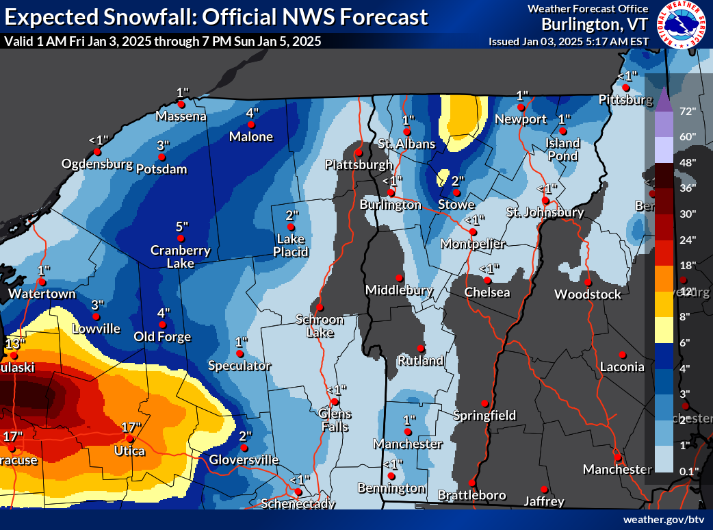
Not much snow this weekend for most of us, but notice the
eight inch expected totals in the northern Green Mountains
of Vermont. Plus the elephant in the room, the expected
three feet of snow downwind of Lake Ontario 
north of Syracuse, New York. 
If you liked the weather in Vermont yesterday, you're going to love the next week or more. Especially if you prefer it much colder than it is now. 

The cold air is coming in, but it's taking its time, despite the rushes of north winds we've been feeling. 

Winds as expected gusted to more than 40 mph Thursday but the temperatures didn't drop quite as quickly as anticipated. 

Burlington stayed above freezing until around 6 p.m. Thursday and most of us were still solidly in the 20s this morning. 

CHILL DEEPENS

 This January is shaping up to be much like 2022. That one also had  warm first couple of days but turned out to be another exception in our past decade or two of warm winter months.

The temperature will keep falling. Starting tomorrow and lasting at least a week, it's going to be persistently cold. Not extremely frigid, but the chill will have staying power. Highs will be in the teens to around 20, with lows in the single numbers to low teens through next Thursday and very likely beyond that. 

WPTZ Chief Meteorologist Tyler Jankowski noted on Facebook Thursday that the forecast for January 4 through 12 is the coldest since 2004. 

 Still, this won't be nearly as cold as some of the notorious Arctic blasts Vermont endured in the 1960s, 1970s and early 1980s. An example: On January 4, 1981, the low temperature in Burlington was minus 27 and the "high" temperature made it all the way up to (check notes) 13 below. 

Only a few places in Vermont were getting snow this 
morning, but traffic cam grab showed it was still
snowing and blowing along Route 58 in Lowell. 
The forecast low for January 4, 2025 is 13 above with a high of 20. So you see the difference. 

The weather maps for the next week look almost the same in our neck of the woods pretty much daily, which is a long time to go with no substantial change.

Every day for the foreseeable future will have that chill, along with lots of clouds and, almost a constant stiff northwest wind. The wind might relax a bit on Monday, but come roaring back afterwards

SNOW CHANCES

The strong, persistent northwest flow from Canada will suppress a pretty strong winter storm far to our south Sunday and Monday. That storm will eventually head way out to sea, then move north, intensify and stall near Labrador next week, keeping the cold winds over us going. 

Our only snow chances will come from moisture wrapping around that storm, and weak little disturbances riding that air flow from the northwest. I also think we might be getting a little moisture from Hudson Bay, which is usually frozen by now.   But there's still some open water up there, so that is probably adding a few extra snowflakes to the mix.

With the current weather pattern, Hudson Bay should finish freezing up soon, though. 

A strong lake effect snow band Thursday with some incredible staying power came off of Lake Ontario well south of Watertown, and held together pretty well as it clipped the southwest corner in Vermont. Its staying power extended all the way to and off the coastline of Rhode Island in the form of scattered snow showers. 

Traffic cam grab along high elevation Route 17 in Buels Gore
shows sun breaking through after fresh snow. Unsure
if that stuff that looks like steam in the background is
blowing snow or snow making at nearby ski areas.

Those lake effect snows are expected to dump up to three feet of snow mostly north of Syracuse, New York through the weekend. The snows from Lake Ontario will probably continue to reach parts of Vermont as light snow showers through the weekend, too. 

This is all good news for snow lovers in the mountains, but it means valleys will continue to see very little of it.

It will be interesting to get updates today on how much snow fell in the northern Green Mountains since yesterday

As of midday Thursday, 11.5 inches of snow had been reported at a 3,000 foot elevation in Underhill, and at another high elevation in Belvedere Center, with 10 inches in Braintree.

Even the southern Green Mountains got into the act with nine inches in Ludlow and eight inches in East Wallingford.

The snow in Vermont looks like it will keep piling up slowly in the mountains and mostly avoiding the valleys. 

The northern Greens can expect locally up to eight inches of additional snow between now and Sunday. More snow will surely fall up in the mountains much of next week.

In the valleys, nothing more than flurries and bursts of light snow. Eventually, even in the Champlain Valley, I imagine there we'd end up with a thin covering of snow, but nothing spectacular.  

Unlike the wild storminess of early January last year, the first half of January, 2025 is looking rather quiet and cold. 

Wednesday, July 17, 2024

Vermont Mostly Spared From Dangerous Line Of Storms, One More Humid, Stormy Day Then Relief

A badly damaged church in Rome, New York
after a tornado hit the city Tuesday.
Photo from Courtney Finnerty via 
Facebook.
 
 A wildly dangerous intense line of storms crossed New York State Tuesday, causing tornadoes, wind damage and flooding. 

Vermont got pretty lucky. Just as that line of storms entered southern and central Vermont, it weakened a little, sparing us from major damage and flooding. 

Yes, there were problems. Trees came down in Danby, Springfield and a handful of other southern Vermont towns. 

Close to 5,000 Vermont homes and businesses lost electricity. Flood alerts popped up i parts of Addison and Rutland counties, and I'm sure there were some instances of relatively minor road and driveway damage.

But it was a close miss, considering what happened in neighboring New York. 

Radar images pretty much confirmed a tornado touchdowns in four places between Rome, New York and just west of Lake George. Winds gusted to 87 mph in nearby Glens Falls, New York. 

The tornado in Rome, New York caused major damage to the city's downtown and nearby neighborhoods. Two churches lost large sections of their roofs, the Capitol Theater in Rome had its windows blown out, and an iconic mural in town was destroyed. Photos on Facebook showed many homes, apartment buildings and businesses with collapsed walls, destroyed roofs and shattered windows

Winds gusted to 79 mph at nearby Griffiss Air Field, and a B-52 at the entrance to the Air Force base was blown several feet off its platform. 

So you see, Vermont really dodged a bullet. Let's see if we can do it again today

HOT AND STORMY

Clouds and an approaching cold front will temper the heat today in the northwestern part of Vermont this afternoon, but the southern and eastern half faces another hot one.

Lebanon, New Hampshire, just across the river from White River Junction, has now had an astounding 11 consecutive days with temperatures of 90 degrees or more. They might do it one more time today. 

Nights have been torturous in Vermont as well. Burlington has had 13 days in which the overnight low was 66 or above, with five of those nights not dipping below 70.

Today's the last day of it, but we'll need to deal with more storm and isolated flash flood risks.  

Some scattered showers and storms were beginning to form in New York State ahead of the cold front by mid-morning.

They'll grow stronger and more organized as they head into Vermont. The more south and east you go in Vermont today, the more likely you are to see locally strong to severe storms. That's because they'll be able to take advantage of more heat in the atmosphere by afternoon. That created more instability.

The risk is locally damaging winds, but most places won't see that. We'll probably see isolated reports of tree damage and downed power lines, especially in Vermont's southern most two counties.

The storms will be moving right along, which means chances are it won't rain for too long in any given spot.

But since the ground is sodden and unstable in many places in the northern half of the state, we could see a couple instances of renewed flash flooding, especially if any particular storm is a bit more persistent the others

There's still plenty of water in the atmosphere, so any storm can produce torrential rains. You know the drill by now, right?

THE RELIEF

The dry, refreshing air is lagging behind the cold front a bit. So we won't really begin to feel it until after midnight tonight, at least, and probably not until tomorrow morning. 

But don't worry, we're still in the path of an upcoming air flow from the northwest. That will bring dry air into Vermont for an extended stay - at least through Monday.   The coolest days appear to be tomorrow, and Sunday, when we get hit by a reinforcing shots of Canadian air. 

In between, Saturday might prove to be a warm one, possibly reaching well into the 80s in some spots. but the humidity will stay down regardless.  

The overall pattern does seems to suggest more air coming at us from the northwest   - at least occasionally - through the end of the month. So we might have more opportunities between now and the beginning of August 

But it won't be constant pleasant air. Some shots of humid, possibly hot air will intrude from time to time between cold fronts. It is summer, after all. 


Monday, May 20, 2024

Houston Recovery: Heat, Bad Air Quality, Power Outages In The Way

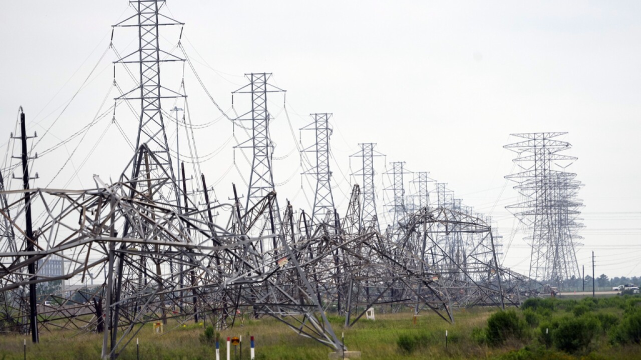
Collapsed power transmission towers after last week's
extreme storm in Houston, Texas. 
 I would say Houston is having almost the worst possible weather to recover from that amazing, incredibly destructive storm on Thursday. 

Heat and humidity is building in eastern Texas, making clean up harder and more dangerous.  People without power are dealing with this without air conditioning. Those with health problems are at risk because of this. 

As of late Sunday, about 260,000 homes and businesses were still without power in the Houston area. It might take all week for some of them to get the juice flowing again.  In this situation, it seems you alway find one outrageous incident, and here's Houston's.

A residential complex for elderly and disabled people was already in disrepair when the storm hit. It caused added damage to the facility at cut off electricity. 

KHOU said management abandoned the 260 or so residents, who did not have electricity, air conditioning, food, ice or other necessities from the time Thursday's storm hit until Sunday. That's when the city's mayor and fire department got wind of the situation. Two people were taken to a hospital, and the city brought ice, water and food. The local utility restored electricity to the complex later Sunday. 

People could have died. Houston Mayor John Whitmire vowed to go after the complex owners and managers. Let's hope he follows through. 

The only bright spot is no additional severe storms are in the forecast for at least the next week. Even so, many rivers in the general Houston area remain well above  flood stage. 

National Weather Service meteorologists did their investigations of the storm. They found most of the damage in and around Houston was from intense straight line winds. Part of downtown Houston, where windows were blown out of skyscrapers had winds of 100 mph, says the National Weather Service office in Houston. 

There was at least one embedded tornado in Thursday's mess. It hit the community of Cypress, a little northwest of Houston. Several homes suffered extensive damage from the tornado's winds, which reached an estimated 110 mph. 

The storm system turned into a derecho - a long lasting line of severe thunderstorms that overnight Thursday knicked the Gulf coastline before smacking into Florida Friday. 

That these storms hit so hard was partly due to a dome of extreme heat smothering Mexico, Central America and parts of the Caribbean. 

When you get these heat domes, clusters of severe thunderstorms often rid along the curving northern edge of the giant blob of heat.  These "ridge runners" as the batches of severe storms are often called, often cause trouble in the Plains, Midwest and sometimes the Northeast and Mid-Atlantic States during the summer. 

The heat dome that contributed to the derecho is dangerous in and of itself. All time record high temperatures for this time of year have been reported from  Central America to Florida. Belize had its hottest day in that country's history, reaching as high as 108 degrees

Water temperatures there have already warmed up to levels usually not reached until August. 

The record heat near the Caribbean Sea might have implications for the upcoming hurricane season.

The hotter the water, the more fuel for any hurricanes that drift into the Caribbean Sea. If any of those hurricanes on steroids reach land, there'd be hell to pay, as you'd imagine. 

Which means, places that got hit by the derecho and other highly destructive storms this spring from Texas to Florida might face even bigger devastating storms later this year.