Showing posts with label cooler. Show all posts

Thursday, May 28, 2026

Yes, It's A Cold Shot Coming To New England, But Not THAT Cold

I always post National Weather Service snowfall prediction
maps in the winter. I couldn't resist posting their snowfall
forecast for this weekend. As you can see, an inch or less
is expected in the high elevations, with maybe a couple
inches atop Mount Marcy, New York. 
 I've been hyping up the so-called cold snap and mountaintop snows coming Friday night and Saturday morning, but we actually should't complain. The weather over the next few days in Vermont really won't be that awful. 

Even Saturday won't be a total disaster. 

It's true that yesterday was the last warmer than normal day we'll see in Vermont for awhile. But this time of year, it can get dreadfully hot and humid.  We don't have to worry about that! 

In the past, it's also gotten much colder than what we're expecting this weekend.  For instance, the record low high temperature on Saturday in Burlington is 50 degrees. The forecast high is 59. 

Instead of all that, outdoor temperatures will be comfortably in 60s daily today through next Tuesday, except for Saturday. And there's no chance of frost except maybe in the coldest hollows of the Northeast Kingdom

We'll call today and tomorrow partly to variably cloudy with just a chance of isolated showers. It will be dry most of the time. Later Friday afternoon will tend to cloud up with a rising chance of showers north as our fast moving "bowling ball" of cold air comes toward us, fresh from the  Arctic Circle. 

THE COLD AIR

The pool of cold air will be over us mostly overnight Friday and Sunday morning. That's when the bulk of the rain (and snow!) will fall. There will probably be a dusting of snow at elevations above 3,500 feet and in higher elevations of the Northeast Kingdom. 

Rainfall for us valley dwellers will vary a lot, with less than a quarter inch south, a third of an inch maybe in the Champlain Valley, a half inch north and east of Interstate 89 and maybe more than three quarters of an inch in the Northeast Kingdom.

Saturday morning will certainly be cold and raw, but some breaks of sun will make things OK in many areas by mid to late afternoon.

SUNDAY-TUESDAY AND BEYOND

Those highs in the 60s during this period will be about five to 10 degrees cooler than average, but well take it. We'll have periods of sun, but also the risk of showers. So it will be the run inside when the rain hits, and a half hour later, it's back outside into the sunshine. t's hard to time out when, those showers might arrive, but the best chance is probably Sunday night and Monday. 

For those of you who like warm summer weather and dislike this cool stuff, there's hope for you, too. The weather pattern will start to change during the middle of next week, and it looks like we'll have at least spells of average to somewhat warmer than average temperatures starting the second half of next week. 

The usual caveat applies: Long range forecasts are iffy, so no promises! 

Tuesday, May 19, 2026

Flash Heat Wave Monday, Questions About Heat And Storms Today, Then Sharply Cooler Late Week

NOAA's Storm Prediction Center still extends their
slight risk of severe thunderstorms into Vermont.
(Everything in yellow is a slight risk).
That was a wild weather ride on Monday! 

Northern Vermont in particular endured the day's weather whiplash. As I noted in yesterday morning's post, the day began stormy and cold with fitful downpours, local gusty winds and even a rumble or two of thunder. 

Burlington reached 90 degrees by late afternoon, after a rainy early morning low of 51 degrees. By afternoon, we were sweating in a brief May heat wave that is already over-performing. 

I saw somewhere on social media where somebody in Vermont said they ran their furnace in the morning and air conditioner in the afternoon.

I'd call it a flash heat wave. Like a sudden flash flood, only hot air, not water. 

The day featured a rare temperature stat: Burlington had its first 80 degree temperature of the season Sunday. And only a day later, the first 90 of the season hit.  The same thing happened in April, 2002, but I wonder if this week and 2002 were the only times something like that happened. 

There has always been the occasional May in Burlington in which the temperature hit 90. But probably at least in part due to climate change, 90 degree May days are getting more common. In the 109 years in Burlington ending in 2009, we had 14 Mays that reached at least 90 degrees.

But in the 16 years since 2010, there have already been eight such days in May.  

Elsewhere in Vermont, the high in Bennington Monday was 89 degrees. Montpelier reached 86 degrees after a morning low of 46.  A temperature change of 40 degrees in just one day is pretty wild. 

The heat isn't only a Vermont thing, of course. Philadelphia reached 96 degrees Monday, a record for the date. It was also the second hottest May temperature on record.  In New York City, a high of 95 is expected today, followed by an incredibly stuffy overnight low tonight of 77. It should hit 90 degrees in the Big Apple again tomorrow. 

Heat advisories are in effect for much of southern New England and the Mid-Atlantic states. Hartford, Connecticut had its second day in a row of 90 degree temperatures Monday. Today's forecast high there is a whopping 96 degrees. The forecast high in Springfield today is 97.

VERMONT FORECAST

Back here in Vermont, the degree of heat today will depend on the level of cloud cover.  Severe thunderstorms are also possible, but there might be factors that allow us to luck out and avoid the worst of the storms. Maybe. 

We're certainly off to a very warm, muggy start. It looks like the low temperature this morning in Burlington was 71 degrees, so if you didn't sleep well in the Champlain Valley, that's why. If that low temperature holds through midnight, it'll break the record for warmest low temperature for the date. (The current record holder is 67 degrees way back in 1903.  

As the day goes on the valleys of southern Vermont have the best chance of reaching 90 degrees today, as they'll have the most sun.  The National Weather Service forecast for Springfield, for instance is 92 degrees.

I think clouds might prevent another 90 degree day in Burlington today, we'll see about that. There was already a batch of clouds and light showers in central and western New York early this morning. Those clouds might not clear out fast enough to allow another 90 degree day. Though we're starting out pretty warm, so it's still possible. 

The next question is severe thunderstorms. 

NOAA's Storm Prediction Center still has a slight risk - level 2 alert on a scale of 5 - for the northwest half of Vermont and a level one marginal risk for the southeast. 

The amount of instability in the atmosphere over us isn't huge over us today, which is a limiting factor for storms. But there is a subtle disturbance in the atmosphere due by early afternoon. That, combined with rising air near mountains could trigger some storms.

Also, cool air coming off of Lake Champlain sometimes creates these teeny tiny miniature cold fronts which are boundaries between the cool lake air and the warmer inland air. Those could be triggering spots for storms. After that, cool winds blasting out of thunderstorms could set up additionally teeny tiny little cold fronts elsewhere, which would trigger more storms. 

Bottom line: Some of us will see showers or storms, some of us will stay dry.  A small number of us could experience strong, even damaging winds from storms. This won't be a widespread severe storm event. 

We don't know who, if anybody will get those rambunctious storms. Pay attention to the skies if you're outdoors, and have a way to receive severe storm warnings, just in case. 

TONIGHT/TOMORROW

After another stuffy night coming up, Wednesday will bring another big change. A cold front will stumble through, in the morning north, afternoon south and east. The timing of it means the north will probably just see some scattered showers in the morning, with clearing skies and highs in the 70s during the afternoon. 

Southeast Vermont could see some thunderstorms but severe ones seem unlikely, at least for now. Highs in the south look like they want to get up into the 80s

THURSDAY/FRIDAY

More big changes in a roller coaster of a weather week. We'll wake up to sharply colder temperatures Thursday morning with lows in the 38 to 45 degrees. Under at least partly sunny if not clear skies, temperatures should only get into the mid and upper 50s north,  and some 60s south. 

Since it will be so cool, there might be some frost Thursday night and early Friday in areas of Vermont away from the Champlain Valley.

MEMORIAL DAY WEEKEND

A toss up on how the holiday weekend will turn out. The American weather model keeps showers at bay Saturday and Sunday, leaving us with partly sunny skies and cool highs in the 60s.  The European model brings showers into our area Saturday and Sunday. Both models give us some showers on Monday, Memorial Day. 

Thursday, April 30, 2026

The Vermont Rain Has Arrived. So Has The Cooler Air. How Cool And How Much Rain?

This cluster of daffodils in my St. Albans, Vermont
garden, photographed yesterday, to me looks like
an audience in a theater waiting for the show to start
If the show was needed rain, it started overnight. 
 The rain arrive on schedule overnight in Vermont, but it looks like we're getting cheated out of a good soaking. Which is too bad, we needed it. 

'Don't get me wrong. What rain we're getting is extremely helpful. We don't have to worry about brush and forest fires today. 

 Things are rapidly greening up, and I noticed this morning the rain gave everything an added boost. It's noticeably greener looking out my window than it was even yesterday afternoon. 

The rain soaked northern New York nicely as it lingered there late yesterday and last night. The system will get reinvigorated as it enters eastern New England, so they'll get a good soaking. 

For us in Vermont. Pfft. Through 8 a.m. rainfall tolls were only around a tenth of an inch north and central, and a closer to a quarter inch south, give or take. 

This morning's weekly U.S. Drought Monitor has halted, at least for now, an improving trend we've seen this spring in Vermont. This morning's report extends drought that had been limited to a small area near White River Junction and Springfield all the way down the Connecticut River Valley to Brattleboro. 

Southern Vermont remains abnormally dry, while northern Vermont is still out of any trouble. I don't think we're going to return to the severe drought we had last summer and fall, but as Lynn Anderson sang, "Along with the sunshine, there's got to be a little rain sometime." 

It was still raining a little in northern Vermont as of 9 a.m. and showers should continue through the day. So what I gave you isn't the final totals.  We also still have an unsettled weather pattern to look forward to, but it doesn't look that wet, at least initially. 

THE SET UP

The cooler weather pattern is getting established, as we've been talking about all week. 

The core of the cooler air seems to want to mostly center itself near the Great Lakes. That region will be colder relative to average than we are here in Vermont. Forecasts can change, but for now, it looks like we'll  be cooler than average for a few days. 

We might temporarily get some near normal temperatures for early next week. Maybe even a couple degrees warmer than average if we're lucky. Then temperatures will probably slide back down toward slightly cooler than average later in the week.  

But it's not looking like we will get super cold for May. It's also appears we won't get much rain over the next few days. But the pace of that rainfall might pick up later next week. 

THE DETAILS

Today

Sorry if today is your only day off this week.  It's by far the worst weather day of the week.   The mild, sunny weather is so, so over. At least for awhile. 

Even it it doesn't rain much more today, skies will remain cloudy, there will always be a risk of a shower and temperatures should stay in the cool 50s. 

A few showers should keep going tonight, but they'll be mostly light and mostly in the hills and mountains. Some snow could fall above 2,000 feet in elevation, but it won't amount to much. 

Friday

Actually, not bad! We're a little more optimistic about tomorrow than we were earlier this week. We can expect a fair amount of sun, mixed with clouds especially over the mountains. There could be some isolated light showers, but they'll be brief and over or near the mountains. 

Highs should get into the low 50s for most  of us. That's about 10 degrees colder than average. Cold just ain't what it used to be earlier this spring. 

It's getting to the time of  year when forecasters mention frost and freezes. The National Weather Service regards May 1 as the start of the growing season in the Champlain Valley. With that, I'm guessing they could issue a frost advisory for the valley tomorrow night. The rest of Vermont won't see any advisories because the growing season there hasn't "officially" started.

But it will be in the low to mid 30s in the Champlain Valley and near 30 elsewhere. You'll want to take sensitive plants indoors. Whatever is growing in your perennial garden should be fine, though, despite the expected frost. 

Saturday/Sunday

Similar to Friday, but with a few more clouds in the afternoon and a slightly greater chance of light afternoon showers.  Sunday should also be partly sunny with a very slight chance of light showers, mainly over the hills. Highs should make it into the low and mid 50s both days.  So, an OK weekend, really. 

Next Week

The weather pattern will reinforce itself with a new Canadian cold front. South winds ahead of the front should warm us back up into the 60s.  A dip in the jet stream should stay centered near the Great Lakes next week ,hence the relatively colder air there.

This arrangement means there will be a south to southwest flow of air over us. That would slow down that cold front somewhere over the Northeast, 

For us, that means it won't be particularly warm, but the pattern  opens the door to small storms coming at us from the southwest. That might mean somewhat more substantial rains.  Nothing scary, but we have the potential for a needed soaker or two. Stay tuned to see whether that actually pans out. 

The dip in the jet stream might shift east somewhat later in the week, which would cool us in New England down again. 


Saturday, August 23, 2025

Northern New England/Canada Fire Danger Today; Still Hanging On Potential Rain Forecast Sunday/Monday

A hollyhock blossom basks in the sun and awaits 
forecasted rain Saturday morning in St. Albans, Vermont,
It hasn't rained here in northern Vermont since Sunday or since Tuesday down south. Both rainfalls were pathetically light. 

Since then, we've had lots of sun, and rock bottom humidity. Very nice, but not great for our developing drought. 

Today, the wind is picking up. There's definitely a risk of brush fires today. 

The drought in New England is most intense in Maine closest to the coast.

 The National Weather Service office in Caribou, Maine, is warning residents there of "potential for uncontrolled fire spread across the Downeast, Bangor Region and Central Highlands today."

Southeast Canada is on guard for fires, too. Unlike here in New England, places like New Brunswick, Nova Scotia and Newfoundland have already experienced large, damaging brush and forest fires. 

In New Brunswick, fire activity has decreased in recent days, which is awesome news, but they are on guard up there. In Nova Scotia, winds from offshore Hurricane Erin helped fan a large wildfire near West Dalhousie that has consumed about 32 square kilometers, or about 20 square miles. 

Here in Vermont, the forest fire danger remains high today, as the humidity remains arid, the sun continues to blaze and winds pick up. 

Luckily, it still looks like the fire danger will be tamped down starting tomorrow, though that might well be temporary. The drought will continue, but at least some rains will interrupt its worsening trend.   

RAINY BREAK 

This morning's National Weather Service rainfall
prediction map shows more than a half inch of
rain through Monday in most of Vermont. Rainfall
forecasts like this are subject to change. 
The increasing wind today is the first signs of the welcome rains.  It's also another sign summer is waning.  Summertime cold fronts don't generate much wind, except within strong or severe thunderstorms.  

Once you get into autumn, the parent storms with cold fronts start to get stronger, so the wind increases. 

That wind will peak tonight, with some places gusting as high as 35 mph.  That's obviously not especially dangerous, but you might want to unfurl those umbrellas over your deck tables before you go to bed tonight. 

The wind will not have had a chance to get too strong today, gusting to maybe 25 mph. Those breezes combined with low humidity will actually feel good even though temperatures get well into the 80s. 

Sunday will feel more humid, and there will be a rising chance of showers and thunderstorms through the day. Not everyone will get all that wet Sunday. Some places, especially south and east, might have to wait until Sunday night to start seeing some decent rains as the cold front starts moving into the region. 

Although a few of Sunday's storms might get a little rambunctious, meteorologists don't expect much in the way of severe weather. 

It looks like an interesting little storm will get going near the North Carolina coast and head quickly northeastward off of New England toward southeast Canada Monday. This might be sort of a semi-tropical system.  Up in Nova Scotia and Newfoundland, this little storm looks like it could drop a lot of badly needed rain, which is great news for them.

Even though this storm won't directly affect Vermont, I'm mentioning it because it could give us a bit of an assist. 

National Weather Service meteorologists think this storm might slow down the cold front over Vermont Monday and boost it with a little extra moisture. That would prolong the rain we're getting and add to the overall totals. 

You can see that in the rain forecast from late Saturday through Monday. Northern New York looks like it will be a little too far west to benefit from that front slowing down on Monday. Some places out there might not even see a quarter inch of rain out of this,   

Vermont would get a little more, with many places seeing a half inch to an inch of rain. At least as something doesn't go wrong with the forecast and we get cheated out of rain again. I'm not going to rejoice until I see water in my rain gauge. 

The rainfall totals is will be highly variable again, because of the expected scattered thunderstorms. Some Vermont towns might miss out and receive less than a half inch of rain, while other places could get bonus storms that would bring rainfall totals to as much as 1.5 inches. 

RAIN SHUTS OFF

If the current schedule holds, most of the rain Monday would come early in the day with perhaps a bit of clearing later. 

Unfortunately, the predicted rain Sunday and Monday seems to be a one-off and not a change in the weather pattern toward something soggier.

It'll be a cool week with air coming down from Canada.  The ginger ale is called Canada Dry for a reason. There's not much atmospheric moisture up there. Weak disturbances in the air flow might touch off some light showers. 

That could be especially true on Thursday, as a lot of the computer models swing a reinforcing cold front through here. Basically just count on sprinklers.  Most of us will seen a tenth of an inch of rain or less next week after Monday. 

The cooler than average air will probably last until next weekend. At that point, it could start to warm up a bit, but persistent high pressure nearby would keep wet weather fronts away for awhile.   

We're not going to easily shake out of our dry weather pattern heading into autumn. It might be time to start hoping for the remnants of old tropical storms to come through in September and early October, followed by a series of nor'easter later in the autumn and into the winter. 

Yes, you saw it here first. I'm actually hoping for bad weather.  

Thursday, August 14, 2025

Stepping Down Unevenly Into Cooler Vermont/New England Weather Pattern. Drought Continues

A hazy sun sets over St. Albans, Vermont Wednesday.
It was the last time until next spring the sun set at or 
later than 8 p.m. True to the season, cooler 
weather is due by next week. 
 If you don't like hot weather, the good news is you probably won't see anything like the heat we've seen in the past few days until next summer.  

It's getting toward the back half of August. Things will start to cool. We'll probably have more hot weather, but nothing like the mid and even upper 90s we saw this week. 

WEDNESDAY EXPLAINED

The beginning of the end of the heat came yesterday with the arrival of showers and thunderstorms. 

I got a little smug yesterday morning with my surprise and delight over some early morning showers here in St. Albans, Vermont but the joke was on me.  

That was pretty much it for me with the rain. St. Albans received 0.23 inches, with nothing coming down after noon. 

The showers in far northwest Vermont kept the skies cloudy and cooler much of the day and stabilized the atmosphere. It only got to 87 degrees in Burlington and 81 in Highgate. So no new showers developed during the day much north of Route 2.

Elsewhere in Vermont, Wednesday was another hot one. St. Johnsbury set a record high for the date with 95 degrees. Springfield made it to 94 degrees. Montpelier got to 90, missing the record high for the date by just one degree. 

Unlike in far northern Vermont, the heat allowed widespread showers and storms to develop, though most places had unimpressive amounts of rain. Burlington had about a third of an inch, which ended an unprecedented dry spell for August. It was the first time on record the first 12 days of the month were rain free. 

Elsewhere yesterday,  Montpelier managed to see a quarter inch of rain, and Springfield a half inch. St. Johnsbury could only muster 0.15 inches. 

Wednesday also proved you can get a flood alert in a drought. 

An area around Londonderry, Bellows Falls, Windham and some other communities in southeast Vermont were socked by storms that dumped up to around three inches of rain in a short period of time. The National Weather Service issued a flood advisory for that area for a time late Wednesday afternoon.

DROUGHT REMAINS

Wednesday's rain was not nearly enough to quench our thirst, and mostly dry weather looms.  But at least there's a little precipitation in the forecast.

Today is starting out muggy.  One weak cold front came through, another boundary temporarily stalled in northern New York. Neither front was enough to push the humidity that built up yesterday out.

A third cold front today will do the job. This last front is weak, and will produce at most isolated showers. But it will flush the humidity out. You'll notice the change in the air this afternoon. The decrease in humidity will be nice, but it will come with some wildfire smoke again. Can't escape that! 

The drier air means you'll sleep better tonight.  Dry air allows temperatures at night to cool rapidly, especially if skies are clear. That'll be the case, so expect lows to drop into the comfortable 50s.

Friday will also be a nice summer day with sunshine and highs hitting the low 80s. After a fairly comfortable Friday night, a brief squirt of hot, dry air will work in Saturday. Some of us could get to 90 again. The humidity will stay low, so the drying ground and fire danger will continue. 

The weekly U.S. Drought Monitor is released every Thursday. I'll file a report in this blog thingy after it comes out later today. It will be interesting to see how much worse things got in Vermont after what I'm calling Vermont's Death Valley Week. That hot, arid air was something!

"FAIR WEATHER" COMING

Next week, right on schedule we'll enter what I call "Fair Weather." Not "fair" as in fair skies, though we'll probably have plenty of that. But in Vermont, "Fair Weather" is the not quite summer, not quite fall type weather you at least used to see in late August and the opening days of September. 

That's when most of the county and local fairs come through the Green Mountain State.  Traditionally, the weather during these events is cooler than what you endure in high summer, but warmer than the crisp air you'd expect once we really get into fall.

Due to climate change, "Fair Weather" has not been happening as much in late August in the past decade or two.  Instead, it's been staying hot. So this year might be a nice throwback to tradition. 

A cold front Sunday will throw some showers our way, but it won't rain all day.  Next week will feature highs mostly in the low 70s north to mid and upper 70s Champlain Valley and south. Lows will get into the upper 40s, low 50s, that kind of neighborhood.

It's hard to tease out exactly what each day next week will be like this far in advance.  Weak disturbances could generate a little rain on one or two days, but the dry northwest flow will probably prevent any of the real soakers we need.

But I think we're now past the truly hot part of summer. 

Friday, July 18, 2025

Cool Summer Blast Of Air Relieves Us From Heat, New Weather Pattern Could Keep That Going

Storm damage in Swanton Thursday. The cold front that
caused isolated wind damage in Vermont has
introduced radically cooler, drier air into the state,
a welcome change from recent heat, humidity 
 The expected cold front came through last night as expected, and we woke up to refreshing air

The humidity is gone and we can actually go outside again. 

We lucked out with the severe weather, too.  The thunderstorms didn't really get that bad until they reached Quebec and western Maine. There were tornado warnings in Maine, and damage from those storms will be investigated for possible actual tornadoes,

Flash flooding and wind damage was reported in Quebec, too.

There were only a small handful of minor damage reports in Vermont. Perhaps the worst was a collapsed tree I encountered in Swanton that took down some wires and pulled some siding off a house. Elsewhere, a couple other trees and branches fell in Swanton and Alburgh.  Another tree fell in Royalton. That is apparently it.

Before the storms, we did end up making it to 92 degrees in Burlington Thursday, which gives us more hot weather statistics to chew on.

A heat wave in Burlington is considered three days in a row with 90 or above, so we did that. This is the sixth consecutive year with an official heat wave in Burlington. That ties the record with 1944-49 for the most consecutive years with heat waves. 

It's now been 90 degrees ten times in Burlington so far this year.  We're now up to six consecutive year with ten or more 90 degree days. Before this, there had never been more than four consecutive years with that many 90 degree days,  bad in 1946-1949

WEATHER PATTERN CHANGE

The "heat dome" strong high pressure that created hot weather in the United States, was in the eastern United States, making it easy to get hot up here in Vermont. 

That heat dome looks like it is slowly migrating to the middle of the United States and showing signs of strengthening. That change indicates large parts of the U.S. are in for brutal and long lasting heat.

But likely not for us in Vermont, though it sort of depends upon  how this thing sets up. Most of the time, when the heat dome is in the middle of the nation, it sets up a northwest flow here in New England. 

Usually, that means some squirts of warm, humid air keep trying to work in and often briefly succeed, But that northwest flow also brings in occasional cold fronts that cut that hot air off at the pass.

In the coming week or two or three, we'll need to see to what extent that northwest flow develops. If some lingering high pressure stays in the East, the cold fronts won't zoom through as much and won't bring lots of refreshing air. 

If the heat dome really centers itself over, say the Great Plains, that means the second half of July here in Vermont could be a fair amount cooler than the first.   

The drawback to all this is the northern periphery of these heat domes often have frequent clusters of strong storms and heavy rain. That seems to be inevitable in the coming week or two in the northern Plains and maybe Great Lakes. I'm sure we'll continue to hear of severe weather and flash flooding in those areas of the nation. 

For us here in New England, the storm prospects over the next couple of weeks are iffy. 

 If the northwest flow is steep, the strong storms and heavy rains will pass us by to the south and west, hitting the southeastern Great Lakes and Mid-Atlantic States. We'd be cut off from access to the really humid air and just get lighter showers and thunderstorms as the cold front goes by.

If the northwest flow is more westerly than north, we could share in these heavy bouts of rain storms. Again, we won't 'know until we're until right before each batch of storms develops. All we can do is forecast the short term, which I've got next.

MUCH COOLER FEW DAYS

The cold front that came through last night had an autumnal feel. It was accompanied and followed by gusty winds, which is uncharacteristic of a July front.

Any lingering winds this morning will quickly diminish for a gorgeous day. We'll enjoy sunshine, much cooler highs in the 70s and very low humidity. Dew points will keep crashing into the 40s, which is rock bottom for July. 

Overnight, actual temperatures across Vermont will drop into the very comfortable 50s.  Cooler hollows will be in the 40s. In cold spot Saranac Lake, New York, the forecast low Saturday morning is 39 degrees.

We'll briefly have some return flow of warmer air Saturday. The humidity will stay low, but highs should get into the low 80s in most places across Vermont.  

But a reinforcing cold front is on its way. A weak storm should pass over or near Vermont later Saturday night. Some light rainfall is quite likely. If Burlington sees at least a trace of rain Saturday night, which is almost certain, we will have had 31 consecutive weekends with precipitation, a new record. 

Temperatures will stay cool-ish Sunday then even chillier air will really flood in. Monday will feel downright autumnal. Highs Monday will only be in the 65 to 72 degree range for most of us. Monday night, temperatures for much of Vermont could reach the 40s. 

This could end up being the strongest July cool spell in a decade. By historical standards, this won't be unusual at all but recent Julys have been unusually warm, thanks in large part to climate change. So it will seem odd. 

Tuesday will be on the cool side, too, but it will warm back up and turn more humid again as the week wears on. It probably won't be as bad as recent days, but it will feel like summer again. 

Beyond the end of next week, who knows?


Wednesday, June 25, 2025

After Day Of More Bonkers Record Highs, Extreme Heat Now Ending. Also, Severe Storms, And Upcoming Flood Threat?

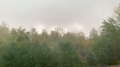
A classic example of what I call a SLC, my technical
meteorological term for "Scary Looking Cloud."
Looks like a tornado behind that hill, but it's just
scud clouds rising into a thunderstorm looking
east from Charlotte, Vermont early Tuesday evening
The thunderstorms broke the record heat
in Vermont toward the end of the dya. 
Tuesday was another day of absolutely bonkers record highs in the Northeast, including here in Vermont

 Plus, at the end of the day, Vermont was rattled by thunderstorms, which at least tempered the heat. . 

Despite the humidity you might still feel this morning, it's going to get a lot better, and very soon. 

But we'll have to watch for more interesting weather coming up in Vermont over the next few days.

There's lots to get into within this mornings post, so settle in!    

HEAT RECORDS SHATTERED

The wildest records were set from central New England on south.

Preliminary data indicates that Massachusetts broke the record for the entire state for the hottest June temperature ever observed - 103 degrees in Barre Falls.

Also, Connecticut reportedly broke its statewide record high for June with 103 degrees in Natchaug. Rhode Island broke its statewide record with 102 degrees. Maine (100 degrees) and New Hampshire, (102 degrees) tied their statewide June record high. 

Lebanon, New Hampshire, just across the Connecticut River from White River Junction, Vermont set their all time record high of 100 degrees. Lebanon's previous record hottest-ever day didn't last long, considering it was set on Monday.  

 I suspect once final reports come in, we'll find a few places in southeastern Vermont reached 100 degrees. That would be the second June in a row that a weather station in the Green Mountain State reached 100 degrees. Which is insane. 

Further south, several cities set new records for hottest temperature for the entire month of June. Among them were Boston, with 102 degrees; Providence, Rhode Island at 100 degrees;  Newark, New Jersey, 103 degrees; and Manchester, New Hampshire, 102 degrees 

A weak boundary ahead of a cold front prevented far northern areas of Vermont from getting even hotter than Monday. (I noticed rapidly rising temperatures abruptly leveled off somewhat near and north Route 2 in the early afternoon with a wind shift from south to west).

Still before some late afternoon and evening scattered thunderstorms arrived, record highs were set in Vermont and neighboring New York. This after a slew of record highs on Monday. 

Plattsburgh, New York hit 99 degrees, a record high and just barely missing out on two days in a row at or above 100 degrees.

Burlington on Tuesday was "colder" than Monday with a record high of "only" 97 degrees. That beat the old record of 93 set in 2003. 

Other Vermont record highs including 93 in Montpelier, exceeding the old 1995 record by four degrees. St. Johnsbury roasted at 96 degrees for a new record high. I noticed Springfield, Vermont reached 98 degrees.  

STORMS

Occasionally strong thunderstorms developed late Tuesday afternoon and evening in central and northern Vermont and New York as a cold front approached. Atmospheric conditions weren't all there for most strong storms to last long, but some managed to hold together. 

One storm formed near Burlington, Vermont and held together pretty intensely all the way down Interstate 89 to Barre, then on through eastern Vermont into New Hampshire, 

This thing produced a string was severe thunderstorm warnings along its path. Not many reports of damage came in, mostly I think because people were more focused on the heat.  However. Route 14 between Brookfield and East Randolph was reportedly blocked for awhile Tuesday evening due to numerous fallen trees. 

HEAT ENDS TODAY  

Early morning risers today would be forgiven for scoffing if I told the the record heat wave in Vermont is over. It was still really humid statewide early today, which would suggest another hot day.

What happened to the cold front?

It came through, but the cool, dry air lagged behind it a bit. But that much better air will gush in during the day today. You'll notice the humidity levels falling through the morning and afternoon. The air will feel much fresher, especially in the north by this afternoon.

Up in northern and central Vermont, where dew points were at uncomfortable levels near 70 degrees early this morning, will be in the refreshing 50s by this afternoon. High temperatures in the north will only be near 80 this afternoon. 

It'll take a little longer to flush out the hot, humid air in southern Vermont, especially in the lower Connecticut River Valley. High there could touch 90 degrees. Residents down there might not notice the lower humidity until later this afternoon.

MORE TROUBLE AHEAD?

The cold front that is cooling us off won't get all that far to our south, and will start moving north again as a warm front over the weekend.

At first, temperatures around here will actually be below normal for a change tomorrow and especially Friday. Some towns on Friday might not get out of the upper 60s, meaning highs Friday in a few places could be cooler than low temperatures were on Tuesday. . 

There could be some trouble with this in northern Vermont later Friday and Saturday. Some forecasts indicate a disturbance riding west to east along the front could unleash some heavy rains - perhaps enough to cause some flash flooding.

If that happens, it's most likely north of Route 2. However, this forecast is pretty uncertain. The heavy rain might set in southern Quebec instead. A few models put the heavier rain in southern Vermont.

Or perhaps the torrent won't really materialize at all. For now, NOAA's Weather Prediction Center has put far northern Vermont and northeast New York in a slight risk zone for flash flooding later Friday into Saturday.  

It looks like the heat might briefly return next Monday and perhaps Tuesday, but it won't be as bad as it was this week. I doubt we'll see more records broken. But it could get up to 90 degrees again next Monday. 


Friday, October 20, 2023

Another Weekend Big Soaker Coming To Vermont/New England Stick Season To Arrive

Still some decent fall colors yesterday in the Champlain
Valley, as seen in this shot in St. Albans, but this 
weekend's storm will mostly introduce 
us to stick season. 
 Early this month, we had a real soaker of a rain storm. The western half of Vermont in particular got it, with two to in some places more than four inches of rain.  

We have that soaker's kid sister coming up this weekend. Though rainfall won't be quite as much as the earlier storm, the 1.5 to three inches of rain in the forecast between now and Sunday night is pretty impressive.

The bad news is the long duration storm means the weekend will pretty much be a washout. It will rain most of the time, and turn chillier, and windier by Sunday. 

The good news is because it will take a couple days for that rain to accumulate, much of the water will soak into the ground, and the chances of flooding are pretty low. 

This will be a foliage season ender.  It's already way past peak in northern and central Vermont. As of yesterday, there was still some nice late season color in the Champlain Valley and warmer valley floors of southern Vermont. 

But the persistent rain and wind will pretty much introduce us to stick season. After this weekend, there will only be pockets of autumn color left. 

This is also how there could be some localized flood risks. All those fallen leaves get swept down small brooks and streams.  Then they all get stuck on an obstruction, like branches or a culvert. These packs of leaves can become really effective dams, backing up water. Sometimes, they'll let go, causing a bit of a flash flood downstream that can damage driveways and culverts and such.  

If you see leaves forming these dams and threatening culverts, try to break them up if you can do so safely. 

It's a one-two punch, with an initial disturbance coming from the south and a  wet cold front coming in from the west. That will set off today's showers, moving south to north across Vermont today.  The heavier rain today will be in southern Vermont, with lighter, more scattered stuff further north. 

Then a new, secondary coastal storm will get going and become the dominant storm Saturday into Sunday. This one will soak New England, including all of Vermont. 

The bulk of the rain will come down on Saturday. Through Saturday, it will remain mild-ish, but it won't feel that way with all the rain and the damp breezes. After highs in the 60s for most of us today, lows will only go into the 50s tonight, and stay in the upper 50s Saturday. 

The National Weather Service in South Burlington is
predicting more than two inches of rain (orange shading)
in much of Vermont between now and Sunday evening. 
As the storm heads off into Canada Sunday, the rain will become lighter and eventually more showery. But it still looks like a nasty day.  A good day to stay inside and watch NFL football, I guess. 

 It won't be that cold for this time of year, with highs near 50 or just above that.  Such temperatures are only slightly on the cool side for this time of year. 

But those cold rain showers and north winds gusting to more than 20 mph, it will feel rather miserable out there. 

If there's any snow, it will be limited to near the summits of the Adirondacks and Green and White Mountains. It also won't amount to much, so don't get your skis or snowboards out just yet. 

Monday still looks brighter, breezy and chilly, with highs only in the upper 40s to near 50.  Monday night, some areas of Vermont will see their first frost and freeze of the season, which is incredibly late.

Some areas, especially in the Champlain Valley might manage to stay above freezing Monday night and Tuesday morning, which will prolong this weird frost-free season longer.


Friday, August 18, 2023

One More Round Of Storm/Flood Threats In Vermont Before "Fair Weather" Takes Hold

As we approach the end of summer, forests begin to 
look tired. And you see splashes of fall color
from trees that aren't particularly healthy. 
 We've entered into what I call the tired phase of a Vermont summer. 

It still gets humid, but most of the time, anyway, we stop seeing the kind of heat waves we get earlier in the summer. Those towering clouds that produce thunderstorms often don't seem as enthusiastic as the big billowing updrafts of July and August. 

Forests and gardens look like they've had enough too.  A few sugar maples that aren't in good shape are already starting to show fall colors. The green on some of the hillsides looks a little faded. Look closely, and some of the leaves look a little crinkled and gray around the edges.

Chances are, your garden looks weary, too. Those perky ever so neat rows of new plants in May and June are now look like an unmade bed after a night of, ahem, activity. You've already scoured through them harvesting, and you probably have partly given up on weeding. It shows. It's near the end of summer after all.

Perennial beds are a mess, too. They're still pretty, but they also feature spent day lilies, gnarly hollyhocks, the fades mess of long-wilted spring flowers and those weeds. 

Of course, Vermont's summer of 2023 is kind of one to forget. We know all about the repeated storm and flood threats, a few of which didn't cause problems, but most did. 

True to form as this tired summer drags on, we have another threat today. Not a big one by this year's standards, but one to watch anyway. Then we get into the next phase of our waning summer, "fair weather." More on that in a bit. 

TODAY

Part of the problem is that the ground remains amazingly wet. For the most part, the last wet day we had, Wednesday, shouldn't have been that big a deal.   Generally a half inch to an inch fell, with some spot amounts at or a little above 1.5 inches. 

That normally would not cause much of a reaction at all. But its so wet that even that paltry amount, spread over an entire day, got brooks and streams running fast. Eventually, even the main stem rivers were running high. Not flooding, but high. I noticed surf was really up on the Winooski River Thursday morning. 

Some light showers Thursday evening ahead of
this morning's drenchers triggered this rainbow
over St. Albans, Vermont. 

 A band of rain, some of it heavy, was plodding eastward through Vermont this morning. 

Since it's been so wet, there could be just enough of a downpour in one or two spots to create some local flash flooding issues. If that happens, it won't be widespread at all, and won't last long. Still, it's best to keep an eye out. 

Even though this morning's storms mostly aren't severe, there's enough spin in the atmosphere that there's still a very low, but not zero chance that some storms could spin up a brief tornado, generally south of Route 2.

However, as I looked at radar images the morning, the strongest storms were down in Connecticut, heading toward Rhode Island and southeastern Massachusetts. I think there's a bit of a better risk of high winds or a quick spin up down that way. 

More scattered showers and storms will fire up this afternoon. We'll also have to watch those in case there's one or two instances of damaging winds or high water. However, the risk of all that is low.  Be weather aware, but this falls well short of panic mode. 

WEEKEND

Saturday will be the first in what will amount to several fall preview days. The storm system causing today's weather will be to our north. We'll have cool northwest breezes, plenty of clouds, especially over the mountains, and scattered light showers.

Those showers should be most persistent in the mountains and close to the Canadian border. They might last into the night. 

Sunday still looks nice, with clearing skies leading to at least a partly sunny comfortably warm afternoon. 

"FAIR WEATHER"

The weather pattern across the United States is amplified. That means that, at least for this time of year, there's lots of big dips and bulges in the path of the jet stream overhead.

A big dip in the jet stream is steering Hurricane Hilary toward California, as I mentioned Thursday. 

Meanwhile, there's a big northward bulge over the middle of the nation That's  heat ridge, and I expect a fair number of record highs over the next week or so over much of the Plains and Midwest.

On the front side of that ridge, the air will be blasting southeastward toward another dip in the jet stream off the New England coast.

 This will create very traditional "fair weather" in Vermont.  That's the kind of hybrid summer/autumn weather you often get in the Green Mountain State in the final days of August in early September. It's the time of year when county and state fairs are making the rounds. 

Afternoons are warm enough, usually in the 70s, so it still feels like summer as you stroll down the fair Midway.  But as the sun sets, you'll need a jacket or sweater to ward off the evening chill during the Grandstand Show. 

As the climate has changed, "fair weather" in Vermont has seemed to shift into mid-September, when most of the fairs are actually over. But this year appears to be a throwback into tradition.  So it's a little nostalgic really.  

And since "fair weather" features no extremes, that will be a nice break from the kind of summer we've had, too. 

Saturday, July 22, 2023

More Scattered Vermont Flooding Friday; Beautiful Sky Heralds End To Rain Nightmare

After flash flooding caused damage in Enosburgh Falls,
Vermont Friday, this peaceful scene greeted 
residents as the storms departed. 
 As expected, locally torrential rains triggered renewed flooding in a few spots in Vermont Friday, but that's pretty much over, and I think we can start breathing a sigh of relief.  

Most of Friday's trouble was in northwestern Vermont, which had been mostly spared all the flood grief we've been through for the past two weeks. 

Flooding was concentrated in and around Enosburgh Falls and Richford. Two sections of Route 105 were temporarily closed. One was in the Richford and East Richford area. The other was near the Dairy Center just north of Enosburgh Falls. 

Route 108 just above the dam in Enosburgh Falls was also closed for a time The basement of the Enosburgh Falls Village Offices was flooded and being pumped out Friday evening. 

Other flash flood warnings went up in parts of Addison and Rutland counties, and I'm sure there were a few washouts here and there win that neck of the woods.  So far though, no reports of super serious damage. 

Perhaps as a sign from the heavens that the two week old flood siege in Vermont might be ending, the sky over the Enosburgh area turned spectacular after the flood. As black clouds rumbled with thunder to the northeast, brilliant sun cutting in from the west lit up the trees and farm fields in bright electric green.

Brilliant rainbows lit up near the mountains. 

Indeed, for a welcome change, there are very few signs of trouble in the Vermont weather forecast. 

WHAT'S AHEAD

Today will be delightfully cool, with many of us not even making it out of the 70s.  There will be some sunshine, but also the risk of showers

For once, there's no need to freak out over those chances of rain. For most of us, any showers will be light and brief. The "hardest hit" towns today might see a quick downpour that could drop almost a quarter inch of rain - far too little to set off any new flood worries. So we're good. 

Patches of fog glow in the sun on hillsides near Enosburgh
Falls, Vermont Friday after a flooding thunderstorm
departed the area. 

Tonight will be probably be the coldest night for many of us since the third week in June. Almost everybody will get below 60 degrees. It will be a wonderful sleeping night. 

No complaints about Sunday. Expect sunshine and temperatures in the low 80s with manageable humidity. Perfect! 

The only trouble spot I see on the weather horizon is Tuesday. But I'm not too worried. We have a pretty typical mid-summer weak cold front coming in, which will probably set off a few showers and storms. 

I suppose there might be an isolated wind or water problem with Tuesday's weather, but it shouldn't be nearly as worrisome as all the recent storms we had.

It'll be on the warm side all week, with temperatures possibly reaching the upper 80s for the second half of the week.  

Long range forecasts are hinting at - but not guaranteeing - some actual cooler than normal temperatures as we open the month of August. If that happens, we'll be an exception. Most of the rest of the United States will continue baking in hot - sometimes dangerous hot weather 

Thursday, June 1, 2023

Record Vermont Heat Today Then A Long Chilly Period. Some Of Us To Get Needed Soaking?

Despite very warm, very dry weather, irises in my
garden seemed to dance in the sun Wednesday.
 Some changes have come into the Vermont weather forecast for this weekend and beyond. If those changes come to fruition, some (but probably not all) of us will get a needed soaking. 

First we have to get through today. The forecast is the same as it has been for today, hot and arid, with record high temperatures. 

Don't be fool by the relatively cool air this morning. This dry air heats up fast in the sun, and given that the atmosphere is primed for heat, the records should shatter this afternoon. 

Burlington is going with an expected high today of 94 degrees, which would break the old record of 90 set in 2011 and 2013.  I'm not sure, but I think that 94 sounds a little too bullish. Even so, I'm sure we'll get past 90 in Burlington. And that 94 is NOT out of the question. 

Today's record high for the date in Montpelier is 88 degrees and in St. Johnsbury, it's 91.  Those record highs definitely have a risk of being broken today.  

If you like heat, today and most of tomorrow are your last shot at it for awhile. Also, some changes in the forecast mean the hot spell might end with some decent rains - in some areas at least.

THE COLD FRONT

Earlier in the week, the cold front expected to come through later Friday looked like it would be another moisture-starved system, with just paltry, scattered rains with it. 

Now, at least from the Green Mountains eastward, the front looks like it might pack a fairly wet punch, which is good news. 

More moisture than previously expected will pool ahead of this front Friday, which will turn the day uncomfortably warm and humid.

Showers and thunderstorms will break out in the afternoon.  It doesn't look like any of the storms will be severe, but some of them will have decent downpours with them.  Meanwhile, an upper level low looks like it will dive southward with the cold front.

This will promote a lot of lift in the atmosphere from the Green Mountains east through the Connecticut Valley and on into parched New Hampshire and Maine.  Nearly an inch of rain or more, even, could come down Friday night east of the Greens, and probably in the southern third of Vermont.

At this point northwestern Vermont, roughly along a line from Middlebury to Jay Peak, will miss out of the needed rain unfortunately. Those areas will get some rain,  but it will only be less than a half inch. Possibly a quarter inch or a little less in some spots. So a little rain, but not the soaking we'll need.

There's always a chance the bullseye for the heaviest rain could shift westward a little bit, so that's something to at least wish for 

CHILLY AND MAYBE WET

We know it will actually be on the chilly side for this time of year, starting abruptly on Saturday, and probably continuing through next week. 

Given the heat we'll have for the next couple of days, the chill will seem like a shock to the system. Highs Saturday will only be in the 60s west and maybe just upper 50s east. Some rain will continue mostly in the southeastern half of the state on Saturday, but it won't amount to much.

It stays cooler than average for the season all of next week, but the wild card is rain chances.

We'll still need a soaking, especially northwest, but we don't know if that's in the cards.  Some computer models suggest just light showers off and on through the week.  Some others pull a lot of Atlantic moisture in from an offshore storm system and swing it over us with a soaker. 

The best chances of that happening are unfortunately in eastern, not northwestern Vermont. But these are pretty long range forecasts, and can change. 

Monday, April 17, 2023

April Heat Wave Finally Ending; We Might See Highs Like That Again Until Summer

It was hot again in northwest Vermont for one last day on 
Sunday. Also a bit more humid than on previous days,
so we saw a few of those billowy cumulus clouds
that are common in mid-summer, but less so now 
 It felt like a balmy summer morning in Vermont this Monday as the lingering effects of our record April heat wave remained. 

If you missed the warm weather this morning, you're (mostly) out of luck for probably the next several weeks. 

The heat over-performed in northwestern Vermont again on Sunday. Temperatures reached 83 degrees in Burlington. 

That wasn't quite a record high, but still a full 27 degrees above normal. Sunday's high and low temperature, combined with somewhat higher humidity than previous days, made it a perfectly average day - for mid-July. 

There were even those puffy, sort of towering cumulus clouds that are most common in mid-summer. I saw a couple isolate small air mass thunderstorms tower up in the Adirondacks, too.  You can get thunderstorms in April every once in awhile, but these partly heat generated ones are something for this early in the season. 

The cooling will start today as rain moves in.  High temperatures for the day will be this morning, with mostly of us getting into the 60s.  Which won't be hard to do since many of us were already there at dawn.

Temperatures will probably drift downward into the 50s this afternoon.   A cold front this evening will ensure we  go down further. 

By tomorrow and Wednesday, highs will only be in the 45 to 50 degree range. That's somewhat colder than normal for this time of year. It will feel like yet another shock to the system. Northwest winds will make it feel even colder.

Mountain tops will even get a little snow. That's not at all odd for mid-April, but it's definitely a change in the weather, 

We need rain after that weird hot spell, but I'm not impressed with the amounts forecast. Northwestern Vermont looks like they might get between a half inch and two thirds of an inch. The rest of the state seems destined to see a half inch or less.

The rain will dampen the tree pollen, which has been sky high in recent days, as anyone with allergies knows. Everything started bursting forth with flowers and buds and leaves all at once. The allergen onslaught was impressive. 

The hottest temperature - at least in Burlington - during this bizarre heat wave was 88 degrees. We might not see temperature that warm until June or July.  

The weather patter has shifted to one that will mostly keep us chilly for the next couple of weeks at least. We might one last brief, quick squirt of warm air Friday, but that might be it for awhile.  

Sunday, April 16, 2023

Extreme April Heat In Vermont/New England Might Lead to Crop/Garden/Forest Damage

Earlier than ever. Green leaves were starting to make an
appearance behind my St. Albans, Vermont house this
morning while a lilac bush in the foreground leafs
out and gets ready to bloom. Record heat this past
week as pushed spring into the too-soon category.
When I got up this Sunday morning, some of the early growing trees behind the house shimmered with tender new green leaves. The lilac bushes were brimming with tiny floret buds, ready to put on a show. 

I've never seen that kind of thing happen so early in Vermont.  It's truly remarkable.

This spring had been proceeding at a fairly average, comfortable, pedestrian pace, until the unprecedented early season heat arrived this week. 

Western Vermont won the heat prize Saturday. In Burlington, the record high Saturday was 85 degrees, breaking the old record of 82 set in 2003,

Everything springtime related leapt ahead far ahead of schedule. Things are where they should be around the first of May.  This race through spring will continue today with temperatures that will be far, far above normal again today. 

The summer party ends tomorrow with sharply cooler air.  Long range forecasts are suggesting that the second half of April might actually be chillier than normal.

If this cooler air is just kind of chilly without hard nighttime freezes, that will be good. It will just slow down the progress of spring and start to bring us more in line with where we should be.

Light to moderate freezes, temperatures that stay at or above, say, 28 in the Champlain Valley and in the mid 20s or better in much of the rest of northern Vermont between now and early May probably wouldn't cause much damage. Unless these readings are accompanied a lot of wind. 

 But it can get as low as the teens this time of year in most of the Green Mountain State that would be a disaster.

This coming week won't be a disaster, despite a particular chill in the air Tuesday and Wednesday. At least we'll get a little rain out of this shift to colder weather.  We need it. 

There's a good chance we'll have  widespread frosts and freezes Wednesday night, but I really doubt it will get cold enough to cause any real harm. 

This budding lilac floret, pictured here on April 22, 2021,
froze to death and never bloomed after a late season
snow and freeze that year. This highlights the danger of
what could happen if spring growth comes too soon.

However, if you brought your tender planters outside to enjoy the warmth, you'll need to bring them back indoors this week. 

My hibiscus has enjoyed the warm sun this week, for instance, but I'm locking it in the house and turning up the heat a bit when it gets cold starting this week. 

In the short term, we're safe, but I don't know how cold it might get in late April. 

These strange spring heat waves have already led to sometimes disheartening, or even costly damage.

A record early heat wave in Vermont back in 2002 brought the earliest 90 degree reading on record to Vermont on April 17 the year. Leaves on trees started coming out almost as soon as they are this year. 

Late in the month, hard freeze destroyed garden plants, and blackened swaths of forest by killing the early leaves. The visible damage lasted well into June before new leaves grew.  Trees being forced to re-leaf stresses them, in much the same way that spongy caterpillars did in Vermont last year and the year before,

Trees can usually withstand on year of defoliation, but if it happens year after year, it takes a toll. 

Other times, the damage from weird early heat is not so costly, but just a little depressing. 

Early spring, 2021 was warm and things were blooming early.  On April 21 that year, lilac trees were already displaying budding florets, and crabapple trees were just starting to bloom. 

Then a snowstorm and harsh freeze hit northwestern Vermont.  Some of the crabapple trees never really bloomed that year as a result. Many of the lilacs ended up stunted, only partially blooming.  Living without the annual spring display of full-blown lilacs was surprisingly depressing. 

Climate change has brought too-early heat waves that encourage too-early spring growth frequently in recent years. Sometimes, in the eastern United States, this has brought widespread agricultural damage, as the Southeastern U.S. saw in 2012 and 2017 and to a lesser extent earlier this year. 

That's not to say freezes are guaranteed to ruin our Vermont spring this year. The fact that it has come too early, though, leaves us prone to trouble. The best bet is just to hope for normal late April weather once this heat wave finally dies after today. 

Monday, November 7, 2022

Sunday Really Was Record Shattering, And The Strangest November Weather Day

On a strange, record breaking weather day Sunday, I 
spotted this cloud formation in a line of storms over
Lake Champlain. Looks like a funnel cloud, but I couldn't
discern whether is was spinning.
Could be scud, a rain shaft, or just a weird cloud. 
Well, that was strange. Really strange.

Sunday in Vermont brought record-shattering warmth, strong winds and some heavy convective downpours that just don't happen this time of year at all. Until they did Sunday. It was definitely among the most bizarre weather days I've experienced in my 60 years in Vermont. 

RECORD HIGHS

First, lets go through just some of the many high temperature records that were set.

Sunday was by a wide margin the hottest November day on record in Burlington. Which is saying something, since records go all the back to 1884.

The high temperature was 76 degrees, setting a new all-time record high for the month of November. The old record was 75 degrees on November 2, 1950 and November 6, 1948.

The low temperature in Burlington Sunday was 62 degrees.  That's the highest minimum temperature for any date in November. The old record was 60 degrees on two recent dates: November 11, 2020 and November 5, 2022 (yes, on Saturday).

A low temperature of 62 degrees is exactly normal for the height of summer in mid-July. 

Breaking monthly all time high temperatures seems to be a trend in Burlington.  There's 138 years of data, But just in the last 27 years of data, since 1995, nine of the 12 months have seen their all time high temperatures broken or tied.  

The last time a monthly low temperature was tied was when it hit 33 degrees in June, 1986. re were no all time low monthly temperatures set during that period.  

So, onto other Vermont records set Sunday.  Montpelier broke its record high for the date with 74 degrees, and set the record for the entire month for its highest minimum temperature which was 62 degrees. 

Extreme warmth and humidity by November standards
fired up some unseasonably strong lines of downpours
in northwestern Vermont Sunday. Here's one of the 
storms approaching South Burlington. 

Same story in St. Johnsbury. A record high of 74 was set, and the low temperature of 65 degrees was the highest for the entire month of November. 

The hot weather wasn't just limited to Vermont, of course. Many records, several for the entire month of November were set in the Northeast and adjacent southeastern Canada.

More than two dozen cities from Maine to North Carolina saw record highs both Saturday and Sunday.

Fredericton, New Brunswick reached 76 degrees for a new November record. Halifax, Nova Scotia reached 71 degrees, breaking the record high for the month of November which had just been set a day earlier. Montreal reached 74 for a new November record there, as well. 

STRANGE STORMS

I don't know whether they keep records on dew points, but Sunday was also probably the most humid November day on record.  The dew point is a measure of how humid the air feels, especially in the summer. That dew point got as high as 63 degrees in Burlington, which would have made it a moderately humid day in July.

With all that moisture in the air and an approaching cold front, bands of convective showers (essentially thunderstorms that had little or no lightning) repeated passed through northwestern Vermont in the afternoon and evening. 

This type of summer thunderstorm type set up is extremely rare for November. Especially Sunday's conditions, where several lines of storms formed. I counted five downpours in St. Albans, for a rainfall total of 2.1 inches, which is incredibly impressive. 

Milton reported 2.14 inches of rain. Georgia clocked in with 1.89 inches. 

The fact that the rain came in short, intense bursts was especially remarkable for this time of year. Rainfall rates in St. Albans were more than a half inch per hour. Luckily, each downpour was pretty brief, so we didn't get into any flooding.  

Along the southern edge of the deepest storms, Burlington managed 0.72 inches. All this is much more rain than was expected. But then again, it's hard to predict November weather when the temperatures are so far off the rails. 

Yet another line of downpours gathering steam Sunday evening
on approach to St. Albans, Vermont. Rainfall totals here
in Franklin County were as high as two inches 

Sunday's storms didn't qualify as severe, but they were strong.  Some had gusts to 40 mph or so, along with those torrential downpours.  It was hard to tell, but I also spotted what might have been a brief funnel cloud over Lake Champlain west of Burlington. It had the look of one, but the overall storm was not severe. One of life's mysteries, I guess. 

 The storms tended to fizzle as they encountered somewhat drier, more stable air along and east of the Green Mountains. Many places in the southeastern two thirds of Vermont had less than a tenth of an inch of rain. 

COOLER WEATHER STILL DUE

I think it's safe to say it won't be 76 degrees again until next spring.  Today will still be pretty nice for November, with lots of unseasonable sun and temperatures at least in the low 60s.  But those readings will tend to fall this afternoon.

Forecasters are still expecting a shock to the system type day on Tuesday with highs only in the 40s. Again, that's not far from normal, but normal feels weird after this past weekend.

We'll see another dramatic warmup late this week, but it won't be as torrid as it was this weekend. Still, the expected highs in the low 60s are fairly impressive for November. 

A pattern changing storm late in the week and early next week might pull up some moisture from Subtropical Storm Nicole, so we could see some heavy-ish rain toward Friday and early Saturday.

Then November arrives for real. Starting Sunday, we'll have a long period of near normal to colder than normal temperatures, possibly lasting most of the month.  

Despite the incredibly hot start to November, 2022,, there's a chance that the month overall could end up slightly cooler than normal. That is if the last half of the month turns out to be as cool as some forecasts indicate. 


Wednesday, June 8, 2022

Intense Heat Sets Up In The South; We In Vermont To Stay Comfortable

Peonies and irises in my St. Albans, Vermont gardens got
another drink of water from overnight thundershowers.
More rain is in the forecast, and hot weather will be
kept out of the region at least through mid-month. 
 A long spell of intense heat is beginning to build in the Southwest and south central parts of the nation, and record highs are beginning to fall.  

Up here in Vermont, a persistent dip in the jet stream will keep protecting us from the heat at least through mid-month. 

Triple digit temperatures extend this week from California to Texas. As the Washington Post's Capital Weather Gang summarizes, Death Valley could easily reach 120 degrees.  It's almost always hot in the Southwest this time of year, but this is up there, even for them.

Las Vegas could see record highs of around 108 or 109 degrees in the coming days. The forecast high for Phoenix on Friday is 113 degrees, which would edge out the record high for the date of 111 degrees.

What makes the heat especially dangerous is the overnight lows, or more accurately the lack thereof. Temperatures will stay above 80 degrees across this region at night. Most people have air conditioning, but a few do not. And some people are homeless. 

The lack of any nighttime breaks from the heat can cause heat related illnesses and deaths. 

The "heat dome" looks like it will eventually shift a bit eastward out of the Desert Southwest and then park itself over the southern Plains for an extended stay. 

That means the Southwest will go from record hot to just hot. But the southern Plains will bake day in and day out in near record heat. Recently, drought conditions in the southern Plains were beginning to get better because of frequent, heavy storms over the past couple of weeks.

But this heat dome will shut off the water in this region and once again, they'll dry out. The heat will probably spread into the Southeast as well, raising the prospect of triple digit temperatures from California to the Carolinas. 

The position of this "heat dome" which is basically just a broad, hot area of high pressure, will keep Vermont out of the heat. 

The jet stream, which generally drives weather systems, will head northeastward in the Rockies and up toward Canada, up and over the central U.S. heat dome, then head southeastward into the Great Lakes and Northeast.

That'll block the hot air in the middle of the nation from reaching us. Repeated cold fronts in that northwest flow over us will keep our temperatures more or less near normal at least into the third week of June.

There will be a few cool days and a few warm, humid-ish ones in there, but I'm not seeing anything extreme. 

With the flow from the northwest, it will be hard for any tropical air to make its way toward us, so these repeated cold fronts mostly won't have huge amounts of rain with them. But we'll have chances of rain pretty much every other day if this pattern holds, keep precipitation near normal.

In the short term, tomorrow looks like the wettest and chilliest day for the foreseeable future as a nor'easter of sorts passes through New England. A June version of a nor'easter is a weaker system than what you see in the winter.  So it'll just be rainy and damp.

After that, we fall into that pattern of average weather. 

One caveat: On the periphery of these heat domes something known as a "ring of fire" sets up.  That ring of fire is frequent, sometimes severe storms on the northwestern, northern and northeastern edges of the heat dome. 

During this spell of weather, it's possible that a cold front could time itself correctly, and have the correct atmospherics, to give us a threat of severe thunderstorms.

So far, there's nothing to suggest we'll see anything like that at least through early next week, and likel beyond. 


Sunday, October 17, 2021

Storm Summary And Fall Has Finally Arrived In Vermont

Screen shot of trees near my house in St. Albans, Vermont
being tossed by estimated wind gusts of 50 mph as
a damaging squall line roared through Saturday afternoon.
 Yesterday's line of rough storms in Vermont caused their share of damage as expected, but it could have been worse. 

Tree and power line damage was reported across many scattered locations in eastern New York and western Vermont.

For what it's worth, I took a video of the storm as it passed through St. Albans with gusts estimated of at least 50 mph.

Just up the hill from my house, the storm dropped a tree on a car and some power lines, and apparently started a house fire.

Video is at the bottom of this post.  It won't show up automatically if you're reading this on a phone, so click on this hyperlink to view.

On to the storm analysis!

 In advance of the storm, it had looked like some brief spin up tornadoes could possibly form in the Champlain Valley.

It turns out there were just two intriguing spots that could have produced a spin up, one in New York, one in Vermont. By far the most suspicious area was  a little southwest of Saranac Lake, New York.

There, radar seemed to indicate debris lofted into the air at one point. That's a pretty powerful signal of a potential tornado, but it's still not clear as to whether anything touched down there or not.   

One video taken in the area at the time shows what could be a funnel or tornado, perhaps.  Hard to tell because whatever was there was partly obscured by heavy rain. Some trees in that area were damaged, and part of a barn roof was torn off, according to WPTZ meteorologist Ben Frechette.

In Vermont, a radar scan briefly showed what is known as a "couplet" near Vergennes. That's where radar detects strong winds blowing in opposite directions in very close proximity aloft.  That could be a sign of an impending tornado. 

In this case, the couplet dissipated really quickly, and that makes me pretty sure nothing twisty touched down there.  

The straight line winds that raked the region with the squall line were certainly damaging, but they could have been worse, too.  Some of the worst winds were deflected just a few hundred feet above ground level.

 One radar scan clocked winds of up to 79 mph approaching Burlington just 200 feet above the surface. But down where people live, the highest gust at the National Weather Service office was just 44 mph, and a few places around Burlington surely gusted to about 50 to 55 mph. 

In most of northern Vermont north of Route 2, Saturday's storm for most people probably did more good than harm. 

The U.S. Drought Monitor still has areas along the Canadian border in moderate drought, and the area of Vermont considered "abnormally dry" expanded in the past couple of weeks to two thirds of the state, instead of the northern third the previous week.

Saturday's rain was a good soaker. Burlington reported 1.2 inches of rain, and my unofficial rain gauge in St. Albans, Vermont captured 1.45 inches. We need the rain. 

Going forward, I guess we can now finally declare that summer is over. The weather in Vermont could have passed for August in the past week. The well-advertised cooler air is now here, and that will only intensify tonight and tomorrow. 

As I've been saying right along, this colder air isn't at all unusual for October, but it is quite a change.  They're still expected some wet snow flakes at high elevations tonight through Tuesday.  Quite a few clouds and scattered light, chilly rain showers are a good bet, especially in northern Vermont into Tuesday. 

Nights will be too cloudy and breezy early this week to create any frost, so most of us will keep creeping closer to the record for the latest first autumn frost on record. 

We might or might not break those records. The next chance for a frost/freeze I see is probably next weekend. 

Here's the St. Albans storm videoClick on the arrow, then the YouTube logo to view it in full size: