Showing posts with label record heat. Show all posts

Thursday, August 27, 2026

As El Nino Builds, July Tied For World's Hottest On Record, August Running Super Hot, Too

The world tied the record for the hottest July, according
to NOAA. If anything, August might be even 
further above normal as El Nino takes hold
As I noted in a previous post, El Nino is building on climate change to bring the world's temperatures to new heights. 

While we're heading into the last days of August, we see the July data is fully available. 

Data released about a week ago indicated July, 2026 tied with 2024 as the hottest on record. This is according to NOAA's National Centers for Environmental Information.  Since July is normally the world's hottest month of the year, so 2026 and 2024 are the world's hottest month on record. 

The Julys of 2023, 2024 and 2026 were the only Julys that were 1 degree or more Celsius above the pre-industrial average. 

Climate change has been going on for quiet awhile now, it's just accelerating lately.  For instance, the last time the world had a July that was at least a little bit cooler than average was in 1971.  

Land areas in the Northern Hemisphere were easily the hottest on record, breaking the previous 2024 record by 0.12 degrees Celsius, or 0.22 degrees Fahrenheit. 

Hot Oceans

Even more ominously, global ocean temperatures reached a record high for July. About 70 percent of the world is covered by oceans. Heat is released into the atmosphere, where it causes mischief in the form of record heat, droughts, and unusually vicious storms.

Overall, on average, world ocean temperatures peak in the spring, then declines until June, then rise to a secondary peak in early August, then slowly begins to decline again, 

This year, the global average ocean temperature rose rapidly since July, reaching an all time record of 21.1 degrees C as of August 21.  This odd late season increase has almost everything to do with the burgeoning El Nino. But since ocean temperatures were already elevated by climate change, it was easy for the oceans breaking records. 

Relative to average, the warmest places were most of North America, Greenland and Iceland, western Europe, Central Africa, northwest Asia, parts of Russia and Siberia. 

As usual in this climate-changed world, there were few areas that were on the cold side, and most of the "cold" areas were just barely, compared to the 20th century averages. The cool areas were Alaska, the persistent cold blob in the Atlantic south of Iceland, parts of Antarctica, and, marginally, parts of northern and central Europe. 

UNITED STATES

The Lower 48 of the United States had its 
hottest month on record in July. All states
were warmer than average.
In the United States, we had the hottest month on record in the Lower 48. Not just hottest July, ,though the month is usually the hottest of the year.   

Every state in the Lower 48 was warmer than normal, which is an extreme rarity. Even when the Lower 48 has an overall warm month, a few states are at least a little cooler than normal. 

While everyplace was warm, the hottest relative to average were in the central and northern Rockies and in the northern Plains. 

When you add up all the states that were way warmer than normal and sort of warmer than normal, we end up with the hottest month on record for the Lower 48. 

Wyoming had its hottest July on record. Utah, Colorado, New Mexico and North Dakota had their second hottest July on record. A total of 18 states had one of their top ten warmest Julys on record. Vermont had its 31st hottest July on record. 

Overall, the Lower 48 was drier than normal. Typical of summer the wet areas and dry areas were pretest spotty and random. 

Despite the dry theme, there were intense local floods, including in the Texas Hill Country and in the Northeast. 

New England had some of the most extreme disparities in precipitation. Southern New England was wet, with Rhode Island seeing its sixth wettest July on record. By contrast, Maine had its fourth driest July on record. 

Vermont had its 47 driest July out of the past 132 years. 

Meanwhile, August around the world has been running super hot. It's widely expected to be the hottest on record. We'll have updates, of course, when complete data for August becomes available.  

Tuesday, June 30, 2026

Dangerous Heat, Humidity Blast Into Vermont Today For An Extended Stay, Severe Storm Threat Looms, Too.

Heat risk map for Thursday. Purple is extreme heat and dark 
red is major. It's rare to have so much purple in this
map, Note the flecks of purple here in Vermont. 
 We had one more nice, cool Vermont dawn today, with temperatures in the 50s as the sun broke over the Green Mountains. 

Yesterday was warm, for sure, but not humid, so the lack of moisture in the air let things col off overnight. 

Going through the next several days at least, you'll want to take it very easy, keep hydrated, and make sure your neighbors and relatives are OK. 

Let's get into the updated day by day outlook.

TODAY

The hot, humid air is at our doorstep, and will flood in today. The dew point, an indicator of how sticky the air feels, was in the comfortable 50s early this morning. Those dew points will be in the icky mid 60s to around 70 by late afternoon, and it will only get worse from there. 

Most of us will get into well into the 80s today with the hottest valleys maybe touching 90 degrees if it stays sunny enough. If it hits 90 in Burlington today, that would probably be the start of five consecutive days in the 90s. 

Heat waves that long or longer have only happened 16 times in Burlington since the late 1800s. 

The forecast for the increasing heat is certain, the forecast for thunderstorms is not. 

As we've noted the past few days, we'll be prone to batches of thunderstorms diving down from Ontario and Quebec. And since the air will be so hot and humid over the next few days, a few homegrown strong storms could pop up, too.

For now, as of early this morning, NOAA's Storm Prediction Center has most of Vermont under a slight risk, level two of five of severe storms today and tonight. They also have - once again - a low but not zero chance of a brief tornado, this time in northwest Vermont and northern New York 

This will get updated one way or another later this morning, as it's hard to predict the path and intensity of these packages of thunderstorms that will come through. Not only today and tonight, but through this heat wave. 

WEDNESDAY

The core of the heat wave arrives. Dawn will break muggy with temperatures in the upper 60s to low 70s. An extreme heat watch is in effect for the Champlain Valley, low elevations of southwest Vermont and the lower Connecticut valley Wednesday afternoon to Friday evening. That means the heat index is expected to be at or above 105 degrees during this spell. 

This will almost definitely be upgraded to an extreme heat warning soon. Such a heat warning only applies to heat indexes of 105 or above Since the rest of Vermont away from the hotter valleys will "only" see a heat index in the 100 to 105 degree range, they'll probably fall under a heat advisory soon. 

As far as actual temperatures, highs tomorrow should be in the low to mid 90s, with the hotter readings in the warmer valleys. Dew points will rise to the mid 70s, which is fairly rare for Vermont. The weather tomorrow and Thursday will be typical for a Florida July. Or even worse than that.

Orlando, Florida yesterday had a mid -afternoon temperature of 92 with a dew point of 74. Mid-afternoon tomorrow in Burlington is forecast to bring a temperature of 95 and a dew point of 75.

Burlington will very likely have one of its top ten worst heat indexes on record, and has a slight chance of breaking the all time heat index record of 111.4 set on August 26, 1948. The forecast peak heat index for Wednesday is 109, which would place it at #3 in the top 10 list of worst heat indexes the city has seen, at least since they started keeping track of such things in 1947.

The one potential saving grace is if thunderstorms bring the temperature down. Or, thunderstorms that had broken up send clouds our way, which would mean slightly lower temperatures but no relief from teak humidity. 

Again, it's impossible to predict the timing and position of the most concentrated thunderstorms tomorrow but they could happen anytime. Some storms could be strong again. With all this humidity, thunderstorm rains would be torrential perhaps enough to set off a highly localized flash flood,

THURSDAY/FRIDAY

More of the same with probably the most intense heat on Thursday. For now the National Weather Service is going for a high of 98 in Burlington and Springfield, and well into the 90s elsewhere. There is a chance we could see a 100 degree reading or two.

How about this for a break: Friday should be cooler than Thursday, with highs only in the low to mid 90s. And the steamy air will continue. 

Nighttime lows Wednesday through Friday will be in the low to mid 70s in most of state with the stuffy air in place, Those without air conditioning won't see any real nighttime relief. Keep a close eye on your  elderly or ill neighbors that don't have air conditioning. This is dangerous for them 

.The extreme humidity will continue both days. As will the chance of thunderstorms, some potentially strong and/or torrential. If the storms, or clouds from distant storms cover the sky in the afternoons, high temperatures will be a little cooler forecast. 

WEEKEND AND BEYOND

Often, heat waves in Vermont end with a big whoosh of dry, cool, refreshing air straight from the friendly folks in central or northern Canada. That won't the case this time. 

Instead, temperatures will slowly drift downwards, Highs would still be near 90 on Saturday and in the mid and upper 80s Sunday and Monday. Humidity will stay high, too, but not quite as terrible as this week will be, 

But since the effects of heat waves accumulates in people as the days go by, this allegedly "cooler" air won't be enough to help people who endured the heat without air conditioning, You'll still want to make sure your elderly friends and neighbors are OK.  


Friday, June 12, 2026

Near Record Highs, Strong Thunderstorms In Vermont Today

A large part of the eastern U.S., including
most of Vermont, is under a level 2
slight risk of severe thunderstorms today. 
Level 2 out of 5 risk levels is 
in the yellow shaded areas. 

Heat and storms is the story today, as our hot weather peaks and a what is technically considered a cold front lurks to our west today.
 

We got a preview yesterday as the heat over-performed in at least some places. 

The heat over-performed a bit on Thursday, Burlington reached 91 degrees. It was a little sunnier than expected during the afternoon, which helped raise the temperatures a bit. .

Burlington tied the record for lowest high for the date Thursday, with a muggy low of 71 degrees. 

Storms were also thankfully more lackluster than expected on Thursday. 

A few small storms popped up here and there, but didn't amount to much, just some local downpours in a handful of spots. Then we get into today, which should be dreadful 

TODAY

Stormy and hot and humid is the word. Definitely a busy day. Most of us should get through much of the day without storms. They should become a problem later in the day.

Heat

The low temperature -  if you can call it that - this morning was 73 degrees in Burlington. If that holds through midnight, which is iffy, we'll have another record high "low" temperature for the date. 

That sets the stage or record highs, which we have a good shot at  being tied or broken. 

 The expected high temperature in Burlington is 95 or 96 degrees. The record high for today is 94 set in 2017. In Montpelier, the expected high today is 93 04 94 or so.  The record high there today is 88 degrees.

St. Johnsbury probably won't break their record high, but they should get close.  The record high there is 94 degrees, and the forecast high is in the low 90s.  In southeast Vermont, in the lower Connecticut River Valley, highs today are expected to be in the 93 to 96 degree range. 

Needless to say, heat advisories are in effect for low elevations in western and southeast Vermont. Other parts of the state don't quite it the criteria for a heat advisory, but it will be close.  It will be a dangerous day for vigorous outdoor activity. Stay in the shade if you can, drink plenty of fluids,  and stay in the air conditioning if at all possible.  

Today would be a great day to "kidnap" your elderly neighbor, relative or friend who does not have air conditioning in their house. Take them to a cool movie, or a restaurant with drafty air conditioning. They'll need it. 

Storms

We started this morning with a few showers and downpours across eastern Vermont, but that's not the main show. 

Things should begin to fire up  this afternoon.  The heat and humidity puts us on a hair trigger for fast developing storms.  It doesn't take much to set off some instant potentially strong thunderstorms in this environment.  

However, the actual triggers for storms today are  somewhat lacking. You need strong winds aloft that change direction with elevation to really get a severe weather outbreak going. 

We're sort of missing  the strong upper winds. Also, the "cold front" is coming through basically in pieces later today and tonight, so there's no big change of air. And it's barely cooler behind the front. 

All that is working against severe weather. But not preventing it. 

The models still disagree as of this morning about how many storms will form, and how bad they'll be, ad how they'll behave.  Something called the HRRR (a rapid refresh model that's updated every hour) has a fair number of storms, some possibly severe entering western Vermont by mid-afternoon. Other models wait until early evening to bring on the storms.  

The American computer model seems to think today will turn into something of a yawner. I'm not buying the American model, really. (The American model doesn't provide as much detail as some of the others). Other models bring in some potential strong storms, but not as aggressively as the HRRR. Pick your poison. 

I think the end result is a few of us will end up blasted by strong to severe storms. Many of us will at least hear thunder and get some rain, maybe a downpour.  Some towns will get nothing at all. 

NOAA's Storm Prediction Center pretty much has nearly all of Vermont in a slight risk for severe storms. That's a level 2 out of 5 risk. It means scattered severe storms are a good bet. Far eastern Vermont as of early this morning was in a level 1 marginal risk of isolated severe storms. 

This risk zone might be updated or changed later this morning. The key is the upper level winds. If they're even more lame than forecast, the risk of bad storms goes down. .If those winds increase, so does the risk of wild storms. Stay tuned on that as well. 

As always, we don't know who gets the severe storms until right before it happens. Between the heat, humidity and the storm risk, jettison your hiking plans.  Making today more complicated, the lack of high winds aloft means a severe storm could develop in a snap, then choke itself off quickly, only to be replaced by another strong storm not all that far away. 

Have a way to receive severe storm warnings. And, to be Captain Obvious once again, if you see dark clouds and hear thunder, it's time to get off the water, off the beach, out of the garden and head indoors.

Any storms that do form could have really torrential downpours. That could lead to isolated instances of flash flooding. NOAA's Storm Prediction Center has placed us in a marginal risk zone for such floods. The vast majority of us will be fine, but again, you'll won't know where the damaging gullywashers will hit until they actually arrive.  

I'd say a storm could pop off anytime after about noon, but the best chances are from about 3 to 8 p.m. or so. 

WEEKEND

We're calling it a "cold front" coming through later Friday but that's pretty highfalutin way of describing the lame thing that's actually arriving. Sure, it will fire up some storms today, as mentioned. But when it's oppressively steamy out there, it doesn't take much to get storms going. 

The truth of the matter is it won't really be "colder" behind our cold front. The temperature will drop a few degrees, but it will stay awfully warm. It will be less humid, but not exactly bone-dry, either. 

Some details:

Saturday: 

Very warm and sunny, a perfect summer day in Vermont. Highs should get up into the mid and upper 80s, so it should be a nice beach or swimming hole day. A few puffy clouds might decorate the skies, making it all the more scenic . 

Sunday

Very warm to hot again. A few places in the lower Connecticut Valley and Champlain Valley could reach 90 degrees again. But a cold front will be approaching. A real one this time. It looks like the front will stir up a bunch of shower and thunderstorms again during the afternoon. We're waiting on more information, but for now, there's a chance of a few severe storms too. 

In fact, there might be a better chance of severe storms Sunday than we have today. We'll provide updates as we get closer to the event. 

EARLY WEEK

Behind the honest to goodness real cold front, it will, turn, obviously, cooler. But not cold. This won't really be weather whiplash. Instead, we'll see highs generally in the 70s for the first half of the week, maybe ticking up toward 80 degrees once we get toward Wednesday.   

A storm spinning up near Hudson Bay might swing a few light showers our way during the first half of the week, but it won't be anything to worry about. It'll be dry most of the time. 


Wednesday, April 29, 2026

March Was World 2nd Warmest, Possibly Signaling New Hot Push, U.S., As Expected Shattered March Heat Records

March, 2026 was tied for the second warmest on
record on Earth. With an El Nino coming,
the month's temperatures could be a signal
that unprecedented hot times could
be on their way.
 The global temperatures in March were back to their old tricks, going back to second hottest on record after several months of "cooler" months that were only in third place in the hottest months list.

Even hotter, more dangerous times might be ahead in the coming months or year or two. 

Actually this March barely squeaked into second place. It was virtually tied with March, 2024. The National Centers for Environmental Information continues: 

"All March global temperature departures ranking in the top 10 during the period 1850-2026 have occurred since 2015. This month marked the 50th consecutive March with a global temperature departure above the 20th century average."

The March, 2026 global temperatures might represent an ominous reversal in ever-so-slightly cooler trends we saw over the past year or so.  La Nina, which tends to cool the global climate, put a stop to a month after month stretch of almost continuous record global heat in 2023 and 2024.

Starting last June, most months were the third warmest on record. That's scary enough, since La Nina could barely put the most unnoticeable dent in the effects of climate change. The effects of La Nina might have peaked this past winter. December, January and February were all the world's fifth warmest, respectively. 

La Nina has faded and it loos like El Nino - which generally warms the global atmosphere - might be developing. It could be a strong one, and that could send the world's temperatures skyrocketing to new, dangerous heights by next year. 

The higher the global temperatures, the higher the risk of killer heat waves, worst droughts, increasingly torrential floods and more intense, less predictable storms. 

THE DETAILS

As always in this age of climate change, cold spots were hard to find in March.  However, there was a notable very cold area in Alaska and the Yukon Territory of Canada. That area was much colder relative to average than we usually see in these monthly reports. 

The only other slightly chilly areas I could find on the NCEI maps were small areas in northwest Africa, Antarctica, the extreme southeastern Pacific ocean and northwestern Siberia.  And what is now almost a perennial area of coolness hovered over an area of the North Atlantic a little south of Greenland. 

Also, although March as a whole in Australia wasn't cold, a sharp frigid snap at the end of the month shattered decades-old March temperature records in many cities, NCEI reports. Two Australian cities reported all-time record lows. 

The most wild hot spot relative to average was the contiguous United States. I'll have more on that below. Other really notable hot spots relative to average were in the entire Arctic (north of that Alaskan cold spot), northern and eastern Europe, large areas of Asia and spots across Africa and Antarctica.

Year to date, the first three months of 2026 is so far the fourth warmest year on record. It's almost certain this year will be among the top 10 warmest on record and likely among the top five. 

As is usually the case for March, Arctic sea ice extent reached its maximum extent of the year on the 15th. It wasn't that extensive. The ice covered 5.52 million square miles, statistically tied with last year for the smallest maximum in the 48 years satellite have been keeping track, according to the National Snow and Ice Data Center. 

UNITED STATES

The contiguous United States was exceptionally 
warm in March, breaking records from 
coast to coast. We'll see if it's a harbinger
 of a torrid summer. 
As we have been reporting, March, 2026 was ridiculously, insanely hot in the Lower 48. Now we have the final receipts.  

NCEI tells us: 

"The average temperature over the contiguous US (CONUS), in March was 50.85 degree F, 9.35 degrees F above average, ranking as the warmest March in the 132-year record. This marks the first time any month's average temperature has exceeded 9 degrees F above its 20th-century baseline. It also includes the warmest 12-month period on record for the CONUS (April, 2025-March 2026)"

Even more remarkably, the nations average high temperature during March was 64.4 degrees, an incredible 11.4 degrees above the 20th century average. That super warm March average daily maximum was actually 0.9 degrees warmer than the average April high. 

 Ten states had their warmest March on record. They were all large states in the southwestern United States, so those made up about a quarter on the United States. Included those ten, 35 states had one of their top 10 warmest Marches on record. 

Put another way, more than 500 counties, covering more than one quarter of the Lower 48 and affecting about 79 million people, recorded their warmest March on record, NCEI tell us. 

The "coldest" state was Maine, but even they were well above normal.  Maine had their 33rd warmest March out of the past 132 years. Vermont was one of a handful of other very warm but not super warm states. The Green Mountain State had its 19th warmest March. 

Mostly because of the continuing record high temperatures in the Southwest and Rockies all year so far, January-March is also the hottest on record. 

There was one particular cold spot in the United States: Alaska. The state had its fourth coldest March out the past 102 years. The last time Alaska had a March that cold was in 1972.

The heat, relative to average, diminished a little in the United States in April, so I'm guessing we'll get a break in the month after month reports of record warmth. 

The United States also had its eight driest March on record. In general, the states that were the warmest in March were also the driest. California had its driest March on record. Eight other states in the Southwest and Southeast had one of their top ten driest Marches.

The only really wet areas was around the eastern Great Lakes. Michigan had its third wettest March. Here in Vermont, March precipitation was right around average.  

It'll be an interesting to see whether March was a prelude to an extraordinarily hot summer, or just another month that really went off the rails. 

Monday, March 23, 2026

"Impossible" Extreme U.S. March Heat Made Possible By Climate Change

Map depicting where record highs were set last Friday.
Pink dots were where all-time high temperatures records
for March were broken. Climatologist are very hard
pressed to recall when, if ever, all time monthly
highs were established over such a large area. 
Climatologists are absolutely stunned. 

The temperature over the past few days in the western and central U.S have been beyond insanely high the past few days. Worried scientists say this would not have been possible without climate change. 

The heat has frightened millions of non-scientists in the West, too. . This could be a harbinger of never before imagine heat in the future. 

It's only March.! Read through the following reports of record heat and tell me if these temperatures  even seem possible this time of year. 

RECORD HIGHS OBLITERATED

On Thursday, the national record for hottest March day was broken when it reached 110 degrees not far from Yuma, Arizona. That beat the old national record by two degrees 

Then Friday not one but four weather stations not far from Yuma, Arizona reached 112 degrees, breaking the national record for hottest March day that was set the day before. 

The record was only one degree from the national record for hottest April day.  The old record was set the day before.

The 112 degree readings were on both sides of the Colorado River, so California and Arizona set new statewide records for hottest March day on record.  

A total of thirteen states from California to South Dakota had their hottest March day ever. To be clear, these aren't just individual cities, these are statewide records. 

Theses include places that are often wintry this time of year. Vermillion, South Dakota reached 97 degrees. Three locations in Wyoming got up to 90 degrees. Luverne, Minnesota was at 88 degrees.

After a record warm winter and now this March heat wave, a few spots in Montana, a few plants are showing signs of new leaves, - 30 days ahead of schedule. Parts of South Dakota and Wyoming are also running nearly a month ahead of schedule. 

Northern Mexico is also experiencing record March heat, too. Hermosillo, Mexico reached 108.5 degrees, setting a new national record for hottest March day. The old record was 105.6 degrees. 

Back in the United States, in higher elevation Flagstaff, in northern Arizona, the hottest ever March temperature there was 73 degrees, set on March 17, 2007. Then this month came along. Last Tuesday, Flagstaff tied that record. On Wednesday, it beat that record by three degrees. Then on Thursday, the temperature in Flagstaff reached 84 degrees. 

That broke the 2007 March record high by 11 degrees. It also broke the all time April record by four degrees. 

In the infrequent case in which a weather station breaks an all-time record for a given month, it seldom break the record by more than a degree or two. On very rare occasions, a new high might exceed the old mark by three or four degrees. But 11 degrees? And breaking the following, warmer month's record by four degrees?

Flagstaff wasn't the hottest place in this heat wave, but it was probably the scariest. 

PHOENIX

Meanwhile down in the desert in Phoenix, the record books were rewritten in a similarly frightening fashion. But it's dangerously hot there. 

Prior to this year, the hottest it had ever been during March in Phoenix was 100 degrees.

Daily highs on March 18 through yesterday were 102, 105, 105,105 and 102 degrees, all obviously record highs The next six days in Phoenix are all forecast to be somewhere between 98 and 102, and each would be record highs. That's 11 consecutive record highs, which is insane, a word I keep using. 

Phoenix seems to have entered a new era of extreme heat under climate change's spell. 

Eleven consecutive record highs are almost unheard of, but not quite. An American city had 21 consecutive days with record highs in September and October, 2024. That city was Phoenix, and that stretch set a record for most consecutive record highs in any U.S. city ever .

The all-time record highs for September and October were also set in 2024 .

All but one of the 10 hottest years in Phoenix have been since 2012, and the top five hottest have all been since 2014. The two hottest years in Phoenix were last year and the year before.  This year is off to a start that would break that record for hottest year once again. 

EFFECTS

World Weather Attribution has already examined the ongoing heat wave and has concluded it would have been virtually impossible without climate change. 

The winter was also record warm in the western half of the United States. This is the second consecutive month in which an all-time record high was established for an entire month for the entire nation. That new record was 106 degrees in Falcon Dam, Texas. 

The record warmth in the West resulted in a paltry snow pack in the mountains. Now, this heat wave is melting what little was left.This summer, water shortages could affect the 40 million people who rely on the Colorado River. 

Wildfires are already burning way ahead of the normal season in the western U.S. Unless there's a long and sustained change to a wetter weather pattern, the fire season in the summer of 2026 could also get very scary, very fast.

We here in Vermont are not participating in this particular, record smashing heat wave. Back in 2012, we were enveloped in another March heat wave that shattered records in the eastern two-thirds of the United States. More than 7,000 record highs were established in the U.S. during that mid-month spell.

Here in Vermont, Burlington had five consecutive daily record high temperatures, including an unprecedented three consecutive days that reached at least 80 degrees.

At the time, the March, 2012 heat wave was considered almost a once in a lifetime experience. We'd never see more widespread hotter March temperatures than that.

And here we are, easily outpacing 2012. 

It's an ominous sign for us and the rest of the world. 


Tuesday, March 17, 2026

Deep Snow, Unseasonable Freezes, Record Heat, Tornado Busts: March Weather Madness Reigns

A scene from the blizzard in northern
Michigan, via Facebook, Michigan
Storm Chasers
 The big storm that was harassing the United States is mostly gone, but its left damage, weird weather and the risk for more problems in its wake. 

BLIZZARD

The blizzard lived up to its promise, as forecasts for somewhere in the neighborhood of three feet of snow verified in the Upper Peninsula of Michigan and in Wisconsin. Harbor Springs, Wisconsin was buried beneath 40 inches of new snow. Cheboygan, Wisconsin saw 38 inches of snow, while Wausau picked up 30.9 inches. 

This all got whipped up into massive drifts as strong winds blew throughout the storm. 

Marquette Michigan picked up 36.3 inches of snow new snow. That makes this month's total there so far 54.4 inches. I think I'd kill myself instead of shoveling my driveway with that amount of snow!

Before the storm was even finished yesterday morning there was 47 inches of snow on the ground. They haven't had less than two feet of snow on the ground since January 4. Talk about never-ending winters!

Video showed vehicles stuck for miles in the snow on an Interstate highway near Green Bay, Wisconsin fPeople in those cars said they'd been stuck for five hours or more. Green Bay had its deepest single-day snowfall since at least 1889, with 17.1 inches on Sunday. The city's storm total came to 26.6 inches.

In Illinois, snow wasn't nearly as deep, but strong winds sent tractor trailers on icy Interstates spiraling into ditches. 

SEVERE WEATHER

The good news is that there were no major tornadoes anywhere on the East Coast yesterday. Ahead of the storm, the atmosphere seemed primed for strong tornadoes in the Mid-Atlantic states.

Thankfully, that isn't what happened.

Some thunderstorms formed early in the day near the North Carolina coast. That siphoned some of the heat and moisture needed to produce rotating supercells and tornadoes. There were a couple of tornado warnings in Maryland, but none touched down. A couple of weak tornadoes were reported in North Carolina. 

We did see 485 reports of wind damage, mostly involving fallen trees and power lines. And even better news: No severe thunderstorms or tornadoes are forecast anywhere in the U.S. during the next week. 

WILDFIRE

A final capture before a trail camera was destroyed in
the big Nebraska fires. The camera owner was able to
recover an SD card from the melted camera.
Strong winds to the south and west of the massive storm that blasted the Great Lakes region helped fan the largest wildfire in Nebraska history. 

Collectively, four fires in central and western Nebraska have burned around 750,000 acres. As of yesterday, there was 0% containment, though updates this morning indicated the fires were now partially contained. One person has died in the fires.

One of the four fires, the Morrill Fire, is the largest in the state's history. At last report, it had burned through nearly 573,000 acres. An update this morning indicated it was 18% contained. 

Most of Nebraska is in drought. Dry, windy weather. A red flag warning is up for Nebraska today, and a fire weather watch is in effect tomorrow, when it is expected to turn windier and even drier. 

Brush fires and wildfires have afflicted the Plains through the second half of winter and now into March. The region has been persistently dry and frequent wind storms have fanned the flames.  

FROSTY SOUTH 

Early season crops and gardens across the South are taking a serious beating from frost and freezing temperatures. The huge storm's strong north winds and an accompanying strong dip in the jet stream brought wintry air far south. 

Last week brought record breaking high temperatures to the South, and that really got plants going after a chilly winter with plenty of freezes. This morning's subfreezing temperatures were surely a big setback. 

Huntsville, Alabama went from 71 degrees just after midnight yesterday to a burst of snow just 10 hours later.

By this morning, several places in East Texas and Louisiana saw record lows . In Shreveport, it was 25 degrees, besting the old record of 27 degrees. Longview, Texas reached 27 degrees, breaking the record low by a degree. 

Birmingham, Alabama got down to at least 27 degrees, which breaks the record low for the date of 28 degrees.

Freeze warnings are up again for tonight from eastern Arkansas all the way to the Carolina coast. 

WESTERN HEAT BUILDS

As noted in a previous post, the Southwest is entering an unprecedented stretch of extremely weird March heat. 

Each day from tomorrow through Sunday in Phoenix will feature high temperatures between 102 and 107. Those highs each day will be at least seven degrees above the current record highs, which is absolutely bonkers. 

Highly unseasonable extreme heat warnings are going into effect in the Desert Southwest. This heat wave is more dangerous than most because people aren't climatized to the heat yet. Plus, the deserts are overrun with tourists who are there to enjoy what is normally a cooler time in the deserts. Plus, extra tourists were attracted to a super bloom of flowers in Death Valley and the Mohave Desert. 

Despite all these weirdnesses around the nation, the odd weather is settling down for now, with the glaring exception of the Southwestern heatwave.

i'm sure the atmosphere is just recharging for more fun and scary and gobsmacking weather times ahead.  

Wednesday, October 8, 2025

A Welcomed Drencher In Vermont After Record October Heat. But Drought Continues, And A Freeze Tomorrow Night, Too

Some pretty clouds early Tuesday morning over St.
Albans, Vermont were the first sign of some welcome
rain that hit Vermont overnight. Many places had
well over an inch of rain, but that won't be 
nearly enough to mitigate our serious drought. 
The weird Vermont October heat wave is decidedly over, drowned by a cold front that brought some extremely welcomed and locally heavy rain to the region. 

The heat did hang on for one more day on Tuesday before the rain moved in. 

I'm not aware of any more record highs in Vermont Tuesday, but several places got above 80 degrees. Burlington had its fourth consecutive 80+ reading before the clouds and rain arrived.

I had been reporting that four 80 degree days in a row would be a record long streak for such warmth in Burlington, but I was mistaken. 

There was also a four consecutive day stretch of 80 degree weather from October 16-20, 1947. So I stand corrected. We did tie that record though. 

Rainfall was gloriously generous in at least some parts of Vermont overnight.  Burlington had 1.63 inches, and my unofficial rain gauge in St. Albans filled up to 1.77 inches. 

As of 8 a.m., it was still raining at a pretty good clip in central and southern Vermont, but through that hour, Montpelier had so far accumulated 1.42 inches, St. Johnsbury 1.3 inches and Rutland 1.85 inches. A few lucky spots near and west of the Green Mountains might have rainfall totals near two inches.  

Bennington and Springfield had an inch or less of rain through 8 a.m., but one more patch of fairly heavy rain was about to go through both communities as of this writing. 

This marvelous rain will probably prevent the drought from continuing to get worse for a few days, but will by no means end it. We need inches and inches of rain over a few months to really soak through and recharge the ground water, and once again make our forests too wet to burn.  

Before the rains came, there were some new reports Tuesday of brush fires in Vermont. A pretty good sized one was reported in Bakersfield Tuesday. Some outbuildings were reported damaged. 

To demonstrate how one rain storm cannot erase a drought, there were reports of some minor rekindles of Bakersfield fire early this morning, despite the drenching overnight rains. 

Unfortunately, it looks like there's very little rain in our immediate future. More on that in a bit

FROST/FREEZE

The rain was exiting Vermont as of mid-morning.  There could be a few light showers in the mountains this afternoon and evening, but that won't amount to anything. As cold air rushes in, there could even be a few snowflakes on some of the summits tonight. It's that time of year, folks!

It will be cool today, but since we started the day still on the warm-ish side, we will manage to reach the 50s to around 60 this afternoon. 

Tonight will not actually be the coldest night of this seasonable October cool snap, but if you have plants out there, you probably should try to protect them.

Thursday will be bright and chilly. Sunshine and crisp air in the 50s, with some upper 40s in northern hilly areas. This should make it feel like autumn has finally, belatedly arrived.

Thursday night and Friday will bring the end of the growing season to all of us except maybe some places right along the shore of Lake Champlain. 

I think almost everybody will be at or below freezing by dawn Friday. As for your gardens, I guess it's time to stick a fork in it. Most places away from the Champlain Valley will get into the 20s, with maybe something close to 20 degrees in the coldest hollows.

The average date of the first autumn freeze in Burlington is around October 8, so it looks like this year will be pretty close to average.

After Friday morning, temperatures will rise to seasonable levels and stay that way into next week. That means daily lows near 40 and highs in the low 60s, give or take. 

MISSED RAIN OPPORTUNITY

A very wet, kind of strong nor'easter looks like it wants to get going along the Mid-Atlantic Coast this weekend, giving areas along the coast from the Carolinas to Long Island some heavy rain. 

Usually, such a setup would mean rain for us in Vermont, too. But the latest in a series of big, dry, honking high pressure systems looks like it wants to stall nearby or just north of us, as so many similar systems have done since August. 

That high will probably prevent the nor'easter from bringing much if any rain our way. Some but definitely not all runs of the American computer model do manage to  bring rain from this system our way. The other computer models keep us dry, because they predict the Big Honking High will block the storm from moving north and then deflect it southeastward out to sea. 

Most experienced meteorologists are going with the drier forecast in this case. 

That would leave us with another long dry spell, and an opportunity for the drought to start worsening again.  

Tuesday, October 7, 2025

Record Heat To End In Northeast and Canada, Though Despite Rain, Vermont/New England Drought To Continue

A person sunbathes amid record October heat Monday at
Sandbar State Park in Milton, Vermont on Lake Champlain
As you can see, the lake is incredibly low due to the
ongoing drought. 
Here in the Champlain Valley, we awoke this Tuesday morning to temperatures in the mid-60s, which is a little on the warm side for July, never mind October.  

True, the rest of Vermont was a little cooler than that, but we're still in bizarro world with the hot October weather. At least until tonight. 

On Monday, more record highs with this extreme heat wave hit Vermont, and many other areas of the Northeast and southeast Canada as well. 

We can confirm these records in Vermont:

84 in Burlington, besting the old record of 82 degrees

Montpelier reached 82 degrees, exceeding the old record of 79. 

St. Johnsbury reached 85, beating the old record by one degree. 

The core of the hottest air that was over our region and Quebec Sunday moved east a little, which is why much of Vermont was one or two degrees "cooler" than Sunday. The biggest record highs were in Atlantic Canada.

Now, four Canadian provinces have had all time record highs for October. The new record for Quebec was established Sunday with a temperature of 87.4 degrees in Gatineau. 

On Monday, Kouchbouguak, New Brunswick, reached 88 degrees to set a new provincial record for October. Prince Edward Island did the same, with a high of 83.7 degrees at Stanhope. Nova Scotia set a new October record with a reading of 87 degrees in Upper Stewiacke.

All-time October record highs were also set in several Maine cities, including 87 degrees in Fryburg, 86 in Augusta, 84 in Houlton and Presque Isle and 83 in Caribou. 

This has been an incredible heat wave for North America, as more than 2,000 cities and towns have set new record highs in the past six days. Some more records could well fall today in New England and far southeastern Canada.

VERMONT TODAY/TONIGHT

Things will start to change radically today here in the Green Mountain State to something more akin to normal. A long awaited cold front is about to slap us back into autumn. 

The first half today will bring more of the same. Temperatures will start to shoot up under sunny skies before noon. It could hit 80 degrees or a little more in Vermont before the clouds and rain arrive. 

I don't think we'll have record highs again today. The record highs for today are 83 in Burlington and Montpelier and 87 in St. Johnsbury. But, you never know, there could be surprises. 

Although the humidity is beginning to creep up ahead of the cold front, the winds are also increasing. Since things are so bone dry, the fire danger will be sky high today until the rain arrives,  The wind will make it worse, as the gusts would make blazes spread easily. 

That rain won't get here really until mid to late afternoon, so we have until then to worry about fires. The Vermont Department of Forests, Parks and Recreation rates the fire danger as high to very high today. 

The amount of rain that's coming still looks pretty good. It will actually come down hard at times tonight. Overall, most of us should get three quarters of an inch to an inch of rain, give or take, by tomorrow morning. 

That'll tamp down the fire risk for awhile, but not end the drought by any stretch of the imagination. 

COLD AIR BLASTS IN

It's going to feel awfully cold tomorrow into Friday after the cold front goes by.  Temperatures will actually not be at all weird for October over the coming days, but this will be traditional flannel and fleece October weather. 

It'll be party cloudy tomorrow, kind of windy from the north and chilly. Highs should stay in the 50s to low 60s, which is pretty close to normal. 

The cold air will keep coming in tomorrow night. Some low clouds might leave rime ice on the mountain tops for the first time this season. Don't be surprised if the tops of mountains like Camels Hump or Mount Mansfield look a little white. A harbinger of things to come. 

Some of us will also have near our below freezing temperatures to start Thursday. Thursday itself will be bright and chilly, a classic fall day. Sunshine will barely help make it feel warmer as highs just reach the 50s. 

Thursday night and Friday morning will be the coldest so far this season. If you have avoided a frost so far this autumn, chances are your luck will run out by dawn Friday. It looks like only areas right near Lake Champlain will escape the frost. 

Many places well inland will have a hard freeze with readings definitely its the 20s. 

After that, it will warm up to near normal temperatures Friday afternoon through the weekend. That means lows near 40, highs in the low to mid 60s.  After early tomorrow, I still don't see any signs of additional rain beyond sprinkles in Vermont at least until October 17 or so.  

Monday, October 6, 2025

Quick Monday Evening Update On Bizarre October Vermont Heat

It was another day of record warmth in Vermont today.
Not 100 degrees like depicted in this illustration,
but 80s are pretty incredible for October. 
It was another record-breaker today, but as many forecasters expected, it was a degree or two "colder" today than Sunday, not that anybody noticed. 

It was hot! Especially for October. 

Burlington got to at least 84 degrees this afternoon, enough to break the record for the date of 82 degrees. 

But not enough to once again tie the all time record high for the entire month of October, which was set Sunday and on October 4, 2023.

Montpelier got to at least 82, breaking the record high of 79 degrees. And St. Johnsbury got to at least 84, breaking the old record high of 83 degrees.

I keep saying "at least," because these are preliminary figures. The temperature might have gone up a degree or so after I checked out the temperatures late Monday afternoon. 

As has been the case, the fire danger is quite high. Breezes through this evening will keep the danger going. 

I'm already aware of at least three brush fires just in Franklin County today. One in Swanton, another near Sheldon, appear to have originated in farm fields, which leads me to suspect fall harvesting might have accidentally touched off both blazes. But I don't yet know that as fact.

Another fire was reported spreading into the woods in Bakersfield late this afternoon. 

I'm guessing there might have been fires today elsewhere in Vermont, too, but I haven't yet looked into that too carefully.

The fire danger lasts through noon or early afternoon Tuesday across Vermont. The humidity will be a little higher, which will help. But that will be offset by winds that will be noticeably stronger than today.  

I'll remind you there's a statewide burn ban in effect.

It still looks like a decent rain will hit late tomorrow afternoon and tomorrow night. Not enough to end the drought but enough to give us a couple days reprieve from the awfully dry conditions out there.

I'll have much more on this in a post tomorrow morning. 

Incredible October Heat Here In Vermont, And Much Of U.S. Southeast Canada; It's A Climate Change Trend

People strolling through downtown Montpelier, 
Vermont Sunday amid record October heat.
The city tied its record for hottest October
day on record. Burlington did the same.
As all of you felt it on Sunday, it was a day for the weather record books, big time here in Vermont.

And in a LOT of other places. 

The temperature reached 86 degrees in Burlington Sunday, tying the record for the hottest day for the entire month of October. 

The tie was with the record set just two years and one day day earlier, on October 4, 2023.

Montpelier also tied its all-time October record, reaching 84 degrees Sunday afternoon. Springfield and St. Johnsbury reached 85 degrees Sunday.  

Up in Quebec, all-time October records were set, too. Gatineau reached 87.4 degrees, setting the record for the hottest October temperature for the entire province of Quebec.  Montreal reached 85.8 degrees, setting a record high for the month of October, beating the 2023 record. 

Temperatures as high as 84 degrees were recorded as far north as the southern tip of Canada's James Bay. 

Further west, the heat hit the Great Lakes area on Saturday. Traverse City, Michigan hit 89 degrees, tying their record for the month of October. Other record highs included 89 in Alpena and Lansing, Michigan 88 in Ann Arbor, Michigan and 85 in Gaylord, Michigan.

Minneapolis reached 90 degrees, only the fourth time that city has reached 90 in October. As I mentioned Saturday, the hottest spot I've heard of, at least in the northern half of the U.S. is that 99 degrees Friday in Ellsworth, South Dakota. 

VERMONT OUTLOOK

The Northeast, much Quebec and other parts of southeast Canada has got another day of record warmth in store today. This, of course, includes Vermont. 

The National Weather Service in South Burlington is going for a high today in Burlington of 85, which would exceed the day's record by 3 degrees. 

Montpelier's record high today is 79, and the NWS said the Capitol City could reach 85 degrees, which would break the record high for the entire month. St. Johnsbury is also forecasted to reach 85 degrees, two degrees above the previous record for the date. 

Today will be a little breezier than Sunday was, especially in the Champlain Valley. That makes the already high fire danger even worse. Today, of all days, avoid doing anything that can spark a blaze. 

Tuesday, big changes will start to happen, but it will take until afternoon to hit. 

If the clouds hold off long enough Tuesday, Burlington could reach 80 degrees again. That would make four days in a row of 80 degree temperatures, which would be the first time on record the city had that long a streak of 80 degree weather in October. 

Winds will be gusty, so the fire danger in Vermont should be sky high again. Until some glorious rain arrives. That rain should come in during the afternoon, spreading west to east across the state.

Fingers crossed, this could be a decent rainfall.  The forecast could and probably will change, but at this point southern Vermont is in for more than a half inch of rain. Northern Vermont could see an inch or maybe even a little more.

That won't by any means solve our drought problems. But we'll take any help we can get. It'll tamp down the forest fire risk for awhile. And it might be enough to slow or even temporarily stop the drought's worsening trend.

I'm getting mixed signals for rainfall beyond what we get Tuesday and Tuesday night. Some sets of forecasts keep us quite dry through around October 20 at least. Other forecasts gives us occasional bouts of light but helpful rain through that period. 

If we get lucky, a coastal storm poised to dump heavy rain along the Mid-Atlantic Coast this weekend might come close enough to give Vermont a little more light rain. Not sure yet, but it's worth hoping for.

Another thing: Tuesday's cold front means business. It will bring the chilliest air of the season so far. It won't be anything odd for October, not at all. But it will come as a shock to the system after this summer weather. Many places in Vermont that escaped frosts and freezes so far this autumn won't be so lucky this time. 

HEAT IN PERSPECTIVE

This heat wave is easily one of the most extreme North American off-season warm spells I can remember. It stretched through the entire northern half of the U.S. from the Rockies east, and encompassed much of southern Canada. 

The only hot spell I can think of that was even more wild came in March, 2012, when a huge area covering the central and northern Plains, the Great Lakes region, the Northeast, including Vermont and southern Canada saw several days of record highs in the 80s. Which is incredible for that time of year.

Yes, climate change is making record warm spells more frequent and more extreme. And it's making record cold spells less frequent. 

If the climate hadn't changed, the number of record highs and lows would be roughly equal. The climate change disparity in Burlington, Vermont is even more extreme than many other cities.

By my count,51 daily record highs have been tied or broken since January, 2020. In that time, there was only one record low. 

Records for hottest temperatures for the entire month should be pretty rare, maybe coming once a decade or so.  The data in Burlington goes all the way back to 1884. But just since 1995, we've had 11 monthly highs either tied or broken. The last time a monthly record low was tied was in 1986 and the last time one was broken was in 1979.

So, we have another weird hot spell under way. It's one of many we've had in recent years and one of many we're going to have. If you think Vermont beach weather in October is weird, you are going to see even more bizarre weather stuff in the years and decades ahead. 


Wednesday, August 13, 2025

Wednesday Morning: Weird, Dry, Record Heat To End, Some Rain, But No Drought Vermont/SE Canada Drought Buster

A surprise, very local shower formed directly overhead
in St. Albans, Vermont before 8 a.m. today, certainly
delighting me amid our drought conditions. Many
parts of Vermont will see rain today, but that 
won't really solve our drought problems. 
The good news is as of later today, Vermont's Death Valley days are pretty much over.  

It'll remain hot in Vermont today, but it will turn humid. And, for most of us, it's going to rain! There have already been a few scattered surprise showers early today in northwest Vermont.  

More on that in a bit, but we still have to marvel at what happened the past three days, especially  yesterday. 

RECORD HIGHS

The high temperature in Burlington was 98 degrees shattering the old record of 93 set in 2002. 

Other record highs in Vermont were 91 in Montpelier, beating the old record of 89 in 2002. Sutton, Vermont, in a normally cold Northeast Kingdom spot, got up to 96, smashing the old record high for the date of 87. Newport had a record high of 92, Rutland had a record 91.

The most impressive records were set in Canada. Prince Edward Island set a new all-time record hot temperature for the province of 100.5 degrees. Newfoundland tied its all time record high of 98 degrees. Several other towns in New Brunswick, Nova Scotia and far eastern Quebec also set all time record highs. 

Some other Vermont heat stats to note: 

Tuesday was the 16th day this year in Burlington that hit 90 degrees or more.  It's only the tenth year out of the past 130 or so that have had that many. 

This week was also only the eighth time in at least 130 years Burlington had three consecutive days that were 95 degrees or hotter. It was also only the eighth time in that time period in which we had highs of 95 degrees or more on five occasions or more in a single summer. 

RARE DRY HEAT EXPLAINED

Here in Vermont I've never seen anything come close to what we experienced in the past three days. I was weird! Sure, we've had a few hotter days than we did Tuesday. It was hotter than yesterday less than two months ago, on June 23-24 for instance .

But the combination of heat and remarkably low humidity was the kicker, especially yesterday. Relative humidities in the teens are unheard of in a New England summer heat wave. 

I still can't believe how fast everything dried out. Official stats should come out Thursday, but I'd say we're in a flash drought. Even with rain in the forecast today, we are in danger of empty wells, damaged crops and forest fires in Vermont, the rest of northern New England and southeast Canada until we see some sustained, soaking rains. Gawd knows when that will happen. 

This weeks' heat wave was an odd, arid exception. 

In general, in our climate-changed world, heat waves around here have actually been generally getting more humid with time. 

A warmer global atmosphere can hold more moisture. Most heat waves in New England develop as the offshore summertime Bermuda High transports oppressive air from tropical waters to our neck of the woods.

That's why that record heat wave in June was so awful, with those heat indexes as high as 115 degrees. The air came straight from the Caribbean, so it was as humid as it can get. That June air was made even more humid because ocean waters around the Caribbean were warmer than average, again in part due to climate change. 

This time, the air didn't really come from the Gulf of Mexico or the tropical Atlantic. 

Instead, the hot August sun went to work on clear skies under unusually strong high pressure that originated in the sunny, dry southern Canadian plains. Once this high pressure made it to eastern Canada and New England, it still didn't have any real connection to moist air from the Atlantic or Gulf of Mexico.  

Instead, the air flow came from the dry interior of North America. 

One thing that made the past few days of heat ever so slightly more tolerable were the nights. Yes, they were stuffy, especially in warmer valleys like near Lake Champlain. 

But air that's dry doesn't retain nighttime heat like humid air does. Despite the daytime heat, early morning lows have been in the mid 50s to low 60s in most of Vermont, with 60s to around 70 in the Champlain Valley.  That's better than the 70s to near 80 for lows we experienced during that hot spell in June. 

WELCOME RAIN TODAY?

Radar images from shortly before 8 a.m. this morning 
showed almost nothing, but look at that orange patch
over St. Albans. That little downpour formed out
of seemingly nothing. 
To be absolute delight and surprise, a small but relatively heavy shower blossomed out of nowhere right over my house in St. Albans Vermont shortly after 7:30 this morning. It only dropped 0.15 inches of rain, but I'll take anything at this point.    

We sure as hell need the rain. According to WPTZ Chief Meteorologist Tyler Jankowski, this is the first time on record in Burlington that absolutely no rain fell during the first 12 days of August. As mentioned, those records go back to 1884, so that's an impressive record. 

As of this writing, around 8:30 a.m most places around Vermont haven't seen any rain yet today. For many of us, though, it's coming. 

A more impressive area of showers and storms was approaching northwest New York, at that hour, and those should arrive in western Vermont by early afternoon. With the heating of the day, they should turn into batches of hit and miss showers and storms. 

Ahead of this batch of storms, that super dry air we've had is being replaced by quite humid stuff. That will enable some of the storms to dump some pretty heavy rains. On a few spots. 

This is by no means a drought buster.  A few places could get more than an inch of rain in a short period of time. But rain that comes down that hard and that fast tends to run off, rather than soaking nicely into the ground. 

Worse, some places might not see any rain at all.  This is a typical summertime hit and miss situation, so there's going to be some towns left out. Meanwhile, the majority of us should get some rain, but nothing huge. 

The highest chances of rain today run from about noon to 9 p.m. But as we saw here in St. Albans, this morning, there could be some rogue showers at any time. 

I'm actually more worried about lightning than usual. I  wonder if there will be strikes in the mountains and forests that will smolder under the brief rains today. Then, as drier, breezy air returns, will new forest fires break out? It's something to worry about a little. 

A few storms today might have gusty winds, but if there are any severe storms, they will be isolated and brief. 

 It will feel hot and humid today.  Southeastern Vermont in particular could get into the 90s again today, but I suspect most of central and northern Vermont should hold in the 80s.  The humidity will make it feel worse. 

WEATHER OUTLOOK

Tomorrow and Friday will be cooler than it's been, but still warm for the season.  It'll start out kind of humid early tomorrow but you'll notice the air feeling drier as the day goes on with north breezes. A sort of semi-second barely noticeable cold front tomorrow might kick off some widely scattered showers or storms, but most of us won't see anything. 

Friday looks sunny and warm, with low humidity - bad for the drought. Even worse, Saturday will stay dry, and become very warm to borderline hot (Highs well into the 80s, maybe 90 in the warmest valleys).

Another cold front due Sunday should kick off some showers and storms. But once again, they'll be hit and miss, and not overly impressive. Most of next week is looking pretty cool, which isn't surprising. Once we get into the second half of August, you start to notice summer's warmth faltering. 


Tuesday, August 12, 2025

"Death Valley" Weather Hit Vermont Today. I've Never Seen Anything Like It

I left this thermometer in the sun against the west side
of my St. Albans, Vermont house and it ended up at 120 
degrees. The actual temperature (in the shade)
was still a record 97 degrees. 
Today will go down in history as one of the strangest and really, one of the more worrying weather days I've ever seen in Vermont. 

The high temperature in Burlington today was 98 according to preliminary data. That broke the old record high for the date of 93, set in 2002.

Yes, it's been that hot in Vermont before, but not that often. But the combination of heat and dryness is absolutely unprecedented as far as I can tell. 

At 3 p.m. in Burlington, it was 97 degrees. The dew point was a bone dry 46 degrees yielding a relative humidity of 17 percent. 

 That kind of heat/low humidity combination is something you see in places like Phoenix or Death Valley. 

For comparison, at noon local time Tuesday, it was 113 degrees, dew point 44 with a relative humidity of 10 percent at Furnace Creek in Death Valley, so you can sort of see the similarities.   The relative humidity in Phoenix was 22 percent, so it was "muggier" there than in Burlington. 

As you can imagine, crops in Vermont are stressed. The forest fire danger is sky high. Burn bans are in effect statewide. There was already a relatively small grass fire in Georgia, Vermont Monday. A fallen power line in Shrewsbury sparked another fire Tuesday, but that one was quickly contained, too. Another one-acre wildfire in Au Sable Forks, New York today was at last report mostly contained.  

Those were small fires, but showed the potential of what could happen. 

What we're going through now in Vermont is a classic example of weather whiplash - when conditions go from one extreme to another. When summer began, it was really, really wet in the Green Mountain State. As recently as July 10, damaging flash floods hit parts of the Northeast Kingdom.

Now, suddenly it's super dry.  These one extreme to another events are getting more frequent in the age of climate change. Get used to it. 

For all I know, we'll be talking about floods again in another month or two. Watch this space.

HOT DAYS ACCUMULATING

Today was also the 16th day this year it's gotten into the 90s in Burlington. This is only the tenth year of the past 140 or so in Burlington that has had that many days reaching 90 degrees or  more. 

Tomorrow, ahead of our desperately anticipated cold front, it will get much more humid. The increase in clouds will keep actual temperatures a little lower than they were today, but the higher humidity will make it feel worse than it was this afternoon. 

So, the heat advisory in the Champlain Valley has been extended to Wednesday evening. It might or might not reach 90 degrees in Burlington. It depends on how fast the clouds and showers arrive. 

That cold front still looks like it will set off some badly needed showers and thunderstorms. But typical of summer, they will be hit and miss. A few towns will receive nice downpours, other places will get a little rain. A few of us will get nothing at all.

Even those neighborhoods that have a brief torrential blast of rain won't be out of the woods. It will dry out quickly again amid low humidity Thursday into Saturday. Especially in northern Vermont. Southern areas might at least stay somewhat more humid, with a low risk of showers. 

Another cold front Sunday still looks like it might spark off more showers, but no heavy rain.  But it is looking like a bonafide spell of cooler than average August weather will come in early next week. Good news for those of you thought upper 90s temperatures were a little much for Vermont. 

Wednesday, June 25, 2025

After Day Of More Bonkers Record Highs, Extreme Heat Now Ending. Also, Severe Storms, And Upcoming Flood Threat?

A classic example of what I call a SLC, my technical
meteorological term for "Scary Looking Cloud."
Looks like a tornado behind that hill, but it's just
scud clouds rising into a thunderstorm looking
east from Charlotte, Vermont early Tuesday evening
The thunderstorms broke the record heat
in Vermont toward the end of the dya. 
Tuesday was another day of absolutely bonkers record highs in the Northeast, including here in Vermont

 Plus, at the end of the day, Vermont was rattled by thunderstorms, which at least tempered the heat. . 

Despite the humidity you might still feel this morning, it's going to get a lot better, and very soon. 

But we'll have to watch for more interesting weather coming up in Vermont over the next few days.

There's lots to get into within this mornings post, so settle in!    

HEAT RECORDS SHATTERED

The wildest records were set from central New England on south.

Preliminary data indicates that Massachusetts broke the record for the entire state for the hottest June temperature ever observed - 103 degrees in Barre Falls.

Also, Connecticut reportedly broke its statewide record high for June with 103 degrees in Natchaug. Rhode Island broke its statewide record with 102 degrees. Maine (100 degrees) and New Hampshire, (102 degrees) tied their statewide June record high. 

Lebanon, New Hampshire, just across the Connecticut River from White River Junction, Vermont set their all time record high of 100 degrees. Lebanon's previous record hottest-ever day didn't last long, considering it was set on Monday.  

 I suspect once final reports come in, we'll find a few places in southeastern Vermont reached 100 degrees. That would be the second June in a row that a weather station in the Green Mountain State reached 100 degrees. Which is insane. 

Further south, several cities set new records for hottest temperature for the entire month of June. Among them were Boston, with 102 degrees; Providence, Rhode Island at 100 degrees;  Newark, New Jersey, 103 degrees; and Manchester, New Hampshire, 102 degrees 

A weak boundary ahead of a cold front prevented far northern areas of Vermont from getting even hotter than Monday. (I noticed rapidly rising temperatures abruptly leveled off somewhat near and north Route 2 in the early afternoon with a wind shift from south to west).

Still before some late afternoon and evening scattered thunderstorms arrived, record highs were set in Vermont and neighboring New York. This after a slew of record highs on Monday. 

Plattsburgh, New York hit 99 degrees, a record high and just barely missing out on two days in a row at or above 100 degrees.

Burlington on Tuesday was "colder" than Monday with a record high of "only" 97 degrees. That beat the old record of 93 set in 2003. 

Other Vermont record highs including 93 in Montpelier, exceeding the old 1995 record by four degrees. St. Johnsbury roasted at 96 degrees for a new record high. I noticed Springfield, Vermont reached 98 degrees.  

STORMS

Occasionally strong thunderstorms developed late Tuesday afternoon and evening in central and northern Vermont and New York as a cold front approached. Atmospheric conditions weren't all there for most strong storms to last long, but some managed to hold together. 

One storm formed near Burlington, Vermont and held together pretty intensely all the way down Interstate 89 to Barre, then on through eastern Vermont into New Hampshire, 

This thing produced a string was severe thunderstorm warnings along its path. Not many reports of damage came in, mostly I think because people were more focused on the heat.  However. Route 14 between Brookfield and East Randolph was reportedly blocked for awhile Tuesday evening due to numerous fallen trees. 

HEAT ENDS TODAY  

Early morning risers today would be forgiven for scoffing if I told the the record heat wave in Vermont is over. It was still really humid statewide early today, which would suggest another hot day.

What happened to the cold front?

It came through, but the cool, dry air lagged behind it a bit. But that much better air will gush in during the day today. You'll notice the humidity levels falling through the morning and afternoon. The air will feel much fresher, especially in the north by this afternoon.

Up in northern and central Vermont, where dew points were at uncomfortable levels near 70 degrees early this morning, will be in the refreshing 50s by this afternoon. High temperatures in the north will only be near 80 this afternoon. 

It'll take a little longer to flush out the hot, humid air in southern Vermont, especially in the lower Connecticut River Valley. High there could touch 90 degrees. Residents down there might not notice the lower humidity until later this afternoon.

MORE TROUBLE AHEAD?

The cold front that is cooling us off won't get all that far to our south, and will start moving north again as a warm front over the weekend.

At first, temperatures around here will actually be below normal for a change tomorrow and especially Friday. Some towns on Friday might not get out of the upper 60s, meaning highs Friday in a few places could be cooler than low temperatures were on Tuesday. . 

There could be some trouble with this in northern Vermont later Friday and Saturday. Some forecasts indicate a disturbance riding west to east along the front could unleash some heavy rains - perhaps enough to cause some flash flooding.

If that happens, it's most likely north of Route 2. However, this forecast is pretty uncertain. The heavy rain might set in southern Quebec instead. A few models put the heavier rain in southern Vermont.

Or perhaps the torrent won't really materialize at all. For now, NOAA's Weather Prediction Center has put far northern Vermont and northeast New York in a slight risk zone for flash flooding later Friday into Saturday.  

It looks like the heat might briefly return next Monday and perhaps Tuesday, but it won't be as bad as it was this week. I doubt we'll see more records broken. But it could get up to 90 degrees again next Monday. 


Tuesday, June 24, 2025

Incredible Record Highs In, Near Vermont Monday, More Records Will Fall Today Amid Afternoon Storm Threat...

Not what you see too often in Vermont. This time/
temperature sign in downtown St. Albans, Vermont 
showed 97 degrees Monday. The city ultimately
reached 99 degrees as record high temperatures were
shattered across Vermont.
Monday was about as hot and humid and dangerous as I think I've ever seen in and around Vermont. 

This is one remarkable heat wave.  Easily one of the most extreme on record, especially for so early in the season. 

The only hot spell I can remember that had anything close to this extreme combination of heat and humidity was in July, 2018. 

The only thing keeping this week's heat from being one of the biggest hot spells on record will be its short duration. The extreme heat will have only lasted two days. Mercifully.

INCREDIBLE RECORD HIGHS

The heat over-performed in some places around here Monday, exceeding some of the wildest forecasts.

The big winner was Plattsburgh, New York, which ultimately reached 101 degrees. That ties the city's all time record high, set on August 1 and 2, 1975 and August 5, 1955.

Burlington's Monday record high of 99 degrees was almost as impressive as Plattsburgh's. It's the second hottest day on record for the month of June. It's a tie for the third hottest day on record in Burlington.  Monday was only the ninth time on record that it has been 99 degrees or hotter in Burlington. Those records go back to the 1880s.

Back in the day, June was usually not a particularly hot month.  The real heat of summer usually hits in July and August. 

I suspect the effects of climate change first began to noticeably hit in the late 1980s.  In the 87 years that passed between 1900 and 1987, only five Junes in Burlington had temperatures of 95 degrees or more. In the mere 37 years since 1988, it's now gotten to 95 degrees or hotter 14 times in Burlington's Junes. 

I guess we need to expect more of this in our increasingly climate-change driven world.

Elsewhere in Vermont and New York, record highs fell like dominoes. St. Johnsbury reached 97 degrees on Monday, breaking the old record of 93 set in 1989.  Montpelier got up to 93 degrees, breaking the old record of 90 degrees.

Other high temperatures in and near Vermont include 99 degrees in St. Albans, Vermont and Lebanon, New Hampshire; and 97 in Springfield, Vermont.   A full list of Monday high temperatures provided by the National Weather Service in South Burlington shows there was no escape from the heat in Vermont. Everybody was in the 90s.  

HUMIDITY/HEAT INDEX

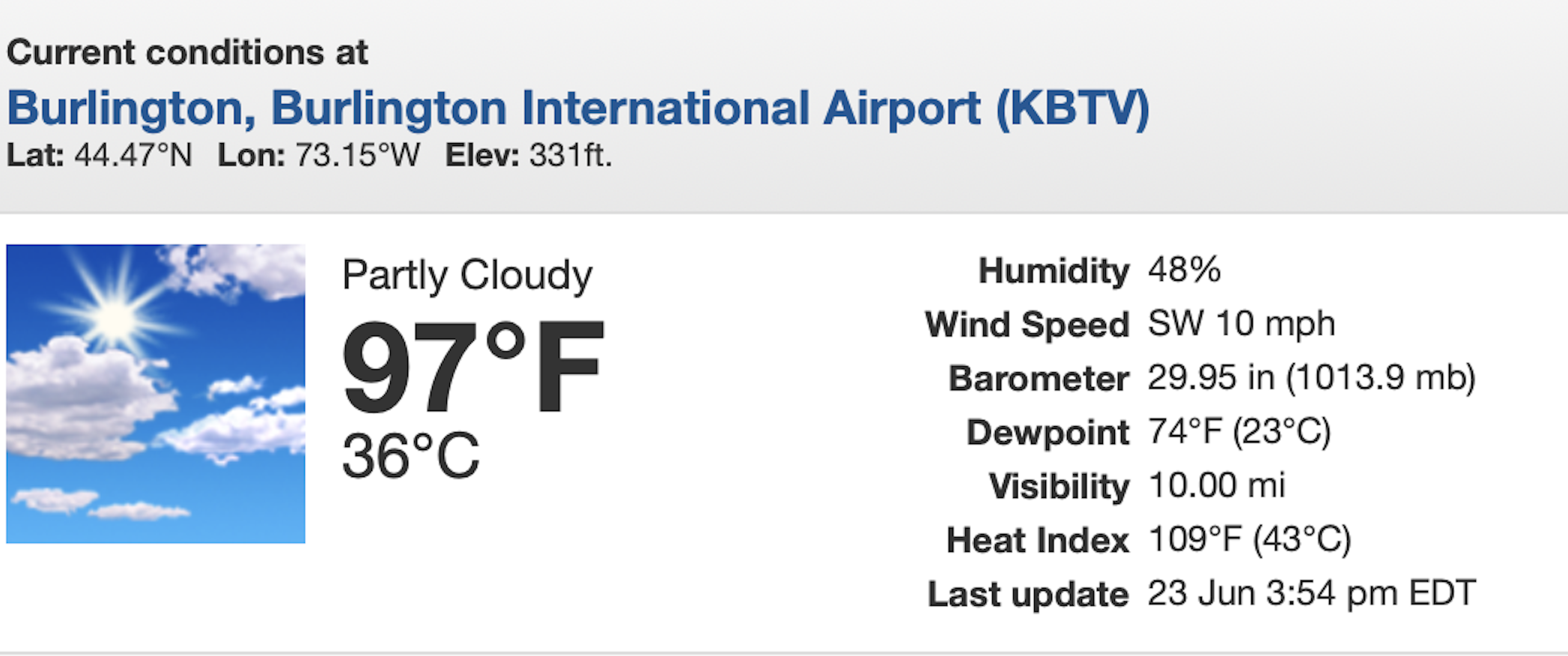
The 4 p.m. report from Burlington Monday showed
a heat index of 109. Several Vermont towns had
incredible heat index readings of 115 degrees or more, 
Humidity levels were higher than usual on Monday for a Vermont hot spell. Dew points, a measure of how humid it feels were at near record levels. 

Nobody really keeps track of record dew points, but NVU-Lyndon Atmospheric Sciences says the highest dew point seen in Burlington was 77.8 degrees at 4:10 p.m. on July 2, 2018. 

During the height of Monday's heat, the dew point in Burlington was 75 degrees. There were some reports in Vermont of a dew point at or above 80 degrees, which to me had been previously unheard of this far north in New England. '

The resulting heat indexes were brutal, especially where the humidity was especially high. Those indexes peaked at incredible - and very dangerous levels - 119 degrees at Highgate Falls, right up there near the Canadian border; 118 degrees in Colchester and Cambridge, and at or above 115 in several other Vermont communities.   

The result was a hunkered down Vermont. 

I went out and did some errands Monday. (The air conditioner in my truck was fixed just last week, phew!). Out on the streets, it sort of looked like it does during a snowstorm. Minus the snow, of course. 

Traffic was lighter than usual.   I saw very few people walking on sidewalks. Downtown St. Albans was practically a ghost town as the heat peaked in the mid and late afternoon. Outdoor construction sites were shut down and abandoned in the heat of the afternoon.  Some of the beaches were less crowded than you'd expect. It was simply too hot for the beach. 

I know this kind of weather is pretty routine in places like Houston, New Orleans and Miami. Though Miami was actually cooler and less humid than Vermont was on Monday. 

It's disconcerting to have their kind of weather here. Just as it had to be a little scary when the first-ever major snowstorm and near 0 degree cold snap that swept the Gulf Coast last  January.  

TODAY

After a terribly stuffy night, today should be almost as bad as Monday.   When I went out to water the gardens at 7 a.m. today, it was already sweltering. 

Some Vermont towns, especially north and central, might not be quite as hot as Monday because a cold front will be approaching from the north. That might throw some clouds and even a few thunderstorms into the picture this afternoon, tempering the heat just a bit.

(I'll get into those thunderstorms in just a bit)

Burlington's expected high temperature is now forecast to be 95 degrees. The record high for today is 96 set in 2003. So we might avoid a record high there today, we'll see. 

One wild card is the humidity is just a slight hint lower than yesterday.  Actual temperatures under sunshine can more easily get hotter when there's less humidity. If the clouds hold off in the north, we could shatter more record highs. 

Southern Vermont should avoid the clouds through the day, so they might actually be a little hotter than Monday. Or at least just as hot.  We'll be looking to see if anybody in Vermont's lower Connecticut Valley makes it to 100 degrees today. I wouldn't be surprised if that happens. 

THUNDERSTORMS

Usually when it's this extremely hot, the atmosphere is a powder keg, ready to explode with violent thunderstorms. It just needs a spark. 

That spark is usually a cold front. And, as mentioned, here comes a cold front. So yes, a few thunderstorms might fire up today and this evening, especially north and central, and there's a chance a couple of them could have damaging wind gusts.

But the thunderstorms probably won't be as widespread as you'd expect. There's a layer of dry air very high up in the atmosphere, which would limit how many thunderstorms can form.

Also, when a cold from is approaching, the air in the upper atmosphere usually cool first, before the less hot air arrives at the surface. That contrast between the hot surface and the colder upper atmosphere tends to fire up thunderstorms. This time, the upper atmosphere won't really be cooling much like it usually does ahead of the cold front this afternoon. This will also limit the number of storms.

BLESSED COOLNESS

You'll notice the change in the air and the temperature on  Wednesday. It'll still be warm - in the low 80s north to upper 80s south.  The humidity will be declining, especially north. The result will be a delightfully warm and dry and pleasant northern Vermont. Southern Vermont might remain a little uncomfortable, but will improve through the day.

Daytime temperatures might actually be near or slightly cooler than normal Thursday through Saturday, with highs only in the 70s.

Tonight's cold front will stall only a little to our south, so it will try to start coming back as a warm front late in the week. We'll still be on the cool side of it, but it looks like it will touch off some showers and maybe storms Friday and Saturday. 

It's beginning to looking kind of warm and somewhat humid this coming Sunday and Monday, but it shouldn't get nearly as torrid as it did yesterday and today.