
 |
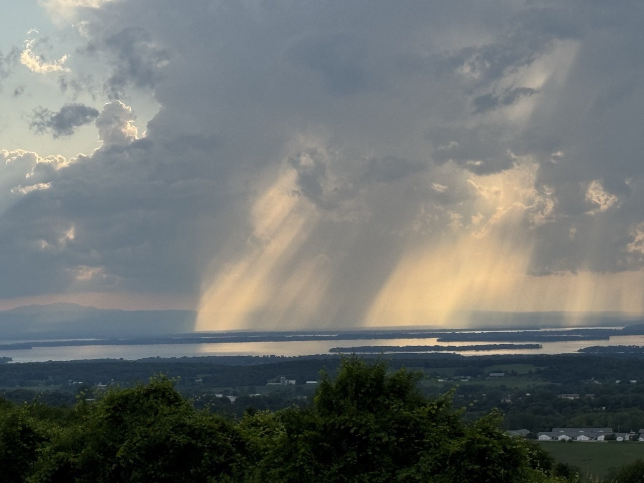
| Thunderstorms developing near Lake Champlain caused falling rain and sunshine to mix in interesting patterns, as seen from St. Albans, Vermont Thursday. Though this storm was picturesque, other storms elsewhere in Vermont caused a lot of flood damage for the third July 10 in a row. |
The worst of the trouble this time was up in the Northeast Kingdom, with reports of water in homes, swift water rescue teams rushing a respond, roads closed, and four to five inches of rain in spots.
Other flooding was reported in parts of Addison County.
At least one swift water rescue was reported along Calendar Brook Road in Sutton. They were there to "assist the residents of one home cut off by floodwater," according to a Vermont Emergency Management statement, as VTDigger reported.
Other rescue teams were staged around the state just in case.
Barton and Orleans, and other Northeast Kingdoms communities have now suffered flood damage for the third July 10 in a row. That has to be incredibly disheartening.
Damage reports from Thursday were a dime a dozen. Sheffield Road was washed out in Sutton. School Street in West Burke was under water. Route 114 was closed due to a culvert washout in East Haven. Part of Route 58 in Orleans was washed out.
A number of local town roads in the Northeast Kingdom were either damaged or closed or both by washouts and flooding.
Rainfall amounts in parts of the Northeast Kingdom were impressive to say the least. West Burke reported 5.07 inches, Sutton saw 4.92 inches. Down in Addison County, 4.32 inches fell in New Haven, where at least one road was closed by flooding.
The storms this time were hit and miss. Parts of northwest and southern Vermont saw almost no rain. Burlington reported just 0.02 inches. Montpelier reported a tame 0.26 inches, which had to be a relief compared to the more than six inches of rain Montpelier endured on July 10-11, 2023, and the more than three inches they had last year.
If you want to find a weak silver lining from yesterday, I suppose the trend line is good. Thursday's floods weren't as widespread as last year's. And the floods of 2023 were even worse than in 2024.
Almost all the damage from yesterday was in limited to the Northeast Kingdom and parts of Addison County. Last year's floods affected most of northern Vermont. The July, 2023 floods affected almost the entire state.
So each July 10 is better, maybe?
That's cold comfort to anyone who suffered damage yesterday. It was especially distressing to have another July 10 in which the weather radio was crackling with an onslaught of flood and severe storm warnings.
Still, another bright side was that some towns and cities that were hard hit in 2023 and 2024 like Barre, Montpelier and Johnson, reported little damage from Thursday's storms.
Severe thunderstorms with powerful winds also roamed parts of the state Thursday. The roof of Middlbury High School was damage by powerful storm winds. Multiple trees crashed to the ground and blocked parts of Route 125 in Middlebury and Weybridge, along with Route 17 in Weybridge.
Some tree damage was reported in Williamstown and Hyde Park
I don't know whether Thursday's damage qualified Vermont for federal disaster aid. Complicating the picture is the Trump administration is famously withholding disaster funds.
The flood and storm reports from yesterday are still coming in, so I'll update as warranted throughout this.
HEAT AND STORMS TO CONTINUE
Much like in the aftermath of the floods of July 2023, and 2024, Vermont is now settling into a weather pattern featuring hot, humid weather accompanied by some risk of additional damaging storms.
NOAA's Weather Prediction Center, keeps Vermont (and many other parts of the nation) in a marginal risk for more flash flooding Saturday, Sunday and Monday. That's the least dire of four tiers of flood risk, meaning there's a chance of isolated flash floods.
On Saturday, there's only going to be scattered storms here and there, mostly just because the air mass will be warm and humid. At this point I think Saturday's the lowest risk day, and chances are good we'll get through the day with no trouble.
Forecasters are watching the period from Sunday evening into Monday. The air will be very humid, and a weather front will be approaching from the west. (Some are calling it a cold front, but there's nothing cold about it).
We could see a few scattered instances of downpours heavy enough to cause some localized new flood issues. Again, nothing widespread, but something to keep an eye on.
Behind this "cold front" on Monday, the air will stay very warm and humid, so that thing is going to be just a thunderstorm trigger and pretty much nothing else.
A heat ridge will build in the eastern U.S. next week, ensuring Vermont will stay very warm and humid probably at least until the end of next week.
Check out these forecast daily highs in Burlington Saturday, through Thursday: 87, 89, 85, 90, 92, 92. So yeah, icky,
Vermont will also be near the northern edge of that heat dome. Clusters of thunderstorms often ride along the northern edge of these things. We'll need to be on guard for the risk of perhaps some severe storms or local flash floods again most of next week.
We don't know for sure about that. If we're lucky, everything will go by to our north. We'll have better forecasts once we get into next week.
No comments:
Post a Comment