Wednesday, June 30, 2021

New England Heat Wave To End With Some Severe Storms

Cooling centers like this one opened in the Pacific Northwest
in the past few days as unprecedented heat took hold.
There has unfortunately been a dramatic uptick in deaths
in the region due to the heat
 We'll have to watch the skies for severe storms today, especially from Route 2 south in Vermont, and especially from Route 4 south and on through southern New England and the New York metro area today. 

More on that in a minute and what it means for us  in a minute (Spoiler: It will help end the heat wave)

But the heat both out west and to a slightly lesser extent here in the Northeast continues to impress. 

Following is a hodgepodge of facts and figures that proves that point. 

CANADIAN HEAT AND TRAGEDY

The most impressive stat so far is from Lytton, British Columbia, Canada. As previously reported, that town on Sunday broke the record high for all of Canada with 116 degrees. That record lasted a whole day, as Lytton reached 118 on Monday. And THAT record was brief, too, as Lytton hit an astounding 121 degrees on Tuesday.

I saw one statistic that showed the previous world record high for that far north in latitude was 112 degrees.

There were many worries the extreme southwestern Canadian heat would lead to a large number of deaths in the part of the world where 100 degree heat - especially heat like that lasting for days, would lead to a number of deaths. 

Those fears have unfortunately been realized.  Authorities in the area around Vancouver, British Columbia are investigating more than 130 sudden deaths, most of which are suspected of having been caused by the extreme heat. 

Here's a tragic quote via the BBC:

"'I've been a police officer for 15 year and I've never experienced the volume of sudden deaths that have come in such a short period of time," police sergeant Steve Addison said. Three or four a day is the normal number."

The Canadian heat wave death toll is expected to rises, especially since the extremely hot weather is continuing today and beyond in southwestern parts of the country.

PACIFIC NORTHWEST

Deaths are above normal in the northwestern United States due to the heat as well. A farmworker in Oregon has died in the hot weather, and other fatalities are being investigated as possibly heat related as well.  Hospital emergency rooms have seen a surge in patients with heat related illnesses.  One person was treated for third degree burns on his feet from walking barefoot on asphalt. 

The heat has waned near the coast. Seattle set by far it's all time record hottest temperature on Monday with 108 degrees but it was "only" 85 degrees there Tuesday. Portland, Oregon went from an all-time high of 116 degrees Monday to 93 degrees Tuesday.

The heat continued inland, though. Spokane, Washington suffered through an all time record high of 109 degrees Tuesday, and it could get that hot again today. 

This heat wave is forecast to linger in the interior Northwest through the weekend at least, and spread into the Northern Plains. 

NORTHEAST HEAT

The heat wave in the Northeast has been on the impressive side as well. 

Hartford, Connecticut reached 99 degrees Tuesday for a new record high.  Boston also reached 99 degrees, tying the record for the date. 

It appears Portland, Maine will have its hottest June on record. Boston and other New England cities will come close.  

In Burlington, Vermont, we're on track to have our third hottest June on record, or perhaps second warmest, depending upon how today goes.

Tuesday was already the eighth day this year in Burlington with a high of 90 degrees or more.  The record for a single season is  26 such days.  We still have July and August to get through. 

The heat is already to begin to wane in the far north, and should disappear in most places in the Northeast by tomorrow, but there's a price to pay for that
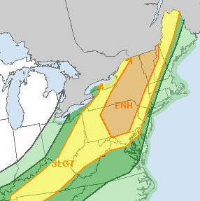
SEVERE WEATHER 

Things seem very well set up today for a burst of severe thunderstorms in central and southern New England.

In Vermont, the most likely area for severe weather is from about Route 2 south, with the threat increasing the further south you go.

Far northern Vermont is closest to the cold front that will end the heat wave.  It's already cloudy up that way, which will sharply reduce instability, which is one key ingredient you need for severe thunderstorms. 

The threat of severe storms is highest in central
New England today, but almost the entire
region could see a strong to severe storm.

Also, as is common with severe weather potential in our region, there's a pre-frontal trough, sort of a mini weather front coming in first.  Severe storms usually for along and ahead of such a trough.  The pre-frontal trough will have already gone through northwestern Vermont by late this morning, minimizing but  not eliminating the threat of severe weather in that area.

This also reduces the chances of that area getting needed, decent rains. 

One technical thing meteorologists look for when forecasting thunderstorms is Convective Available Potential Energy or CAPE. it refers to the maximum speed of potential updrafts in thunderstorms.  Strong sunshine can increase instability, and thereby increase CAPE values. 

The higher the CAPE value, the higher the probability of severe storms.  If the CAPE value gets really high, you can get particularly intense storms. 

There are other factors you need to create severe weather, but if CAPE values start to go above 1,000, that's one sign of potential strong thunderstorms.  If you get up around 3,000, you really want to watch out, if other atmospheric conditions are there to contribute to storms. 

Projected CAPE values today ranged from near 900 in far northwestern Vermont, to as high as 3,000 in southern Vermont.  Parts of southern New England close in on 4,000. I'm sure we'll see at least a few reports of strong damaging winds the further south you go today.

The Storm Prediction Center has the best chances of severe thunderstorms in central New England. By far the biggest threat is strong, straight-line winds.  Like in the last severe weather event earlier this month, there is a very low, but not zero chance of a brief tornado in southern and eastern Vermont New Hampshire and Maine.

We still need rain. Southern Vermont and southern New England have been doing a little better lately with rainfall. Northern Vermont continues to keep missing out.  

And of course that trend will continue.  There's still a good chance of some rain in the north with showers and thunderstorms, but I don't think it will amount to a whole lot, except for the lucky few that get bulleyed by a couple local downpours.

The cold front will get hung up near or just south of the New England coast, and it looks like a small storm will form along it. This will spread rain back northward Friday, but again, northern Vermont looks to get lighter amounts from this. 

It will temporarily get much cooler under the clouds and rain, with some places in eastern Vermont staying in the 60s or highs on Friday.  It'll warm up again by Sunday and Monday.  

Tuesday, June 29, 2021

Northwest Extreme Heat: Could It Happen In Vermont?

Despite constant watering, the river birch we planted in
our yard is still suffering a bit as it is enduring one of 
the hottest Junes on record.  While we have not
experienced the kind of extreme heat that has happened
elsewhere in the world lately, there's no reason why
new all time records can't be set if weather patterns
 align themselves just right. 
 As we've been talking about all week, the Pacific Northwest and southwestern Canada have been broiling in an unprecedented heat wave.  All-time records have been shattering left and right. 

We here in Vermont are experiencing a nasty heat wave, if I can be Captain Obvious here. 

Today, Burlington will almost certainly go over 90 degrees, making three consecutive days in a row with such temperatures. That makes it an official heat wave. 

This has been a fairly intense heat wave by New England standards.  Burlington, Vermont has continuously been above 75 degrees since 3 p.m. Saturday, so there's been no relief at night.  

Though northern Vermont will turn slightly cooler tomorrow and Thursday, a few towns in central and southern New England could make it to 100 degrees today and tomorrow. 

Our heat wave has of course been overshadowed by the the brutal, extreme heat in the Pacific Northwest and southwestern Canada, which somehow managed to get even worse on Monday.

The entire nation of Canada saw its all time record high broken, with a reading of 118 degrees in Lytton, British Columbia. The old record of 116 was set just the day before in the same town. 

Seattle reached 108 degrees Monday. The old all time record high for the city before this heat wave was 103 degrees. 

Portland, Oregon, reached a blast furnace like 116 degrees, and the old record high for the city was just 108 degrees. 

Through Monday, at least 25 U.S. cities and 34 in Canada reached new all-time record highs, says the Weather Channel. 

A normally chilly town named Quillayute, Washington reached 110 degrees, breaking their all time record by a whopping 11 degrees. You don't break that kind of record by such a wide margin, but there you go. 

Normal high temperatures in Quillayute this time of year is in the mid-60s, so it getting that hot there is pretty much the equivalent of our Burlington, Vermont getting up to 125 degrees. 

This all begs the question: Can something so unprecedented happen here in Vermont?

Well, it won't get to 125 degrees in Burlington, not even close. But with climate change taking hold, I think current all time record highs in Vermont are in jeopardy one of these summers.  In my opinion, probably within the next couple of decades. 

For perspective, the hottest temperature on record for the entire state of Vermont was 105 degrees in Vernon, July 4, 1911. Yeah, that was a long time ago.   Burlington's all time record high is 101 degrees from August, 1944.  It's only been 100 degrees in Burlington four times, in 1911, 1944 and twice in 1995.

Meanwhile, unprecedented heat waves have been hitting different parts of the globe with increasing, alarming frequency. Sure, records are made to be broken, so it's inevitable that some place in the world will occasionally have an all time record high temperature. The pace of such record heat waves has picked up markedly, though. 

In recent decades, though, massive heat waves have been obliterating records. Such heat waves have struck not just the Pacific Northwest, but Russia (in 2010) and western and central Europe (2003).  Many other areas of the world have had all-time record highs.

In July, 2019 new national heat records were set in France, Belgium and the Netherlands.  

Last year a reading of 100 degrees was noted for the first time north of the Arctic Circle, in a Russian town. 

Just this year, places as diverse as Helsinki, Finland, and Mexicali, Mexico broke their all time record highs for June (89 and 125 degrees, respectively.) Billings, Montana and Salt Lake City, Utah broke their all time records in another heat wave earlier this month, with readings of 108 and 107 degrees. 

Here in Vermont, we haven't hit all time record highs in recent years, but there have been a flurry of new monthly records, and records for earliest and latest in the season heat. 

Eight of the 12 monthly high temperatures in Burlington have been set since or tied since 1995. The city's records go back to the 1880s.

There have been days that have broken records by huge margins. In February, 2017, the temperature in Burlington reached 72 degrees. Prior to that year, February temperatures had never exceeded 62 degrees. On Christmas Eve, 2019, it was 68 in Burlington and 70 in Rutland. Last year on Christmas Day in was 65 degrees.

So we now seem at least somewhat prone to breaking records by large margins. 

If the weather patterns align themselves perfectly in the middle of summer, that combined with global warming, could really shatter all time record highs in Vermont. 

Which is potentially very dangerous, because we're not used to extreme heat. 

The chances of these records shattering this year or on any given year are very low, but it's something that could happen. 


Monday, June 28, 2021

Canada And U.S Pacific NW Set All Time Record Highs; Heat Drones On In Vermont, Too

A Seattle resident sticks his head in a bucket of water
to cool off during that city's hottest day on record on
Sunday. Photo by Sylvia Jarrus, Seattle Times
Sunday was quite a day if you love to see weather records broken. 

The heat wave in the Pacific Northwest and southwestern Canada continued to be mind-blowing on Sunday.  

The temperature reached 116 degrees in Lytton, British Columbia Canada, making it the hottest temperature on record for any date, anywhere in Canada. 

The old record high for the nation was 113 degrees in the Dust Bowl days, July 5, 1937 at two locations in Saskatchewan.  

It's unbelievable to have a national heat record, particularly in a nation as large as Canada, broken by three degrees. Even more amazingly, it's possible that new Canadian national heat record could be broken again today as the heat drags on.

In the United States,  Seattle, Washington set its all time record high Sunday, reaching 104 degrees. The "low" temperature in the morning of 73 degrees was also the warmest minimum reading for any date. The city could break that high today, with a forecast high of 105 degrees.

To nobody's surprise, the heat is proving to be dangerous. On Saturday alone, 41 people went to Seattle area emergency rooms with heat illnesses, according to the Seattle Times.  The previous single-day record for heat-related emergency room visits was nine. Data from Sunday isn't in yet, but I imagine it's even worse. 

Hoquiam, Washington, normally a chilly, damp city right on the Pacific Ocean, reached their all time high before 11 a.m., which is pretty incredible since high temperatures during a heat wave usually peak in the late afternoon.

By late afternoon, Hoquiam peaked at 103 degrees. The old record for the date was 88 degrees and normal high temperatures there this time of year are usually only in the mid-60s. Further inland, Pasco, Washington hit 115 degrees.

Portland, Oregon also had an all-time record high of 112 degrees, beating the old record by four degrees. That old record, by the way, was just set Saturday, a day earlier. 

More all time records will probably be set today, but the focus of the heat will be just a little further inland. The heat should abate pretty quickly this week right along the coast.  For instance, after an expected record high of 97 in Hoquiam today, daily highs will be in the low 70s the rest of the week. 

The heat, however, will continue blazing on all week in interior Washington and Oregon. In the eastern Washington city of Spokane, it will be in the 100s daily through Saturday, but it will "cool" from an expected high Tuesday of 113 all the way down to 101 by Sunday. Normal high temperatures this time of year in Spokane are in the upper 70s, so this is really extreme and long lasting for them.

Interior Oregon will also have daily highs in the 100s all week.  Note that the longer a heat wave lasts, the more dangerous it is. 

VERMONT/NEW ENGLAND HEAT

We here in Vermont and the rest of New England are feeling the heat, too. At least it's not as extreme as out west but it's plenty warm. 

Burlington, Vermont reached 94 degrees Sunday, not a record but up there.  That's the sixth time it's been 90 or better this year, which is normal for an entire summer. Five of those days were at least degrees.

The nights have been the more impressive aspect of this hot spell in Vermont. Yesterday, Burlington broke its record for the warmest low temperature for the date, as it only got down to 75 degrees. Montpelier only got down to 72 degrees Sunday morning, breaking its record for highest minimum for the date.

Even the notorious cold spot Saranac Lake, New York, which hit the freezing mark of 32 degrees twice last week, only got down to 69 degrees Sunday morning. 

It was just as bad this morning. 

In Burlington, it was still 80 degrees at 5 a.m. today. Montpelier was 81 at that hour and it was 80 degrees at my place. Those without air conditioning had an awfully stuffy night. 

The highest "low" temperature for any date in Burlington is 80 degrees.  It did slip below that reading by 7 a.m., driven down ever so slightly to 76 degrees by light rain showers. But still. Ick. 

It'll be another hot one today, with Burlington and many other New England cities very likely to top 90 degrees again. Heat advisories that were up in southern New England have been extended northward today into the Champlain and Connecticut River valleys of Vermont. 

Heat indexes should be in the upper 90s in these areas today. 

Some early showers did break out this morning, but didn't amount to much.  There's a risk of some widely scattered thunderstorms this afternoon, but the vast majority of us won't see any rain. 

Rain is also unlikely Tuesday and it will be almost as hot. The next decent chance of rain is on Wednesday, and the end of the week is looking cooler. 

Sunday, June 27, 2021

A Mild Thundershower Video For Use This Winter

Nothing like a pleasant evening thunderstorm to help
us love summer even more
 It's hotter than blazes outside this afternoon as temperatures soar toward and above 90 degrees as we head toward the heart of summer.  

Soon enough it will be cold again here in Vermont. Even in a climate-changed world, winters are still long.  That's not to depress you, but to offer a little gift for when we're in the depths of winter. The Christmas season is only six months away after all.

Last Monday, when other parts of Vermont were on the receiving end of thunderstorms and over the border in Quebec they had tornadoes, there was a mild evening thundershower in St. Albans, Vermont.

There's nothing like the sounds, feelings and sights of a gentle thunderstorm. The flashes in the sky, the rumble of thunder rolling above the mountains, the muggy, heavy organic aroma to the air, the pitter-patter of raindrops on the leaves. It makes for a quintessential summer evening, and something to hang onto for the winter.

So, I made a video, which is below. Call it back up one cold winter day, and it will take you back to the gentle, humid warmth of summer. As always, click on the arrow in the center then the YouTube logo to make the video bigger and easier to see


As Expected Heat Records Crashing In NW: New England (Smaller) Heat Wave

Today's national weather map shows an immense area
of extreme heat warnings and heat advisories in the West.
Some heat advisories are also showing up in the Northeast
(orange areas) 
Before we get into what's going on around here in Vermont, I really have to marvel at the heat in the Pacific Northwest.  

That region of the nation hasn't even reached the peak of their heat wave yet - that will come today and tomorrow - but record high temperatures were already crashing down, especially in Oregon, Washington, and British Columbia, Canada.

Portland, Oregon rocketed up to 108 degrees Saturday, reaching an all-time high for any date in that city. The scary thing is that new all time record will likely be broken today, and broken by a wide margin. 

The Weather Channel forecasts a high of 115 degrees in Portland today.  

For perspective,  it will be cooler in 99.8 percent of the world today than in Portland. Only parts of the Sahara Desert, Persian Gulf and a few spots in the Desert Southwest will be hotter. Portland is normally a pretty mild city.  Normal high temperatures there this time of year are in the upper 70s.

Seattle hit 102 degrees Saturday, a new record for the month of June.  The record for the date was broken by a whopping 12 degrees. Where this record was set, normal high temperatures this time of year are only in the low to mid 70s.

A weather balloon launched Saturday didn't hit the freezing point until it reached 18,700 feet, something unheard of for this part of the world. That's 4,300 feet above the summit of Mount Rainier, so I'm sure the snowfields and glaciers are melting rapidly up there. 

In Lytton, British Columbia, the temperature reached 110 degrees Saturday, the hottest reading for anywhere in Canada for the month of June.

The incredible heat wave in the Pacific Northwest will peak today and tomorrow before only slowly waning. 

Heat waves are always dangerous, as hot weather is the world's leading meteorologically cause of deaths.  The Pacific Northwest is not used to such hot weather, and many buildings and homes have no air conditioning.  It could get deadly. 

That's especially true since early morning low temperatures aren't offering much relief, making the heat wear down on people. The low temperature this morning in Seattle was 73 degrees, the warmest overnight low on record for any date. 

As NBC News/Associated Press reports, people have done their best to get ready for the heat wave.

"Stores sold out of portable air conditioners and fans, hospitals canceled outdoor vaccination clinics, baseball teams canceled or moved up weekend games and utilities braced for possible power outages."

As climate change continues on, heat waves are getting hotter, longer lasting and more frequent. This one is an outlier that might not be repeated in the Pacific Northwest anytime soon. But like most other places, strong heat waves have become more likely in that region and will continue to get more likely going forward. 

 VERMONT/NEW ENGLAND UPDATE

We in the Green Mountain State are among the many areas becoming more prone to hot spells.  We've seen that already record spring, summer and autumn heat this year, and every year since 2017. 

A few record highs could be threatened in New England today and tomorrow as we get our own hot spell. At least it's not as extreme as the one in the Pacific Northwest.  But it's bad enough.

Today has already gotten off to a muggy, icky start.  The low temperature in Burlington this morning was 75 degrees, compared to a normal low of 60.  That gives a good head start to the heat today.  We'll probably fall perhaps just two or three degrees short of the record high of 96 degrees for today's date. 

I'd say today's record high of 91 degrees in Montpelier is threatened. Other record will surely fall, especially in southern and eastern New England, which have the right conditions for the hottest temperatures. 

After a very stuffy night, Monday looks pretty brutal, too.  It's possible northern Vermont will be just a couple degrees cooler than today, but still hot. Clouds could keep temperatures in check a bit, and a slightly cooler upper atmosphere might hold temperatures back a degree or two.

However, if anything, southern and eastern Vermont could be even a bit hotter on Monday than today, and more record highs are threatened. Tuesday's temperatures in Vermont will drop a few more degree, though the intense heat will continue in central and southern New England. 

We sure do need the rain, and there are chances coming up.  Saturday, my place in St. Albans was probably the wettest spot in Vermont, which is the good news. The bad news is it only amounted to 0.3 inches, which isn't much. 

Most places in Vermont got either nothing or less than a tenth of an inch. 

Only isolated thunderstorms are possible today. There might be slightly higher coverage of storms Monday, but most of us will stay dry. 

A weather front stretching from Oklahoma to central Quebec has been for the past few days a conveyor belt for flooding rains. 

That boundary should slowly slip south into our area over the course of the week. There won't be flooding rains, and we don't even know yet whether there will be fairly decent rains. But at least the chances of some rain increase Tuesday through Thursday.

That weather front will also gradually decrease our temperatures through the rest of the week. It will stay kind of humid, though.  

Saturday, June 26, 2021

Tornadoes In Odd Places Wreak Havoc. Also, A Quick Non-Tornadic Vermont Update

Extreme tornado damage in the Czech Republic this week. 
Tornadoes and severe thunderstorms are a common hazard in the United States in early summer, but lately, the news is filled with news of tornadoes in places worldwide you don't necessarily expect.

Damaging tornadoes have struck the Czech Republic, China, London, England, and as we talked about the other day, Quebec. 

CZECH, LONDON TORNADOES

Arguably the worst of the tornadoes hit the Czech Republic

The tornado in the Czech Republic trashed several villages along a 15-mile path. In addition to the five deaths it caused,  about 100 people were injured and many homes damaged or destroyed.  In one village with a population of 1,600 people, at least one third of the houses were destroyed and only 15% of them were fully intact, said the BBC.

Judging by the photos, this was probably an EF-3 or EF-4 tornado.  

Scary video of this tornado taken by somebody as it approached, then trashed their house while they were inside. Pro tip: When there's a tornado, hide in basement or sturdy interior room. Stay away from the windows!!

Tornadoes are common in Europe but strong ones aren't. In the decade ending in 2020, there were 3,827 tornadoes in Europe, but only 28 of them were strong or violent, meaning EF-3 or higher, according to the European Severe Storms Laboratory. 

Specifically in the Czech Republic, tornadoes are rare and tend to be weak, not violent like the one this week.  The nation usually gets a few weak tornadoes each year. 

A couple of these relative weaker, but still dangerous tornadoes hit other European countries this week Video showed a tornado unroofing a hilltop building in France.

Another apparent tornado hit Barking, in east London Friday. Video on social media showed a whirl in the clouds that looked a bit like a cinnamon bun, and debris swirling in a circle beneath it. Video on social media from one Barking neighborhood showed trees snapping off, roof tiles lifting off buildings and walls lining yards toppling. 

The UK on average has about 35 tornadoes per year, most of them comparatively weak like the one Friday in Barking, London

CHINA TORNADO

A violent tornado struck China's Inner Mongolia province Friday, with six people recorded there.  This is reportedly the sixth violent, damaging tornado in China this spring and early summer. Other than this one, one of the worst was at the start of the month, when another strong tornado hit China's northeast Heilongjiang province, killing one person and injuring 16 others. 

QUEBEC UPDATE

As we reported earlier this week, an EF-2  tornado hit a suburb north of Montreal Monday, killing one person and causing widespread damage to homes in the town of Mascouche.

It turns out that was one of four tornadoes in the severe weather outbreak in Quebec Monday. Another, weaker tornado hit St. Valentin, Quebec.  This was only 14 miles north of Alburgh, Vermont.  I watched that parent supercell on radar, starting from when it caused straight line wind damage in the northern tip of New York.  Radar images did look tornado-ish to me as the storm crossed into Quebec. Now we know.   

This home was pulled from its foundation and destroyed
by a tornado in Quebec on Monday.

There were rotating storms in Vermont that day that had the potential to unleash brief tornadoes, but none are known to have touched down. 

Another tornado hit in central Quebec and another struck just south of Quebec City on Monday. 

VERMONT FORECAST

Certainly no tornadoes are in the Vermont forecast for the next few days. 

There will be heat, lots of humidity and slim chances of needed rain over the next few days. There's potential for a better chance of rain later in the week, but we'll have to wait and see on that.  

Showers were trying to skirt far northern Vermont this morning.  I've had just sprinkles so far here in St. Albans, Vermont.  There might be a few more showers, especially north today, but I don't think it will amount to all that much. 

Sunday and Monday will be classic summer days, with many of us around 90 degrees with high humidity. Nights, of course will be stuffy.  Only widely scattered showers and storms will pop up in the afternoons and evenings but most of us won't see any activity. 

Depending on where a slow moving or stalled weather front sets up in the second half of the week, we have a shot at some decent rains, but a lot can go wrong with that prospect. The front will stall, or nearly stall somewhere. If it stalls over or close to us, we get a jackpot of rain, 

But the way our luck is, it's stalled now over southern Quebec, bringing rain there. Then it could zip right through Vermont, giving us little rain, then stall to our south, giving them the precipitation. 

I'm totally unsure on that one, but the chances of missing out again seem real to me. Stay tuned! 

Video of the Czech tornado. Click on the YouTube logo to make it bigger and easier to see:


Friday, June 25, 2021

Extreme Heat, Drought Continue To Rage In Climate Change Fueled Summer

One computer model depicting the temperature 
departure from normal in the Northern Hemisphere.
Dark reds and black shading is much above normal,
light purple is much cooler than normal. Huge
areas will be hot and the only really chilly areas
will be the central U.S. and a small slice of Ontario.
This is another week in which the weather has really gone off the rails in many parts of the world. 

We've been talking about that heat wave that is beginning now in the Pacific Northwest of the United States and British Columbia, Canada.

 If anything, the forecasts have gotten worse, with all time record highs very likely to be challenged in these regions. 

Drought in the western United States, already extreme in many areas, is rapidly worsening and turning into a crisis. 

Meanwhile, a large chunk of Europe is also dealing with its own record-breaking heat wave.   I'll save it for a soon to be released subsequent post on all the other weather problems out there this week, including tornadoes in weird places and flooding. 

But the heat is the main story here. 

In most of the northern hemisphere, summer heat peaks in July, weeks after the summer solstice. The kind of heat waves going on now, if the happen at all, are unprecedented for June, this early in the year. 

While temperatures relative to normal today vary across the Northern Hemisphere, like they always do, there is almost no cool air. The only places by Sunday that will be noticeably cooler than normal will be parts of the central United States and a slice of Ontario, Canada.

Here in Vermont,  we won't be nearly as extreme as these examples in the coming days.  We won't set any June or all-time records. But we are still going to be dealing with another oppressive hot spell and possibly a worsening drought in the coming days. More on that in a moment. 

I say this every time I bring up these big heat waves, but it bears repeated.  Although there have always been heat waves, the longer and more intense ones we've been seeing in recent years are being influenced by climate change.  

The overall warming world helps turn run of the mill hot spells into torturous heat waves. The droughts are probably influenced by climate change, too, as hotter, drier air causes more evaporation, making droughts worse. 

 NORTHWEST HEAT

If anything, forecasts for the heat wave building in the Pacific Northwest and British Columbia are even worse than before. Some examples: 

A high of 109 degrees is forecast in Portland, Oregon Sunday. That city's all time high is 107.

Spokane, Washington is expected highs of 110 degrees Monday and Tuesday. That city's all time high is 108 degrees.

Yakima is forecasting a high of 113 degrees Tuesday. 

It's possible that it could reach 112 degrees in southwestern British Columbia, Canada. If it gets that hot, it would tie the record for the hottest temperature in history for all of Canada. 

DROUGHT

According to the U.S. Drought Monitor, 90 percent of the West is in drought and 50 percent of that area is extreme or exceptional drought, the two worst categories. By many assessments, this is probably the worst on record out there. 

Monsoon moisture seems poised to come into New Mexico and maybe a few spots in Arizona and southern Utah, which might help some communities a bit. But the rest of the region will just keep baking and stay almost rain-free for the foreseeable future. 

EUROPE HEAT

Early season  heat is also ongoing in Europe. 

According to the Washington Post, Moscow and St. Petersburg, Russia, Estonia, Belarus, Malta and Hungary in the past few days all established new records for the hottest temperatures record for June. 

Helsinki, Finland, also broke its all-time record for the month of June with a high of 89 degrees.  Yerevan, the capital of Armenia, also set at new June record with 104 degrees. Sarajevo, Bosnia had a June record for the third straight day with 101 degrees, as reported in the Washington Post.

Last Sunday was the fourth consecutive day that 95 degree weather was reported in Germany. 

The heat will last into the weekend, with epicenter of it being in and near western Russia over the next few days. 

 NEW ENGLAND HEAT

Here in Vermont and most of the rest of the Northeast, and southern Quebec, the pleasant weather of the past few days is about to fade into another hot spell.

This will not be as extreme as the Pacific Northwest, but it will still have its impacts.  At this point, Sunday and Monday will be the worst, with highs topping 90 in most of the warmer valleys of northern New England and in much of southern New England.  Some places in southern and central New England have an excellent shot of reaching 95 degrees or a little more Sunday and Monday. 

A few daily record highs might he challenged here and there, but we definitely won't come close to all time highs like places such as Oregon and Washington State will. 

The humidity will of course stay way up there as well, so nights will be stuffy and not great for a good night's sleep during the upcoming week. 

Although it might not be as hot after Monday, there are signs the very warm and humid weather could last all the way to Friday. That's uncertain at this point, as it all depends on the timing of a cold front that will be trying to make a run at that Bermuda High. 

If stronger than expected, the front could cool us off as early as Wednesday. Or it might wait until Friday or even beyond that. Time will tell.  

Hopes for decent rains are now dashed, too, at least until the middle of the week.  With the hot northwestern extension of the Bermuda High being the main influence, only widely scattered showers and thunderstorms will dot the landscape Sunday through Tuesday.  If anyone gets any of these storms, the best chances are near the Canadian border. But even there, don't hold your breath on these.

There might be a better chance of showers and storms mid to late week, but that's still iffy. 

Thursday, June 24, 2021

Rainfall Roulette: Will Squeeze Play Between Two Heat Waves Bring Needed Precip?

A rainfall forecast for the nation for the next several days.
Reds and oranges depict heavy, likely flooding rains in
the Midwest. The heatwave-plagued Pacific
Northwest would be bone dry. Here in Vermont,
we're on the southeastern edge of all that rain.
 The United States has a pretty unusual weather pattern setting up, especially for this time of year, which makes some aspects of weather forecasting tricky for our neck of the woods around Vermont and nearby spots. 

The jet stream is more amplified than it normally is for summer. Big ridges will be near both coasts, with a deeper than average dip in between. This sets up some weather extremes. 

As we talked about yesterday, a record-shattering heat wave is set to begin in the Pacific Northwest and British Columbia. 

Here in Vermont, it's another delightfully cool morning. Most of us were in the 40s at dawn today. 

That notorious cold spot in the Adirondacks of New York, Saranac Lake, touched 32 degrees for the second morning in a row. There were also a few upper 30s in Vermont's Northeast Kingdom

Today will be nice, too, breezy and mild and not humid.  But here, too, we're going to get into the heat and humidity by Sunday.  This will all be caused by the Bermuda High poking northwestward to bath us in tropical air. This will be the East Coast ridge.

 It won't be nearly as bad here as in the Pacific Northwest, but we're still in for temperatures well into the 80s to maybe around 90 toward Sunday and Monday, and perhaps beyond. 

Between these two heat waves there will be a lot of rain over the next week or more stretching all they way from New Mexico up through the Midwest and on into Ontario and western Quebec. 

After the stories about the extreme heat in the Northwest, you'll probably hear of flooding problems in that long band. 

I'm pretty sure this overall broad brush forecast for the United States and southern Canada are pretty damn accurate. 

The problem is in the details for us in Vermont. The edge of that big rainy band will be just to our northwest. 

How much of that needed rain will creep into the Green Mountain State? Some forecasts have the northwestern extension of the Bermuda High dominating, keep us hot and humid with just widely scattered afternoon and evening thundershowers.  Which means very little rain. 

Other forecasts have weather fronts with that band of wet weather making runs at us from time to time nexrt week, giving us decent amounts of badly needed rain. The best chances of that happening are over northwestern Vermont, with the smallest chance to the southeast. 

NOAA's Weather Prediction Center is fairly bullish on rainfall over the next seven days, giving most of Vermont roughly an inch of rain over that time period. An inch of rain per week is pretty close to average this time of year. 

Don't bet on that, though. It could still go either way. For now, I'm really not trusting forecasts for rain more than two days out.  We do know the earliest chance of rain for Vermont is Saturday.  At this point, it does not look like any showers that do get going on Saturday will be particularly heavy. 

After that, we'll just have to wait and see as to whether the rain gods smile on us or not. 

Wednesday, June 23, 2021

Hot Where It Usually Isn't, Cool Where It's Usually Hot

Some of the computer models are predicting areas of
extreme heat in Washington, Oregon and northern 
California with some places above 110 degrees.
Another record breaking heat wave is about to settle in to part of the nation, as these huge hot spell keep roaming the world this summer, causing misery - sometimes in places that aren't used to it. 

This time, the record heat is forecast to settle into the Pacific Northwest - Oregon, Washington, and Canada's British Columbia. Once again, we'll hear news of all-time heat record being challenged or broken. 

Meanwhile, here in Vermont, we had quite a cool morning. Not record breaking, but certainly cool for the season. Enjoy the fresh breezes and low humidity today and tomorrow as we, too, are in for hot and humid weather. 

It won't be record breaking heat like in the Pacific Northwest, but still oppressive. I'll get into more of that in a minute, but first the real news. 

Seattle has only been at or above 100 degrees three times in the past century. I saw one forecast that indicated Seattle could have three days in a row starting this weekend with 100+ temperatures, though that forecast is very iffy.  

By the way, Seattle is the least air conditioned major city in the United States. It's usually cool enough there so that they don't need it.  The lack of air conditioning makes the upcoming heat wave especially dangerous. Even worse, it will last several days, so the heat will wear down vulnerable people, and could prove fatal

Eastern Washington State is normally hotter and more arid  than near the coast, but even there, the heat wave is forecast to break records. Spokane, Washington is forecasting a high temperature of 108 degrees Monday, which would tie their all time record high for any date. 

Some computer models are forecasting highs in the 110s for parts of eastern Washington by Monday. Yakima, Washington could hit 110 degrees. Forecasts call for highs of 107 in Medford, Oregon and Boise, Idaho.

Idaho is already suffering from the weather. Dust storms roared through central Idaho Tuesday as outflow from mostly dry thunderstorms caused winds of 60 mph in spots, creating dust storms. 

Boise, Idaho is expected to have six consecutive days with temperatures of 100 degrees or more with this heatwave. On average, that city has only five days with 100 degrees in an entire summer. 

North of the border, record heat has already enveloped British Columbia. Two towns there, Hope and Squamish, had their hottest temperatures on record for the month of June this past Sunday. 

This heat wave comes on the heels of another record heat wave in the Southwest last week. Phoenix, Arizona, was at or above 115 degrees for six days in a row, which is a record long streak for them. Tucson had a record long streak of 10 days at or above 110 degrees.

This endless series of record breaking and long lasting hot spells is consistent with climate change.  Scientists have long told us that heat waves would get more intense as the world overall warms, and that really seems to be coming true.

That's not to say you can't have cool weather. Sandwiched between the record heat in the Northwest and what is expected to become an oppressive spell in the Northeast, parts of the southern states should stay, by their standards anyway, cool.

Lots of places in the Mid South and Gulf Coast will have high temperatures in the coming several days in what is for them the nippy 80s.  

MORE VERMONT HEAT

Up here in New England, that cold front meant business once it established itself. Afternoon temperatures in northern Vermont were running at least 15 degrees cooler than average Tuesday afternoon.

Virtually all of us were in the 40s this morning. There might have been a touch of frost in the traditional cold spot Saranac Lake, New York, where the temperature briefly reached 32 degrees this morning. 

Enjoy it while you can. After gorgeous days today and Thursday, the warmth and humidity will start to creep up Friday. From Saturday onward to at least Tuesday, it looks warm and very humid. A piece of that famous heat pump, the Bermuda High, is expected to poke northwestward toward New England, causing the heat. 

As noted, it won't be record-breaking, but still up there. Daily highs will be well into the 80s, with maybe a few 90 degree readings popping up here and there. 

Because of the high humidity, nights will stay warm and muggy, not refreshing like last night. 

This northwestward bulge of the Bermuda High will keep a weather front nearly stalled somewhere in the Northeast or Great Lakes area. 

It it stalls close enough to us, we'll get some beneficial showers and thunderstorms during this muggy period.  If the hot high pressure system really asserts itself, the bulk of the showers and storms would say well to our north and west, leaving us with just paltry, widely scattered and brief afternoon thunderstorms.

For those of us who want rain, the best chances of it will be the further north and west you go in the region.  It looks like the earliest chance of rain for us is Saturday night. 


Tuesday, June 22, 2021

Storm Summary: Some Towns Blasted As Expected, Others Miss Needed Rains

Storm chaser Colton Flint (@Tornadof123) captured this
rotating part of a thunderstorm near Wallingford,
Vermont on Monday. 
As expected, severe thunderstorms and even supercells menaced parts of Vermont Monday afternoon, creating pockets of damage where the strongest storms roamed. 

The severe weather came in stages.  

The first round were a smattering of mini supercells that formed ahead of the main line. Most of the supercells either formed in Quebec or stayed up there, or got going in northwestern New York and moved to Quebec, largely sparing Vermont.

This was expected. Though forecasters said there was a low, but not zero risk of tornadoes in Vermont, Quebec was in bigger danger.

While no tornadoes are known to have touched down Monday in New York and Vermont, at least so far, there was at least one destructive tornado north of the border. 

In Quebec, a tornado touched down in Mascouche, north of Montreal, killing one man and damaging between 75 and 100 homes.  Video images of the damage makes me guess this was probably a good EF-2 category tornado.  One destroyed home was pushed fully off its foundation.  Other homes in Mascouche lost part of or even all of their roofs.

Another supercell very likely produced a tornado a little south of Quebec City. Radar images from Caribou, Maine suggest it might have been quite a strong one. 

There were rotating supercells in Vermont during yesterday's outbreak of storms. 

One supercell formed in Essex County New York and moved into Addison County, causing damage there, especially around Addison and New Haven.  Bristol was pelted by hail the size of half dollars.  Storm chaser Ethan Moriarty photographed what appeared to be a nascent wall cloud near Bristol.

Wall clouds are on an area of lower, menacing clouds, usually rotating in a supercell thunderstorm.  Wall clouds sometimes, but often do not, produce tornadoes. There was no sign of a tornado or funnel around Bristol.  

Lightning over my house in St. Albans, Vermont 
last evening. 

The storm weakened over the Green Mountains in its trek northeastward, but revived a bit near St. Johnsbury.  In St. Johnsbury, quarter sized hail fell. 

As expected a line of thunderstorms then crossed Vermont in the late afternoon and early evening.  Although many of the storms carried severe thunderstorm warnings, there were only scattered pockets of damage

The exception was the tail end of this line in Rutland and Windsor counties, where there appears to have been another rotating supercell. Moriarty skipped down to Granville, New York and took video of the storm's wall cloud that you can see in the video in this link. It's speeded up to show its progress.

Moriarty and another storm chaser, Colton Flint,   (@Tornadof123 on Twitter)  caught either that storm or another trailing one with a rotating meso cyclone near Wallingford, Vermont.  It's reminiscent of those spinning "mothership" towers in the tornado-prone Great Plains, except this is smaller and over mountains. Surely a sign of rotation there. Again, no sign of a tornado touchdown, though. 

Between Granville and Wallingford, tree damage was reported in Tinmouth and other areas in southern Rutland County. 

 Straight line winds, not a tornado, are likely the culprits in Tinmouth, though I'm not sure whether there will be any further investigation into that. 

 Those storms moved into southeastern Vermont, causing a lot of tree and wire damage around Quechee, Norwich and Hartford, cutting power to about 6,000 people.

A last line of storms came in from New York State toward sunset. These were concentrated in southern Vermont, but a northward extension of this line abruptly blossomed, causing a nice lightning show at and just after sunset. 

As you might expect with thunderstorm outbreaks, rainfall - which we all need - was spotty. Lunenburg, in the Northeast Kingdom, received a deluge of 2.72 inches, and there were spot locations with over an inch of rain, especially around Lamoille County. 

Other places missed out almost entirely. Some spots up in Franklin County, Vermont and the extreme southeast corner of the state received less than a tenth of an inch of rain from the storms.  At my place in St. Albans, I only managed to received 0.2 inches of rain. (Southeastern Vermont was getting some additional rain this morning, though. 

Temperatures ahead of the storms really got hot. Burlington reached 92 degrees. Thats' already the fifth 90 degree reading of the summer there, and summer has just barely started. Montpelier had a record high of 93 degrees, besting the old record by one degree, which was set in 1953.

Much cooler, drier air is filtering in this morning. It will actually be quite a bit cooler than normal for this time of year today through tomorrow.  The coldest hollows could get into the 30s tonight, while the rest of us will bottom out in the 40s. 

Enjoy the cool, dry air while you can. By the weekend, we'll start a long period of warm, and quite humid weather that will probably last well into next week.

Depending upon where weather fronts stall out, we could get some more beneficial showers and thunderstorms in the soupy air starting Saturday and hopefully lasting into the new week. 

Quick video of lightning and thunder over St. Albans last evening:


Monday, June 21, 2021

UPDATE 1 p.m. Monday: Severe Storm Risk In Vermont, Surrounding Areas Rises

An unusual enhanced risk of severe storms over our
neck of the woods. It's rather rate to have the risk
level that high. Strong, damaging winds are the biggest threat
but still can't rule out a brief twister. 
 A severe thunderstorm watch is in effect for all of Vermont as the risk of severe storms rapidly ramps up over us this afternoon.  

The Storm Prediction Center updated the risk category for us from "Slight," which is second out of five risk categories, to "Enhanced," or level three out of five. It's a bit unusual to have the "Enhanced" category in effect up here in Vermont. 

Strong winds a few thousand feet overhead, with winds changing direction and speed with height, and instability increasing with sun and very humid air.

As forecast this morning, a line of strong storms is expected to form in New York today and sweep eastward. A little ahead of this line, supercells may develop in northern New York, northern Vermont and especially southern Quebec

This ups the ante, with strong straight line winds still the biggest threat from today's storms. The presence of supercells also gives us some risk of hail and even a tornado or two.  NOAA's Storm Prediction Center acknowledges the tornado risk over the North Country. The highest risk is right along the International Border, and even more so up in southern Quebec

That's now to say there will be lots of tornadoes or big ones. But there is still a low, but real risk of a brief twister,especially in northern New York and northern Vermont this afternoon.

The bulk of the storms are forecast to pop up any minute now in northern New York. Actually, as I write this at 1:10 p.m. a couple rapidly developing storms have formed in New York's St. Lawrence Valley. The storms will make it to the Champlain Valley in the 3 to 6 p.m. time range, and further into central and eastern Vermont from 5 to 8 p.m. 

This is by our standards a fairly high end severe weather risk.  Not everyone in Vermont will have a severe storm, of course. But this is more than enough to keep you on your toes.  

Make sure you have access to broadcast severe storm warnings. Power up your devices now in case of electrical failures later. 

If you do get a warning, make sure and get inside a sturdy building and away from windows. These storms are strong enough so that if you're out in your car and you find yourself in a severe thunderstorm or god forbid a tornado warning, it's probably best to find a business in a strong building and wait it out there. 

Once it's safe to do so, report severe storms and/or damage to the National Weather Service in Burlington.  They'll want to know. You can call 'em, but even better, reach out to them on Twitter at @NWSBurlington.

Today's Severe Storm Threat: Monday Morning Update

This morning's severe storm outlook from NOAA's
Storm Prediction Center. Yellow is level two of
five risk levels.  It means there likely will be 
scattered reports of storm damage. If this forecast
map looks familiar, because the map issued 24
hours earlier, which I featured yesterday, is
almost identical to this one. 
Get ready for what seems like will be a rather loud afternoon and evening in the North Country.

We're still setting ourselves up for some severe thunderstorms later today in Vermont, and surrounding areas, such as the rest of northern New England, New York, southern Quebec and elsewhere. 

You'll notice the air this morning has and is changing. It's growing more humid and the dawn air feels like it's going to get hot. 

A few scattered showers and thunderstorms were already racing into parts of Vermont around 7 a.m.  This is part of a warm front that will introduce the really juicy air that will prep the atmosphere for the main show. That main show is expected to start mid to late afternoon.  

After these early morning warm front showers and storms pass, the sun will at least partly come out. Temperatures soar well into the 80s and to possibly near 90 this afternoon.  The heat will help destabilize the air even more, laying the groundwork for the storms. 

The wind will be gusty from the south all day, especially in the Champlain Valley.  That will keep pumping in the humidity fro the south. 

That combination will make it will feel like a severe weather day even before any big storms develop.'

As usual, this will be a hit and miss kind of affair, even as most of us will see thunderstorms. Certain areas will see wind damage from the storms, while people in the next town over will just see lightning and get drenched by a downpour.   

Vermont, along with many of the areas I mentioned above,  are in a slight risk zone for severe thunderstorms, says NOAA's Storm Prediction Center. 

Slight risk is level two in the five point risk chart and means whoever is under such a zone can expect scattered instances of storm related dangers, such as damaging winds, large hail or a tornado.

The overall forecast scenario for storms has not changed much since yesterday.     

The warm front will be well into Quebec by this afternoon, and some sunshine should keep going into the early to mid afternoon around Vermont. That should help make the air more unstable and prime the pump for storms later in the day. 

There is at least one complication to this stormy scenario:

Western New York was already being hit by some strong thunderstorms early today.  They were heading rapidly east and northeast and might make it to or near Vermont later this morning.  The might weaken before they get here, but I wonder if these morning storms will serve to hold down temperatures and stabilize the atmosphere a bit. 

If that happens, and that's a HUGE if, then the severe storm threat would diminish somewhat. 

Still, the atmosphere does seem to want to bubble with storms today, so it's worth it to keep an eye to the skies. My guess is the western and now central New York storms will race by, leaving us in partial sun and humid air after lunch  To me, that means the overall forecast holds, at least for now.

The expected big storms will tend to gather along that pre-frontal trough that I mentioned yesterday. A pre-frontal trough is sort of a mini weather front out ahead of a cold front.   Updrafts are drawn to this trough, so this is where you'd get your thunderstorms. 

Those storms should fire up during the mid-afternoon in New York State and head east.  A few storms might pop up ahead of the main line, and those will need to be watched, too.  These discrete storms -not part of a squall line still have a very low, but not zero chance of producing a brief spin up tornado.

The main risk of course is strong winds. Current forecasts have a pretty solid line of storms coming into western Vermont in the late afternoon or early evening and plowing eastward as the evening wears on. 

You can't tell in advance, like this morning, where the worst storms could form along this line. But if that line forms and approaches, look for parts of the line that sort of bow out in the shape of a backwards "C".   Areas at the apex of any backwards "C" can expect the highest threat from damaging winds. 

I suppose there could be a brief tornado spin up along this line, too, if a particular storm along the line tries to rotate.  But again, the chances of that are slim.  We really need to be on the lookout for strong straight line winds.

Because of the gusty winds all day and the risk of a storm at any time, today is NOT the day to take your boat out onto Lake Champlain. There will be nicer days later in the week for that. 

The timing is such that the strongest storms might be entering western Vermont around the time of the late afternoon and evening commute.  You might not want to be caught out on the highways during the storms, due to blinding rains and wind during the storms.  

The storms will keep moving deeper into Vermont during the evening.  Since the storms will reach southeastern Vermont after dark, instability will be waning, so the storms might also weaken in tandem down there. 

Bottom line: Pay attention to forecasts, and if you hear a severe thunderstorm warning, just stay put in a sturdy building until the storm passes.

I'll update today as warranted. 

 STORMS ELSEWHERE

Tropical Storm Claudette, which moved inland Saturday and weakened to a tropical depression, managed to revive as a tropical storm early today over eastern North Carolina. A little odd to see a tropical system strengthen over land, but things are weird lately, so why not?

Claudette was never a strong storm, but it does demonstrate why you should take even relatively lame tropical storms seriously. Claudette spun of several tornadoes and set off flash floods in spots across the South. 

Thirteen people have died because of this storm, including eight people, mostly children, who died in a fiery Alabama highway wreck caused by vehicles hydroplaning in heavy rain spawned by Claudette.  

In the Midwest, an apparent tornado struck suburbs southwest of Chicago, mostly around Woodridge and Naperville overnight. Easily more than 100 homes were damaged or destroyed, and we have a report of at least one critical injury from the storm. That person was in a house that was completely leveled by the tornado. 

Many other reports of storm damage came in from Missouri, and the northern parts of Illinois, Indiana and Ohio. 


Sunday, June 20, 2021

Severe Storms Possible Monday In Vermont/Much Of Northeast

 A rapidly developing storm Saturday just north of St. 
Albans, Vermont. The storm raced east and became strong
over northwestern New Hampshire as it encountered a
better atmosphere to sustain itself.
 Saturday was a close miss in terms of severe thunderstorms around Vermont. 

We were just on the western edge of a zone in which storms really fired up Saturday afternoon.  During much of the afternoon, showers would appear in northeastern New York and race across northern Vermont. 

Some of these attempted to form into powerful thunderstorms, but a punch of dry air several thousand feet above the ground prevented them from getting the necessary fuel. 

Strong winds aloft had the potential to be brought down to the surface if these storms really got going, but the higher level winds were so strong that the storms couldn't organize.

You could watch and see how fast these showers would come and go over us. Conditions for bad storms were more favorable over New Hampshire and Maine, so you could track the showers and weak storms zip across Vermont, the blossom into more dangerous stuff in eastern New England.

One such storm grew into a supercell over eastern Maine which prompted tornado warnings. There was wind damage where that storm occurred, so I'm sure that area will be investigated today to see whether a tornado actually touched down 

After a nice summer day, today, there's another chance at severe weather Monday. I'd say that arguably, tomorrow's chances of severe storms in Vermont are highest so far this summer. That's not saying much, but still means we should be on the lookout.

This time, conditions look like they might come together to cause some bad stuff mostly in Vermont and eastern New York, and points southwestward from there. 

Areas in yellow have the best chance of
seeing severe thunderstorms Monday.
A squirt of very warm, humid air will pop up into our neck of the woods tomorrow. It'll be sticky and under some morning and early afternoon, temperatures will get well into the 80s, with a few spot 90 degree readings possible. 

That'll prime the pump for strong thunderstorms by helping create a lot of instability. 

A cold front will be lurking well to our west by afternoon.  As is often the case with potential severe weather threats in Vermont, something called a pre-frontal trough will come in from the west well ahead of the actual cold front. 

A pre-frontal trough is basically a mini-weather front, an elongated area of low pressure where winds converge. Converging winds help encourage updrafts, and that's where thunderstorms can blossom. 

Strong winds aloft can also encourage budding thunderstorms to turn big and nasty,  and that could easily happen tomorrow. The strongest winds high up in the atmosphere will be further west, and not exactly line up with the pre-frontal trough, so this won't be the perfect set up for severe weather. 

But the upper level winds, combined with the instability and plenty of moisture (unlike Saturday),  seem good enough to put us in the risk zone for severe storms Monday afternoon.  

I don't really have the timing down yet, but anytime between, say 1 p.m. and well into the evening will be the time to watch the skies. 

There's a very low, but not zero chance of a 
tornado Monday. The 5% in the map means
there is a 5% chance of a tornado within
25 miles of any spot in the brown part
of the map on Monday. 
The biggest threat from any severe storms Monday, as is usually the case in Vermont, is strong straight line winds. 

Storms might organize into small lines or segments, which could help produce strong winds.  Hail is another threat.  Most of any hail that does form will be small, but there might be pockets of hail that are enough to cause damage.

With the humid air in place, some of these storms could also produce torrential downpours, which could create abrupt street flooding and some gullywashers here and there. 

Since winds will be changing direction with height tomorrow, there's a chance of a rogue supercell or two to form as well. 

NOAA's Storm Prediction Center gives most of Vermont, along with northern New York, northern New Hampshire and western Maine a very low, but not zero chance of a tornado or two with this.  

The actual cold front will arrive Monday night and very early Tuesday. That will encourage plenty of showers and thunderstorms around Monday night. Those later storms probably won't be severe, but could again produce locally heavy downpours. 

That's good news is we can stand the rain, as I keep saying over and over again this dry year. 

I'm sure the severe weather forecast will go through some adjustments between now and tomorrow morning, so we'll update as we get closer to the event. 


Saturday, June 19, 2021

We Collected A Little Rain In Vermont As East Turns Stormy; Few Strong Ones NEK

New cucumber plants in my St.  Albans, Vermont garden
surely enjoyed last night's rain.  We still need a lot more 
precipitation, but at least we got something
UPDATE: 1:30 p.m.

Some  thunderstorms are rapidly developing in Quebec, northern Vermont and points east at this hour.

NOAA' Storm Prediction Center says these could develop into rather dangerous supercells for the next few hours. 

These will be few and far between, so most of us are OK. But there is the risk of scattered strong, damaging winds and hail with these.

The areas that could be hit are Vermont's Northeast Kingdom, southeastern Quebec, northern New Hampshire and most of Maine away from the coast.

Around 1 p.m. I watched a storm blow up from a small cloud, essentially, to a pretty good, but not yet severe storm just north of my house in St. Albans, Vermont.  That one could turn into a supercell, though, as it heads into the Northeast Kingdom. Uncertain if it will, but worth keeping an eye out.  It sort of has that "look."

A severe thunderstorm watch is unlikely since the storms will be few and far between, as noted. But keep an eye on the sky in the areas I mentioned. There could even be some storms further south and west, roughly north and east of a Plattsburgh to White River Junction line.

PREVIOUS DISCUSSION

 It's been a stormy start to the weekend in much of the East as severe storms, flash floods, high winds and even a mess of a tropical storm are hitting various places east of the Mississippi River.

The weather pattern is so inclement that a few places here in Vermont managed to pick up a little rain overnight and early this morning. 

That's an accomplishment, considering how rain has seemed to make a point of detouring around the Green Mountain State this year.  

Rapidly developing thunderstorm just north of 
St. Albans, Vermont early this afternoon. This one was
racing east toward Vermont's NEK


It didn't rain in all of Vermont. Southern parts of the state mostly missed out on any precipitation. But in the north, it's a start, if nothing else.  

My very unofficial rain gauge here in St. Albans picked 0.40 inches.   It's enough that perhaps I can skip the now daily chore of watering the gardens. At least for one day. It looks like Burlington managed a little over a third of an inch, and Morrisville was closing in on a  half inch of new rain.   Even so, a lot more rain is needed. 

Most of us won't get any more rain today, but there is still the threat of an isolated severe thunderstorm or two.

A weather front is approaching from the west, which is what could set of those widely scattered storms this afternoon. It's technically a cold front, but since the air doesn't really get any cooler behind it, the term "cold front" seems excessive.

A punch of dry air from the south and southwest will limit how many storms can develop today. But with strong winds aloft and the upper atmosphere cooling off high above us, some of the few storms that develop could blast a Vermont town or two with strong gusty winds. 

NOAA's Storm Prediction Center previously had us in a marginal risk zone for severe storms today,  the lowest of five levels of severe weather alerts. However, that was dropped by mid-morning for all but extreme northeastern Vermont and on into Maine. Southern New England could also still get a few severe storms.

For most of Vermont, there could be some widely scattered storms today and one or two might be on the strongish side, but there won't be a widespread severe event today. Still, keep an eye to the sky and head indoors if you see dark, threatening clouds or hear thunder. That's especially true if you receive a severe thunderstorm warning. 

Sunday will be a delightful, warm summer day, so that's your opportunity to go aside and enjoy boating, beaches, hiking, etc. 

A brief spurt of hot, humid air on Monday could bring temperatures to near 90 in the warmer valleys and set off some more afternoon thunderstorms, some locally severe.

There is some question as to how slowly a cold front will come through around Monday night and Tuesday and whether and how it will interact with the remains of sloppy Tropical Storm Claudette.  There's potential for a decent amount of rain, but I'm still not really holding my breath on that one 

CLAUDETTE

Speaking of Tropical Storm Claudette, it's one of the most disorganized messes of a tropical storm I've seen. Of course, the aesthetics of a tropical storm don't really matter to most people. It's what kind of weather it's bringing. 

Claudette is causing some flooding from heavy rain along the Gulf Coast, and there has been reports of a couple tornadoes down there too. There was also a fairly impressive storm surge on the Gulf Coast of Mississippi considering the relative weakness of the storm.  

Tornado damage in Indiana from Friday. Severe weather 
will continue in the Midwest today and tomorrow.

Flooding will continue in spots today as Claudette moves inland. Rainfall rates in some spots are as high as five inches per hour with this storm, so you know there's going to be high water.

I still have to address Claudette's appearance though. It didn't even have enough strength to be declared a tropical storm until it was on or even inland from the Gulf of Mexico in Louisiana this morning. That's unusual because tropical storms are almost always declared while they are over water.

The heavy weather, rain and thunderstorms with Claudette this morning were displaced well to the east of its center, as opposed to organized roughly around the center of the storm, which is normal for a tropical storm. This was more of some sort of hybrid storm, and not a classic tropical storm.

That's not to say places along the Gulf Coast didn't experience tropical storm conditions, with winds of at least 39 mph. For instance, Gulfport, Mississippi at one point early today had winds of 43 mph, gusting to 58 mph.

Again, that matters most to weather nerds, but is still worth noting.

SEVERE WEATHER

Areas under threat for severe thunderstorms and flash flooding are covering an oddly large area of the nation.  

Besides us, pretty much everybody in the Northeast and in a wide band extending westward all the way to Colorado could see severe thunderstorms today.  Pockets of severe thunderstorms are common in June, but the areas being hit are larger than usual. 

It was bad enough yesterday and last night. A damaging tornado hit eastern Indiana yesterday, and this morning there was widespread flash flooding in Indiana, Ohio and Kentucky.

More severe weather is likely tomorrow in some of the same areas hit Friday and today in the Midwest.


Friday, June 18, 2021

Here's A REAL Whirlwind Romance!

As a rain-wrapped tornado spun behind them storm chaser
Tom Bedard proposed to fellow storm chaser Raya Maday.
Spoiler: She said yes.
 Inside Edition just put out a story this week about two meteorologists in love. 

Tom Bedard and Raya Maday, who work for Accuweather, went storm chasing recently. They thought it would be cool if they saw a tornado for the first time while together so both could watch.  

How romantic!  

So off they went to the middle of nowhere in southeastern Colorado, where forecasts indicated they could be a tornado that day. 

Off in the distance a tornado indeed touched down. Not the most photogenic one, but good enough! 

But Bedard had yet another surprise.While Maday oohed and awed over the tornado, Bedard bent down on one knee and the rest is history.

This isn't the first time romance got wrapped up in a tornado, so to speak. There was that famous wedding a few years back in which a Kansas couple posed for wedding photos as a tornado loomed in the background. 

Watch the fun Inside Edition video of the Bedard/Maday proposal below As always, click on the YouTube video so he can see it in more full size: