Showing posts with label Monday. Show all posts

Monday, July 28, 2025

Another 90 Degree Day In Vermont, 12 Measured So Far This Year At Burlington

Lots of hydrangeas soaking up the hot sun
today in St. Albans, Vermont. 
 The temperature at Burlington, Vermont reached at least 90 degrees today, the 12th day this year it got that warm.  

This puts us in pretty rare territory. It's only the 20th time in the past 125 years it's gotten to 90 degrees at least twelve times. 

At least the humidity is slightly better. It was oppressive this morning, with a dew point of around 70 degrees. 

This afternoon, the dew point was around 60, which really isn't all that bad. It's just the temperature that's kind of rough if you don't like sweating it out. 

Earlier forecasts had indicated it might get to 90 degrees again tomorrow, but now that's looking less likely. As mentioned this morning, the weather pattern has already started to shift to a northwest flow, so it's going to start getting cooler.

Only slowly at first. Updated forecasts, which, to be fair, have been flip-flopping, as of this evening have been hinting at slightly cooler air invading tomorrow. It won't exactly be chilly, as it will still get well up into the 80s. 

The main cold front is still likely to come through Wednesday with what at this point look like scattered, unremarkable showers and thunderstorms. 

The cool, dry, sunny weather is still in the forecast, but there's a potential fly in that ointment. 

Several computer models hint that a storm is forecast to form along the southward sinking cold front on Thursday, which might dump some heavy rain in southern New England. Some computer models hint that some of that rain might work its way northward into at least the southern half of Vermont Thursday. 

We'll keep checking updates and update you tomorrow morning.  

Monday, June 23, 2025

Monday Evening Heat Update: Some Impressive Vermont/NY Heat, Humidity Records Already Broken

A person seeks shade beneath one of the sugar maple
trees in Taylor Park in St. Albans, Vermont Monday
afternoon. A time/temperature sign on a nearby
bank building was registering 97 degrees at the time.
 Just a quick Monday evening update on today's impressive heat in the North Country:

As promised, the heat and humidity came blasting in. To some extent, it seemed to over-perform a little bit. 

The most impressive high temperatures I've seen so far was  across the pond at Plattsburgh, where the temperature managed  reach 100 degrees. That's the first time in 50 years the temperature reached the century mark there.

Final figures for today's high temperatures weren't quite in yet, as I wrote this in the late afternoon Monday, hunkered down in my cool basement to get away from the heat. 

 We know that Burlington reached at least 97 degrees, breaking the record high for the date of 96 in 2020. 

Montpelier got to at least 92, breaking the old record high of 90 degrees, St. Johnsbury got to 96, breaking the old record of 93 degrees in 1989. Springfield, Vermont was at 97 degrees.

It was hoped that mixing in the atmosphere would bring down humidity levels temporarily just a little this afternoon. In most places that didn't really happen. Burlington's dew point, a measure of how humid it is, stayed in the mid-70s, which I think is not far from the highest dew point on record there. That led to a dangerous heat index of 109 degrees. 

Tonight's going to be horrible for sleeping, folks.  Lows for most of us will only fall into the 70s by dawn.  Maybe upper 70s to near 80 right around downtown Burlington, where all the asphalt and bricks and concrete will retain the heat. 

The so-called cold hollows of the Northeast Kingdom of Vermont and New York's Adirondacks could get into the upper 60s. That's still uncomfortable by any stretch of the imagination. 

Tomorrow will be roughly as hot as today was. The far north might be a couple degrees "cooler" reaching "only" the low 90s.  A couple towns in the lower Connecticut River Valley might flirt with 100 degrees.

I'll have many more updates on this heat wave in Tuesday morning's post. 

Monday, November 25, 2024

Just A Brief Monday Evening Iffy Storm Update: Still Deciding On Vermont Snow

As of Monday evening, we were still awaiting some agreement
on the computer models on whether it will be a snowy
Vermont Thanksgiving or just a meh kind of weather day.
 Frustratingly, we still don't have all that much firm forecasting on the potential storm in New England on Thanksgiving.  

Since this morning, the forecasts have leaned a little more toward the less dire scenario, with some snow but not all that much. Plus, this scenario doesn't have much cold air, so we'd also have some rain in the warmer valleys, but not a super substantial snowstorm.

The European model continues to cling to a scenario in which Vermont and surrounding areas get several inches of snow Thanksgiving and Thanksgiving night.  

Let's hope Tuesday morning forecasts are more consistent, we'll see 

We're still looking at icy roads in central and eastern Vermont early tomorrow morning from light freezing rain that's expected to fall, starting in the pre-dawn  hours. It'll change to rain later in the morning. 

The one place where forecasts are remarkably consistent is for the week or two after Thanksgiving. It'll be colder than  normal, so winter will have arrived. Unfortunately, extended forecasts have trended drier than normal, too, so we won't get much snow or other precipitation to erase the dry conditions we still have, despite some recent rains. 

Monday, March 11, 2024

Very Gusty Day In Vermont As Snow Keeps Piling Up In Green Mountains/Western Slopes

Looks like I have some winter shoveling and cleanup to
do in St. Albans, Vermont. I had 3.2 inches of new snow
since late Sunday afternoon. Another 1.3 inches 
fell late Saturday and Sunday morning. 
 Today in Vermont is quite the departure from the weather we've had most of this winter .

We've had a few of these brief one-day winter interludes over the past few months and here's one more. 

Expect lots of wind, cold temperatures for this time of year and in a number of places, more snow. In a few places, a lot more snow.

All night, the expected moist, northwest winds has been smacking into the Adirondacks and Green Mountains. As that happened, the air rose, the moisture condensed and the snow kept falling in those areas. 

Snow reports were still spotty as of early Monday morning. Jay Peak was reporting a storm total of 18 inches as of 7 a.m. today, and it was still snowing heavily there. Stowe reports six inches of new snow overnight for a storm total of 15 inches so far. 

I'm noticing quite a few school closings and delays across Vermont today, so I guess some kids have the day off because of all this. 

Let's get into what's next: 

High Winds

This state of affairs will continue all day, though it will tend to start weakening later this afternoon. What won't weaken is the winds, which will increase, gusting to near 50 mph in some parts of Vermont this afternoon.

That doesn't bode well for power outages.

After peaking at 28,000 in the immediate aftermath of that wet cement snow Sunday morning, VTOutages.org reports we recovered fairly nicely to under 3,000 by 9:30 p.m. Sunday.

Screen grab from traffic cam along Route 242 in 
Westfield, near Jay Peak, showed pretty blizzardy
conditions this morning. 
Through most of the night, those outages in Vermont have stayed pretty steady at a little under 2,500. 

 As the winds ramp up today and rock trees and power lines that in some areas are still snow-loaded, I expect electricity to go out in a few more areas today. I doubt the outages will  peak as high as they did Sunday, but it will be an issue. 

The strongest winds will be in downslope areas along and east of the Green Mountains, where a wind advisory calls for gusts as high as 55 mph this afternoon. 

In areas like the Champlain Valley where the criteria doesn't quite meet a wind advisory, gusts to 40 or 45 mph will still make it blustery to say the least, and could cause additional isolated power problems there. 

Snow

As for Vermont road conditions this morning,  it depends on where you are. Down in lower Connecticut Valley, everything is fine. 

In most of northern and central Vermont, roads were snow covered and slippery as of 7 a.m. today. The road crews were out, but expect at best, iffy conditions through the morning pretty much everywhere in the northern half of the state. And through the entire Green Mountain range, right down to the Massachusetts border and beyond. 

The snow will increasingly get variable, too, especially away from the mountains. For instance, at 7 a.m., Route 4 in West Rutland looked fine, with no snow falling or on the roads. Not far away along Route 7 in Brandon, it was snowing heavily.  If you check in later this morning you might find the opposite. 

Roads along the western slopes and the Greens were pretty exciting with heavy snow and blowing snow.  Visibility looked terrible on traffic cams as dawn broke. That will continue all day. Interstate 89 was looking rough through Bolton and beyond. Once you get over the mountains toward Bethel, the Interstate looked totally fine and clear, as seen on traffic cameras. 

Traffic cam shows traffic trudging up snowy Route 108
in Stowe this morning. 

As we go through the day, I have a feeling the snow will get sort of showery. It will snow constantly in the heavier areas. 

However, in some moments it will be lighter, and other moments it will come down really hard. With the strong winds blowing the snow around, the western slopes and the Greens will be in near-blizzard conditions at times. 

After 8 a.m. today, I can still imagine another one to three inches of snow piling up east of Route 7 in central and northern Vermont, with three to eight inches along the western slopes and Greens. A few favores spots might get more than that. 

I'll be interested to see how much ski areas like Stowe, Smuggler's Notch, Sugarbush and Jay end up reporting when this finally winds down. 

Lighter snows will probably continue in the Green Mountains all night. 

TUESDAY

It'll clear up and the warm weather - or at least warmish - will continue. It might take awhile for the last of the clouds and flurries to depart from the northern Green Mountains and Northeast Kingdom.

Awe also could see a fairly big contrast in temperatures during the day. In the warmer low elevations, any very thin snow cover will quickly melt off. The sun heating the darker exposed ground will help air temperatures rise well into the 40s to maybe even near 50.

Where snow is deep and fresh, temperatures would hold closer to the upper 30s to maybe low 40s at best. 

Fairly warm weather for this time of  year will continue for the rest of the week. Low elevations will see their new snow melt. But up in the mountains, I can't imagine all of the new snow will disappear in just one week. 


Monday, January 29, 2024

Can't Escape The Vermont Freezing Drizzle; But Quiet Weather Week Ahead

You could just see a little ice on bushes and trees
yesterday morning in St. Albans, Vermont after another
night of freezing drizzle. Same issue this Monday
morning in some parts of Vermont, so be careful
on the roads during the morning commute 
 For the six day in row, parts of Vermont saw some pesky freezing drizzle this morning. 

Like in previous days, it's not much and it's patchy, but it doesn't take a lot to mess with driving. 

The freezing drizzle early today was unexpected, as the atmosphere is transitioning to one in which it is colder aloft. Under that regime, any precipitation that falls should be snow.

But the atmosphere hadn't gotten rid of a warm layer yet, so the freezing drizzle hit in spots. If there is any freezing drizzle or freezing fog still out there as I write this at 6:30 a.m. it will end soon.

The usual caveat applies: Just take it slow and easy.  Untreated surfaces here and there, like back roads, driveways, some sidewalks etc. may be quite icy.  On the highways, overpasses and bridges are more likely to have ice than the rest of the road.  It's best not to use cruise control on your car and keep a big distance between you and the vehicle in front of you. 

Meanwhile that storm system that scooted by to our south obeyed last evening's forecast updates and didn't amount to too much. 

Parts of central Vermont got three or so inches of snow. Norwich, Vermont reported 2.9 inches and East Barre clocked in with 2.8 inches. No snow reached far northern Vermont. 

High elevations of far southern Vermont, as expected got some snow, too. Athens, which is a high elevation town west of Bellows Falls, got five inches. West Arlington in southwestern Vermont saw two inches.

So, not a big deal

REST OF WEEK

Blessedly boring is still the weather outlook for this week in Vermont. Knock on wood, we have no more freezing drizzle on the way. 

We'll start the week off with near normal temperatures.  Readings near 30 this morning won't go anyway as north winds blow somewhat colder air in from Canada. 

It'll be in the upper single numbers and teens tonight, and in the 20s Tuesday.  Tomorrow brings us the best chance of seeing any sun since Monday morning, January 22.  It won't be crystal clear, but patches of blue sky could yield some sunshine. Same on Wednesday. 

Wednesday and Thursday look like they'll be on the mild side again (highs in the 30s) before a cold front brings us a chilly, but not ridiculously cold weekend to start February.  I still see no signs of any big storms until at least a week, probably more. 

Sunday, January 22, 2023

Sunday Evening Storm Update: NWS Has Upped Vermont Snow Totals, But Bust Potential Higher Than Usual

The Sunday afternoon National Weather Service snow
forecast maps have upped expected totals a little bit
statewide, but uncertainty surprisingly remains on this. 
 Weather radar as of 5 p.m. this Sunday afternoon already had streaks of snow coming in aloft, but it will take time for the air to moisten up for the snow to reach the ground. But later this evening, it will be snowing throughout Vermont. 

ACCUMULATIONS

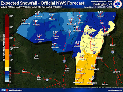
Overall, forecasts have shifted from this morning, given southern and central Vermont a little more snow than earlier forecast. In broad terms, expected snowfall statewide has increased by one to four inches since this morning. 

The winter storm warning, which means at least seven inches of snow is expected, has been expanded northward to encompass Rutland and Windsor counties. 

A winter weather advisory for more or less four to six inches of snow covers the rest of Vermont except Orleans, Franklin, Grand Isle and the western half of Chittenden County. 

In those northwestern Vermont areas, the current forecast calls for one to three inches of new snow. 

It looks like the storm totals in the forecast have been pushed up a bit because this storm really has a lot of moisture to work with. The bulk of the moisture won't make it as far north as Vermont, but the juicy air to the south will really power the moisture enough to dump some pretty heavy snow, at least in southern Vermont. 

If the forecast is accurate, a foot of new snow could grace the slopes of ski areas like Stratton, Mount Snow and Okemo by the time this blows out of here by Monday night. 

Central Vermont ski areas should do OK, too, with a decent six inches or more in many places from Killington to Smugglers. Places like Jay Peak will get some, which is nice, but Jay Peak has been doing a little better with snow than points south, so that's OK.

QUESTION MARKS

Notice I said if the forecast is accurate. 

Tonight's storm has more question marks than usual for a storm that is set to begin within a few hours. Forecasters seem like they really aren't super sure whether the bands of moderate to relatively heavy snow will set up in the southeastern two thirds of Vermont overnight and Monday morning. 

The web site for the National Weather Service in South Burlington has this awesome page that deals with uncertainty levels of winter storms that pass through here. 

The page gives the map of expected snowfall. That's the map I keep posting in almost all the snow storm forecast posts I put up in this here blog thingy. 

A rather ominous, gloomy pre-storm sky late Sunday 
afternoon in St. Albans, Vermont. Here in northwestern'
Vermont, not much snow is forecast, but southern parts
of the state could easily see 6-12 inches by Monday night. 

This page also includes what I call 10 percent maps. These maps offer what the ten percent chances are of a lower end storm or a higher end storm. Put more simply, the maps depict scenarios if the storm turns out to be a real bust and nothingburger, or if it really over-performs. 

The spread among these maps is wider than I usually see when a storm is just about to start. For instance, the main forecast map predicts 10.2 inches of new snow from this storm in Manchester. But the other maps show it could go as low as 6 or as high as 16 inches in Manchester. 

Similarly, the official forecast calls for 5.5 inches of new snow in Montpelier but could go as low as two inches or as high as 10 inches.

The chances of these extremes are low, but not zero.

THE SNOW AND YOU

In any event, if the forecast plays out as expected, snow fall rates would come up to something like one inch per hour, especially south and east of a Rutland to Montpelier to St. Johnsbury line. That's heavy enough to make it hard for Vermont's crack team of snow plow operators to keep up with the storm.

Slippery roads are going to happen state wide during the Monday morning commute, and it will be worse the further south you go. If you have to drive Monday morning, especially in central and southern Vermont, allow a lot of extra time and watch out for the snow idiots on the roads. 

I'm expecting quite a few school closings in southern Vermont with this.

By Monday evening, it will be all over except for some scattered snow showers, and the usual digging out.  

A couple pieces of good news: Unlike so many storms this year, there won't be much in the way of mixed precipitation. 

Since temperatures will be in the upper 20s to around 30, the snow won't be as dry and powdery as you'd expect in a Vermont January. But, it won't be as wet and soggy as we've seen this winter in Vermont. That means if we do see any power outages out of this storm, they will be few and far between. 

THEN WHAT?

Starting yesterday, it's gotten a little colder in Vermont, but it's still warmer than average for the depth of winter. This state of affairs will largely continue this week, though some days will actually be down to average for January.

A cold front Tuesday will throw down a handful of snow showers, or even a brief snow squall or two, especially north, but the accumulations won't amount to much. Wednesday will turn out to be the coldest day of the week, but it will be comfortably in the 20s during the day, 

We're still expected a pretty substantial storm Wednesday and Thursday, but I'm not going to get into it here. 

After that, we stay in an active weather pattern. Storms won't necessarily be big, but there will be frequent moments of us getting a quick slap of light snow. Though the coldest air will stay north in Canada for now, conditions after Thursday feature a greater chance of light snow and a lesser chance of mixed crap. 

It looks like we've finally fallen into a pattern in which Vermont's snow deficit will take some hits. We're still not going to get epic snows, at least for now, but at least some flakes are coming out of the Vermont sky for a change. 

Monday, January 17, 2022

Storm Is Here, Obviously. A Messy Vermont Monday

Monday morning's new snow accumulation map from
NWS Burlington continues to show the Champlain
Valley and Northeast Kingdom "shadowed" from deep
snow accumulations while east facing slopes 
get plastered. Click on th map to make it
bigger and easier to see.
The well-advertised storm is here in Vermont, and you're not going to like your drive into work this morning. If you can work from home, you are lucky.  

Trends continue to give us a slightly more westward tracked, warmer storm, which has implications for this afternoon and evening that you might not like, either. We'll get to that in a bit, but first, this morning. 

The storm has pushed a band of pretty heavy precipitation on its front side all the way up the East Coast and it's in Vermont for the morning commute.

It was snowing at a good clip pretty much everywhere in Vermont a bit before dawn and that will continue into mid-morning for most of us. Precipitation will turn lighter from south to north later this morning. 

Before that, east facing slopes of the Green Mountains are really getting plastered this morning. There was already four inches of new snow in Wallingford, Vermont as of a little before 7 a.m. for instance. Those are the areas that get the most snow, face the worst visibility and the worst driving conditions. I can see six to 10 inches of snow piling up in just a few hours in those areas.

Snow is lighter in the areas "shadowed" from the fire hose of moisture coming from the east. These "shadowed" areas include anything west of the Green Mountains and in the Northeast Kingdom, where the White Mountains are blocking the moisture. 

 Some snow is getting through, though, even if there are some gaps in the snow. Still, it was snowing at a light to moderate pace  in most of the Champlain Valley as of 6 a.m. I saw no reason why that shouldn't continue for a few hours. Roads are snow-covered and slick, of course. Visibility is poor.  You'll definitely need some extra time to get to work. 

The National Weather Service office in South Burlington to me seemed wise to cut expected snow totals in the Champlain Valley a bit to around four or five inches. 

I noticed southeast winds were gusting to 33 mph at the National Weather Service office in South Burlington as of 6 a.m. That was one of the windier place in Vermont and an indication that downslope winds off the west slopes of the Green Mountains were reaching well into the Champlain Valley. (Interestingly, though, winds diminished down to less than 10 mph and shifted to the north temporarily as of 7 a.m. ).

Where downslope winds blow today, accumulations will be less. 

The snow that is falling is getting increasingly wet and heavy as the air warms up. (It was already 32 degrees in Bennington at 6 a.m.)  Winds along the west slopes of the Greens, as noted above, are getting strong.  Winds in some spots could gust to at least 55 mph during the worst of it a little later this morning. 

The snow and the wind make power outages inevitable. The strongest burst of downslope winds were moving south to north in tandem or just behind the band of heavy snow. The strong winds had apparently already reached Bennington County as of 6:30 a.m. as Vermont Outage Map showed at least 1,500 homes and businesses without power there.

The headline to this post mentions the word "messy."  Here's why:  It's going to warm up even more than we thought.  Most valleys in Vermont will reach the mid-30s for a time, with a few spots reaching 40 degrees.  Spotty light rain will accompany this ever-so-brief thaw.

The ground is cold, so any exposed surface, like a plowed back road or sidewalk will ice over. It will be above freezing, but it's been well below zero lately, so the surfaces are cold. So the rain will freeze anyway.

Even worse, as the storm blusters past us, cold air will rush in behind it late this afternoon and evening. Water on the roads will freeze, and get covered by a burst of snow. That leads to a stubborn layer of ice on the roads which will be difficult to clean up.

Temperatures will crash into the single numbers tonight, so things will freeze hard. The snow will taper off, too.

So: Total accumulations look like they will be three to eight inches in Vermont, except six to 12 inches on east facing slopes. There might be local amounts as high as 18 inches in a couple spots in the southern Green Mountains. 

After a cold Tuesday, a weak system will warm us up to 30 degrees with a little light snow. Then it's back into the subzero awfulness for Thursday into the weekend.  At this point, it looks like the Arctic high pressure will keep another nor'easter way off the coast, but who knows? We've been surprised before. 

Sunday, June 20, 2021

Severe Storms Possible Monday In Vermont/Much Of Northeast

 A rapidly developing storm Saturday just north of St. 
Albans, Vermont. The storm raced east and became strong
over northwestern New Hampshire as it encountered a
better atmosphere to sustain itself.
 Saturday was a close miss in terms of severe thunderstorms around Vermont. 

We were just on the western edge of a zone in which storms really fired up Saturday afternoon.  During much of the afternoon, showers would appear in northeastern New York and race across northern Vermont. 

Some of these attempted to form into powerful thunderstorms, but a punch of dry air several thousand feet above the ground prevented them from getting the necessary fuel. 

Strong winds aloft had the potential to be brought down to the surface if these storms really got going, but the higher level winds were so strong that the storms couldn't organize.

You could watch and see how fast these showers would come and go over us. Conditions for bad storms were more favorable over New Hampshire and Maine, so you could track the showers and weak storms zip across Vermont, the blossom into more dangerous stuff in eastern New England.

One such storm grew into a supercell over eastern Maine which prompted tornado warnings. There was wind damage where that storm occurred, so I'm sure that area will be investigated today to see whether a tornado actually touched down 

After a nice summer day, today, there's another chance at severe weather Monday. I'd say that arguably, tomorrow's chances of severe storms in Vermont are highest so far this summer. That's not saying much, but still means we should be on the lookout.

This time, conditions look like they might come together to cause some bad stuff mostly in Vermont and eastern New York, and points southwestward from there. 

Areas in yellow have the best chance of
seeing severe thunderstorms Monday.
A squirt of very warm, humid air will pop up into our neck of the woods tomorrow. It'll be sticky and under some morning and early afternoon, temperatures will get well into the 80s, with a few spot 90 degree readings possible. 

That'll prime the pump for strong thunderstorms by helping create a lot of instability. 

A cold front will be lurking well to our west by afternoon.  As is often the case with potential severe weather threats in Vermont, something called a pre-frontal trough will come in from the west well ahead of the actual cold front. 

A pre-frontal trough is basically a mini-weather front, an elongated area of low pressure where winds converge. Converging winds help encourage updrafts, and that's where thunderstorms can blossom. 

Strong winds aloft can also encourage budding thunderstorms to turn big and nasty,  and that could easily happen tomorrow. The strongest winds high up in the atmosphere will be further west, and not exactly line up with the pre-frontal trough, so this won't be the perfect set up for severe weather. 

But the upper level winds, combined with the instability and plenty of moisture (unlike Saturday),  seem good enough to put us in the risk zone for severe storms Monday afternoon.  

I don't really have the timing down yet, but anytime between, say 1 p.m. and well into the evening will be the time to watch the skies. 

There's a very low, but not zero chance of a 
tornado Monday. The 5% in the map means
there is a 5% chance of a tornado within
25 miles of any spot in the brown part
of the map on Monday. 
The biggest threat from any severe storms Monday, as is usually the case in Vermont, is strong straight line winds. 

Storms might organize into small lines or segments, which could help produce strong winds.  Hail is another threat.  Most of any hail that does form will be small, but there might be pockets of hail that are enough to cause damage.

With the humid air in place, some of these storms could also produce torrential downpours, which could create abrupt street flooding and some gullywashers here and there. 

Since winds will be changing direction with height tomorrow, there's a chance of a rogue supercell or two to form as well. 

NOAA's Storm Prediction Center gives most of Vermont, along with northern New York, northern New Hampshire and western Maine a very low, but not zero chance of a tornado or two with this.  

The actual cold front will arrive Monday night and very early Tuesday. That will encourage plenty of showers and thunderstorms around Monday night. Those later storms probably won't be severe, but could again produce locally heavy downpours. 

That's good news is we can stand the rain, as I keep saying over and over again this dry year. 

I'm sure the severe weather forecast will go through some adjustments between now and tomorrow morning, so we'll update as we get closer to the event.