 |
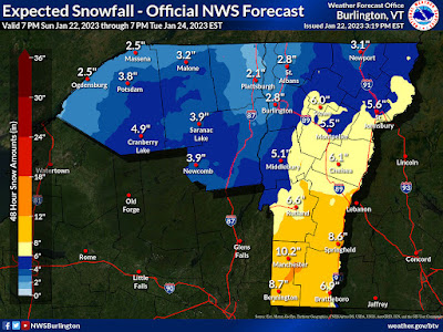
| The Sunday afternoon National Weather Service snow forecast maps have upped expected totals a little bit statewide, but uncertainty surprisingly remains on this. |
ACCUMULATIONS
Overall, forecasts have shifted from this morning, given southern and central Vermont a little more snow than earlier forecast. In broad terms, expected snowfall statewide has increased by one to four inches since this morning.
The winter storm warning, which means at least seven inches of snow is expected, has been expanded northward to encompass Rutland and Windsor counties.
A winter weather advisory for more or less four to six inches of snow covers the rest of Vermont except Orleans, Franklin, Grand Isle and the western half of Chittenden County.
In those northwestern Vermont areas, the current forecast calls for one to three inches of new snow.
It looks like the storm totals in the forecast have been pushed up a bit because this storm really has a lot of moisture to work with. The bulk of the moisture won't make it as far north as Vermont, but the juicy air to the south will really power the moisture enough to dump some pretty heavy snow, at least in southern Vermont.
If the forecast is accurate, a foot of new snow could grace the slopes of ski areas like Stratton, Mount Snow and Okemo by the time this blows out of here by Monday night.
Central Vermont ski areas should do OK, too, with a decent six inches or more in many places from Killington to Smugglers. Places like Jay Peak will get some, which is nice, but Jay Peak has been doing a little better with snow than points south, so that's OK.
QUESTION MARKS
Notice I said if the forecast is accurate.
Tonight's storm has more question marks than usual for a storm that is set to begin within a few hours. Forecasters seem like they really aren't super sure whether the bands of moderate to relatively heavy snow will set up in the southeastern two thirds of Vermont overnight and Monday morning.
The web site for the National Weather Service in South Burlington has this awesome page that deals with uncertainty levels of winter storms that pass through here.
The page gives the map of expected snowfall. That's the map I keep posting in almost all the snow storm forecast posts I put up in this here blog thingy.
This page also includes what I call 10 percent maps. These maps offer what the ten percent chances are of a lower end storm or a higher end storm. Put more simply, the maps depict scenarios if the storm turns out to be a real bust and nothingburger, or if it really over-performs.
The spread among these maps is wider than I usually see when a storm is just about to start. For instance, the main forecast map predicts 10.2 inches of new snow from this storm in Manchester. But the other maps show it could go as low as 6 or as high as 16 inches in Manchester.
Similarly, the official forecast calls for 5.5 inches of new snow in Montpelier but could go as low as two inches or as high as 10 inches.
The chances of these extremes are low, but not zero.
THE SNOW AND YOU
In any event, if the forecast plays out as expected, snow fall rates would come up to something like one inch per hour, especially south and east of a Rutland to Montpelier to St. Johnsbury line. That's heavy enough to make it hard for Vermont's crack team of snow plow operators to keep up with the storm.
Slippery roads are going to happen state wide during the Monday morning commute, and it will be worse the further south you go. If you have to drive Monday morning, especially in central and southern Vermont, allow a lot of extra time and watch out for the snow idiots on the roads.
I'm expecting quite a few school closings in southern Vermont with this.
By Monday evening, it will be all over except for some scattered snow showers, and the usual digging out.
A couple pieces of good news: Unlike so many storms this year, there won't be much in the way of mixed precipitation.
Since temperatures will be in the upper 20s to around 30, the snow won't be as dry and powdery as you'd expect in a Vermont January. But, it won't be as wet and soggy as we've seen this winter in Vermont. That means if we do see any power outages out of this storm, they will be few and far between.
THEN WHAT?
Starting yesterday, it's gotten a little colder in Vermont, but it's still warmer than average for the depth of winter. This state of affairs will largely continue this week, though some days will actually be down to average for January.
A cold front Tuesday will throw down a handful of snow showers, or even a brief snow squall or two, especially north, but the accumulations won't amount to much. Wednesday will turn out to be the coldest day of the week, but it will be comfortably in the 20s during the day,
We're still expected a pretty substantial storm Wednesday and Thursday, but I'm not going to get into it here.
After that, we stay in an active weather pattern. Storms won't necessarily be big, but there will be frequent moments of us getting a quick slap of light snow. Though the coldest air will stay north in Canada for now, conditions after Thursday feature a greater chance of light snow and a lesser chance of mixed crap.
It looks like we've finally fallen into a pattern in which Vermont's snow deficit will take some hits. We're still not going to get epic snows, at least for now, but at least some flakes are coming out of the Vermont sky for a change.


No comments:
Post a Comment