
 |
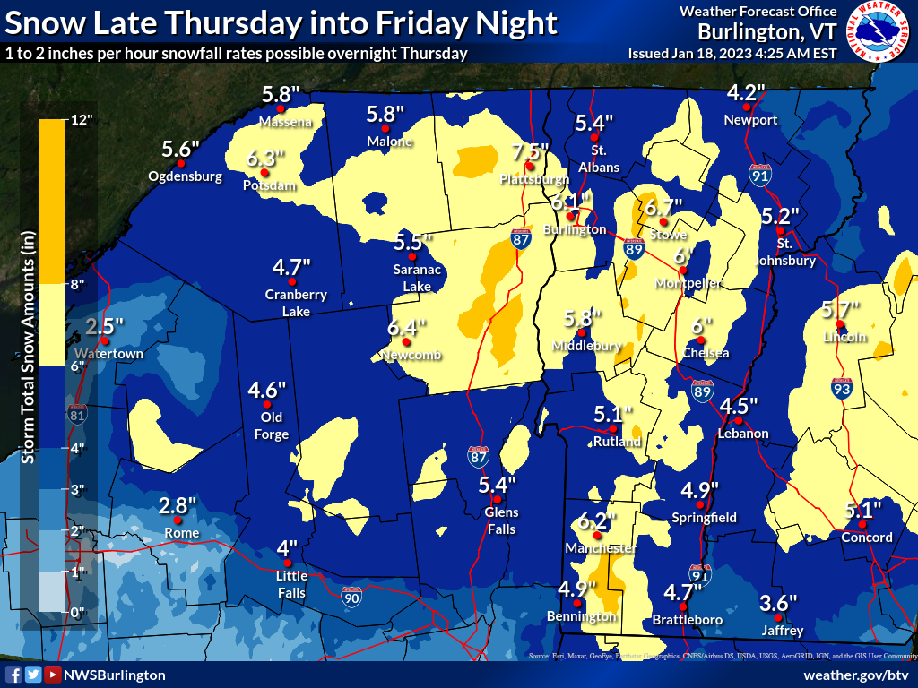
| The snowfall forecast map from the National Weather Service office is back! For now, anyway, they're forecasting mostly a four to seven inch snowfall for Vermont Thursday night and Friday. |
But are we finally setting ourselves up for some real snow? Maybe.
You won't feel that way today in the valleys. It'll be above freezing in most low elevations all day. That'll slightly damage whatever thin snow cover you might have on the ground. A few drops of cold, non-freezing rain are possible, too.
In the mountains, snow showers could leave a dusting of new snow, which is nice.
Then we get into Thursday, Thursday night and Friday, as that mid-sized storm approaching. Meteorologists are still insisting this one will be mostly snow, at least in central and northern Vermont.
The early consensus is we can expect four to seven inches of snow by Friday night, with a bit more than that in the mountains. The National Weather Service in South Burlington decided early this morning to hold off on issuing any winter weather advisories or watches. They did that mostly to not confuse the public with a winter weather advisory for last night's ice. That advisory expired at 7 a.m. today.
I'm all in favor of no confusion, so NWS Burlington is handling this well.
As is often the case, the first part of the upcoming storm is the most "exciting." It'll be an initial thump of fairly heavy snow working its way southwest to northeast across Vermont overnight Thursday.
There is a bust potential in this forecast, especially south, if the initial thump of precipitation brings just a wee bit more warm air along with it than forecast. There isn't all that much cold air for this storm to work with to begin with, so it's easy for warm air to over-perform. We shall see! The further north you go, the better the chances it'll be all snow Thursday night.
 |
| The snow gods might be starting to finally smile on Vermont now. Not a full-fledged big grin, but sort of an uncertain, tentative Mona Lisa smile. |
\This is a double barrel storm. The parent storm, which is laying down a stripe of heavy snow from Colorado to Michigan today and tomorrow will lumber slowly into the eastern Great Lakes. But a spiffy new storm will form in the Mid-Atlantic states later Thursday. That one will zip with pep off the southern New England coast during midday Friday.
That new storm is mostly what's bringing us the initial thump of snow or mix Thursday night. With that storm out of our hair, it clears right up on Friday, correct?
Uh, no. Not this time.
Remember our now, old decrepit storm that caused that snowstorm in the Midwest? It'll still be alive, though arthritic and slow. It looks like it will stagger out of the Great Lakes and limp across northern New England Friday. It'll still be strong enough to continue the light to maybe sometimes moderate snow much of the day on Friday. Since it will have a pocket of slightly colder air aloft with it, this will mostly be snow Friday.
By the way, much of the snow through the whole storm will be relatively wet and heavy. That raises the risk of some power outages. However, it won't be nearly as bad as that big wet snowstorm in mid-December that caused tens of thousands of power outages in Vermont.
It's too soon to tell for sure, but there could be at least two more storms following the one on Friday that could take a track sweet enough to dump snow on Vermont. No promises, but the snow gods might be starting to smile on Vermont. Not a broad grin, but sort of uncertain, tentative Mona Lisa-style smile.
But, if by some miracle we see three moderate snowstorms in a week, which is somewhat possible, the big snow deficit Vermont has built up this winter would be seriously dented.
No comments:
Post a Comment