
 |
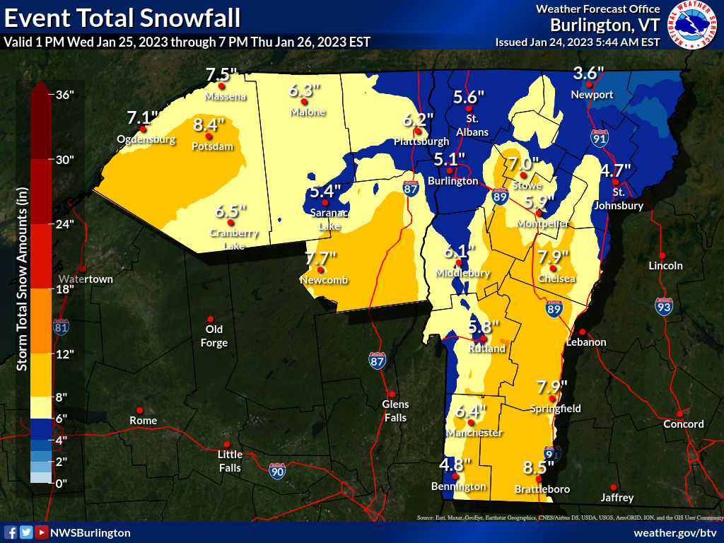
| The last snow forecast map from the National Weather Service in South Burlington. Most of this would come Wednesday night. A decent dump for most. |
This won't be an extreme snowstorm, but for much of the state, it will be another healthy, needed addition to the snow pack.
I noticed many places in Vermont now have a snow cover over 10 inches. That's nothing wild for late January, but it is a little better than what we were doing.
There's actually snow in the air today from a much weaker system. Accumulations will be less than an inch for most of us, but the mountains could pick up a couple to a few inches. Forecasters have backed off on the risk of snow squalls this afternoon, but that risk still looms to some extent. So watch out on the roads.
By the way, one weird Vermont weather factoid I just have to mention. This time of year, the temperatures at Burlington has a daily range of 16 degrees, from a normal low of 12 to an average high of 28. Over the course of two days, Sunday and Monday, the temperature only ranged three degrees, from 28 to 31. Such a narrow range over two consecutive days is extremely rare.
THE STORM ITSELF
The storm that will affect Vermont was organizing in southern Texas this morning. However, I'll focus on Vermont in this post, and get into the dangers other parts for the United States are facing from this dynamic storm in another post later this morning.
It's worth bringing up, as for some people this storm is a bit of a doozy.
For us, as is typical with these storms, a push of warmth and moisture will pour toward Vermont Wednesday night and be forced to go up and over some somewhat colder air near the surface. That'll unleash a burst of pretty heavy snow for most of us Wednesday night.
As always, some places will do better than others. This storm, as mentioned, has some power with it, which means by the time it gets here, it'll have some strong east winds, if not at the surface, then a few thousand feet aloft.
This arrangement focuses the heaviest snow in southern Vermont, away from Bennington, and the eastern slopes of the Green Mountains. Those areas will see at least six inches of snow, probably more. A few places could conceivably approach one foot.
These are the some of the same areas that saw the heaviest snow Monday, so the cover on the ground should get pretty deep along the eastern slopes.
The Green Mountains will block some of the moisture from the Champlain Valley. The White Mountains of New Hampshire will do the same to the Northeast Kingdom. In those places, accumulations will be closer to five inches, or so the current forecasts indicate.
All this is why there's a winter storm watch Wednesday night for southern and much of eastern Vermont, but no advisories yet for the Northeast Kingdom and Champlain Valley.
The warm blast of air overhead will probably be enough to let a bit of freezing rain enter the picture in southeastern Vermont. Some of the warmer valleys in the southeast might go above freezing for a few hours, too, which would cut down accumulations a bit in places like Brattleboro and Guilford and places like that.
The storm will begin to depart Thursday, colder air will be drawn in to change any mix or rain to snow, and that snow will taper off. The western slopes might recoup some of the snow they will have missed out on earlier in the storm as northwest winds will favor continued snow showers there.
We start getting into that long awaited colder pattern after this storm, so anything on the ground should stick around for awhile. Other, weaker little things coming through will give us bits of light snow occasionally into next week. Just to keep the snow cover fresh and clean and white for all of you.
No comments:
Post a Comment