Showing posts with label accumulations. Show all posts

Wednesday, January 8, 2025

Winter Asserts Itself In Southern U.S. .And Up Here In The Great White North

Snow blows off my St. Albans, Vermont roof today as
we continue to get flurried to death under cold,
moist northwest winds. 
Yet another winter storm is gathering forces in the South, likely to lay down another stripe of heavy snow and ice just south of the path of a similar storm a few days ago. 

Meanwhile, up here in Vermont, our "flurries" have amounted to a bonafide snowstorm in a handful of lucky towns, while the ground has at least gotten white most (but not all places) in the state.

Before we get into that, the next big winter storm. 

SOUTHERN STORM

This one promises to stretch from Texas and New Mexico, the plow through parts of Arkansas, in through Tennessee and Kentucky then northern Alabama, Mississippi, and Georgia and finally on to northwestern South Carolina and a decent chunk of North Carolina.

Dallas, Texas could see its first three inch deep snow cover since February, 2021. Raleigh, North Carolina could see its first inch of snow on the ground in three years. 

This follows the first storm Sunday and Monday that left impressive amounts of snow.

Snow totals from the first storm include, 20 inches in Carrollton, Ohio, 19 inches in Thomas, West Virginia, 18 inches in Chapman and Alta Vista, Kansas, 15 inches in Mount City and Weatherby Missouri, 12.5 inches in Bridgeville3, and Milton, Delaware and McHenry, Maryland, 

The southern winter storm will completely miss us here
in Vermont, but our light snow and flurries will
continue to pile up in northern Vermont and
New York mountains for the next couple days 
As of early this afternoon, winter storm warnings extend from around Dallas/Fort Worth on through Arkansas. All this areas can expect three to eight inches of snow, locally more, with some sleet and freezing rain thrown in for some spots.

Winter storm watches extend all the way east to the mountains of North Carolina.  Those watches will probable extend eastward to near the Mid-Atlantic coast eventually. 

On the western end of this storm, things should go down hill tomorrow morning and remain nasty until Friday morning at least. By the time you get to Tennessee and North Carolina, the storm will wait until Friday night and Saturday. 

While it's been awhile since these areas have had snow, this type of thing does happen from time to time. It'll probably end up being all over the news because these southern storms hit areas where people aren't used to it, and they don't have the snow and ice removing equipment we have up here. 

I notice Atlanta is under the winter storm watch Friday and Saturday because they are expecting a boatload of snow and ice. That'll shut down the city, even though they're only expecting a few inches of snow and a glaze of ice. 

NEW ENGLAND/VERMONT

You might have heard rumors this storm would ultimately create a big nor'easter for New England, maybe extending into Vermont.

Ain't happening. 

Traffic cam shows a snowy, cold and desolate looking
stretch of Route 105 in Berkshire early this afternoon.
A minority of computer models did indicate a nor'easter would blow up this weekend and blast across the New England coast. But those were outliers. Everything else indicated the storm would pass out to sea well south of our region.  

That's still very much true. It's going to be a miss, by a wide margin for us in Vermont and other sections of northern New England.

Instead, we're still getting flurried to death.

Between late Sunday night and Tuesday afternoon, most places in Vermont only got an inch or two of snow. 

But the Green Mountains and some of the western slopes got clobbered. More than flurries, that's for sure. 

I saw reports of 10 inches in Waterville, Starksboro and higher elevations in Waterbury, and just shy of 10 inches in Huntington, Underhill/Jericho and Enosburg. 

By my counting, Westfield, not far from Jay Peak, has collected 31 inches of snow since January 1. Jay Peak says they've collected 40 inches of snow in the past week. 

This persistent light snow is surprising motorists. It's cold, and the light snow often packs down under car and truck tires into a barely discernible, thin layer of black ice. It often looks like dry road until you hit the brakes, and then you're in trouble.

Or, roads remained snow covered, as the falling flakes were pretty persistent. The result was plenty of car accidents and slide offs.

After a lull, the snow is picking up again this afternoon, especially across northern Vermont and really, super especially on the mountains. Another wave of deeper moisture is working its way down from Quebec.

The snow will continue well into tomorrow morning most spots. It'll never snow hard, but once again, the northern mountains can expect at least a half foot, maybe a foot by noon tomorrow. 

It's really cold and windy today, too. So for the rest of today and tonight, expect lousy road conditions in much of northern Vermont, snow, blowing snow and a nasty wind chill. Isn't January wonderful?

I anticipate more of the same as the snow picks up in many areas this afternoon and evening. 

Although the snow might diminish for this weekend, it'll stay on the chilly side.  This won't end up being another mild January.  

Monday, December 23, 2024

Vermont Record Above Zero Streak Snaps; Snow Forecast Increases, And Air Pollution Later In Week?

Burlington, Vermont got below zero overnight, ending
a record 663 days of continuously above zero readings.
The record streak of continuously above zero temperatures in Burlington, Vermont finally ended Sunday night. 

Before midnight, it got below zero, ending a 663-day streak that started on February 26 2023.  The previous record longest streak was 654 days between February 22, 2000 and December 9, 2002.

It was obviously cold everywhere around the region.  The usual icebox, Saranac Lake, New York, got down to at least 22 below early today. Lake Eden, Vermont was at 17 below.  Morrisville and Montpelier shared a 10 below reading. 

High temperatures Sunday never got above the single numbers in many areas, setting the stage for the morning's subzero cold.

It was a worrisome night for homeless people in the area, and there are unfortunately many in Vermont. There was no room left at shelters and hotels around the state, according to advocates for the homeless, so they resorted to handing out sleeping bags and other winter gear and hoped for the best. 

A warming center was set up in one Burlington building last night, and volunteers drove around to make unhoused people aware.  I know some people look with distain on the homeless, as some of them are substance abusers and a few of them commit crimes. But as exasperating as shoplifting can get, those who do that sort of thing don't deserve the death penalty by freezing.

If you don't like such frigid weather, you're in luck. This will be the last time it gets below zero at least until we get past New Year's Day.  Highs today will get into the 20s, a decided improvement over Sunday afternoon But wintry weather is going to stay with us for awhile yet.

SNOW INCOMING

Another round of snow is incoming for Vermont and surrounding areas, mostly tonight and early tomorrow.  

Next up, a moderate-sized snowfall mostly tonight, and
focusing on northern Vermont, along with
northern and central New York and northern 
New Hampshire. In Vermont, 4 to 6 inches is likely
along and north of Route 2, with slightly 
lesser amounts to the south. 

It's another Alberta Clipper, one of those usually weak systems that come in from the west or northwest and scoot through with little fanfare.

This one has some real oomph to it, though.  

A winter weather advisory has been issued for northern Vermont, generally along and north of Route 2.  Those winter weather advisories also extend across northern and central New York, northern New Hampshire, parts of Maine, and in most of Wisconsin and Michigan.

So holiday travel is getting screwed up in a several areas. 

Here in Vermont, broad the National Weather Service in South Burlington is telling us most places along and north of Route 2 should see four to six inches of new snow out of this system.  Some isolated areas in the northern mountains could see eight inches. 

Areas between Route 2 and Route 4 look to be in the three to five inch range, and places south of Route 4 are pegged for one to three inches. 

With the snow coming, you might want to think about your Christmas travel plans a bit.

Travel today should be fine. The snow should start between 6 and 8 this evening in northern New York, and reach western Vermont between 8 and 10 p.m. says the National Weather Service. So if you get to where you're going by then, you're golden.

The snow will probably end by midmorning tomorrow in most places. So if you're traveling anywhere on Christmas Eve, try to postpone the trip until late morning or afternoon. 

After that, we should have no snow, ice, schmutz or anything else clogging up Vermont roads from Tuesday afternoon through at least Friday, and probably beyond. But that doesn't end completely end the weirdness

INVERSION/POLLUTION

Starting on Christmas Day and lasting through probably until at least Friday, it is going to get a little odd in Vermont. And in some places, maybe a bit hard to breathe.

I should explain: 

A strong high pressure system is forecast to park itself basically overhead through at least Friday.  The atmosphere overall is expected to warm a great deal.  Except right down near the surface. This time of year, the sun angle is so low it can't heat us up much

If it wants to get warm, we need a south wind to carry the warm air into places we live.  But with light winds under this high pressure, the snow on the ground will just keep the air near the surface refrigerated.

 This creates what is known as a temperature inversion.  Usually, the air is warmest in the lowest elevations and gets progressively colder as you go up hill. 

In an inversion, it's cold in the valleys and warm in the mountains, up a few thousand feet. 

The result will be some warm, even thawing temperatures up at the ski areas, while valleys are stuck in the teens at night, 20s during the day.  There might even be a low overcast, so the valleys are dreary while the mountains are in bright sun.

Inversions happen occasionally in Vermont this time of year, but this one will be more intense and longer lasting than usual. That's a problem.

A problem, because the inversion acts like a lid, trapping pollutants in the valleys.  So all the cars, exhaust for furnaces, wood smoke, etc will get trapped in valleys, possibly causing enough pollution to create issues in people with lung conditions. 

This could happen in the upcoming week in any Vermont valley. But the topography around Rutland is particularly prone to setting up these pollution issues, so that's the region we'll want to watch carefully for pollution this week. 

We're hoping the inversion finally breaks toward the weekend.  

Wednesday, December 18, 2024

Vermont's Iffy Shot At A White Christmas Tonight, Then A Cold Blast

If you don't have snow on the ground now, a storm
later today and tonight gives you the best chance of
a white Christmas. Though it's still iffy in the
Champlain Valley and lowlands of southern 
parts of the state. 
There's still some snow on the ground in much of eastern Vermont and in the high elevations, but lower spots in western and central Vermont are seeing bare ground just a week before Christmas.  

Since so many people are invested in having a traditional White Christmas, will it actually happen?

That's a big maybe.  Depends what happens later today and tonight. 

A modest storm is coming through, passing just to our south tonight. That path would normally put Vermont in the sweet spot for some snow, and for sure, most of us should get some. 

This time, though, there's not a lot of cold air to work with, so things could go either way. 

The storm is coming in a little faster than first thought, which means it'll start this afternoon. When it's warmer.  The higher elevations are fine. It'll snow, and just that'll just add to whatever's on the ground there. 

The valleys, though, will start off as rain.  Plus, it doesn't look like it will cool off all that rapidly as we head into tonight.  Which leaves valley dwellers in communities like Burlington, Middlebury, Rutland, Bennington and Brattleboro are in a race against time.

Will it get cold enough later tonight for it to snow before the moisture from this storm gets whisked away, ending the precipitation?

Said precipitation could come down  hard for a time in south central Vermont. Heavier precipitation tends to cool the atmosphere a little, so those areas stand a better chance of seeing some snow.  No guarantees for those of you on valley floors in Rutland, Castleton, Fair Haven and Clarendon, though.  But you all have a shot of at a couple inches of snow at least. 

The southern and central Champlain Valley seems problematic to me. The National Weather Service hour-by-hour temperature graphic has Burlington's temperature only falling to 34 degrees or so by 3 a.m.  By then, most of the small storm will be leaving the state, so areas close to the lake might get screwed out of snow. 

I think the northern Champlain Valley up by Georgia, St. Albans, Swanton, those sort of place will manage to squeeze out an inch or two of snow. Not sure about the Champlain Islands, though. 

All this said, the National Weather Service forecast - and anybody else's forecast for that matter - has a high bust potential.  If it gets a little colder than forecast, everybody gets at least a couple inches of snow, and more likely a few inches. If it stays a little warmer, more people get rain. 

For now, it looks like most places will clock in with two or three inches of snow, with greater amounts the higher up you go.  Places near Lake Champlain, and the lowest elevations of southwest and southeast Vermont maybe only an inch. Or possibly less. 

Do plan on some tricky driving conditions tonight. The higher you go in elevation, the worse it will get. 

MUCH COLDER

Once temperatures get below freezing later tomorrow morning or afternoon, it will stay below that magical 32 degree reading until Christmas Day afternoon at the earliest. So any snow that does fall will stick. Plus, there's a chance of a little more snow Friday and Saturday, but there would be no more than a dusting in the valleys. The ski areas could pick up a couple additional inches of fluff, though.

Be prepared to shiver Saturday through Monday, as the toughest cold snap of the year so far is still in the cards.  It won't be anything close to record-breaking, but it will feel shockingly chilly given the warmth we've had all year. 

Banana belt towns will see highs in the teens to around 20 and lows close to 0 during this episode. Most of the rest of Vermont gets below zero Saturday and Sunday nights. 

A major and possibly fairly long lasting warm up does look like it wants to start either Christmas afternoon or the day after. That relative balminess could last to the New Year, depending on whether iffy long range forecasts hold.  

Friday, November 29, 2024

Vermont Storm Over, High Elevation Snow Impresses, Lake Effect Leftovers To Add Bit More

Less than an inch of snow at my place in St. Albans,
Vermont, but still wintertime pretty after yesterday's
storm that dumped heavier amounts elsewhere in
the Green Mountain State. 
 The just departed snowstorm in Vermont turned out to be pretty impressive in the high elevations - and a yawner in some of the low spots. 

Totals I've seen so far are 17 inches in Mount Holly, 14 inches in Barnard and Ludlow; 12 inches in Plymouth and West Windsor and 11 inches in West Topsham.

Reports out of West Rutland show just how different higher elevations are from the valleys. A full 10 inches of new snow was measured at a 1,700-foot elevation on a hill above town. 

Then, judging from a convenient traffic camera on the valley floor in West Rutland (where most of the people in town live), it looks like there's only a couple inches of new snow. 

The Champlain Valley was rainy through most of the storm, with just a touch of snow at the end. Burlington reported no measurable snow - just a trace. If no measurable snow falls in Burlington today and tomorrow, this November will tie with five others as the least snowy on record with that trace total.

At my 620-foot elevation in St. Albans, a spot that's a wee bit colder because I'm away from the lake and a little higher, I managed just 0.6 inches. 

Roads in Vermont early this morning were still slick in some areas. Temperatures dipped below freezing in most spots, so any water and slush  left on roads froze. Take it easy heading into town for work or Christmas shopping this morning.

Or better yet, wait until later this morning when most of the roads should be just fine. Still, traffic cameras as of 7:30 a.m. show vast improvements over how things were on the highways during the storm. 

Power outages are still a problem in some areas. The heavy, wet snow brought down power lines and branches throughout the southeastern half of Vermont. 

The outages peaked at around 7:30 p.m. last evening, with roughly 9,400 Vermont homes and businesses without power. As of 6:30 a.m. today, that number had fallen to about 2,500.

This was also easily Vermont's wettest storm since at least late October, so the moisture it's providing will put a little dent in the drought. At least I hope.

Burlington has a solid 0.55 inches of precipitation, almost all rain. Bennington had 0.66 inches of rain and melted snow, so that's not bad. Springfield had a very nice inch of rain and melted snow.

So, with all the inconvenience it caused on the roads and such, this was a perfect early winter storm for Vermont.

The snow focused itself on mountains and ski resorts.  but at least partially spared valleys. That'll make cleanup easier for us valley dwellers, while the resorts can busy themselves grooming trails and giving their cash registers a nice early season workout. 

Even better, there's some ferocious lake effect snows gathering near Lakes Erie and Ontario in western New York (the subject of a separate post soon). The remnants of those lake effect storms will make their way to the Green Mountains over the next two or three days, starting this afternoon.

That means a few ski resorts might get a couple or a few inches of additional snow, while nothing more than light snow and scattered snow showers hit the valleys. 

A long spell of colder than average air is coming in for an extended stay as well, meaning most of whatever snow is on the ground-  especially in mid and high elevations - will stick around. 

Friday, January 5, 2024

Weekend Vermont Snow Forecast Trends Northward Again

The National Weather Service office in South Burlington
has once again nudged expected snow totals upward 
compared to previous forecast. This map was
issued late Friday afternoon
 So far, as of this Thursday evening, forecasters are getting more bullish on snow in Vermont Saturday night and Sunday.   

Once again, the National Weather Service office in South Burlington has bumped up snow accumulation forecasts.

The winter storm watch has been extended northward from its position in Rutland and Windsor counties this morning.  It now encompasses pretty much all of Vermont south of Route 2.

It now also looks like far northern Vermont is in play for a modest two or three inches of new snow, according to current forecasts. That's a boost from the dusting to an inch that was in the forecast yesterday. 

High elevations in far southern Vermont are now under the gun for up to a foot of snow. The winter storm watch has been upgraded to a winter storm warning in Bennington and Windham counties

I don't know whether this northward trend in the storm track will continue right up until the storm hits, but it is encouraging for snow lovers Even if a subsequent storm midweek ends up depositing mixed precipitation or rain.

For the weekend storm, it's looking like the first flakes will come down in the southwest corner of Vermont roughly around 6 p.m. Saturday and spread north to the Northeast Kingdom by around midnight, give or take.

It appears the heaviest snow will come very late Saturday night into Sunday morning. 

Expect snowy, slippery roads and poor visibility later Saturday night and Sunday, especially in central and southern Vermont. 

Of course, we're still more than 24 hours away from the storm, so things can still change either way, with updated forecasts of either more or less snow than I'm talking about this evening.

That expected midweek storm still looks potentially wild, with heavy precipitation and strong winds still possible. I'll do better updates on that storm starting about Sunday, as the Tuesday night/Wednesday storm could end up being on the impressive side.

Quick Friday Morning Vermont Storm Forecast

Latest snow total maps for the weekend storm from
the National Weather Service office in South Burlington
Guided by forecast trends, they've tweaked the 
expected snow totals upwards a notch
compared to earlier forecasts 
 The trends in the computer models as of early Friday morning have been to tick the expected path of this weekend's storm a bit to the north and west of previous forecasts.  

If that trend holds - and that's still definitely an if - that would increase the amount of snow coming to Vermont with this system. 

The official forecast from the National Weather Service office in South Burlington has tweaked snow totals upward slightly from predictions issued Thursday afternoon.  

The new forecasts roughly drop six inches of snow along and south of Route 4; three to five inches between Routes 2 and 4 and one to three inches far north. 

That said, there's still a lot of things that could go right or wrong to either dump much more snow on Vermont or much less. Just slight variations in the storm track would cause a forecast bust.

To illustrate, National Weather Service maps this morning indicate there's a 10 percent chance that the storm could dump a foot of snow as far north as Route 2 and six inches all the way to the Canadian border. On the other hand, there's still a 10 percent chance of absolutely no snow along and north of Route 2 and just two to five inches in southern Vermont. 

The bottom line is: Expect some snow in Vermont Saturday night and Sunday, with increasing amounts the further south you go.  Most of southern New England and interior New York and Pennsylvania are under the gun with likely heavy snow, too. 

As I said last evening, any snow we do get should be fairly powdery, so there shouldn't be any real issues with power outages or anything like that in Vermont. However, the snow could be wetter and heavier down in southern New England and the Hudson Valley of New York, so they could have problems with tree and power line damage. 

SECOND STORM

I'm still more concerned about the second storm expected to hit Tuesday night and Wednesday. First of all, if you like snow, you'll dislike the midweek storm. Things could still change, but right now it looks like a snow to mix to rain event. 

More worrying is the potential for strong, damaging winds in some parts of Vermont with the midweek storm. Again, not a guarantee but something to keep a wary eye on. 


Monday, December 11, 2023

Smaller Than Expected Vermont Storm Nearing End, Power Outages Still An Issue, But Calmer Days Ahead

Sort of a dreamy view of my snowy back yard in St.
Albans, Vermont following today's less than 
extreme snowstorm. 
As of Monday evening, the snow was getting ready to call it quits in northern Vermont and had already pretty much ended in central and southern Vermont. 

That one remaining band of snow could drop another inch of snow on some places north of Route 2 this evening with maybe a couple inches in favored mountain spot. 

THE STORM STATS

The storm mercifully was not nearly as bad as forecasts on Sunday suggested. The storm didn't strengthen as much as expected.

 There was plenty of moisture in the atmosphere for heavy snow, but the relative weakness of the storm meant it couldn't take advantage of all that wetness in the air. 

Nobody got the 18 inches that was hyped for the mountains. Sorry, winter sports fans!

So, we ended up with wet, sticky moderate snowfall. I see a couple reports of 8 or 9 inches of new snow in a couple spots. But northern Vermont mostly reported four to six inches, at least in areas away from Lake Champlain.

One aspect of the storm forecasters got right is the fact that much less snow fell along the shore of Lake Champlain than just a little bit inland. 

I live at a relatively high elevation - 650 or so feet above sea level on the eastern end of St. Albans well away from the lake, and I got a little over five inches. Right along the edge of St. Albans Bay, at a bit over 100 feet above sea level, there was maybe a little over an inch of new snow. 

At the National Weather Service office in South Burlington, only 1.9 inches of snow accumulated as of 5 p.m. That's a lot less than the four to eight inches that some forecasts said. 

This rain and snowfall was a very wet storm, though, by December standards. Most of Vermont had at least an inch of rain and melted snow, with many places definitely exceeding 1.5 inches. There was a bullseye of heavy precipitation in northwestern Vermont. Fletcher reported 2.75 inches of rain and melted snow. St. Albans was close behind with 2.5 inches. 

Burlington received 1.44 inches of precipitation with this storm, bringing the month's to 2.56 inches. Even if not one more snowflake or raindrop lands on Burlington for the rest of December,  the month will still end up just a tiny bit wetter than average. And we're not even halfway through the month yet! 

Since it was an awfully wet snow, power outages were still a problem, despite the relatively modest accumulations. Outages peaked at nearly 8,000 Vermont home and businesses at mid-afternoon Monday. They have been declining since, and we were down to about 4,100 outages as of 5:30 p.m. 

The next hazard with this so-so storm is the return of icy roads in spots tonight. They will mostly wet at sunset, but temperatures will inevitably fall below freezing this evening. That guarantees icy patches, especially on bridges, overpasses, untreated surfaces and back roads. Things won't be nearly as nasty on the roads as this morning, but you'll still need to take care. 

GOING FORWARD

The good news is the rest of the week is looking pretty mellow. It'll be sort of warm tomorrow with highs for most of us in the 30s. A gusty southwest wind will add a bit of a chill to the air, however.

A cold front Tuesday night and early Wednesday will bring some of us a dusting to an inch of snow, with maybe a couple inches in the mountains. No biggie. It'll be seasonable cold Wednesday and Thursday. (Highs 25-35, lows in the teens to around 20).

The overall weather pattern for basically the whole nation has turned warm, and we'll share in that tropical heat. OK, maybe not tropical, but 30s to low 40s for the end of the week and next weekend isn't too shabby for a time of year that can get well below zero.

The next chance of any real precipitation would come Sunday night and Monday.  Current computer models have a storm coming out of the eastern Gulf of Mexico and heading almost due north towards us  Sunday night.

I'm not really buying that scenario and I know for sure the forecast will change quite a bit before we get to that point. So don't worry about it. 


Vermont Storm Messy But Could Have Been Much Worse; Power Outages Still Increasing

National Weather Service forecast map for additional
snow accumulation that is expected to take place after
7 a.m. today. The map is NOT a storm total as it
does not include snow that accumulated before 7 a.m. today.
UPDATE 1 PM MONDAY

As expected, it kept snowing in much of Vermont and accumulations are now quite a bit closer to original estimates.

It won't be as big a storm as we thought this time yesterday, but it's still pretty good.

Snow accumulations here in St. Albans went from 1.8 inches ago 6:30 a.m. to a total of 5 inches as of 12:30 p.m. and it was still snowing lightly.

I see quite a few five to six inch totals cropping up in much of northern Vermont.

I'm sure there will be more complete info later this afternoon.

Power outages have gone up, too. The number was still rising as of 1:30 p.m. and was now up to 7,300 homes and businesses affected .

PREVIOUS DISCUSSION

 I won't say Vermont dodged a bullet this Monday morning, because we didn't. But the bullet is fortunately not quite as powerful as feared.  

The wet snow has materialized, and it's coming down at least moderately at times in much of Vermont before dawn this Monday morning. A winter storm warning remains in effect for good reason

However, it looks like the storm is slightly weaker and taking a track slightly to the east of anticipated, so the effects of this snow might not be super terrible. And not as much will accumulate as I hyped earlier this weekend.

I started to notice the trend toward the weaker/eastern version of the storm with last evening's update, and it looks like that scenario materialized.

Of course, we're still stuck with a terrible morning commute and power outages. The wet snow will continue pretty much until noon or so, and longer than that in the central and northern Green Mountains. 

A number of schools in Vermont are closed or have a delayed opening, so check your local listings.

With somewhat less intense snow in the forecast, power outages won't be quite as widespread as feared. But they're out there, for sure. The outages were just starting to ramp up as of 6 a.m. About Vermont 1,200 homes and businesses were without power at that hour. That's bad, I guess, but not terrible compared to some storms I've seen recently. 

I expect the number of outages to rise this morning as more slushy snow accumulates. 

Despite the fact the storm is somewhat less robust than expected, a decent streak of moderate snow was moving in as of 6 a.m.  That'll hit the power lines to an extent. This heavier snow, relatively speaking, will still hit during this morning's rush hour, as previously advertised. So you'll need to take it slow out there. It'll be an unpleasant drive to work if you're doing that. 

Only 1.8 inches of new snow as of 6:15 a.m. in St. Albans,
Vermont, but it was still snowing. Very wet and sticky; you
can see how it's weighing down the pine trees in the background.

Judging from traffic cams, major highways were slushy as of 6 a.m.  With snow intensities picking up a little, chances are they'll get a little worse, despite the fine efforts of Vermont state plow drivers. 

At least there's less of a chance roads will be blocked by crashes, and fallen trees and power lines. All that is still a risk this morning, but not as big as I was imagining yesterday.

Another benefit of the storm being a little weaker than forecast is winds won't be quite as strong as meteorologists were telling us about yesterday.  

Also, coldish air won't flood in quite as strongly as previously thought. In the warmer valleys remaining light snow might even briefly mix with or change to a cold rain.

So, bottom line: Snow totals: Including what has already fallen will probably amount to three to six inches in the Champlain Valley. A bit less than that will accumulate right next to Lake Champlain. A bit more than the six inches might pile up in the Green Mountain foothills in eastern Chittenden and Franklin counties.

The central and northern Green Mountains should still make out pretty well with this. Some higher towns could end up with a foot or more, but most will get between six and 12 inches. 

Southeastern Vermont valleys will get very little, but higher elevations of the southern Green Mountains, and all but the lowest elevations in Rutland and Bennington counties can expect three to six inches. 

Except for the northern Green Mountains, the snow should be mostly over by mid-afternoon, though a few snow showers will continue in spots into tonight with just a little extra accumulation. Not a big deal.

So, we've gone from an expected candidate for the worst snowstorm of the winter to just a mid-sized mess.  I'll have updates today as warranted

Storms have been extremely challenging to forecast since late November. There's lots of different reasons why, but the main reason is this: Forecasting computer models have gotten good, but they're far from perfect. They don't handle storms that have temperatures near the freezing point well at all. 

With this storm, the National Weather Service in South Burlington indicated in their forecast discussion that the models did not do a good job of figuring out how the severe weather in the South associated with the storm would affect it once it moved north toward New England. 


Wednesday, March 15, 2023

Plenty more clean up to do in my St. Albans, Vermont 
driveway. Forecasts issued Sunday and Monday said we'd 
get about two inches. Instead I have 11.5 inches
of new, heavy snow. 
As we start our Wednesday morning, the snow continues to come down in many parts of Vermont

It's mostly lighter snow, but patches of heavier snow were still around early this morning, especially along the spine and western slopes of the Green Mountains. Even the southern Green Mountains that go so much snow yesterday, still seemed to be getting more as of dawn today. 

WHOPPING ACCUMULATIONS 

Final totals aren't in yet, since it's still snowing in many areas, but the amounts in some areas are absolutely eye-popping. In Vermont, the highest total I've seen so far is 36 inches in Marlboro, followed closely by 34.9 inches in Readsboro.

Those two reports came in last evening.  I'm sure they've had additional accumulations since in those two towns. 

The most I've seen anywhere so far is a crushing 36 inches in Moriah, New York, which is the eastern Adirondack foothills west of Port Henry,  and Colrain, Massachusetts, which is on the Vermont border close to Halifax and Readsboro.  Rowe, Massachusetts was close behind with 35 inches. Plainfield, New Hampshire had 32 inches. 

(There was a report of 43 inches in Beacon, New York, but the National Weather Service office in New York City says that report is erroneous).

Northern and central Vermont definitely over-performed, too.  Preliminary reports give us 23.2 inches in Shrewsbury, 20 inches in Mount Holly, The Addison County town of Waltham had 22.5 inches, which surprised me because it's not a particularly high elevation. (The highest snow totals came from elevated terrain).

Further north in Vermont, so far the highest totals I've seen so far are 22.5 inches in Waterbury Center and 18 inches in Greensboro.   Morrisville was close behind at 17.5 inches. 

We'll see some more, bigger totals later this morning, I'm sure. 

Web cam image from the Vermont Agency of 
Transportation showed traffic tied up in the snow 
along Interstate 89 in Georgia early this morning. 

This storm will join the famous big time, historic snowstorms in Vermont that are clustered around the March 13 and 14 time frame. Those include the Great Blizzard of 1888, a three-foot dump on March 14, 1984, the so-called "Storm of the Century" in 1993 and the Pi Day Blizzard on March 14, 2017.

THE CURRENT SITUATION:

It's still a mess out there in much of Vermont early this morning. About 26,000 homes and businesses were still without power as of 7 a.m. today. That's down from a peak of about 38,000 yesterday, but it's still a lot 

Any falling snow out there is still a little on the wet side as temperatures were near 30 degrees at daybreak.   It's windy out there, and it will stay that way all day. That will cause a few new outages, and make it a lot harder to restore power to those who are already out. 

A lot of schools in Vermont have delayed openings today and a few are closed. More time is needed to clear road of the heavy snow. Power outages, fallen trees and branches are all complicating the cleanup. 

Traffic cameras across the state at dawn today showed main roads in low elevations in southeastern Vermont were pretty good. 

Elsewhere, not so much. Most looks snow covered and slippery as snow continued to fall. Road crews are out, but you're really going to need to take your time heading into work today. Or stay home if you can. Unlike at this time yesterday, roads in the Champlain Valley look worse than highways in other parts of the state. 

I'm also still seeing reports of sections of roads blocked in a few spots in Vermont due to fallen trees and power lines.  I also noticed on a Vermont Agency of Transportation web cam of some sort of traffic jam and stopped traffic on Interstate 89 in Georgia as of 7:45 a.m. today. 

Roads - at least the main ones - should improve quite a bit during the day as snow intensities decline. It'll be a cold one, but plenty warm enough for salt to work on the highways. Plus, unlike yesterday, in most places, the snowfall will be light enough such that some heat from the strong March sun should get through to melt snow and ice on the pavement. 

WHAT'S NEXT

As noted, it was snowing fairly hard in a few locations and steadily in a lot of others as of 7 a.m. today. 

That huge, lumbering nor'easter was still close to the New England coast early this morning, and it was flinging moisture back westward all the way to Vermont and eastern New York.

Trees heavily weighed down by wet snow in my 
St. Albans, Vermont  yard early this morning. 

The storm was expected to be moving east by now, but it's had a hard time moving. Signs are now suggesting that is finally slowly departing, so the snow should taper off gradually. It will probably keep falling at perhaps lighter intensities all day in the mountains and western slopes. 

Winds will gust as high as 40 mph, so where it's a little colder, blowing snow will be a problem today. 

The storm is out of our hair tonight, but no rest for the weary!  A couple of systems will bring us a little bit more snow, then, for most of us, some rain Friday and Friday night. 

The first little thing to come through will be a weak disturbance that will spread snow showers across mostly northern Vermont tomorrow afternoon. That snow will probably mix with rain in the warmer, lower valleys. 

Anybody that does get snow from this won't see much. Maybe an inch or two.

On Friday a somewhat stronger storm comes through. with mostly rain, though some snow will come at the beginning and end of it, especially in the mountains and the Northeast Kingdom.

We won't see enough rain to cause any widespread flooding but there could be some problems in towns and cities where rain and melting snow will sit and cause street flooding because storm drains are clogged with snowbanks. 

Behind that storm, we'll have a really cold day on Sunday with a few snow showers around (Highs will only be about 30 degrees, which is at least ten degrees colder than normal for this time of year).

However, it's beginning to look like we start next week with great sugaring weather. Hard freezes will come at night as temperatures go into the low 20s, but afternoons will pop up to the low 40s for many of us. Sunshine should help, too.

Those of you who want to play in the snow over the next few days certainly have plenty of it. Just watch it in steep back country areas. I'd say there's a pretty good avalanche risk up there. 


Tuesday, January 24, 2023

Next Big Thump Of Snow In Vermont Later Wednesday

The last snow forecast map from the National
Weather Service in South Burlington. Most of this
would come Wednesday night. A decent dump for most.
While southern Vermont finishes cleaning up from Monday's snowstorm, meteorologists are busily monitoring the next dump of snow on the Green Mountain State. That dump should come mostly later Wednesday afternoon and Wednesday night. 

This won't be an extreme snowstorm, but for much of the state, it will be another healthy, needed addition to the snow pack.

I noticed many places in Vermont now have a snow cover over 10 inches. That's nothing wild for late January, but it is a little better than what we were doing. 

There's actually snow in the air today from a much weaker system.  Accumulations will be less than an inch for most of us, but the mountains could pick up a couple to a few inches. Forecasters have backed off on the risk of snow squalls this afternoon, but that risk still looms to some extent. So watch out on the roads. 

By the way, one weird Vermont weather factoid I just have to mention. This time of year, the temperatures at Burlington has a daily range of 16 degrees, from a normal low of 12 to an average high of 28. Over the course of two days, Sunday and Monday, the temperature only ranged three degrees, from 28 to 31. Such a narrow range over two consecutive days is extremely rare.  

THE STORM ITSELF

The storm that will affect Vermont was organizing in southern Texas this morning. However, I'll focus on Vermont in this post, and get into the dangers other parts for the United States are facing from this dynamic storm in another post later this morning. 

It's worth bringing up, as for some people this storm is a bit of a doozy.

For us, as is typical with these storms, a push of warmth and moisture will pour toward Vermont Wednesday night and be forced to go up and over some somewhat colder air near the surface. That'll unleash a burst of pretty heavy snow for most of us Wednesday night. 

As always, some places will do better than others. This storm, as mentioned, has some power with it, which means by the time it gets here, it'll have some strong east winds, if not at the surface, then a few thousand feet aloft. 

This arrangement focuses the heaviest snow in southern Vermont, away from Bennington, and the eastern slopes of the Green Mountains. Those areas will see at least six inches of snow, probably more. A few places could conceivably approach one foot. 

These are the some of the same areas that saw the heaviest snow Monday, so the cover on the ground should get pretty deep along the eastern slopes. 

The Green Mountains will block some of the moisture from the Champlain Valley. The White Mountains of New Hampshire will do the same to the Northeast Kingdom. In those places, accumulations will be closer to five inches, or so the current forecasts indicate.

All this is why there's a winter storm watch Wednesday night for southern and much of eastern Vermont, but no advisories yet for the Northeast Kingdom and Champlain Valley. 

The warm blast of air overhead will probably be enough to let a bit of freezing rain enter the picture in southeastern Vermont. Some of the warmer valleys in the southeast might go above freezing for a few hours, too, which would cut down accumulations a bit in places like Brattleboro and Guilford and places like that. 

The storm will begin to depart Thursday, colder air will be drawn in to change any mix or rain to snow, and that snow will taper off. The western slopes might recoup some of the snow they will have missed out on earlier in the storm as northwest winds will favor continued snow showers there. 

We start getting into that long awaited colder pattern after this storm, so anything on the ground should stick around for awhile. Other, weaker little things coming through will give us bits of light snow occasionally into next week. Just to keep the snow cover fresh and clean and white for all of you. 

Wednesday, January 18, 2023

Wednesday Evening Storm Update: A "Meh" Storm, But At Least Vermont Gets Some Snow

Total snowfall predictions from the National Weather 
Service office in South Burlington are down from this
morning's expectations. Also, pardon the sloppiness
of this image. I just bought a new MacBook Air, 
which is great, but the new MacBooks are 
extremely hostile to cropping screen grabs.
 At least for now, forecasters are backing off a bit on expected snow totals from the upcoming storm in Vermont Thursday night and Friday. 

Still, we'll end up with more snow on the ground than we have now. For snow lovers, that's good considering the snow drought we're experiencing so far this winter. 

Since there's still not a lot of cold air to play with, this will be a fairly wet snowfall, and a mix of precipitation will probably work in to this mess, especially in southern Vermont. 

Though I'm not a full-fledged meteorologist and am definitely not up to par with the experts at the National Weather Service office in South Burlington, I have to agree with them that the initial thump of snow or mix Thursday night might under-perform. 

Freezing rain or sleet can mix in, more so the further south you go. Still, snow could come down kind of heavy at times, so travel Thursday night and early Friday could definitely be tricky.

Best guess is the eastern slopes of the south-central Green Mountains (think Mount Holly, Ludlow, Shrewsbury and Killington) will do best with the initial thump of snow. The places that will do worst, in terms of snow accumulation in the first phase of the storm, are valleys in southwest and southeast Vermont due to mixed precipitation. Also, the western slopes of the Green Mountains further north might not do great either. 

At this point, it looks like there might be a lull in precipitation Friday morning. This could be in the form of an ugly freezing drizzle in much of Vermont for awhile during the first half of Friday. 

Then, as an upper level low comes across northern New England during the day Friday, the freezing drizzle is expected to disappear in favor of more snow. It won't snow hard during the day Friday, but it could mess up travel.

For now, the National Weather Service in South Burlington has issued a winter weather advisory for areas of Vermont outside the Champlain Valley. In these areas, a decent snowfall of four to six inches of snow is still in the forecast, with maybe a bit more in some of the mountains.

In the Champlain Valley, the forecast, as of Wednesday evening, has the snow coming in too slow and too light to qualify for a winter weather advisory, but the snow will probably be enough late Thursday through Friday to make you want to take care on the roads. 

As I noted, there's not a lot of cold air available, so the snow will be fairly wet.  Expect a few power outages state wide, but this continues to look like it won't be an extreme event. Which is excellent. 

Note that this forecast can, and probably will change before we get to the event. Stay tuned for updates! 

Also, there seems to be a good chance of more possibly snowstorms on Sunday night and Monday, and the middle of next week. It's too soon to deal with those, so we'll just concentrate on this upcoming storm Thursday night and Friday.


Saturday, December 17, 2022

45,800 Vermonters Without Power In Escalating Soggy Snowstorm

Snow-laden trees look ghostly in the pre-dawn darkness
Saturday morning in St. Albans, Vermont. Wet snow
has cut power to nearly 46,000 Vermont customers 
as of 5:30 a.m. 
 I'm doing a very early Saturday morning update to get this out in case my power fails.  If my power does not fail, I'll fill in the details later this  morning. 

The reason why I'm saying this is that it almost seems like everybody in Vermont is losing power as the wet, heavy snow continues overnight and early this morning. Nearly 46,000 homes and businesses were without power as of 5:30 a.m. and that number was continuing to rise as the snow continued.

The power outages are now statewide, instead of being just limited to southern Vermont. Forecasts of heavier snow in northern Vermont came true, so there's branches, trees and wires falling all over the place. 

It's dangerous to be out driving, especially on rural roads. Not only is there deep snow and ice on the roads, trees and live wires are falling across them in some areas. Stay home this Saturday morning. 

Not all that much additional snow will fall in the valleys today, maybe one to three inches, but the damage is done. It will take quite a lot of time to restore power to everybody, given the scope of the problem.  This is likely the most damaging snowstorm in Vermont since December, 2014 when another big, wet, soggy storm cut power to 100,000 customers in Green Mountain State.

Even when the snow drops back to light snow and flurries, new power outages will probably crop up all day.  In the valleys, temperatures will climb into the mid-30s.  This will cause trees to shed their heavy snow loads. Branches will pop up back into place, possibly shearing wires off poles in the process.

We obviously don't have complete snow totals yet, but the few reports we have our impressive. They include 20.2 inches in Shrewsbury, 17 inches in Pomfret, 15.3 inches in Greensboro and 15 inches in St. Johnsbury.

If the power stays on (fingers crossed!) I'll update this post with more information a bit later this morning. 


Saturday, March 12, 2022

Storm Winding Down For Most Of Vermont, But Blowing Snow, Gusty Winds Remain An Issue Overnight

A snowy March day in St. Albans, Vermont today means
the garden tools in my shed will need to stay in there
a bit longer before spring hits. 
 Snowfall amounts with today's storm are coming in near, or in some places just a little below forecasts  so far, as today's storm lacked the drama that forecasts had feared a few days ago. At least here in Vermont. 

As of late afternoon, snow totals were in the four to nine inch range across most of central and northern Vermont. Most places were in for another inch or or two of snow.  It was still snowing at a pretty good clip in eastern Vermont as of 5 p.m., so they might receive up to three inches of new snow.

Right along the shores of Lake Champlain, it looks like accumulations are lackluster.  It's hard to judge from webcams, but it looks like there's only about three or four inches of new snow in Alburgh. The WCAX web cam right along the lake shore in Burlington also seemed to show just a few inches, and actually showed a bit of clearing in the skies to the distant west as of 5 p.m.

Snow piled up more rapidly just inland from the lake, along and east of Route 7.   The National Weather Service office in South Burlington reported 7.2 inches of new snow by late afternoon. At my place in St. Albans, I was on the low end of the accumulations for once, with 5 inches.

But my place in eastern St. Albans is prone to a little upslope snow, so I expect perhaps, another inch or two of snow overnight.  But then again, I could see a bit of clearing in the skies past the Adirondacks, so maybe not

Tonight's weather setup is pretty good for decent upslope snows closer to the western slopes and summits of the central and northern Green mountains. 

That means some of those western slope towns will come in with reports of a foot or more of snow by morning. That would make the pre-storm forecasts essentially right. 

The WCAX/ECHO Web Cam on Burlington's waterfront 
actually showed a bit of clearing in the distant west
late Saturday afternoon as today's storm was a little
milder in some areas than forecasted. Still. the 
snow predictions issued before the storm will 
end up being close to reality.
As of late afternoon, there were only a handful of power outages in Vermont - less than 100 - as the wet, sticky phase of the snowfall in most areas today was pretty short lived. It wasn't enough to cave in a lot of trees and power lines.  

Winds were increasing by dusk today, but gusts were still in the reasonable 20 to 30 mph range. They'll increase further overnight with gusts of 40 mph or so.  

That could trigger just a few isolated to scattered outages, what with the wet snow now frozen onto the trees.  Still, the winds don't seem to be shaping up as anything as fierce as first expected

Road conditions weren't great all day, and will stay not great all night.  It's not impossible to get around out there, but it still isn't worth it to go anywhere unless you really have to.

All in all, it's shaping up to be a somewhat tamer storm that forecast, at least so far.  Western slope snow and wind gusts are still a bit of a wildcard over night. Blowing snow is going to be a problem all night. But it all could have been worse.

The forecast for the next few days is higher confidence than the predictions for our departing storm.

It will still be blustery and chilly Sunday with highs only in the 20s.  The sun will come out, though, at least part of the time. 

We're still looking at warmer weather through most of the week.  Tuesday will be the coolest, with highs only in the 35 to 42 degree range, which is about normal. Monday will in the low 40s, Wednesday in the upper 40s and Thursday in the low 50s.

Long range forecasts are now arguing about Friday. It will be warm, unless it's not, frankly. Some models have highs that day in the 50s, others in the low 30s. Take your pick! 

Saturday, February 26, 2022

Snowstorm Cleanup Today. Next Up, Of Course, More Wind, Snow Squalls

Vermont Agency of Transportation web cam along snowy
Route 78 in Alburgh at dawn today. You can see a little
sea smoke from Lake Champlain in the background
I could hear the snow plows cleaning up around St. Albans, Vermont as dawn broke after yesterday's snowstorm.  

If you're on your way to the ski slopes this morning, do keep in mind we're starting off cold with pretty much everybody in Vermont within a few degrees either side of 0 degrees.

 So, salt isn't working great on the roads to start the day.  The black ice that caused some big crashes yesterday is still there. 

As the sun comes up and temperatures rise into the 20s this afternoon, road conditions will improve nicely. For now. More on that in minute.

SNOW TOTALS

Final snow totals are coming in. The big winners seem to be in parts of Washington and Orange counties, where many places were at or near a foot of new snow. The most I've seen so far is 13.2 inches in high elevation East Barre and a foot at Moretown.  

The northern Champlain Valley did well, too. My total in St. Albans worked out to an even 10 inches. Since the snow was super light and fluffy that 10 inches had compacted down to eight inches by this morning.

The big losers, if you will, were in southern Vermont, where less snow fell than expected.  Shrewsbury, usually a high elevation snow belt town in eastern Rutland County had a middling 6.5 inches. In Vermont's two southernmost counties, where some favored places were expecting at least a foot of snow, the most I saw was 9.3 inches in Brattleboro.

High elevation southern Vermont towns that often score big with snowstorms, like Woodford, Winhall, Readsboro and Athens, picked up six to 8.5 inches of snow. Decent, but not wild.

We're still behind normal for snowfall this winter, despite a February that for most of the state was a bit snowier than average.

For the season, Burlington now has 55.5 inches of the snow for the season to date.  That's 8.3 inches less than normal for this point in the winter. 

CRASHES

A blue dawn in St. Albans, Vermont this morning
with the fresh snowy reflecting the 
deep blue sky overhead

Also as noted yesterday, there seemed to be more highway crashes than usual for a Vermont snowstorm, especially one that lacked sleet or freezing rain.  Part of it was overconfidence among motorists who are "used to" driving in the snow. 

Another big part was the temperatures. Readings stayed mostly in the teens all day.  It was a cold storm, one too cold for salt to work very well. 

Plus, at the height of the storm, snow was accumulating faster than plow crews could handle.  No fault of the plow drivers, but snowfall rates of one to two inches an hour are not something you can get on top of.

The worst crash was that Interstate 89 pileup Friday afternoon northbound in Milton. This was one of the biggest and worst pileups I can remember in Vermont.  One person died, and a few others had non life threatening injuries. At least 30 vehicles were involved, and the northbound lanes of the Interstate were shut down for something like seven hours. That caused a lot of traffic disruptions during the snowy afternoon commute in much of Chittenden County. 

We had reports of several other crashes and road closures throughout Vermont Friday.  One rollover crash happened right in front of my house in St. Albans. The driver was not seriously injured.

We have more snow and hazardous travel worries on Sunday. 

WIND AND SQUALLS

As noted, today is going to be a gorgeous, if somewhat chilly day for late February, but things go south again Sunday. 

Gusty winds will keep increasing starting overnight actually and getting stronger as Sunday morning wears on. The new snow is incredibly powdery with a low water content, which means it will blow around super easily. 

Winds could gust as high as 40 mph in the Champlain Valley by early afternoon, if not before.  Exposed areas will have whiteout conditions in the blowing snow.

Speaking of whiteouts, snow squalls are still in the forecast for Sunday afternoon and evening.  Another sharp cold front will be diving in from the northwest.  It has enough energy with it to create some pretty powerful snow squalls as it comes through. 

Those squalls can be instantly blinding on the roads, and they are arguably the most dangerous kind of winter weather hazard out there. At least for motorists. The initial snowflakes with the squalls might melt on contact with the road, but then quickly freeze, adding a layer of black ice to the whiteout conditions. 

Black and white. Not good when you're talking about driving around in the winter. 

Strong northwest winds Sunday night will also keep the snow blowing around. Since the winds will be out of a different direction than the morning's gusts, it'll be that much easier for snow to blow around and drift. 

NEXT WEEK

We're getting into the first week of March, and as you know, that month can either be springlike or very wintry.

It looks like Vermont is taking the wintry option for the opening days of March.  It should remain solidly below freezing all week, at a time of year when temperatures often poke upward at least into the mid-30s. 

It doesn't look like there will be any big storms. A little thing coming through Tuesday night or Wednesday will probably lay down a dusting of snow, but it won't be a big deal. The next shot of any snow, rain, ice or schmutz looks like it might come along a little over a week from now. 


Friday, February 4, 2022

Vermont Snow Deepens, Ice Finally Leaving Northeast

As you can see, roads were still snow covered in most
of Vermont by late morning. This is Fairfield Hill
Road (Route 36) in St. Albans, Vermont
 A quick early afternoon update for our storm. 

Snow has lightened up across most of Vermont, and only light snow will continue the rest of the day. Further accumulations will run in the one to four inch range for most of us. 

The wave of low pressure  that kept southern New England warm - way up in the 50s - and central New England mired in freezing rain and sleet, is departing to the east.

This departure allowed cold air to rapidly sink south through the rest of the Northeast, and bring a few hours sleet and freezing rain to southern New England.

The change in temperature in many areas was abrupt. At one point this morning, temperatures in New York City were all over the place because of the front. It was 36 degrees in the Bronx, while 10 miles south it was 58 degrees in Central Park. 

As the day goes by, all of the Northeast will just get cold.

The flood of cold air on the back side of this system means anyone in Vermont receiving precipitation today will have snow. Including in the ice storm zone in far southern Vermont. 

Power outages there are slowly being repaired, though gusty winds are causing a few new issues. Early today, about 5,600 customers were without power. By noon, it was down to around 4,300.

Here in Vermont, snow amounts have been going up nicely. As of late morning, it seems around a foot of snow was a popular amount for almost everyone from Rutland and Windsor counties north to the Canadian border. 

The most I've seen any one place get so far is 14.5 inches in Braintree.  The snowfall has gotten even fluffier for the afternoon.  That means snow totals will go up by a few inches, but there's not much added water content in the snow

Temperatures will stay within a few degrees of 10 for the rest of the day. That means salt won't work great on the roads, and additional light snow will keep conditions tricky. 

Enjoy the powder, everyone!  Sorry about the ice in southern Vermont, but hopefully you'll get your chance at a nice dump sometimes this month or next! 

Monday, January 17, 2022

Monday Evening Update: Surprisingly Pleasant Vermont Winter Storm, At Least For Some Of Us

A truck got stuck on icy Fairfield Hill Road (Route 36)
during Monday's storm, tying up traffic for about a 
half hour. Somebody came to their aid, plowing
in front of the truck and spreading salt. 
For all the misery today's winter storm caused in the eastern United States and southeastern Canada, tbis one turned out to be a surprisingly pleasant one, all things considered. 

Strong downslope winds this morning did cause some damage to trees and power lines along some of the western slopes of the Green Mountains, especially in southern Vermont. I got a report today of shingles blown off at least one house on the Mendon/Rutland border. 

That strong east wind aloft did initially dramatically cut down on snowfall in western Vermont and in the Northeast Kingdom. 

But a second, several hours long batch of snow moving southeast to northwest across Vermont this afternoon made up for that. In some places, and then some.  Some Northeast Kingdom towns reported only a half inch of snow with the first batch of snow this morning, but came in with storm totals of four or five inches.

Burlington managed 6.3 inches so far, and my place in St. Albans received 5.4 inches. That second bath of snow was able to produce in what had been those drier downslope areas because the winds that had been roaring out of the east a few thousand feet overhead had greatly diminished by late morning. 

The lack of strong east winds mostly erased the "shadow" along western slopes, and snow was able to accumulate. 

The biggest snow totals I've seen so far in Vermont include 14 inches in Wilmington, 13 inches in Northfield and Rochester, and 12 inches in Waitsfield. I'm sure a few other reports will go higher, especially since some light snow will continue, especially in higher elevations through this evening. 

The big loser in the snow department is probably Bennington. Webcam images showed very little snow on the ground there this afternoon, and temperatures were in the upper 30s for a time. 

It did manage to get into the mid-30s in valleys of Vermont away from the Champlain Valley, which stayed a little cooler. But very little rain fell, which was nice. 

The warmth in far southern Vermont valleys left roads in pretty good shape there. The sun even broke through in parts of southern Vermont. 

Roads remain in relatively bad shape in much of northern Vermont. Along my road, Route 36 (Fairfield Hill Road) in St. Albans, a truck got stuck on the steep slope, blocking traffic for about a half hour late this afternoon.

Those comfortable temperatures from this afternoon will be swept away by cold northwest winds tonight. It'll get down into the single digits, with wind chills below zero. It will barely make into the low teens Tuesday.

After a brief warmup with light snow Wednesday, it's back into the deep freeze again.

You really want snow to build up in the winter on the ground in Vermont, to get spring off to a wet start and recharge groundwater.

This storm helped some, but we're still well behind in both snowfall and precipitation overall so far this month. Unfortunately, it looks like we're reverting back to a colder and drier than normal pattern through at least the end of January. 

HAVOC ELSEWHERE

This storm was decidedly less picturesque and fun elsewhere on its long trek through much of the United States and southeastern Canada. On Sunday, the heavy snow and ice caused no fewer than 630 crashes on North Carolina highways. Two people died when a car slid off Interstate 95 in North Carolina and hit trees.

The storm cut power along its tracks all the way from Georgia into southern Quebec.  At least 215,000 were without power up and down the East Coast as of late morning, according to CNN.  There's lots of tree and wire damage from the ice in parts of the Carolinas, and that will take time to fix.

The storm contributed to about 3,000 canceled flights Sunday and at least 1,200 cancelations today 

The storm produced coastal flooding and prompted some evacuations in Connecticut along Long Island Sound. 

The storm's heaviest band of snow was well west of its center, hitting near the Ohio/Pennsylvania border, on up through western New York and then to Toronto and Ottawa

Ashtabula, Ohio reported 27 inches of new snow and Erie, Pennsylvania clocked in with 20.3 inches.

Ottawa, Canada reported 17 inches of snow, its second largest snowstorm on record. A whopping 4.7 inches of that came down in just one hour. Toronto was under a blizzard warning earlier today and accumulated at least a foot of snow.

Up in Quebec City,winds roared at speeds of up to 55 mph, causing blizzard conditions up there.


Wednesday, November 24, 2021

Update: First Friday/Saturday Snow Accumulation Forecasts

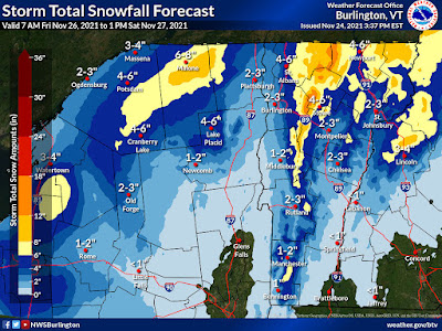
The National Weather Service in South Burlington this 
afternoon took their first crack at expected snowfall Friday
through Saturday. Yellow areas can expect at least six
inches. High elevation spots in darker orange could
get a foot or more. 
It's beginning to look like the spine of Vermont's  Green Mountains, and to some extent the western slopes of the Greens, the Northeast Kingdom and perhaps the northern Champlain Valley are in for a pretty good snowfall, especially Friday night and Saturday.  

The ingredients are still coming together for an upslope snow event. That's when winds are forced to glide up the western slopes of the Green Mountains, combined with lots of moisture wrapping around a storm to our northeast, will unleash a lot of snow. 

The thinking from the National Weather Service in South Burlington is that the spine of the Green Mountains from about the Sugarbush resort in Warren on north through Mount Mansfield and Jay Peak are in for a good 12 to 18 inch dump.

The western slopes - towns like Lincoln, Huntington, Underhill, Jeffersonville, Bakersfield and Montgomery might get a good six to 10 inches of snow. 

The Northeast Kingdom and perhaps the northern Champlain Valley away from the immediate shore of Lake Champlain could easily get four or five inches of snow out of this as well. 

If you're around the Burlington area, at this point it looks like you're going to see quite a gradient of snow accumulation. At Burlington's Waterfront Park, they'll probably barely manage a dusting to an inch. By the time you get out to Williston, we're talking about a possible four or five inches, if things work out as they now appear.

Note that forecasts can change. This is just an early read on the situation. 

Anyone who does get a lot of snow will see it stick around for quite awhile. It will stay too cold for any substantial melting at least through next Wednesday.