
Showing posts with label Atlanta. Show all posts

Saturday, January 11, 2025

Southerners Weather Winter Storm Better Than In Past Snow/Ice Crises; Northern System Doesn't "Cooperate" So No Nor'easter

National Weather Service map from Thursday. That
huge area of pink in the South was winter storm warnings.
You'd expect a major crisis with that much of the 
South under a winter storm. While the storm proved
disruptive, it was not nearly as chaotic as 
previous, similar-sized southern winter storms. 
That big Winter Storm #2 of the past week just performed as expected Friday, spreading snow and ice from Texas to Georgia and Virginia, but one aspect of this storm did not follow the script. 

The South usually goes into a panic mode and grinds to a halt when it snows or freezes.  There's gridlock on the roads, people are stranded for hours or days, the power goes and out and people freeze in the dark  and it's a huge mess.

All that sort of thing happened, a little bit, but a funny thing happened on the way to the storm. 

For the most part, warnings were heeded, people stayed off the roads, and schools and businesses shut down everywhere. 

That kept most people indoors, and out of danger. People were actually having fun.  If you counted snowmen as people, the population of the South probably would have doubled on Friday. 

The South is not having a weather crisis. 

Part of it is the fact that there really hasn't been a widespread winter storm in the South for two or three years now. So when this one finally hit, people had the proper fear of God and prepared - and stayed home. 

I also think lessons have been learned from previous storms. 

For instance, Atlantans are still gun shy from a 2014 winter storm that stranded thousands of Atlanta area workers and students at their office and schools overnight. 

This time, pretty much everybody who could canceled classes and closed offices, asking people to work from home if possible. 

The 2014 storm gridlocked Atlanta because instead of just canceling things before the storm arrived,  everybody was sent home during the storm at once into three inches of new snow, which was more than enough to thoroughly screw up a southern city. 

This time, things were much more relaxed. That's not to say the current storm didn't mess things up at all. 

Hartsfied-Jackson airport in Atlanta, the nation's busiest, went through two ground stops Friday, meaning planes at those times could not take off from or land at the airport. nearly 1,200 flights were canceled. 

It started as snow in Atlanta, with more than three inches reported, but then during the day, things changed to an uglier freezing rain. 
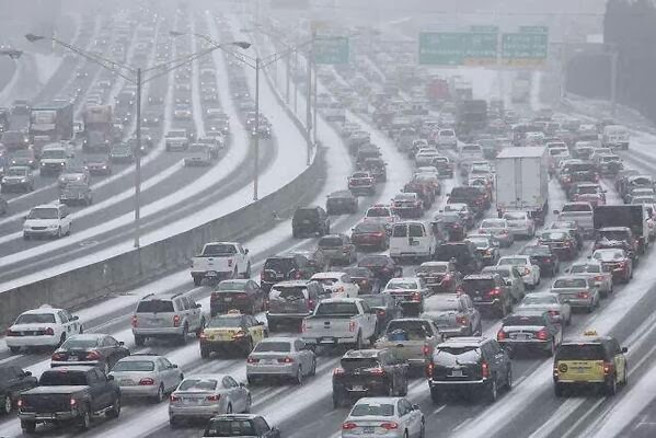
The chaos in Atlanta during the January, 2014 winter
storm. The one that hit Friday was disruptive, but
did not cause a crisis like the one more than a 
decade ago did. 

Because ice was in the mix along the entire path of the storm, at least 75,000 power outages were reported Friday, mostly in Texas, Arkansas and Mississippi

Cars and trucks were indeed stranded on the roads across the South, but it fell well short of a critical mass. There weren't thousands of people stuck in cold cars on frozen interstates all night. 

The snow was pretty substantial in spots. A few reports of a foot of snow came in from Arkansas.  Little Rock reported a little under 10 inches so snow, a city that averages roughly 4 inches per year.

Parts of South Carolina had wintry weather for the first time in three years. 

Up in North Carolina, they canceled an outdoor inauguration ceremony for new Gov. Josh Stein and other elected officials.

WHY NORTHEAST MISSED OUT

The storm causing the mess in the South is scooting out to sea along the North Carolina coast this morning and eventually become a really powerful storm Sunday well southeast of the Canadian Maritimes. 

Though it's not happening in this go around, Sometimes, this type of storm southern storm comes roaring up the East Coast as a big boisterous nor'easter. 

In order for that to happen, you usually need the cooperation of a weaker northern storm. 

It's called "phasing." That weaker northern storm positions itself roughly due north of the southern storm. That arrangement draws the southern storm up the East Coast. Often the northern and southern systems will merge in the Northeast to become that big ass nor'easter. 

This time, our weak northern storm lagged a little bit. While the southern storm moves off the North Carolina coast, the northern little guy is just getting around to coming off the Great Lakes toward the New England.

The two storms didn't line up properly. They didn't communicate, they didn't line up property. If this were an office, I think the boss would have a word regarding this. 

In any event, the weak northern thing comes through Vermont today, depositing a light inch or two of snow before moving on and being forgotten.

Then, we're left with another upcoming week of seasonably cold temperatures and occasional chances of light snow and flurries. The quiet, chilly January of 2025 continues in New England.  

Wednesday, January 8, 2025

Winter Asserts Itself In Southern U.S. .And Up Here In The Great White North

Snow blows off my St. Albans, Vermont roof today as
we continue to get flurried to death under cold,
moist northwest winds. 
Yet another winter storm is gathering forces in the South, likely to lay down another stripe of heavy snow and ice just south of the path of a similar storm a few days ago. 

Meanwhile, up here in Vermont, our "flurries" have amounted to a bonafide snowstorm in a handful of lucky towns, while the ground has at least gotten white most (but not all places) in the state.

Before we get into that, the next big winter storm. 

SOUTHERN STORM

This one promises to stretch from Texas and New Mexico, the plow through parts of Arkansas, in through Tennessee and Kentucky then northern Alabama, Mississippi, and Georgia and finally on to northwestern South Carolina and a decent chunk of North Carolina.

Dallas, Texas could see its first three inch deep snow cover since February, 2021. Raleigh, North Carolina could see its first inch of snow on the ground in three years. 

This follows the first storm Sunday and Monday that left impressive amounts of snow.

Snow totals from the first storm include, 20 inches in Carrollton, Ohio, 19 inches in Thomas, West Virginia, 18 inches in Chapman and Alta Vista, Kansas, 15 inches in Mount City and Weatherby Missouri, 12.5 inches in Bridgeville3, and Milton, Delaware and McHenry, Maryland, 

The southern winter storm will completely miss us here
in Vermont, but our light snow and flurries will
continue to pile up in northern Vermont and
New York mountains for the next couple days 
As of early this afternoon, winter storm warnings extend from around Dallas/Fort Worth on through Arkansas. All this areas can expect three to eight inches of snow, locally more, with some sleet and freezing rain thrown in for some spots.

Winter storm watches extend all the way east to the mountains of North Carolina.  Those watches will probable extend eastward to near the Mid-Atlantic coast eventually. 

On the western end of this storm, things should go down hill tomorrow morning and remain nasty until Friday morning at least. By the time you get to Tennessee and North Carolina, the storm will wait until Friday night and Saturday. 

While it's been awhile since these areas have had snow, this type of thing does happen from time to time. It'll probably end up being all over the news because these southern storms hit areas where people aren't used to it, and they don't have the snow and ice removing equipment we have up here. 

I notice Atlanta is under the winter storm watch Friday and Saturday because they are expecting a boatload of snow and ice. That'll shut down the city, even though they're only expecting a few inches of snow and a glaze of ice. 

NEW ENGLAND/VERMONT

You might have heard rumors this storm would ultimately create a big nor'easter for New England, maybe extending into Vermont.

Ain't happening. 

Traffic cam shows a snowy, cold and desolate looking
stretch of Route 105 in Berkshire early this afternoon.
A minority of computer models did indicate a nor'easter would blow up this weekend and blast across the New England coast. But those were outliers. Everything else indicated the storm would pass out to sea well south of our region.  

That's still very much true. It's going to be a miss, by a wide margin for us in Vermont and other sections of northern New England.

Instead, we're still getting flurried to death.

Between late Sunday night and Tuesday afternoon, most places in Vermont only got an inch or two of snow. 

But the Green Mountains and some of the western slopes got clobbered. More than flurries, that's for sure. 

I saw reports of 10 inches in Waterville, Starksboro and higher elevations in Waterbury, and just shy of 10 inches in Huntington, Underhill/Jericho and Enosburg. 

By my counting, Westfield, not far from Jay Peak, has collected 31 inches of snow since January 1. Jay Peak says they've collected 40 inches of snow in the past week. 

This persistent light snow is surprising motorists. It's cold, and the light snow often packs down under car and truck tires into a barely discernible, thin layer of black ice. It often looks like dry road until you hit the brakes, and then you're in trouble.

Or, roads remained snow covered, as the falling flakes were pretty persistent. The result was plenty of car accidents and slide offs.

After a lull, the snow is picking up again this afternoon, especially across northern Vermont and really, super especially on the mountains. Another wave of deeper moisture is working its way down from Quebec.

The snow will continue well into tomorrow morning most spots. It'll never snow hard, but once again, the northern mountains can expect at least a half foot, maybe a foot by noon tomorrow. 

It's really cold and windy today, too. So for the rest of today and tonight, expect lousy road conditions in much of northern Vermont, snow, blowing snow and a nasty wind chill. Isn't January wonderful?

I anticipate more of the same as the snow picks up in many areas this afternoon and evening. 

Although the snow might diminish for this weekend, it'll stay on the chilly side.  This won't end up being another mild January.