Sunday, February 28, 2021

First Extensive Severe Outbreak Of Spring; Quick Arctic Bite Coming To New England

First widespread severe weather threat of the season today
in the South, especially in yellow shaded areas. Luckily,
severe weather won't be super extensive
The first widespread severe weather outbreak of the early spring season will hit a large swath of the South today with the threat of tornadoes, hail, strong winds and flooding.  

Though this will certainly not be the most intense spell of dangerous weather ever, it's the first one this yea that is affecting a pretty large area.  

There will be bigger more widespread severe events later this spring, but today's rough weather in the South is a sign of the new season. 

The largest threat for tornadoes goes from extreme northeastern Texas, through Arkansas and into western Tennessee.  Again, tornadoes won't be spinning up like crazy, but there's a chance of a few of them. 

There's a fairly serious flood threat today, especially in Kentucky and West Virginia.  Snow that melted from the mid-February Arctic blast has soaked the ground, as have rains over the past couple of days. 

Showers and thunderstorms with  heavy downpours are forecast to repeatedly grind their way through this area today, setting the stage for flooding. 

All bad news, of course. But a silver lining of sorts is this kind of dangerous weather is at least relatively common for this time of year in these areas.  We're not in bizarro world like we were in February. 

By the way, this wet and stormy weather isn't heading our way for us New Englanders, but we will have our own little problems to deal with. 

ARCTIC BLAST

Tomorrow, Monday, is the first day of meteorological spring.  That's the time of year from March 1 to May 31 in which climatologists and meteorologists regard as spring.  It just makes for neater record keeping. 

Astronomical spring starts March 19 this year. 

Though meteorological spring starts tomorrow, we here in Vermont will be entering a mini-winter of sorts. 

It'll be mild today, tonight and early Monday morning, and there might be some rain showers around overnight and Monday morning. 

The first in a series of cold fronts will come through Monday morning burst of rain showers, probably changing to snow showers before ending.  Mild readings around 40 degrees will fall below freezing by afternoon.

Another Arctic cold front will come through Monday evening, followed by strong north winds overnight and temperatures falling to around 0 by Tuesday morning. Wind chills early Tuesday morning will be in the teens and 20s below here in Vermont. 

Winds will diminish Tuesday afternoon, and by Wednesday, it will be over, with temperatures once again pushing 40 degrees in some spots.

But winter ain't over yet.  Another cold wave is forecast to begin Thursday.  It won't be cold as that shot we're getting Monday night and Tuesday, but it will last longer. 

Temperatures will stay below freezing for most of us Thursday until at least next Sunday. Overnight lows will be in the single numbers and teens during that period. 

It's OK. We all know better than to expect spring weather in early March, right?

Saturday, February 27, 2021

We Hope You Like Change: Vermont/New England Weather All Over The Place

Beneath my deck in St. Albans, Vermont.  Changeable
weather and frequent swings between thaw and freeze
has created an upside forest of icicles through the floor slats
Vermont is a small enough state so that more often than not, the weather is similar from north to south. 

Not this morning. Example: A 6 a.m. today, it was 6 below and clear and calm up in Island Pond. In Burlington, it was cloudy and breezy and 34 degrees. It was snowing in Bennington. 

If you want the variety to continue, you're in luck. Over the next few days, we'll probably get close to everything, except perhaps locusts. No locusts.  

Though there will surely be some adjustments to the forecast, here's how our all over the place weather will work out:

Today: Light snow was spreading in pretty quickly after dawn. It will change to light rain, especially in the warmer valleys. For variety - remember the theme here - maybe there will be a few pockets of sleet or freezing rain in spots. At least it's not a huge storm. Just nuisance stuff, really. e 

Tonight: Instead of temperatures falling after sunset, readings will stay pretty steady and mild - above freezing for a lot of us -  until midnight-ish, then they'll gradually fall off 

Sunday: Some sun, then turning cloudy, maybe some rain late? Mild, low 40s.

Sunday night: Another rule breaker: It stays mild overnight, barely falling into the mid and upper 30s.

Monday: The variety pack maxes out. A few raindrops or wet snowflakes early, then some sun. Instead of temperatures rising during the day, they'll stay steady or even start to drop. By evening, snow showers and snow squalls arrive. At night, strong north winds develop and temperatures crash. 

Tuesday: Back to deep winter. We start the day with temperatures near 0 and wind chills way below that figure as winds continue to gust past 30 mph.  Calmer and sunnier in the afternoon, though, still cold in the teens. 

Tuesday night: Wrong-way temperatures again: Instead of readings falling until about dawn, the temperature will start to go up again after midnight. 

Wednesday: What cold snap? Upper 30s. 

This forecasted manic weather is pretty much a sign of spring, believe it or not. The Arctic is still fully capable of providing frigid blasts.  But the sun angle in the northern hemisphere is rising and the temperature in many areas is now doing the same. 

Battle lines are drawn between those still potent forces of winter to the north and spring warmth blooming to the south. 

This time of year, and going forward through March and into April, we in Vermont find ourselves caught in the crossfire of these two opposing forces. Which means we should plan on anything.

Anything to keep us on our toes, right?  

Friday, February 26, 2021

Time Lapse Of Lake Michigan Ice Break Is Stunning

In this still from a time lapse of Lake Michigan, a large
crack appears as a huge sheet of ice separates from 
near shore ice in Chicago.
 During that intense cold wave a couple weeks ago, large swaths of Lake Michigan finally froze over.  

Since the ice was fairly thin, it wasn't very stable.  It was prone to gusty winds that could break up much of the ice. 

Which led to a spectacular time lapse video from last weekend.  A huge section of ice broke off from the rest of the ice hugging the Chicago shore. 

In the time lapse, you can see an immense crack form, then the ice departs "out to sea," as it were.

Nobody was on that ice, so nobody had to be rescued. 

Sometimes, though, you have people on ice that breaks away from shore and floats away.  This scenario necessitates helicopter rescues and such. 

Elsewhere on Lake Michigan, a big chunk of ice with 66 ice anglers on it broke away near Green Bay, Wisconsin in early February. They all had to be rescued via boats that can cut through ice. Nobody was injured. 

A few days later, about two dozen ice fishing enthusiasts had to be similarly rescued on Lake Superior.

Here in Vermont back in 1988, 21 people had to be rescued by helicopter on Lake Champlain when the ice they were on broke away from Charlotte and floated northward amid strong south winds. 

Without further ado, here's that wild video of the ice breaking away from Chicago. As always, click on the YouTube logo to make the video bigger and easier to see. 


Will Tornado Season This Year Make Bad Things Worse?

For what it's worth, AccuWeather is forecasting a busy
tornado season this year, especially in the red zone.
At least two weather outfits and other experts are saying that tornado season in the United States might be rough this spring, especially in March and April.  

Great! Just what we need, more disasters. 

A busy tornado season is by no means guaranteed, of course, but there are signs that the next couple of months could be rough.

The culprit is La Nina, the periodic cooling of Pacific Ocean water off the west coast of South America.  We're in a La Nina pattern now.

Springtimes with La Ninas tend to have heavier tornado activity than years with El Nino, when the water is warm off of South America, and in years where that water is neither particularly hot nor cold. 

During El Nina years, the jet stream is pulled a little further north than usual across the United States. That, in turn allows warm, moist air to flow further north into the nation.  This sets up a bigger temperature contrast between the warm, humid south and the still chilly Great White North along the Canadian border.

This sets up a scenario with frequent storm systems.  

These storms and disturbances riding along that jet stream creates wind shear.  Wind shear is changes in wind direction and speed through different layers of the atmosphere. It's a key ingredient for creating tornadoes. 

When the wind shear interacts with the warm moist air from the south, hot, dry air from the west, and intrusions of chilly air from the north, you get springtime tornadoes.  The consensus seems to be we'll have that kind of pattern fairly frequently this spring.

Though tornadoes in the United States can happen any time of year, spring is the big peak season.  You will see activity ramping up in March and especially April. The question is always, by how much?

So far this year, the nation has seen only 23 tornadoes. On average, there would have been 100 or so twisters by now. Unfortunately two of those tornadoes have already killed four people. 

The Washington Post's Capital Weather Gang is one of the outlets that have jumped onto the busy tornado year train.  Here's one money quote from the Gang:

"'I think you're going to see severe weather return as early as the beginning of March to the Southern Plains and the southeastern United States,' said Victor Gesini, a professor of atmospheric sciences at Northern Illinois University and the creator of Extended-Range Tornado Activity Forecasts or ERTAF.  He's credited with predicting the May, 2019 Great Plains tornado outbreak nearly four weeks in advance."

Now, I'm not dissing or calling into question Gesini's expertise here, but his tornado predicting work is still in the experimental stage. So his March tornado prediction is not something that's cast in stone. 

Long range forecasts into the first ten days of March don't scream "big tornado outbreak" to me. but do suggest the risk of some severe weather. Plus, long range forecasts are notoriously vague and sometimes unreliable, so watch this space. 

The real month to watch, especially with El Nino, is April.  That's when tornado season really ramps up anyway. If these forecasters are correct, there could be some real trouble in a month or two.  Again, we'll see. 

AccuWeather is taking things a step further. Though they disagree with Gesini about early season activity, AccuWeather says meteorologists are "warning of the possibility that severe weather and tornado activity could abruptly fire up and rival one of the most notorious severe weather seasons ever, due to atmospheric similarities current weather patterns bear to that devastating season."

The season they're referencing is 2011, which indeed was among the worst in U.S. history. That year, swarms of tornadoes killed 552 Americans and caused upwards of $25 billion in damage. A  tornado outbreak in late April that year is considered the most widespread and destructive on record. 

Comparing what might happen this year to 2011 might be to an extent hype, as instilling fear of another season like 2011 is good click bait. 

However, you can have an unusually rough, deadly tornado season in the United States without having an extreme year like 2011, and that's what meteorologists seem to be saying now. Basically BOL for busy tornado days or weeks coming up.  Again, not guaranteed, but worth watching. 

These seasonal forecasts have have little practical use, other than the important, good work of raising awareness of the danger of tornadoes.

The location of any given tornado and who is threaten by one can only be predicted minutes or hours in advance. A larger area under threat of tornadoes can only be accurately predicated a few days in advance. 

Still, these seasonal outlooks do give a general heads up. 

Another thing to watch out for this coming spring tornado season is the location of the worst outbreaks.  The forecasts indicate the highest risk areas might be in the Southeast, Gulf Coast states and mid-South, places like Missouri and Tennessee. 

Tornadoes tend to be more dangerous in these locations than in the traditional "tornado alley" Great Plains.

In the southeast quarter of the nation, there's a lot of trees which prevent people from seeing tornadoes coming until it's too late. Humans being what humans are, they like visual confirmation of tornadoes even though the warnings are already blasting on weather radio and on television.

Tornadoes in the East are also more likely to be wrapped in rain, making them even harder to spot.  Most importantly, the south and east are more densely populated than the Great Plains, giving tornadoes more targets to hit upping the chances of damage and death. 

The weather pattern being predicted would emphasize tornadoes in the South and East, so that's not great news.  If this comes to pass, it continues a trend in which tornadoes are becoming more frequent further east and less frequent in the "tornado alley" Plains. 

Thursday, February 25, 2021

Very Strange: Part Of North Dakota Under Fire Alert - In February!

A very rare winter red flag warning for rangeland fire risk
today in southwestern North Dakota. 
 When a lot of us think of North Dakota in February, we picture scenes from the movie "Fargo." 

You know, a winter wasteland of blowing, drifting, frigid snow.   Parts of North Dakota are currently breaking that stereotype, though. 

It's true that North Dakota has had bouts of frigid weather this winter, as usual. But in the western part of the state, it's super, super dry. 

For instance, Williston, North Dakota has had only. 0.77 since November 1 - nearly four months.  

Since there's been no precipitation, there's no snow cover out in western North Dakota like there usually is this time of year. 

Most of western and central North Dakota is considered to be in severe drought. 

The result: A rare red flag warning for the risk of wildfires today in southwestern North Dakota.  Strong, gusty and very dry southwesterly winds today are being blamed for the rangeland fire risk. It is just odd to see this happening in part of the nation's ice box in February. 

Even though no particular fire warnings are up elsewhere, other parts of the Dakotas are under some risk of fires today due to a lack of snow cover. This risk exists as far away as Yankton, in southeastern South Dakota. 

It's normally quite dry in western North Dakota during the winter.  Most winter months only see a half inch of rain or melted snow per month during the cold season. But since it's even drier than normal, they're getting this strange fire risk. 

It's Almost March, So We Might As Well Have A March Weather Pattern

Some cool clouds over St. Albans, Vermont Wednesday amid
rapid changes in the weather. After morning sunshine, a small
storm system was moving in at the time this photo was taken.
Expect continued quick changes in the weather for the
next several days at least. 
We here in Vermont have in the past few days fallen into a weather pattern very typical of March. Why not, we're almost there anyway, right?  

We keep swinging between mini-thaws, bursts of snow, maybe a frigid morning thrown in for good measure, some wind, and back to a mini-thaw. Rinse and repeat. 

As we look ahead to actual March, this whole pattern will keep going. 

Yesterday around here was mini-thaw day.  The temperature in Burlington got up to 44 degrees Wednesday. That was the warmest day so far this year, which isn't saying much.  It was also the first time it's gotten to 40 degrees since New Year's Eve. 

That's 57 consecutive days under 40 degrees. I thought that might be somewhere near a record length of time to spend under 40, but nope. Not even close. 

The National Weather Service office in South Burlington says the  most consecutive days  amount of time spent under 40 degree was 107 days from December 7, 1962 to March 23, 1963. (Editor's note: NWS Burlington got back to me incredibly quickly with my question about that, so a shout out to them)!

By the way, if you like warm weather and an early spring, 1963 was NOT your year. January, 1963 was cold, then February, March, April and May were each at least four degrees colder than normal.

Who knows what this spring will get us, but in the short term, as I said, typical March. 

After yesterday's warmth, I picked up a fresh inch of snow overnight here in St. Albans. Light snow accumulations were reported overnight in much of Vermont.  Snow showers will eventually clear out later today. Temperatures today and tomorrow will be on the chilly side, but nothing terrible for this time of year. 

Another mini-thaw will strike over the weekend, with a small storm giving us mostly light rain Saturday and then some mild partial sunshine Sunday. 

Then, it's back to winter for a couple of days. The computer models are disagreeing on how cold it will get early next week. The American model takes us way below zero during that cold shot, while the other indicators aren't that bad. We'll see.

Regardless of just how cold it gets at the start of next week, we'll quickly rebound into slightly warmer temperatures by the middle of next week .

By the way, the warmer peaks we're having might be triggering some maple sap runs here in Vermont, which is always welcome. 

Wednesday, February 24, 2021

Red Tide Indeed: Red Flood Hits Indonesia

Red flooding in Indonesia recently. Nothing like "The Shining"
Water got into batik factories so dye colored the water
Remember that scene from The Shining? The one where the tidal wave of blood burst out of the elevator and cascaded down the hallway?  

Something like that happened recently in Indonesia, but don't worry, nothing quite as terrifying as The Shining happened. 

The flood that inundated streets in Jenggot, Indonesia started from the usual cause: It rained too much. Floods are common in Indonesia. 

The area around Jenggot is a famed producer of traditional wax and dye batik textiles.  The flood got into some batik maker's building, turning the water red. On the bright side the flood has the consistency of regular water, not the thick blood in The Shining. The water was just red.  

Even better, the dye is not dangerous, so people exposed to the flooding were not poisoned. Area officials deployed pumps to get rid of the flood waters, and life continued on as normal afterward.

Here's a video: 


Flip Flop To Warmth, And Couldn't Resist One More Cold Video

The obligatory throwing of boiling water
in the air during the record cold snap in 
Texas last week.  Such a scene is impossible
now in Texas. Temperatures reached 80
degrees there Tuesday afternoon.
Several days ago, I posted a series of videos about last week's brutal cold wave and winter storms. 

I couldn't resist one more, as Texans on TikTok expressed their humor, frustration and pratfalls as they dealt with the icy weather.  

It has since warmed up dramatically in Texas, so everyone is relieved. The change in just seven days is impressive to say the least. 

Dallas was at minus 2 on February 16.  Yesterday, exactly a week later it was 81 degrees in Dallas. The change in Oklahoma City was even more impressive. It went from 14 below on February 16 to 72 degrees yesterday 

The weather is certainly much better now in Texas and surrounding areas, but unfortunately, problems obviously remain after such a big disaster. 

Many thousands of homes, apartments and businesses remain badly damaged after pipes burst. This will be the most expensive disaster in Texas history, surpassing even Hurricane Harvey. 

President Biden will visit Texas Friday to check out the disaster, as presidents do when calamities are especially bad.

There's plenty of political fallout from this, too.

The now badly named Electric Reliability Council of Texas,  or ERCOT, which manages and operates the Texas electrical grid, clearly badly mismanaged it, as they failed to weatherproof the system over the years, though they were warned to do so. 

The result was the massive power outages in Texas that came with the cold weather. That lead to dozens of deaths and the billions in damage, as we've all heard on the news. 

Five board members of ERCOT resigned Tuesday.   It was the least they could do.  

Anyway, now for some fun with that TikTok compilation. Note that it's NSFW, as there's plenty of understandable swearing in here:


Tuesday, February 23, 2021

Rare Week In February: Globally Cooler Than Average, But Real Hot Spots Too

The week ending February 20 was a very rare
week in which global temperatures actually
ran a bit below normal. Intense cold waves in
the United States and Siberia drove the average down.
Twin severe cold waves, one in the United States and one in Siberia, created a rare week in this age of climate change.  

Global temperatures for the week ending February 20 actually averaged out a wee bit cooler than average. It's likely that it was the first "cool" week on Earth since at least 2014.

Once upon a time, you'd expect a mix of cool weeks and months and warm weeks and months on a global average. But now the world is running a fever under climate change.

January was the 433rd consecutive month in which global temperatures were warmer than average. That's 36 years! 

February will not break this long global warm streak as three of the four weeks will average warmer than normal for the world as a whole. Still, this looks to be the coolest global February in years.  We'll have the official data on February around mid-March, so watch this space. I'll update it then.

The last five years or so have globally been the warmest on record, too.  It appears quite possible  that 2021 will break that streak as well, as January was "only" the seventh warmest on record.  Most months in recent years have been in the top three warmest.

To be clear, this one cool global week in February is NOT a sign that climate change is ending or easing.  That the year will turn out "cooler" than recent years is no surprise to scientists. Climate change is etched on top of natural variability. Some years will be cooler than others, but the overall trend is up. 

Right now, there's a rather strong La Nina going on, which is a cooling of the Pacific Ocean off the coast of South America. 

By the start of the new week on Sunday, heat was 
reasserting itself as the cold wave in the U.S. was 
rapidly waning. Unusual warmth covered much of Asia
parts of the Arctic, much of Canada and Greenland
and western Europe. Siberia was still frigid.

This pattern tends to have a cooling effect on the world as a whole. The opposite pattern, El Nino, features warm water in the eastern Pacific and a general warming trend in the world. '

It's inevitable we'll switch to El Nino eventually, as it always goes back and forth between the two patterns. We just don't know when that switch might happen. 

The United States cold wave dominated the news in the past week, but there were still extraordinary hot spots on Earth this month. 

While parts of the world were freezing, China, the Arctic, much of western Europe and a big chunk of Canada have been much warmer than normal in recent days. By Sunday, the core of the United States freeze zone - the southern Plains, have popped back up to somewhat warmer than average weather the past couple of days. 

On Sunday, the temperature reached 78 degrees in Beijing, China, breaking the record for hottest February day by a full 10 degrees.

North Korea also had its warmest February day on record with a reading of 63 degrees in Pyongyang. South Korea, also broke a national February high temperature record with 77 degrees in Pahong.

Analysis for just today suggest the world is 0.8 degrees warmer than average. The only real cold spot today was western Russia. 

 Clearly, the global heat has not been shut off. At least for most of us. 


Monday, February 22, 2021

It Wasn't Just United States: Mideast Slammed By Winter, Too

Snow covers old artillery equipment in Syria last week.
Photo by Ariel Schalit/AP
 While many Americans were freezing their tushes off in our record cold snap, people in the Mideast were experiencing basically the same. 

It might not have been as bad there as in the United States, but it was still fairly impressive

Snow covered much of Syria and Lebanon, closing roads and schools, though a Premier League soccer tournament went on in Damascus, despite snow covering the pitch. 

It snowed for the first time in years in Marjayoun in southern Lebanon and in Bayda in northeast Libya, according to ABC News.

The storm, which abruptly ended a warm spell, brought heavy rains, gales and storm surges to many coastal areas. In Lebanon, beachside buildings were submerged in waves as high as 13 feet.   

This episode of wintry weather in the Mideast last week was not nearly as wild as what happened in the United States. But it was partly caused by the same issue. 

A sudden warming in the stratosphere more than a month ago disrupted the polar vortex and broke it apart.   This helped create a very wavy jet stream that in some sections of the world, allowed Arctic air to plunge much further south than usual. 

The Beginning Of The End Of Winter Is Now

It was below freezing Sunday, but the rising sun angle 
enabled me to chop up ice on my St. Albans, Vermont
driveway and let the sun melt it away. 
Around this time every year, I wax poetic about the beginning of the end of winter.

We can safely say we've finally reached that point. 

For much of the nation, this turning of the corner is incredibly welcome. After that intense, record breaking, subzero cold of last week,  Dallas and Houston, Texas hovered around 70 degrees Sunday afternoon. Hard hit Oklahoma City bounced up to the low 50s. 

Snowbound Chicago reached the mid-30s Sunday afternoon after 400 consecutive hours (more than 16 days) below freezing.  

Temperatures were even above freezing Sunday near the Canadian border of Minnesota and North Dakota Sunday, in an area where actual temperatures - not wind chills - were in the minus 40s. 

Here in Vermont, temperatures if anything were a slight bit below normal on Sunday, and most places didn't get above freezing. 

However, there was no mistaking that higher sun angle, especially since calm winds prevented anh added chill to the air.    Snowbanks settled slightly and leaked meltwater into storm drains.   I chopped some dangerous ice up in my driveway into small pieces, and the sun melted it away. 

The usual caveat applies.  Chances are it'll get below zero again in most if not all of Vermont. Large snowstorms can yet strike between now and mid-April. 

But we've turned the corner. 

The snow still is deep on the ground at my house in St. 
Albans, Vermont, but the rising sun angle hits at 
the approach of spring. 

Turning the corner doesn't mean spring. It's still winter in Vermont. Just a different, milder version of it. True, temperatures in the valleys will be close to 40 degrees tomorrow and Wednesday. 

But a slighly milder form of winter still holds sway.  As I write this early Monday morning, gusty bursts of falling snow and blowing snow are hurling past my windows in St. Albans, Vermont. 

Another thump of snow, briefly heavy, is coming through this afternoon with a couple inches of snow, especially outside the Champlain Valley. 

Snow showers, mixed with rain in the valleys, will continue into Wednesday night.  

The mountains might actually end the week with more snow on the ground than at the start, even as the snow cover in the valleys settles a bit. 

A shot of cold weather at the end of the week will remind you once again it's still winter, though it will quickly turn somewhat milder again by next weekend. 

We're getting there. 

Sunday, February 21, 2021

As You'd Expect, Many Records Smashed In Historic Cold Blast

A map showing temperature departures from normal
on the morning of February 16. Pink in the middle is 
more than 30 degrees colder than normal.
Record cold and record warm temperatures happen virtually every day and cities and towns across the nation. 

Last week was really in once in a blue moon territory, though. 

It's extremely rare to have so many records broken in so many places by so much in just one week.  

The hype about last week's cold wave being historic in many parts of the nation is not hyperbole. It's true. 

During that cold spell at least through February 18, there were no fewer than 2,290 daily record lows set in the nation. Also 3,499 records were set for lowest daily maximum temperatures set.

Even more impressively, 85 cities in towns in the United States set all-time record lows for any date. And 270 places had lowest temperatures for the month of February. 

According to The Weather Channel, some of the towns and cities experiencing all time record lows include Bottineau, North Dakota,  (-51); Owen, Wisconsin (-45); Spearfish, South Dakota (-33); Sioux City, Iowa (-28); Lawton, Oklahoma, (-12) and Tyler, Texas (-6). 

 If you add up all the weather stations in Oklahoma, February 18 ended up being the coldest day on record for the entire state and the first day with a mean statewide temperature below zero - the average was -0.4 degrees that day. 

Little Rock, Arkansas got below zero for the first time since 1989. That city has also had its snowiest month on record, with 20.3 inches. All of that snow came within a week.

Dallas, Texas endured its fifth longest streak on record where the temperature continuously stayed below freezing. 

This was also the first time on record that the National Weather Service office in Houston, Texas saw fit to issue a wind chill warning. 

Records and near-records were also set for the length of the cold, notes the Weather Channel. Oklahoma City spend a week at or below 20 degrees, which is a record. Note their normal low temperature this time of year is 34 degrees.

Wichita, Kansas spend 10 straight days under 20 degrees and Kansas city went 11 straight days at or below 15 degrees. 

A lot of these records you're reading about were compiled by meteorologist Alex Lamars, who has a great thread on the records on his Twitter page, @AlexJLamars.

Other records Lamars compiled involve snow. Abilene, Texas has its biggest snowstorm on record 14.8 inches. 

Even areas outside the core of the cold set records for snow.  Salt Lake City had its snowiest February day on record with 11.7 inches. 

Seattle, with 11.1 inches had its biggest snowstorm since 1972.  Portland Oregon, 9.4 inches had its biggest snowstorm since 1968. Boise, Idaho, 9.9 inches had its biggest dump since 1996. 

It had been a mild winter before this, so there wasn't much ice on Lake Superior as the cold wave began. When the cold blast hit, the lake effect flood gates opened up.

The result was a dump of snow near Thompson in the Upper Peninsula of Michigan, which got 46.5 inches of snow in less than 36 hours. 

For us Vermonters, we missed out on the action, which of course is a good thing. I'm not aware of any record temperatures or snowfall around here. During this event, our temperatures ran a little cooler than normal but nothing earth shattering. During this time, snowfall was about normal. 

We really dodged that bullet! 

Saturday, February 20, 2021

Volunteers Rescue Thousands Of Sea Turtles From Fatal Texas Cold

Some of the thousands of sea turtles rescued from the 
record cold weather in coastal Texas rest in a warm
hastily arranged emergency shelter for them. Photo by
Sanjuana C. Zavala/Sea Turtle Inc. 

 You have to find the bright spots where you can find them.   

Especially in the tragedy that icy, dark disaster that befell Texas and surrounding areas this week. 

Sea turtles can't handle the subfreezing cold that hit coastal Texas this week. The cold stuns the turtles into motionless, and from there, they drown, starve or get attacked by predators. 

Since this cold snap is so long lasting, the sea turtles' only real hope is from humans.  

Though there has been a shameful failure of leadership among some humans in this disaster, people also redeemed themselves here. Despite having enough on their plate with power outages, ice, burst pipes, limited water and food shortages, a bunch of people have come together to save the turtles.

As NPR reports:

"Volunteers in coastal Texas have rescued thousands of sea turtles from frigid waters and shores during the historic winter storm and are working creatively to house the as much of the region remains without power.

Sea Turtle, Inc., a nonprofit, education, rehabilitation and conservation organization in South Padre Island, Texas, has taken in nearly 4,500 sea turtles since Sunday, according to Executive Director Wendy Knight. She told NPR that local volunteers have been retrieving the turtles by boat and on foot and that the organization has been able to accommodate them with assistance from the community, including from the local government and SpaceX, which has a launch site nearby."

The South Padre Island Convention and Visitors Bureau opened up the South Padre Island Convention Centre as an emergency shelter for the turtles. Which helped a lot, considering Sea Turtle Inc. only has space for about 500 rescued turtles. 

The space now kind of looks like one of emergency shelters for people, where storm refugees take shelter amid rows of cots in large rooms, like gymnasiums. 

Only this emergency evacuation center is for turtles, of course. The sea turtles are resting in tarps, kiddie pools and boxes all packed into the convention center until it warms up outside. 

Turtles can live a long time. One rescued sea turtle is about 100 years old an weighs roughly 350 pounds. 

Many people who live near the Texas Coast have participated in the rescue, said Sea Turtle Inc. Executive Director Wendy Knight. 

As NPR reports:

"Knight estimates that some 2,200 turtles were brought in during the first two days of the storm, mostly by alert community members who went out in boats - from recreational boats to fishing vessels to dinner cruise boats - to help pull the island's famous creatures from the water. The tide has increasingly pushed the turtles ashore, and volunteers are continuing to pick them up and drive them to the facility in trucks and trailers, she said."

SpaceX chipped in by providing space for some of the turtles, and more importantly, also providing specialized, massive commercial generator to make sure the electricity kept flowing at the turtle rehab center.

MUCH SADDER TEXAS ANIMAL NEWS

Another animal rehabilitation center has much sadder news to report. 

According to NBC News:

"At least a dozen animals, including monkeys, lemurs and one chimpanzee, died after record-setting cold and snow left a Texas animal sanctuary without power, officials said. "

The sanctuary staff was able to grab more than 30 chimpanzees, baboons, monkeys and lemurs and place them in heated bedrooms for the duration of the power outage. 

Area residents responded to calls for flashlights, propane tanks, generators, heaters and animal carriers, which helped. Some of the animals were evacuated to the San Antonio Zoo or other warm places.

Some of the animal deaths were caused by how the cold wave confused them.  Some of the animals in the park refused to go into warm spaces. 

Now that it's starting to warm up in Texas, this crisis will ease, but tragically too late to save some of these animals. 

Friday, February 19, 2021

A Week To Remember: Wild Videos Of The Nation's Freezeout

The news has been full of reports and videos of the extreme weather we've had across the country this week.  I've been compiling some of the more compelling ones. 

The problems have been incredibly multi-faceted. 

 From ice in Oregon caving in trees and sometimes buildings, to impassable roads, to frozen pipes and burst water mains, it's been a week, for sure. 

For may, this was a once in a life time event, so people were encouraging to record the weather for posterity.  I'm sure some other wild videos will emerge. The ones here only start to give a picture to how bizarre a stormy week was. 

Now that the weather is finally starting to improve, it's a good time to share some of these. 

News report from Portland, Oregon from Saturday:


Massive tree down on a Portland, Oregon condo:


Some dude ice skating on a street in Texas. Yes, Texas:


You'd swear you're looking at North Dakota in this video, but it's an area around Oklahoma City on Sunday. At least there's no tornadoes!


Huge icy road pileup on Interstate 10 near El Paso, Texas Sunday


Some scenes from Fort Worth, Texas. Video looks like it could have been shot in Minneapolis:


Hundreds of Texas neighbors banded together to shovel a mile long path for a propane delivery for heat.
Propane truck wouldn't deliver until drive was cleared:


News report from Houston showing the havoc of busted pipes causing flooding in buildings:


Details on the viral photo of the icicle-laden ceiling fan in a Texas apartment building:


A torrent from broken pipes in this Dallas apartment:


This isn't just isolated stuff. Tons of flooded apartments, stranded people, and even (temporarily) frozen alligators:


 And here's a rather suspenseful video of some guys in Tennessee trying to rescue two pickup trucks stuck a roof that collapsed under the weight of freezing rain and snow. 


Texas Death Toll Rising Even As Temperatures Rise, Too. Vermont Totally Escapes This. For Now.

A thaw will finally start today in Texas and accelerate
through the weekend. However, the death toll from 
the freeze is rising and will continue to do so. 
After an extreme week, the weather across the nation is gradually turning blessedly boring.  

The South will begin to thaw out this weekend, and virtually all the United States is going to avoid any big storms for the next few days. 

The aftermath, though, will take a long time to recover from. 

The death toll, as tragically expected, is rising.  At last count, the Washington Post was reporting 47 dead in Texas. Along the Texas coast, in Galveston County alone, eight people have already been confirmed or are suspected to have died from exposure. 

In Abilene, three people died, including one man who was found frozen to death in his recliner inside a heatless home. 

I'm sure more casualties will turn up as the ice melts and people can get out and do assessments. 

Dangers will lurk for days. Power is still out for hundreds of thousands of Texas.  Another 70,000 or so were without power up in Oregon, which was hit by a devastating ice storm several days ago.

Broken water pipes are flooding countless homes, apartments and businesses across Texas and surrounding areas. This situation will only get worse as frozen pipes thaw over the next few days. 

Authorities such as the National Weather Service in Dallas/Fort Worth are warning of additional dangers. Thawing ice will re-freeze in some areas at night, making things dangerous on the roads, still. During the thaw, chunks of falling ice from skyscrapers, overhangs, towers and roofs pose a danger to anyone standing nearby. 

Frozen ponds will tempt people to venture onto the ice. But that ice is thin and getting thinner, so people could fall in. 

Residents of big cities like Houston, San Antonio and Austin are under boil water orders because low water pressure from all the broken pipes has potentially contaminated drinking water. 

The East Coast still has some lingering light snow, sleet and freezing drizzle today, which is making life a bit difficult, but that should be departing, too.

Up here in Vermont, we pretty much entirely escaped all this havoc. In this instance, we're one of the few lucky ones. 

Oh sure, there was a mid-sized storm on Tuesday, and temperatures for the past 10 days or so have been running slightly cooler than normal. A little more snow is due today and tomorrow, but it's only one to three inches for most of us. 

The extreme weather is unsettling for us here, though. First of all, we feel terrible for all the people victimized by the storms.  We also have to wonder when it will be our turn again. 

As climate change continues, the upward trend in severe weather events will continue. Lord knows we in Vermont have seen that. 

We escaped this episode.  When will be the next time we Vermonters aren't so lucky? There will be a next time. 


Thursday, February 18, 2021

Why The Nation's Winter Weather Went Off Rails And Texas Sank Under It

Interstate 35 in Austin, Texas took on a frozen post-
apocalyptic look this week. Photo by Miguel
Gutierrez Jr/Texas Tribune 
The United States certainly went through one hell of a week in the weather department, with extreme, deadly weather that will be remembered for generations to come. 

This incredible weather will wane and things are slowly starting to go back to something resembling normal, but the damage is done. 

The death toll is rising, and there will probably be billions of dollars in damage from coast to coast. 

As of Wednesday, the nationwide death toll from the Arctic weather had risen to at least 30, and that will surely go up, possibly a lot, as people are found in frozen homes and apartments. By some estimates, this will be the most expensive weather disaster in Texas history, costing even more than the $20 billion in inflation-adjusted damage from Hurricane Harvey in 2017. 

Now that the weather is finally getting ready to slowly improve, here's how this all happened in the first place:    

THE METEOROLOGY

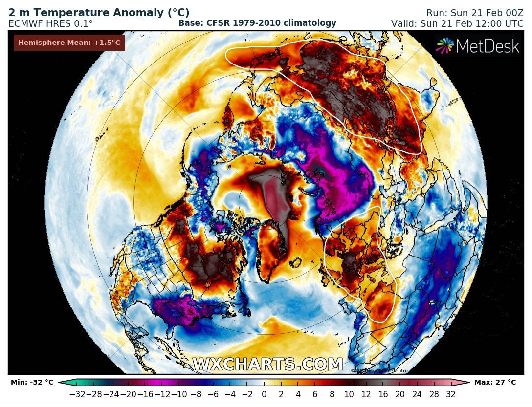
This episode of awful weather had it seeds in what I described in this blog thingy a month ago. A sudden stratospheric warming.

Way back on January 9, I described how this sudden stratospheric warming would blow the polar vortex apart. The vortex is a huge upper level pool of frigid, stormy air that usually hangs out somewhere in the Arctic. It does tend to move around somewhat. 

Or, as noted get blown apart occasionally.

We're reaping that harvest, as it were, of that event now. 

This disrupted polar vortex led to something called high latitude blocking, which is basically high pressure areas setting up around the Arctic. Pieces of the polar vortex, which is low pressure, were displaced further south 

As the Washington Post Capital Weather Gang explains it, this high pressure in the high Arctic helped displace the polar vortex into the North Atlantic. The low pressure in the North Atlantic and high pressure near Alaska channeled incredibly bitter air from Siberia, across the North Pole and straight down into Canada and the United States.

The jet stream also became weaker than it normally is this time of year. A strong jet stream tends to keep most of the cold air bottled up in Canada.

A weaker jet stream has much more pronounced curves, dips and bumps.   A big dip in this weak jet stream developed over the central United States, and that directed that awful Siberian air right down to Texas. 

Outbreaks of Arctic air usually get shunted east, at least to an extent, so that the Great Lakes and Northeast shiver in temperatures way below zero.  That's sort of OK, we're used to it. 

This time, with that big dip in the jet stream, the frigid air shot straight to Oklahoma and Texas, with little chance to modify on the way down. 

CLIMATE CHANGE?

I've seen a few wags online saying a record, intense cold wave like his is "proof" climate change does not exist. 

As I always state, a single weather event does nothing to prove or disprove climate change. 

The weather always has extremes, one way or the other.  Climate change has loaded the dice, so it's now likely there will be hot spells than cold spells.  But there will still be cold spells. 

Actually, the air temperature at its source in Siberia and the Arctic wasn't unusual. What was strange is that it made its way all the way down to the Mexican border, resulting in the extreme cold for the South. 

I've mentioned this before, but some scientists suspect that climate change can actually make these kinds of episodes more likely. 

The Arctic is warming faster than points south, so that reduces the temperature contrast between the tropics and the poles.  A subdued temperature contrast might make a weaker jet stream.  Remember what I said above: A weaker jet stream can be more prone to bigger dips and ridges. That in turn, can pull cold air south where it doesn't belong and hot air north, where it also doesn't belong. 

In fact, this is the second time in four months this has happened in the southern Plains. An out of season ice storm caused a lot of problems in Oklahoma back in October. 

But as Nature reported last November, the science around climate change and weaker jet streams and weird spells of weather is still very iffy. 

Scientists have a lot more work to do to establish whether these mega cold snaps amid an otherwise warming climate is a real thing or not.   

THE ICE

While that polar vortex in the North Atlantic was helping direct frigid air into the United States, a stronger than average ridge of swarm, tropical high pressure in the upper atmosphere established itself off the Southeast United States coast, and north of the Caribbean.

This directed -  or tried to direct  - warm, humid air toward the southeastern United States. Note that while most of the nation was freezing, Florida was enduring near record winter time heat and humidity. 

Warm air is lighter than cold air. When this toasty, humid air encountered the frigid air over much of the United States, it would ride up and over the cold air.  And there were plenty of episodes in the past week where this happened, and is still happening. 

Raindrops falling from the warm air encounter the cold air near the surface. They either freeze on the way down, creating sleet, or freeze on contact with the ground, causing the dangerous and damaging icing we've seen so much of. 

TEXAS POWER OUTAGES 

Politics over the widespread and dangerous Texas power outages as exploded. 

The outages, which affected more than 4 million Texans, is the most serious and probably most deadly outcome of this cold snap.  

Electrical grids froze up all over Texas, leading 
to massive days-long blackouts 

Texas is used to  heat waves, but cold waves of this intensity and length are super rare.  The whole state was affected, not just part of it as is typical in most winter cold snaps. 

This has probably happened maybe four or five times in the past 200 years or so. 

Demand for power spiked as people struggle to heat their homes. 

If you figure a comfortable temperature for a house is 70 degrees, you only have to cool the rooms by 30 degrees if its hot outside in the summer 

In this cold wave you have to heat the rooms by 70 degrees if it's zero outside so that takes a lot of energy. Plus, the millions of homes and businesses in Texas are designed to be insulated from New England-style winter conditions. 

The gas and coal plants weren't up to the task. Plus, these plants were not built to withstand such bitter temperatures. Gas lines froze, as did equipment in power plants. 

Most of the nation's power is controlled by two massive grids, one in the eastern half of the nation, one in the west. 

Since each power grid encompasses several states, they are subject to federal regulations that, among other things, demand that the plants are weatherized. Also, since the east and west grids are so big, they can be some electricity trading with other states if one area is affected by bad weather and another is not. 

Texas, however, controls its own power grid, controlled by the now-unfortunately named Electric Reliability Council of Texas, or ERCOT.  

The Texas power grid is not part of the eastern and western regions. They've done this in part to avoid dealing with cumbersome federal regulations. The state didn't winterize their power plants, because cold waves like this are so rare. 

When the weather hit, the plants wilted in the Arctic chill. Compounding the problem, some electricity generating plants shut down in Texas during the winter for maintenance. That's because electricity demand in the Lone Star State is usually highest in the summer. 

I've seen some blame go to wind and solar power that froze up in the cold. But these renewables only contribute 21 percent of Texas electricity generation.  

Some wind turbines did freeze up, but most of them kept working. Though power from windmills did decrease during the winter storm, that decrease from renewables was actually a little less than forecast.  Most of the problem was from gas and coal electric generating plants. 

By the weekend, temperatures in Texas will rise to levels near or even a little above average for the season - well above freezing. The power will come back on for everybody.  All those frozen pipes will thaw, causing countless new building floods, drinking water shortages and danger. 

It will take many areas of the nation awhile to recover from this disaster. That's especially true in Texas. 

Winter Storm Missing Vermont Entirely, Heading By To Our South

Snow piles that have been building up around my house
in St. Albans, Vermont are starting to make me feel
claustrophobic. The next big storm that was expected Friday
turns out to be mostly missing us. A little thawing
possible next week? End of winter approaching. 
 Just a short update today, as I have other posts on this blog thingy I also want to bring forth today and tomorrow, so stay tuned on that!   

The trend keeps getting drier and drier for us here in Vermont as that big winter storm we've been taling about all week went POOF! At least for us. 

Everything is going by to our south.  A little upper level energy will produce a bit of light snow for us tomorrow and Saturday, but it'll only amount to a dusting to three inches depending upon where you are. 

One caveat: I have seen sometimes these snowfall from upper level lows to the northwest of a distant off-coast storm to over-perform. Though unlikely, there's always a chance some Vermont snow lovers could get more than just a dusting. 

The weird, extreme weather pattern that has brought so much havoc to the nation is now untangling itself, so conditions will slowly go back to normal over the next few days. Yes, I know here in Vermont, things stayed normal through this episode.

They will continue to stay normal around here.  Another small system will come through Monday with some gusty winds and light snow.  Maybe some blowing snow, too.

We're getting toward the end of winter, so day by day, the chance of a thaw slowly go up and up. 

True, it can still go way below zero well into March, and big snowstorms can still hit Vermont well into April, but the end of winter is nigh. 

Overall, we're now starting our seasonal warming trend.  It's already looking like temperatures will get a bit above freezing on a few afternoons next week. 

That won't get rid of the snow cover, but it's a sign of things to come. As fresh and clean and beautiful the nearly foot and a half of snow outside my window is, it also makes me feel a little claustrophobic. So I'm ready for it to melt down. 


Wednesday, February 17, 2021

Next Storm A Likely Miss For Vermont; Still Going To Snow

Though not as widespread as earlier in the week, winter storm
warnings and advisories still cover huge areas of the South
 We've been eagerly - or not so eagerly - awaiting Storm #2 in this very active and wintry pattern here in Vermont. 

It is starting to look like for a good part of the state anyway Storm #2 will be largely a miss, but it's still going to snow. 

This second storm this morning was causing additional misery for the winter weather disaster zone known as Texas and much of the rest of the South.  Winter storm warnings remained in effect for much of Texas on up to Virginia. 

Once again, ice storms are ruling the roost, with damaging freezing rain accumulations expected today in eastern Texas and parts of Louisiana and Mississippi.

The freezing rain will also eventually focus on parts of North Carolina and much of Virginia, where more than six inches of snow and up to a half inch of freezing rain is expected through Friday. This will cause additional tree and power line damage in the same areas hit by ice last weekend. 

Along a stripe from northern Texas all the way to southern New England, heavy snow is falling or will fall  between now and Friday. 

However, except for maybe southern Vermont, the Green Mountain State is beginning to look like we're too far north to get smacked by the heavy snow. This storm is now aiming for an eventual path pretty well south and east of Cape Cod.

This storm's upper level support will be largely west of the storm, and for a time west of Vermont.  This will add lift to the atmosphere over us. Which means we have a long time from Thursday night through Saturday in which we'll get occasional light snow. 

It'll never snow hard, but the National Weather Service in South Burlington is thinking the long duration of the snow still means we'll get three to five inches of snow over a couple of days through midday Saturday. At least that's the initial guesstimate. More refinements to the forecast are inevitable. 

It's another case of Vermont being flurried to death. Very common for our neck of the woods. 

If you've been reading this here blog thingy, this storm was originally expected to go by to our west, at least as of the beginning of the week.  The forecasts have kept shifting the storm further and further east, so it's remarkable that a storm that last weekend was predicted to go over New York State will now go well east of New England.

Of course, there's still time for forecasts to change, so it's always possible this trend of pushing the storm further and further east could continue. Or, it could also start bending westward toward us again. 

We have reached the stage in the forecasting game, though, that the scenario I outlined above is pretty likely.  

Tuesday, February 16, 2021

Tuesday Evening Update: Vermont Escaping The Real Rough Weather; New Storm Adding Misery To Nation

The wall of snow outside my door in St. Albans, Vermont,
gets a tiny bit of additional height as a snow showers passes
through.  A little more snow at the end of the week?
The storm that swept past Vermont overnight and this morning was something of an under-performer for us. 

A fair amount of sleet mixed in with the snow statewide, so amounts fell well short of the eight to 12 inches across the north. 

Totals were more like three to six inches. Plus, many valley locations, and even some mid-elevations south, had a sort of mini-thaw as temperatures briefly climbed into the mid 30s.

Careful out there driving this evening. A cold front of sorts has created a line of brief but relatively hefty snow showers along with falling temperatures. It's moving west to east, and especially hitting northern and central New York. 

Roads are rapidly becoming ice covered as temperatures go below freezing, and the snow is making it worse. The snow won't amount to much, but it will make things challenging. 

Tomorrow and most of Thursday will be pretty quiet and sort of cold, but nothing outlandish, like what's happening in the Midwest and South. 

Everybody is still watching a new developing winter storm that's producing a new round of unwanted heavy snow and severe icing in the South 

As advertised, that storm is heading toward New England, and winter storm watches are already up for most of central and southern New England later Thursday and Friday. Heavy snow and ice are anticipated there. 

Forecasts for this late week storm have been all over the place, but keep trending further and further east.  If this holds, we might not get all that much snow, except maybe in southern Vermont. 

We'll have to watch the trends to see if they keep pushing this thing east, or reverse themselves.

It's looking like it'll warm up next week, and we might start having a few more above freezing afternoons. It's getting toward the end of winter, so thawing should slowly become more common as we head toward and into March. 

NATIONAL NEWS

The winter siege continues unabated the middle of the nation and South

Places like Dallas and Oklahoma City had their coldest morning in more than 100 years today, with a 14 below reported in OKC and 2 below in Dallas.  The average temperature for the entire state of Oklahoma was a bit below zero yesterday, the first time on record that has happened

Now, they're getting another snowstorm. 

A section of Interstate 35 in Austin, Texas Monday morning.
Locals say this stretch of road would normally be jam packed
with morning commuters at the time this photo was taken

Usually, when there's a record low, it exceeds the old record by only a couple or few degrees. This time, the record lows completely obliterated the old records. Shreveport, Louisiana got down to 1 degree above zero, breaking the old record by 19 degrees!

Tyler, Texas reported 6 below, beating the old record low for the date of 17 above.

There must be hundreds of thousands of homes, at least, with frozen pipes, especially considering all those long lasting power outages in Texas and Oklahoma. Power in some spots might not come back on until later in the week. 

In some spots, like Oregon and the Chicago area, accumulated snow and ice has led to some building collapses.

In Utah, up to four feet of snow in the mountains this week fell on unstable snow, leading to an extreme avalanche risk. 

In the Northern Plains, things are finally getting much better. Tonight will be the eleventh in a row with temperatures in the teens or 20s below in Grand Forks, North Dakota, but by early next week, afternoon readings are forecast to go above freezing. 


Tuesday Morning Storm Update: Havoc Nationwide; In Vermont Icy Mix To Canadian Border

People try to free cars stuck on ice and snow amid subzero
wind chills in (checking notes) Waco, Texas.
The mad, mad, mad weather of February continues, with widespread power outages in the South affecting millions, a growing death toll,  tornadoes, every kind of precipitation in the book, and finally, a glimmer of hope that this will all end. 

Meanwhile, here in Vermont, the latest winter storm turned into a sleety mess all the way to the Canadian border, and we're watching the next storm for Thursday night. More on that in a minute.

First, as usual, we need to summarize the awfulness going out in much of the nation right now.  5 million people had no electricity across the nation, 4 million of them in Texas. 

CNN is reporting at least 15 deaths so far, mostly due to crashes on icy highways.

The famous phrase, "Houston, we have a problem," has never been more true than today, and it applies to all of Texas, really. 

The crisis involving the power grid in Texas worsened overnight.  Intense cold has frozen equipment at gas generated power stations, shutting at least 30 of them down.   Despite the current narrative, frozen out wind turbines are not the main issue.  Reports are probably 2 percent of the state's wind turbines went offline because of the extreme weather. 

With record temperatures statewide, demand is through the roof. So practically the entire electrical system in Texas shut down.  The result is roughly 4 million homes and businesses in Texas without power. Some people have had no power since yesterday morning. 

Homes now have interior temperatures below freezing and frozen pipes are bursting all over.  I greatly fear that news will emerge of many deaths from exposure to the cold due to this situation. This is especially true among the elderly and the poor, who don't have the resources to move to a toastier refuge or buy supplies to keep them warm. 

So, watch this space. 

The extreme weather is causing all kinds of weirdness. One instance: Arctic sea smoke was seen off of Galveston. That's steam coming off the warm waters and condensing in the frigid air. Arctic sea smoke is common in places like New England.  In coastal Texas, not so much.  

Lake effect snow flurries were reported downwind from small lakes and bayous around Houston.  Such activity is often seen coming off lakes here in the Great White North - including off of Lake Champlain. But Houston?

The high temperature in Oklahoma City Monday was just 4 degrees.   And OKC managed to do that despite sunny skies! At last report early this morning, it was 10 below in OKC, and the temperature was still dropping. If it makes it to 12 below, it will be the second coldest reading on record there. 

Ahead of the cold front, a deadly tornado struck coastal North Carolina, killing three and injuring 10, NPR reports this morning. 

Elsewhere,  at least three tornadoes touched down in northwest Florida and southwest Georgia, injuring at least one person  More tornadoes are possible today and tomorrow ahead of the second winter storm coming through the South.

That second storm will produce another wave of snow, sleet and freezing rain on top of what is already there in Oklahoma, Texas and Louisiana.  This second storm will add another stripe of snow and destructive ice up the Appalachian chain in the coming two days. 

At least there are signs the end of the winter siege is coming.  Grand Forks, North Dakota went above zero last evening for the first time since February 5. 

Next Monday, the forecast high temperatures are 52 in Oklahoma City, 60 in Dallas and 66 in Houston

VERMONT IMPACTS

That trend toward mixed precipitation moving more and more north continued overnight, and as of this morning, sleet was falling all the way north to the Canadian border.

Traffic on snow packed Fairfield Hill Road in St.
Albans, Vermont Tuesday morning as sleet
made things even a bit more slippery. 
This is cutting down on snow accumulation totals, but will make cleaning up the accumulation heavier and harder. So far, it seems like accumulations are in the two to six inch range across most of Vermont.  

As of 5:30 a.m., my place at St. Albans had accumulated just 3.2 inches of snow and sleet and sleet was falling at the time.  Light sleet continued on after that, and it was still coming down as sleet as of 8:30 a.m around here. 

All this is a lot less than expected, at least in the northern half of the state. 

Warm air really moved in aloft over southern Vermont.  A temperature inversion is keeping most areas down there as freezing rain. But to give you an idea of how warm it is aloft, strong downslope winds are pulling the warm air up high down to the surface in Bennington, where it was 41 degrees early this morning. 

Since there was much more sleet than freezing rain in Vermont, so ice didn't cling to trees much. So power failures aren't a big issue. Some ice is clinging to trees in far southern Vermont, but there's only a few isolated outages down there. 

An intrusion of dry air into the storm system was starting to make precipitation come down at a lighter pace as of mid-morning across Vermont.  This state of affairs will continue through the day. However, that warm air aloft will start to erode, so precipitation should turn back to snow. In the north especially, we are in for another one to possibly as much as three inches of additional snow once things switch back. Maybe a little more in the mountains. 

Needless to say, the roads are crappy through the region. Though crews are out, the roads will never get perfect until the snow and stuff ends tonight. 

The next storm down the pike continues to look snowier and snowier, the opposite trend this current storm ran. The projected path of the storm Thursday and Friday keeps going more and more east, so we'll stay in the cold air on the western flank of the storm.

There's even a low chance the next storm's projected path could go so far to the east that some of us miss out on the heavier snow.

Everyone expects plenty more adjustments to the forecast for the next storm after today, so we should sit back, relax and see how it plays out. 

Monday, February 15, 2021

Monday Evening Update: Texas Situation Worsens, Widespread Ice; Vermont Forecast Changes

Latest update snow prediction map from National Weather Service 
in South Burlington. Still looking at 8-12 inches north, but the
12 inches most likely near Canadian border. Lots of sleet
and freezing rain far south.  Some sleet could make to or
even north of Route 2.
The winter weather disaster unfolding across the nation continued to worsen during the day today.

 The rather dire situation in Texas got worse today as power remained out for more than 2 million Texans amid record cold and wind chills around zero.  

We're still expecting a decent winter storm here in Vermont, with some more changes in the forecast. More on that in a bit, but first we should deal with the national drama. 

In Texas, people are in pretty dire straights in freezing homes. According to the Texas Tribune:

"The state's electric grid operator lost control of the power supply Monday morning as 2 million Texas households didn't have heat or other electric appliances working at home as a massive winter storm delivered freezing temperatures across the state. 

When the state's grid operator, the Electric Reliability Council of Texas, began implementing rolling blackouts at 1:25 a.m. Monday, the outages were intended to be implemented on a rolling basis - up to 45 minutes per affected area, according to the ERCO."

People are in danger as a result. Medical devices aren't working. Temperatures inside some Texas houses are now subfreezing. Pipes are freezing and bursting. This is a critical crisis for Texas, especially since the power outages are expected to last at least into tomorrow. Overnight lows in Texas will range from 10 below to 10 above, so this is very dangerous. 

About 90 to 95 of the homes in Galveston were without power Monday. With all those freezing pipes, locals say the damage could be worse those hurricanes that are more common than winter storms on the Texas coast.

Meanwhile, normally busy downtown Houston was a ghost town.  Ice covered freeways were empty, which was a good thing since travel is so dangerous.

A total of 140 million Americans were under winter storm warnings and advisories, including us few souls up here in Vermont. 

Since we had to put in every kind of misery possible, severe thunderstorms and some possible tornadoes were breaking out late this afternoon in the Florida panhandle and southern Georgia 

VERMONT IMPACTS

The trend we talked about this morning, where the sleet and freezing rain first predicted for southern Vermont, has been creeping northward in the forecast.

Basically, the trends have been toward a little warmer and more mixed precipitation with tonight and tomorrow's storm, and a little colder and snowier with the expected storm Thursday night and Friday. 

As advertised earlier, everyone will start with a good thump of snow later tonight.  There has already been some periods of light snow, which had been expected. More areas of light snow and flurries will continue this evening before things ramp up later on. 

The heaviest precipitation is expected between around midnight and 9 a.m. Tuesday. That part of the forecast hasn't changed either. The Tuesday morning commute is going to be a mess.  In the north, snow will come down at a rate of an inch or two per hour early Tuesday, so that will be impossible for the snow plows and salt shakers to fully keep ahead of. 

Stay home tomorrow if you can! 

What's different in the forecast now is the sleet might now mix in all the way north to Route 2 or even a bit beyond that for a time Tuesday morning. Also the precipitation will lighten and maybe turn to freezing drizzle for a time Tuesday afternoon all the way to the Canadian border. Later in the day, it will switch back to snow showers. 

Further south, sleet and freezing rain will dominate after the initial thump of snow tonight.  Unlike this morning, I'm now worried that enough freezing rain will accumulate on trees and power lines in far southern Vermont to start breaking branches and lines 

This issue won't be as bad as points further south where a destructive ice storm is likely. But scattered power outages are possible tomorrow, especially south of a Springfield to Bennington line. 

Overall, the National Weather Service in South Burlington is still forecasting 8 to 12 inches of new snow north of Route 2, but the highest chances of a foot are right near the Canadian border. Near Route 2, sleet could hold down accumulations a little bit. 

Further south, through central Vermont, it'll be more like four to eight inches, but all that sleet and some freezing rain will make that accumulation terribly heavy and hard to clean up. 

And we'll write far southern Vermont off as an ugly, icy mess. As little as two inches of schmutz and ice will accumulate in the valleys near Bennington and Brattleboro.

Since it will stay cold until the next storm, any ice on trees in southern Vermont will remain for the next storm. If that next storm has freezing rain or wet snow, there could be some real trouble with power failures and broken tree branches. Freezing rain and wet snow is most likely in the south with that second storm.

That said, the trend continues to be a little bit toward more snow and less ice Thursday and Friday. That trend could still reverse itself, so I wouldn't bet on anything in particular toward the end of the week. Just expect a very busy winter week around here.