Saturday, October 31, 2020

Southern New England Snowstorm Breaks Records

Up here in the northwestern corner of Vermont, it was just cold Friday, but no drama other than that. 

Traffic cam from Winhall, in southern Vermont, still shows
a decent amount of snow on the ground this morning.

It was a completely different story in parts of southern and central New England, which was genuinely hit by an early season snowstorm.  
 

The records set in Boston were especially impressive. That city recorded 4.3 inches of snow, smashing the previous record for an October snowstorm. The old record was 1.1 inches set in October, 2005. 

Oddly, Friday's snowstorm in Boston was their largest so far in this year.  The biggest snowfall for 2020 up to this point was three inches on January 18.

Boston this year also had a late snowfall on April 18, with 0.7 inches of snow.  That means this year's 193-day stretch between measurable snows in the spring and autumn was the shortest on record. 

Coastal Massachusetts can and does get huge winter snowstorms, of course.  But things have to align just right for those areas, including Boston, to get a decent snow.  These snowfalls typically come with nor'easters. If the center of any of these storms ventures too close to the coast, enough warm air sneaks in to quickly change snow to rain.

This time, the storm moved far enough off the coast to bring a snowfall to Boston.

Elsewhere, Worcester, Massachusetts had its third largest October snowstorm with 6.2 inches.

Southern and eastern Vermont shared in the snowfall late Thursday and Friday morning, but it didn't set any early season records. Andover, Vermont reported 3.5 inches of snow, and Danby had three inches. There were widespread reports of one to two inches of snow across southern and much of eastern Vermont. 

As I'm sure everybody has noticed, the snow was followed by a really cold moment this morning. The notorious cold spot Saranac Lake, New York bottomed out at 7 degrees. In Vermont, Island Pond got to at least 12 above zero. 

In southern New England, record lows were tied at Hartford, with 21 degrees, and Providence, Rhode Island, with 24 degrees.

We're in for another, possibly stronger cold shot Sunday night through Tuesday. This time, accumulating snow is a good bet in northern Vermont, which missed out on Friday's snowfall.

A strong cold front will pass through Sunday night, and low pressure might form along that front east of here.  That would throw at least some snow our way.  It probably won't amount to too much in the Champlain Valley, but a few inches could come down in the mountains.

Monday will be brutally cold for early November, as temperatures fall through the 30s amid gusty north winds and continued snow showers. 

A secondary disturbance will create more snow and wind Monday night and Tuesday, again with the highest accumulations in the mountains.  

Luckily, this won't be like last November, when winter set in for good during the beginning of the month. This year, we'll get an abrupt shift to warmer weather mid-week, with highs in the 50s by Thursday and near 60 by Friday. 

Friday, October 30, 2020

A Lack Of Siberian Arctic Ice And You

Arctic Ocean water near Siberia is not freezing like 
it's supposed to this time of year. 
 As of late October, the Arctic Ocean near Siberia wasn't yet covered in ice. 

This, according to scientists, is very odd and dangerous, another sign that climate change is messing with the Arctic. 

That area is essentially the Northern Hemisphere's air conditioner. If the air conditioner is out of whack, bad things can happen. 

Usually, the Laptev Sea, the part of the Arctic Ocean near Siberia, starts to freeze in late September as the waning autumn sun stops heating the surface. 

This year was so hot, and the heat was so unprecedented, that this section of the Arctic Ocean really warmed up - much more than usual.  With the water so warm, it takes time for the heat content to dissipate into the atmosphere amid the late autumn darkness. So the ice is late.

This can lead to a feedback loop that can ensure less and less ice. The freeze up north of Siberia is late, so chances are the ice that does form won't have time to thicken up to the extent it does most winters.  Which will make it easier to melt next spring. 

Overall, sea ice extent in the entire Arctic was the second lowest on record in September, continuing a decades long trend of declining sea ice. 

As I've mentioned before in this here blog thingy, a lack of Arctic ice might make the weather screwy down in the mid-latitudes, where most of us live.  

The lack of Arctic ice, and the overall warming trend up there, might make the jet stream wavier and more meandering than normal, causing spells of extreme weather. 

This past week, an Arctic blast of unprecedented cold dropped temperatures to as low as 30 below in the northern Rockies, the coldest on record for October.

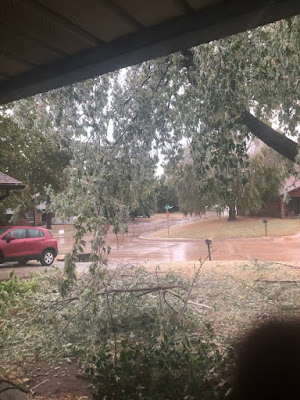
In Oklahoma and Texas, where temperatures this time of year are normally in the pleasant upper 60s and low 70s, a crippling ice storm collapsed thousands of trees that still had green leaves on them.

It does seem absurd to blame record cold and winter storms on global warming.  And to be sure there is NO WAY I have the knowledge or expertise to conclusively tie the bizarre winter weather out west this week to climate change. 

Still, this episode of weird weather is consistent with what scientists are saying about a weirding out jet stream.  

For instance, overall, the continental United States has shown a clear upward trend in average temperatures over the past few decades at least.  But this trend gets occasionally interrupted by some pretty wild cold snaps. 

A great example of what I'm talking about has happened right here in Vermont.  Last November, we had some of the coldest weather on record for so early in the season in the Green Mountain State.  On Mother's Day weekend this year, it snowed. 

Yet, last winter was Burlington, Vermont's eight warmest winter on record and this past summer was THE hottest on record. 

Whether or not rapid Arctic warming contributes to these strange weather episodes like we've had this past week, the wildly erratic jet stream can have dangerous influences far and wide.

The Washington Post Capital Weather Gang reported a terrific example of this:  Hurricane Zeta was on approach to Louisiana Wednesday.  Cooler ocean temperatures near the coast and expected upper level winds would temper the strength of Zeta, making it barely a Category 1 storm at landfall. At least that was the expectation.

But nope:  Zeta strengthened to a high end Category 2 storm with top winds of 110 mph, definitely causing more wind and storm surge damage in Louisiana, Mississippi and Georgia than expected.

What happened?  The jet stream, dipping so far south into Texas, allowed air in the upper levels of the atmosphere to spread out near Zeta.  That allowed Zeta to ventilate itself.  Hurricanes need rising air to fuel the thunderstorms that contribute to their power. 

This diverging air encouraged the thunderstorms in Hurricane Zeta, allowing the storm to strengthen and overwhelm any negative influence from cooler water or strong winds in the upper atmosphere. 

As the Washington Post reported:

"In meteorology, extremes tend to beget extremes, and Zeta's fury was yet another example. It was a hurricane paradoxically intensified by an ice storm that cut power to hundreds of thousands several hundred miles away."

If extremes lead to extremes, and climate change leads to more extremes, this is all bad news. As I said before, I don't know if the weird weather of this past week was related to climate change or to what extent if it was. 

I do suspect climate change had some role. If that's the case, expect more crazy weather weeks in our future. Ones that feature wildfires, hurricanes, ice storms, weird temperatures, and God know what else.

 Hang on to your hat! 


Thursday, October 29, 2020

Hurricane Zeta's Mess And Two Winter Cold Shots Here In Vermont

 Hurricane Zeta caused a lot of trouble from Louisiana to the Carolinas yesterday and overnight, cutting power to 1.9 homes and businesses as it raced toward the Middle Atlantic States.  

Satellite view taken Wednesday of Zeta swirling in the lower
 left in photo with a large winter storm cloud shield to the 
west and north of it. 

Two deaths have bee reported with Zeta so far. 

The hurricane, with top winds of 110 mph, made landfall near Cocodrie, Louisiana late Wednesday afternoon.  The eye of Zeta went right over downtown New Orleans, where lots of wind damage was reported.

The storm also caused huge trouble in southern Mississippi with hurricane force winds and storm surges. 

Because the storm was moving forward so fast, it didn't have a chance to 

weaken inland, so destructive winds extended all the way to Atlanta, Georgia and beyond into the Carolinas. 

Believe it or not, we might not be done with tropical storms in the Atlantic. The National Hurricane Center is giving a disturbance in the eastern Caribbean Sea a 60 percent chance of development in the coming five days. 

If that one becomes a tropical storm, we will tie the record for the most tropical storms and hurricanes in a single season. That would bring us to 28 such storms, the same number as in 2005.

Zeta is about to merge with a storm coming in from the west, and will cause heavy rain and gusty winds in the Mid-Atlantic states.  Cold air feeding into the storm will change rain to snow in parts of New England, and here's where we get into Vermont's introduction to winter. 

VERMONT COLD

Winter weather advisories are up for the southeastern corner of Vermont - Bennington, Windsor, Windham and eastern Rutland counties for tonight. 

Rain associated with Zeta's remains will change to snow this evening and dump one to as much as locally four inches of snow on that part of the state. Travel could be a little slick down that way by tomorrow morning 

Precipitation amounts will taper off rapidly as you head north, and places north of Route 2 probably won't get anything at all.

However, all of us in the Green Mountain State are in for the first shot of winter cold. If you have stuff outside that can't stay there in freezing weather, bring them in today. 

Temperatures won't get out of the 30s tomorrow.  Tomorrow night, winds will die down and skies will clear, leading to a frigid early Saturday morning. Most of us will be in the teens, with the colder spots in the single digits. 

That brings us close to record lows.  The record low in Burlington Saturday is 17 degrees and Montpelier's is 16 degrees. Of the two, Montpelier's is the most likely to fall.

After a brief sorta, kinda, warmup over the weekend, and even sharper winter cold snap is likely Monday and Tuesday.  It looks like pretty much everyone will get snow early next week, but accumulations should be light. 

Before you get all upset over that, the second cold snap early next week will be brief, too. We'll get a strong warmup during the second half of next week. 

Also, if you still have autumn chores to do - I certainly have them! - this won't be as bad as last year. In November, 2019, hard core winter settled in around November 8 and stayed put, so chores outdoors went undone until spring. 

This year, we'll have some warm spells mixed in with cold shots well into the middle of November, and it doesn't look like we'll have a continuous, month long snow cover like last year. 


Wednesday, October 28, 2020

Hurricane Zeta To Slam Gulf Coast Today

Hurricane Zeta this morning looking healthy and
targeting Louisiana and Mississippi 
 It wouldn't be the year 2020 without yet another hurricane over performing and getting ready to wreck another part of the United States Gulf Coast.  

Hurricane Zeta strengthened pretty robustly last night, and was packing highest sustained winds of 90 mph on approach to the Gulf Coast early this morning. 

Zeta has a shot at strengthening a bit more before cooler coastal waters, stronger upper level winds and proximity to the coast shut off the fuel that keeps letting Zeta becoming muscular. 

So, Louisiana, Mississippi, and Alabama are in for a big blow later today and this evening. 

Forecasters have upped the predicted storm surge to as much as six to nine feet above normal sea level.  

Zeta's forward speed is faster than the usual Gulf of Mexico hurricane, so that will help winds be stronger on the eastern side of the storm.  That's because on the eastern side of a northbound storm, you have to add the winds of the storm with the forward speed to get what actually  happens.

The fast forward speed means that winds will continue to blow strong and damaging well inland, because Zeta won't have time to weaken much once it moves inland, since it's moving so fast. A tropical storm watch is in effect as far inland as the Atlanta, Georgia area.

The only bright side is the forward speed is so fast that epic inland flooding is probably not in the cards. The storm won't have time to dump huge amounts of rain. 

However, hurricane rains are torrential, so some flooding is inevitable. On top of that, as Zeta dies inland, it will merge with another storm to create a soaking, potentially flooding rain in parts of the Deep South, Tennessee Valley and Mid-Atlantic States.

This will be the fifth hurricane to strike the Gulf Coast and third time a hurricane has struck Louisiana this year, so I'm sure everybody has had enough by now. 

It'll be the latest in the season a hurricane has struck the Gulf Coast since Hurricane Kate on November 22, 1985. 

For Hurricane Zeta, evacuations are ongoing in advance of the storm.  Low-lying Grand Isle, Louisiana is being evacuated for the fifth time this year due to Hurricanes.  

Metro New Orleans is included in the hurricane warning, so we'll have to watch their levees. Hopefully they'll hold and avoid any catastrophic flooding. Until now, all these hurricanes this year have largely missed New Orleans. Not this time. 

It still looks like the combined remnants of Zeta and that storm from the Plains will dump some snow on New England Thursday night. It looks like most of it will hit higher elevations of central New England. 

The southern half of Vermont stands to see a couple inches of snow with this, with maybe four or five inches in the higher elevations. So far, it's looking like northern Vermont will get little or no snow.  Expect a wintry day on Friday, though, as high temperatures will barely make it above freezing in some spots.  A north wind will add to the chill.

Tuesday, October 27, 2020

So Let's See How All That Weird Weather Is Going

Night time aerial view of the wildfire near Irvine, California
with heavily populated areas visible just to the left of the'fire
Photo is from ABC7 

Yesterday, I talked about how extremely wild and weird the weather is across the United States.

It's worth a check on how things are working out with this, so here's the update:  

CALIFORNIA FIRES

The good news, I supposed, Monday was bad in California, but not as bad as it could have been.

The worst news from the blazes was that two firefighters were critically burned battling a fast moving wildfire near Irvine, California.  That blaze forced the hasty evacuation of 60,000 people from the Irvine area. Another blaze a little to the north forced 5,000 people out of their houses in Yorba Linda. 

It's unclear at this point how many of those homes have burned, but it's clear that firefighters saved a lot of them, for sure. 

Northern California so far has dodge a bullet. The worst weather conditions for wildfires there was over the weekend.  Firefighters managed to suppress new fire starts remarkably well, given the conditions they were facing. 

It ain't over yet. Today, in both northern and southern California, continued strong, gusty winds and incredibly low humidity levels continue the risk of rapidly spreading fires.  Winds subsided overnight in southern California, but were picking up again early this morning.  Those fires near Irvine and Yorba Linda are also nowhere near under control, so those might cause more havoc.

WINTER STORM

The snow and ice in the southern Plains has worked out pretty much as expected. In other words, unprecedented. Winter storm warnings continue as far south as Midland-Odessa, Texas, where snow and freezing rain continue to fall.

Ice accumulating on still leafed-out trees is causing a lot
of damage in Oklahoma. 
The normal high temperature in Midland, Texas today is 74 degrees. The forecast high is just 32 degrees amid continued freezing rain. 

This mess, as expected, extends up through Oklahoma.  In the winter storm zone with all this freezing rain, the leaves are still mostly on the trees. The weight of the ice has those trees crashing down, and that will continue today. 

Television station KOCO reported at least 90,000 homes and businesses in Oklahoma without power.  One couple in Yukon, Oklahoma was resorting to using two by fours to prop up the sagging branches of their prized pecan tree. 

The scope of the cold air remains incredibly impressive. Up in Laramie, Wyoming, it got down to a whopping 26 below zero this morning. That's not wind chill. It's actual temperature. It's obviously the coldest on record for Laramie for October, and it's also the colder than the lowest temperature on record for the entire month of November. This is really something!

Further south, normally temperate Albuquerque, New Mexico endured a record low of 19 degrees, 2.9 inches of snow and winds gusting to 58 mph on Monday. 

I'll have more in a near-future blog post as to how oddly unfrozen water near Siberia and elsewhere in the Arctic might have contributed to this weeks winter weirdness in the Rockies and Plains. 

TROUBLE FROM ZETA

Once and likely future Hurricane Zeta is still a big threat to the U.S. Gulf Coast.  Zeta made landfall as  a hurricane last night in the Yucatan Peninsula of Mexico. It was the third time that region has been hit by a hurricane this year. 

Because of its interaction with land, Zeta at last check was a tropical storm with top winds of 70 mph. It is expected to strengthen into a hurricane again today in the warm waters of the southern Gulf of Mexico. 

Zeta will come ashore sometime tomorrow afternoon or evening somewhere near New Orleans, packing winds of up to 85 mph and storm surges of two to six feet.  Any storm surge is dangerous in Louisiana given the wide areas that are barely above sea level. 

This will be a record fifth time Louisiana has been hit by a hurricane or tropical storm this year. On the bright side of sorts, Lake Charles, Louisiana, battered by two destructive hurricanes this year, will only see rather minor effects from Zeta

FLOODS, THEN NORTHEAST SNOW?

Once inland, future Hurricane Zeta will merge with the storm responsible for the wild winter weather in the Plains. Parts of the Ohio Valley and Mid-Atlantic States could see some flooding from this.

Cold high pressure will be pushing into this storm systems, so rain will probably turn to snow with this thing Thursday night in parts of the Northeast.

It's still unclear where the snow will focus, but it looks like the higher risk areas are upstate New York and central New England.  I'm not sure how much snow will fall.

Here in Vermont, the forecast is tricky, to say the least. The storm has a lot of moist air with it, but that cold high pressure system coming in from the northwest is super dry.  Vermont will be in the battle zone between those two systems. That means we'll probably see a big gradient between next to nothing in the far north to maybe a few inches of snow in the high elevations south. 

Of course, a slight jog to the north with this storm would put more areas of Vermont in play for snow. Or if there's a minor shift to the south, this will be a whiff for Vermont.  


Monday, October 26, 2020

Weather Off The Rails Again: Oklahoma Ice; -29 Montana, Zeta, California Fires

Trees are beginning to collapse in an
unprecedented early season Oklahoma
ice storm today. Photo via Twitter by
Jason Chandler  
 A few days ago, I posted in this here blog thingy that the current weather pattern is similar to one of the most extreme patterns in history - late October and the first few days of November, 1991.

Back then, New England was battered by the "Perfect Storm," the Midwest had an unprecedented early season cold snap and blizzard, and the Oakland Hills in California burned, killing 25 people and destroying thousands of homes.  

Last week, I said this episode wouldn't be as wild as 1991.  It turns out, though, that this weather pattern is close to being as off the rails as 1991.

The only thing missing this time is the Perfect Storm.  A weak system is dropping light rain and a little snow on New England.  But things could get quite interesting along parts of the East Coast later this week, more on that in a moment.

Let's go with the immediate headlines first.

There's a big ice storm going on in Oklahoma now.  They happen from time to time there in the winter, but October?  That's totally unprecedented.  And even more dangerous and destructive than most ice storms.

That's because leaves are still on the trees there.  A half inch of ice, which is predicted, is more than enough to break leafless trees and by extension power lines. With leaves on the trees, the destruction will be terrible.

Snowstorms with leafed out trees are very destructive, but some of the snow slides off, mitigating a little bit of the trouble.  Not with ice.  People throughout central Oklahoma, including the Oklahoma City metro area can expect long lasting power failures.

The temperatures supporting this ice are ridiculously colder than normal.  The normal high temperature in Oklahoma City this time of year is around 70 degrees. It'll be in the low 30s this afternoon. 

The extreme temperatures are widespread. Stockton, in southwestern Texas was 94 degrees Sunday afternoon. Today, it will be in the mid-30s.  The entire Texas Panhandle and surrounding areas of the state are under a winter storm warning for freezing rain and snow. 

A goofy screen shot as ABC Meteorologist Ginger Zee
reports on record early season cold in Montana.

Way north, in Rapid City, South Dakota, normal high temperatures are in the upper 50s.  Sunday, the maximum temperature there was 17 degrees, or an incredible 41 degrees below normal.  Today will be the firth consecutive day in Rapid City that failed to rise above freezing. 

In Potomac, Montana, the temperature was a whopping 29 degrees below zero Sunday morning, the coldest for so early in the season anywhere in the United States outside Alaska.  Missoula, Montana, reached 7 below, the earliest sub-zero reading in that city - by a full 7 degrees! Cheyenne, Wyoming got down to 1 above the coldest for so early in the season

WILDFIRE DANGERS

California managed to get through a dangerous weather day Sunday without any major wildfires, but I suspect the same won't be true today.  This cold wave in the Rockies and Plains is also causing a similar weather situation to that in California during the 1991 Oakland Hills fire I mentioned.

As of noon, satellite imagery was spotting new fires in California. Blazes were breaking out near Irvine, where evacuation orders were in effect as of late morning.  Other fires were in the Sierra Nevada east of Lake Tahoe, near Redding and in other areas.

Strong, dry Diablo winds continue to blow in northern California today and even stronger Santa Ana winds are blasting southern areas of the state.

Even without fires, the wind will be strong enough to cause damage to trees, power lines and even structures. Protected valleys in the Los Angeles Basin could still gust to 50 mph. Mountains and canyons can expect gusts in the 60 to 80 mph. 

Imagine what would happen in those conditions if new fires start.  Here's what the National Weather Service office in Los Angeles had to say about the situation:

"A particularly dangerous situation is expected for the Los Angeles County mountains Monday afternoon and evening due to the unusual combination of damaging wind gusts of 60 to 75 mph, single digit humidities and extremely dry vegetation. New fire ignitions will have the potential for very rapid fire growth, extreme fire behavior and long range spotting, resulting in a significant threat to life and property"

Sounds lovely.

TROPICAL STORM ZETA

Zeta is still chugging along in the western Caribbean Sea.  It'll clip Mexico's Yucatan Peninsula and then make a beeline for the central United States Gulf Coast.  It looks like Louisiana is under the gun again, for the fifth time this year

Current forecasts have Zeta at possibly Category 1 status as it reaches the coast, which is enough to cause more damage from storm surges, flooding and high winds. 

Once it moves inland, Zeta will merge with the storm that's currently causing the freezing rain in Oklahoma, and turn into a big rain maker in the lower Ohio Valley and parts of the Southeast, where flooding is possible.

If moisture from this thing makes it far enough north, an early season snowstorm is possible in parts of New England Thursday night or Friday.  It's still too soon to say for sure whether it will snow in New England not to mention how much and where.

This does have the potential to make things pretty interesting, though.


Sunday, October 25, 2020

Fire and Ice And Tropics And Danger

Unfortunately, scenes like this are likely in California over
the next few days as the wildfire danger becomes
extreme again across much of the state
The next few days are going to be pretty nasty in the weather department for the nation as a whole, with some big dangers from wildfires, a winter storm, flooding, and a possible hurricane.  

Luckily for us Vermonters, it looks like we'll be mostly sitting on the sidelines for this one. 

Let's go through the hazards:

WILDFIRES

This is probably going to be the worst of the lot, especially in California, where weather conditions are lining up perfectly for extreme fire storms.

Winds from the north and northeast will pick up dramatically in central and northern California, gusting to 60 or 70 mph or more in some spots. Most of California north of Sacramento is under the gun later today, through tonight and Monday. 

The humidity is also expected to drop to the floor, basically.

Often in these scenarios, the high winds don't make it all the way to the coast, concentrating the fires a little inland in California. This time, the high winds will extend all the way to the beaches, putting the San Francisco Bay area in particular peril this time.

Probably the most famous example of such a wildfire/wind event was the Oakland Hills wildfire of October, 1991. That fire killed 25 people and destroyed thousands of homes, so you can understand the danger the area faces today.

To get an idea how horrifying this situation can get, check out the video at the bottom of this post of the 1991 Oakland Hills fire. The first few minutes of the video in particular is so awful it had my heart racing in fear. 

This is the highest risk California has seen this year for fires, and 2020 has already been an extreme year for devastating wildfires.

Things are so dangerous that Pacific Gas and Electric plans to cut power to 500,000 customers ahead of the wind. If the electricity is out in high risk areas, falling power lines in high winds won't be live. That means those dead wires won't be able to start fires.

In some of highest risk areas, where evacuation routes can quickly get jammed, local authorities are suggesting people leave now, before any fires even start.  Some of these high risk areas include the Berkeley Hills near San Francisco. 

Everybody else in the high risk fire zone has been told to have a full tank a gas in the car, and essential possessions like medication, pandemic protection, insurance papers and other materials stacked by the door, ready to grab in an instant if evacuation warning sound.

Fire trucks are already parked in some high risk zones, too.  This must be terrifying for the people who live in these areas.

The extreme risk of fire will spread to southern California on Monday. 

In Colorado, a winter storm swept into the worst fire zones last night, which will help tamp down the blazes. Of course, the winter weather is causing its own problems

SNOW AND COLD

The winter storm that is finally suppressing Colorado's wildfires (at least for now) is an awfully widespread affair for October. 

Places like Spokane, Washington, and several cities from Montana to Minnesota have had their largest October snowstorms on record or their snowiest October on record. And it's still snowing. 

Winter storm warnings and advisories extend as far south as the northern tip of Texas.  The storm is concentrated in the High Plains of Colorado, Wyoming, Nebraska and South Dakota, and in parts of the eastern Rockies. 

The storm is accompanied by record early season cold. Temperatures a few degrees either side of zero extend through the northern and central Rockies, the Dakotas and parts of Minnesota.

Luckily, it looks like this bout of winter won't last until spring or something ridiculous like that. Temperatures in the winter storm and cold region should get up into the 40s and 50s later this week, which is normal in these areas for this time of year. 

TROPICAL STORM ZETA

Meanwhile, Tropical Storm Zeta has formed in the western Caribbean Sea and is expected to become yet another United States Gulf Coast threat later this week.  Though the forecast path and strength of this storm is iffy, there's a good chance a strong tropical storm or  hurricane could hit the central Gulf Coast midweek.

Once inland, Zeta will meet up with the storm causing the winter out west to dump heavy rain in parts of the South and Mid-Atlantic states. Flooding is a good bet during this week. 

At this point it doesn't look like moisture from Zeta will make it far enough north to affect Vermont. But in the off chance it does, it could be cold enough to snow, not rain in parts of Vermont at the end of the week. Stay tuned! 

Here's that terrifying video of the Oakland Hills fire in 1991 I told you about:


Saturday, October 24, 2020

Hope You Enjoyed The Mild Autumn Weather: It's Over

Because of recent mild nights, I still have zinnias blooming
in late October against a backdrop of fading fall colors in
St. Albans, Vermont. Upcoming colder weather will
finish off any lingering live plants in my gardens.
Yesterday in Burlington, Vermont, the temperature reached 76 degrees, just two degrees shy of the record high for the date, and 22 degrees above normal. (It was considerably cooler in eastern Vermont).

Before dawn this morning, it was almost summer-like, with temperatures still in the 60s in the Champlain Valley.  

If you didn't get out to enjoy the warm weather, you missed your chance. 

Yesterday was likely the last truly warm day until next spring.  Sure, we'll have a few mild days in November, but chances are the 70s will not make a return for four or five months at least. 

Starting this afternoon, we Vermonters will have some pretty typical conditions for November, even though we're not quite at that month yet.

Temperature for most of us will be in the 40s by this afternoon, and the chances of it getting above 50 again through next weekend are pretty slim, except maybe in the warmer valleys. Sunday's dry chill will give way to a damp, wet, stay inside type of Monday. 

The rest of the week will be blah with clouds, breaks of sun, maybe a light shower here and there, which would come down as snow in the mountains.  This is nothing remarkable for Vermont this time of year, but it is a pretty abrupt change.

Nights in particular have been mild lately, so frosts and freezes have been minimal, especially in the Champlain Valley. In my St. Albans, Vermont yard, II  plucked a ripe, tasty cherry tomato from a remaining plant in my garden yesterday and ate it. I think that's the latest in the season I've ever had a garden tomato. 

My zinnias are still blooming, a few other potted plants are still trying to put out flowers and my perennial beds are still partly green.  That state of affairs will inevitably change with the frosts and freezes coming up this week 

At least this return to chilly weather is nowhere near as dramatic as the mid-winter conditions across the northern tier of the United States from Washington State to upper Michigan. 

Spokane, in eastern Washington State on Friday had 6.9 inches of snow, their largest October snowstorm on record. Spokane's normal temperatures this time of year are similar to Burlington's.

A blizzard warning has been issued for parts of the Montana Rockies. Winter storm warnings for heavy snow extend from Idaho to Nebraska. 

Temperatures in the single numbers and teens below zero are expected this weekend in Montana and Wyoming, and record  single-digit cold is expected in the Dakotas.

Thankfully, nothing that harsh is coming our way quite yet.   


Friday, October 23, 2020

Western Fires Just Won't Stop

People fleeing Estes Park, Colorado Thursday as wildfires rage
nearby. Photo was taken during the day, but the smoke made
things dark as night. Photo via Twitter @KevinJBeaty
The same weather pattern I described yesterday - the big storm out over the Atlantic and the big, wintry cold wave in the northern Rockies and Plains - is helping to make the never-ending western fire season even worse.  

That's just when people thought it couldn't get any worse. 

One new fire in Colorado grew to 125,000 acres and quadrupled in size just overnight Wednesday. 

It forced - once again - hasty evacuations, reports of lots of structures lost and questions about when this and other fires will ever get under control. 

Strong west winds swept fire through stands of trees - many of them dead and bone dry from pine bark beetles.  The blaze called the East Troublesome Fire, managed to cross the Continental Divide. That's a feat considering the peaks usually are snow covered this time of year. 

This movement forced the fire toward the picturesque town of Estes Park. Parts of that town were evacuated under red skies and midday darkness caused by the smoke. 

The new East Troublesome fire is now the fourth largest fire in Colorado history. Three of the top five biggest wildfires in Colorado were/are this year. 

Strangely, low level cold air settled in to areas east of the mountains in places like Denver and Fort Collins. Those areas were socked in by clouds and even bits of freezing drizzle. But the low level cold air couldn't get past the mountains. Up there, it stayed windy and dry. 

That state of affairs will continue today in the mountains today.  

Meanwhile upper level winds are carrying the smoke east into the the cold and storminess hundreds of miles away in the upper Midwest. Skies over Minnesota were eerily dark and orange, thanks to a thick cloud cover mixed with the smoke in the clouds. 

Satellite view Thursday of clouds over the upper Midwest.
Brown smudges in the clouds is smoke from Colorado wildfires

Some of the snow coming from those clouds and accumulating on the ground was orangish-gray.  The snow was mixed with some wildfire soot. 

Back in the Rockies where the fired blaze, people are celebrating a weather forecast people would might normally dread.  The Arctic air will plunge southward in earnest over the weekend, causing near record cold and snow over the Colorado fire zone.

That will certainly help, but probably not rid the state of the fires. Conditions will once again turn dry and breezy next week.

Meanwhile, in northern California, the cold Arctic high pressure will contribute to strong northeasterly winds that will dry up and get warmer as they had toward that region.  That means a high risk of new wildfires, and worsening existing wildfires in hard hit areas like the Napa Valley, areas north of Sacramento and the Bay Area.

Forecasters are warning that strong winds Sunday night and Monday could be worse than in the devastating wine country fires in 2017 Those fires devastated parts of Santa Rosa, California and many other areas of northern California. 

Thursday, October 22, 2020

Current Weather Pattern Much Like '91 "Perfect Storm" But This Time Without The Drama

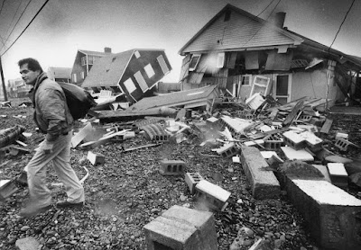
Damage from the "Perfect Storm" in Scituate, Massachusetts 
back in 1991.  Photo from the Boston Globe.
The weather geek in me is wowed by the current weather pattern because of its striking resemblance to this time of year as 1991.  

That was when the so-called "Perfect Storm" was battering New England and Canada, and an extreme unprecedented blizzard and intense cold was hammering the Midwest.

Before anybody panics, this won't be Death And Destruction week, at least not to the degree of 1991. There are enough differences between the set up in 1991 and the way things are arranged this week to spare the United States from storms as historic as those nearly three decades ago.  

The most famous piece of the 1991 puzzle was the Perfect Storm.  That storm was made famous by the book and subsequent movie about the sinking of the fishing boat Andrea Gail.   The Perfect Storm also caused a lot of coastal destruction from storm surges and massive waves in southeastern Canada and coastal New England and Mid-Atlantic States.

The Perfect storm became such a monster as Hurricane Grace merged with a powerful non-tropical storm off the coast of the Canadian Maritimes. 

In a similar vein, major Hurricane Epsilon developed rapidly far out in the Atlantic Ocean and is involved with a non-tropical storm.  At its peak last night it had maximum winds of 115 mph.  The main difference this time is Epsilon and its parent storm are further east, so it's not having nearly as much of an impact on the Northeast as the Perfect Storm.

The New England coast can expect some swells and maybe some minor splash over flooding from this, but nothing to get too scared about. The storm will really wind up in the North Atlantic, causing some incredibly rough seas up there. 

Within a few days of the Perfect Storm, at Halloween on on November 1, an incredible blizzard hit the upper Midwest, especially Minnesota.  More than two feet of snow socked Minneapolis, and much of the state was paralyzed for days. Duluth received 36.9 inches of snow. 

An even more incredible part of this storm was the cold that followed. Temperatures were in the minus teens in Iowa and in the 20s below zero in Minnesota. Many records were set for the coldest for so early in the season. 

The Halloween blizzard of 1991 in Minnesota during
an extreme weather pattern that year.

The weather pattern, though not as fierce for the United States as in 1991 still includes quite a bit of drama. 

Winter storm watches, warnings and advisories stretch along the northern tier of the United States from Washington State to Upper Michigan. 

That's an awful lot of real estate to simultaneously experiencing winter weather this early in the season. 

In the northern Rockies, temperatures in the northern Rockies are forecast to fall below zero later this week with highs only in the teens this weekend. Pretty wintry! 

Vermont was pretty much spared from the extremes in the autumn weirdness of 1991.  Little precipitation fell here. The weather turned somewhat chilly, but nothing that odd for this time of year.

This year's episode is looking wetter than in 1991, with frontal zones and storms expected to produce a soaking rain for Vermont for the first part of next week.  Still, I don't anticipate any extreme, wacko weather around here. 


Wednesday, October 21, 2020

WIndshield Wiper Weather Front Keeps Moving Back And Forth Over Vermont

Fading yellow leaves try to compete with the gloom 
over St. Albans, Vermont this morning. The state
has been in a weather battleground lately, creating lots of 
clouds and frequent rains. 
 You've probably noticed here in Vermont, especially the further northwest  you go, that we've had a lot of clouds and bouts of rain lately. The forecast calls for more of the same.  

We're in a classic weather battleground.  Off to the west, winter is on the march, unleashing cold air onto the northern Plains.  

There was a surprise snowstorm in part of Iowa two days ago. Another snowstorm, less of a surprise, but bigger, dumped more than six inches of snow on parts of Minnesota. Minneapolis had its second snowiest October day on record, with 7.4 inches. 

A third snowstorm has prompted winter storm watches from Montana, through parts of the Dakotas and Minnesota Thursday and Friday. 

Meanwhile, the Atlantic Ocean off the East Coast is unusually warm, and a toasty ridge of high pressure holds sway out there, just north of Hurricane Epsilon. (Don't worry, Epsilon is not headed toward the United States.

We're caught in the middle between the cold out west and the heat to the east. 

This being later in autumn, the cold air keeps trying to win out, sending cold fronts crashing in with bouts of showers and bursts of chilly air that don't last long.

That's because the warm air is fighting back, flinging those cold fronts back north as warm fronts. Then the cold tries again. On and on it goes. 

Basically, the same weather front keeps going back and forth over us.  One such set up hit last week before  a more decisive cold front came through Friday. 

This week is even more changeable, The front came north as a warm front Sunday, back south over us a cold front Monday, back to our north Monday night, then south through us again yesterday,and then back north today. 

That's why it's been windshield wipering back and forth between warm and humid-ish, and chilly and damp.  It's almost impossible to decide how to dress for the day, other than to bring an umbrella or rain jacket. 

And it goes on.  The front goes back south of us tonight, giving us a sunny break Thursday.  Then back north Friday, then south through us Saturday.  I think we're getting hit be the same cold/warm front almost a dozen times, at least it seems.

The chilly air wins out by Sunday.  But we're still near this battleground.  The weather front between the cold air to the west and the hot air to the east will set back up for the first part of next week. It'll take a position somewhere along the East Coast. Storms riding along this front will bring us even more rain. 

It might even start as a period of snow in the mountains Sunday night. 

This is all very gloomy, of course, because the sun has gotten scarce. But this has been a good month to continue easing the drought. The drought isn't over yet, but it is decaying with all these rain storms.

Rainfall for October will end up above normal for most of New England, including Vermont. 

We do know the cold air will eventually win out and the snows will really fly.  We just don't know when or to what extent.


Tuesday, October 20, 2020

Iowa Derecho Was Nation's Most Costly Thunderstorm

The derecho that swept through Iowa on August 10 turns out to be very likely the most costly thunderstorm event in United States history. 

Debris from the August derecho in Iowa was covered
in unseasonable snow on Monday. Photo via Twitter
 from Rebecca Kopelman @KopelmanWX 

You think of thunderstorms causing local damage, since they're usually relatively small in area. 

But this derecho was so strong and so widespread, it ended up causing at least $7.5 billion in damage, according to reports from the Washington Post and NPR.

Yes, I am still a little obsessed with this Iowa derecho because it was so unusual. The length of its path was long - about 770 miles - which is pretty lengthy but not outstanding for a derecho.

The remarkable part of this storm was how intense it was.  

Widespread areas had gusts in the 80 to 100 mph range, with a peak wind estimated at 140 mph.  In any given place in most of Iowa, the worst of the storm lasted a half hour or more, which is an awfully long time to have such strong winds blowing from thunderstorms.

No wonder the destruction was so great.  In Cedar Rapids, about 90 percent of homes and businesses had at least some damage.  Roughly 1,000 homes in Iowa were destroyed. 

The storm came at the worst time of year for crops, NPR notes. Corn was tall before the storm, making it easier for the winds to slam the corn stalks to the ground.  Had this storm occurred in the spring or early summer, the corn would have been shorter and more able to withstand the winds.

At this point, it looks like the Iowa derecho is so far the second most expensive weather disaster in the United States this year.  Only Hurricane Laura in Louisiana was worse, with estimated damages there at around $14 billion. 

The closest comparable derecho in terms of destruction I could find was one that extended from Ohio and Michigan to the Mid-Atlantic States in June, 2012.  That one caused about $2.9 billion in damage. 

In Iowa, the amount of debris from the derecho is so immense that a lot of it hasn't been removed yet. Big piles of wreckage line city streets in Cedar Rapids and elsewhere. 

To add insult to injury, an unexpectedly heavy and early season batch of snow squalls Monday dumped up to seven inches of snow on some of the areas most affected by the August 10 derecho. 


Monday, October 19, 2020

Colorado Burning: Wildfires Expand Again Amid Drought

Huge smoke plume erupts from a wildfire in Colorado
on Saturday. The wildfire season in Colorado should
be winding down by now. Not this year. 
Wildfires occur in Colorado almost every summer.  By mid-October, you expect them to be out, or at least dying down as winter rains and snows move into the state.  

Not this year, as high winds and continued drought keep sending flames up and down mountain slopes, and sometimes through neighborhoods.  There's no real sign of an end to all this. 

This past weekend was really rough.  To start with, the Cameron Peak Fire, as it's called, surged eastward, endangering more homes.  This is the largest wildfire in Colorado history.

It's burned more than 200,000 acres since starting on August 13. This massive, long lasting fire got tamped down a bit around September 9 as a rare bout of early season snow fell on it. Since then, however, it's been dry and windy, so the Cameron Peak Fire has raged on. 

Saturday was especially rough as a new fire, called the CalWood Fire, started Saturday and raced through the foothills around Boulder.  At least 23 homes burned. Probably more than that, actually, as people haven't been able to get in and assess everything yet. 

This fire had some extreme behavior. It's roiling smoke cloud created added high winds and featured funnel clouds of smoke as the fire roared from hill to hill. 

Yet another fire started Sunday northwest of Boulder, prompting further evacuations. 

The weather should improve later this week in Colorado, which could help control the fires, though it would take a lot of precipitation to stop them. Temperatures should generally be near or below normal in Colorado for the next 10 days or so, and some precipitation seems possible this coming weekend.

All of Colorado - and most of the West for that matter - is in drought. All of Colorado is in severe drought, with nearly 60 percent of the state in a the extreme drought category. 

As Colorado Public Radio reported in August, these types of hot, dry seasons will become more likely in that state and elsewhere in the west as climate change takes hold.

Hotter air dries things out faster than cooler conditions, and that was a factor this year.  As of August, Colorado was having its driest year on record and its 12th warmest. 

In the spring, the mountain snowpack was at or above normal in Colorado.  But it disappeared much, much more quickly than normal because of the hot conditions.  That, in turn, helped set the stage for the wildfires later in the year. 

The hot, dry weather that's becoming more frequent in Colorado is also creating longer fire seasons, which is why the current fires are raging well into the autumn this year. 

One climate researcher at Colorado State University is calling the whole situation "the new abnormal."

Colorado is just one example of how we're now seeing climate change play out in real time. 


Sunday, October 18, 2020

"Snoliage" In Parts Of Vermont Saturday; Wind, Rain To Keep Stripping Leave

Not everybody thinks snow is a great thing during foliage season.  

I took this snoliage photo two years ago in St. Albans, 
Vermont, but people throughout much of Vermont's 
Northeast Kingdom and higher elevations had a chance
to get their own "snoliage" photos Saturday morning.

But it is absolutely gorgeous. 

Especially during a fleeting moment when the sun comes out right after the snow. 

Which is what happened in parts of Vermont and New Hampshire Saturday when rain turned to snow in some high elevations, and in the Northeast Kingdom of Vermont and northern New Hampshire.

A number of photographers captured that fleeting moment when the sun lit up the snow and the foliage, just before that sun melted the snow. 

I missed this opportunity, since it didn't snow where I live in St. Albans, Vermont. But it was all nice to see on social media.  I'm reluctant to appropriate photos from social media, so go on Twitter or Instagram so search out snow photos from Vermont and New Hampshire from yesterday. 

Most places that got snow didn't receive much.  The reports in Vermont were mostly under two inches. The exceptions were the remote towns of Norton and Averill along the Canadian border in the Northeast Kingdom.  

Those towns received five or six inches of snow, as they shared in the heavier snow that socked northern New Hampshire.

The good news with the the storm, aside from the pretty pictures, is that the heaviest precipitation came down in the eastern half of Vermont and in New Hampshire. The lingering drought there was worse than in places further west, so this will help. 

More than an inch of rain fell in eastern Vermont, with a few places coming in close to two inches of precipitation. Danville, Vermont, for instance, logged 2.14 inches of rain. 

Western Vermont did OK, so that will help any lingering dryness there. Both Burlington, and my unofficial rain gauge in St. Albans, Vermont, collected right around three quarters of an inch of rain 

Though rainfall this month is running above normal, we still need more.  There are frequent chances this coming week, though rainfall isn't expected to be heavy.  Unfortunately, it looks like places east of the Green Mountains will get less than locations further west, but what are you going to do.

There won't be any real chances for more "snoliage" either.  It will be too warm for snow all week. Also the rain and expected gusty winds will strip most of the leaves from trees. We're heading into stick season, folks. 

Saturday, October 17, 2020

When Weather Disaster Strikes, Picking Up The Pieces Takes Forever, Unfortunately

Damage from a huge hailstorm in Calgary, Canada
lingers four months after the storm. It shows the slow
pace of recovery typical of big disasters.
Photo by Helen Pike/CBC 
 We see it over and over again.  

A big, devastating storm strikes, and the media swoop in and cover the destruction, the heartbreak and loss, and then move on. 

It makes it easy to forget that the aftermath, the effort to pick up the pieces, often takes years.  You wonder if it will ever get done. Sometimes it doesn't. 

One example is a hail storm that struck Calgary, Alberta, Canada four months ago. The storm caused $1.5 billion in damage and severely damaged thousands of homes. A thick barrage of tennis ball sized hail wrecked so many walls, windows and roofs. 

Now, with winter setting in, most of the damage is still not repaired. 

It takes time for insurance adjusters to settle claims.  Then, thousands of people all at once compete to hire a limited number of contractors to fix the damage. Good luck getting anything done within a reasonable amount of time. 

Now winter is settling into Calgary.  This being Canada, it can get awfully cold up there. It often gets below zero there each winter, and the coldest it's ever been in Calgary is 46 below.

And now you have a lot of houses with damaged windows, roofs, and siding. Which allows cold and moisture to enter these houses, causing added damage. 

Making matters worse, the Alberta provincial government has provided disaster relief for flooding from the storm, but not hail damage, according to the CBC.  Just an example of bureaucracy not helping matters. 

The Calgary hail storm, bad as it was, didn't come close to the biggest calamity a town or city could endure. 

There's plenty of for instances.  The town of Paradise, California was practically wiped off the map by a deadly wildfire in 2018.  The town isn't close to being rebuilt.  Lots of people in the area have PSTD, made worse by nearby wildfires this year that choked the air in Paradise with smoke and briefly threatened to cause new destruction in town. 

A month before Paradise was literally lost, the town of Mexico Beach, Florida was flattened by Category 5 Hurricane Michael.  This is another town that hasn't recovered and won't anytime soon.  

Mexico Beach still has no gas stations, and the bank just re-opened early this month.  The town has so far only gotten half the money it needs to get its infrastructure back and running, as television station WFSU reports. A few houses have been rebuilt, but Mexico Beach is still largely empty lots. 

Here in Vermont, it really took at least five years to pretty much fully get the Green Mountain State back up to snuff after the extreme floods of Tropical Storm Irene in 2011. 

The point of this post is to show that disasters are coming at a dizzying pace.  They dominate the news cycle for a day, a week, sometimes a month. Then we all forget, because the next catastrophe has hit. Meanwhile, the people in the earlier disaster zones are pretty much left to solve it on their own. 

I don't have a good solution here.  However, if the scientists are right, the pace of big weather disasters will continue to accelerate as the planet warms.  Which means more and more of us will find ourselves picking up the pieces and not sure if we have a decent future. 

Here's the CBC news piece that inspired today's post:


Friday, October 16, 2020

Glorious To Gloomy: That's Autumn In Vermont For Ya!

Gorgeous weather yesterday lit up the foliage around
my yard in St. Albans, Vermont and even made my
frosted and fading perennial beds look colorful
Thursday's weather in Vermont was as glorious as can be: Temperatures soared well into the 70s, and bright sunshine lit up the lingering fall foliage.  

Sure, it was windy in some places, especially the Champlain Valley, but who cares? It was gorgeous.

Autumn weather turns on a dime in New England, and sure enough, the character of today will be the polar opposite of Thursday. 

Expect it to be gray and dark, with occasional rain.  The air will stay chilly and damp all day.  Temperatures will stay stuck near 50 degrees all day. 

 We're rapidly heading into the cloudiest time of year, so expect more of this in the coming days and weeks.

A slow moving cold front came into Vermont last night, and is lingering in New England. Meanwhile, a storm system will move northward along the front.  This will keep the rain going, and it looks to be heavy at times in eastern Vermont, and into New Hampshire and Maine. 

That's a good thing, since the worst of this year's drought is in those neighborhoods. 

Recent rains have diminished the drought conditions somewhat in eastern Vermont, according to the latest U.S. Drought Monitor.  Things are steady in western Vermont, where it's not quite as dry to begin with. Today's rains will help a little more. 

We've actually gotten a little wetter to the point where the heaviest rain in eastern Vermont will probably cause streams and rivers to rise abruptly. I really doubt there will be any flooding to speak of, and even if there is it will be quite minor.  But at least the rivers are now able to respond to rain. Ground water has gotten a bit better, even if we still have a ways to go to bring that moisture up to reasonable levels. 

Since we're getting well into autumn now, the chances increase that some precipitation in Vermont would be snow, especially near the tail end of some storms.  Sure enough, the mountain summits in and around Vermont should see at least a couple inches of snow out of this.  Valley locations are safe from the snow. 

Although the sunshine will come back off and on over the next several days, the weather pattern is staying active, so expect more bouts with clouds and rain nearly every day through at least the next week.  

Tomorrow, Saturday, does look rather sunny in the afternoon after the early morning rain and mountain summit snow clear out. Don't expect those warm temperatures we had yesterday, though.  Daytime readings will stay in the relatively chilly 50s. 

Thursday, October 15, 2020

Another Global Heat Record In September; Disasters Pile Up, Too

Once again, more red than blue. September
globally was the warmest on record.
On a global basis, September was the world's hottest on record, according to the National Centers for Environmental Information.

If the above sentence seems familiar, it's because almost every month lately, we break a record for the hottest month, or score in the top two or three. 

Here's the official word from NCEI:

"The September 2020 global land and ocean surface temperature was the highest for September in the 141-year record at 1.75 F above the 20th century average of 59.0 F. This value surpassed the now second highest September temperature that took place in 2015 and 201 by 0.04 degrees."

The seven warmest Septembers on record have all occurred in the last seven years. The 10 warmest Septembers have happened since 2005. 

This was the 44th consecutive September and and 429th consecutive month of above normal global temperatures. That means if you're 35 years old or younger, you've never seen a month on a global basis that was cooler than average. 

The warmest places, relative to average, were Siberia, central and eastern Europe, western North America, central South America and Australia.

As always, a few areas were cooler than average, despite the global heat. But not by much. Greenland, parts of eastern North America, western Asia, the southern Indian Ocean and eastern Pacific Ocean, mostly near and off the west coast of South America.

That bit about the eastern Pacific is telling. It's a sign that a La Nina is under way.  La Ninas tend to cool the eastern Pacific and also suppress global temperatures a bit, too. That makes it rather remarkable that September broke the global heat record.

The opposite phenomenon, La Nino, features warmer than normal water in the eastern Pacific and tends to warm the world a bit. That's when you usually get monthly global heat records.

The past five years of repeated record global temperatures concern climate scientists James Hansen and Makiko Sato.

For the past 50 years or so, the world has warmed at a relatively steady clip of 0.18 degrees Celsius per decade. For the past five years or so, it's gone much faster than that rate.

The two scientists think that the abrupt change has something to do with atmospheric aerosols, which are tiny particles floating in the air. 

There are always such particles in the air, made up of a multitude of different types of material. Exactly what's going on with aerosols, and how that might be affecting climate trends, is not entirely clear. 

It might be that there's a decrease in the type of particles that block the sun and its heat. It's another topic scientists need to get a handle on.   

Serious damage in Louisiana from Hurricane Laura in 
August. It was one of 16 billion dollar disasters in
the United States so far this year. 

Meanwhile, expensive disasters continued to unfold during September. 

Jeff Masters, writing in Yale Climate Connections, says the United States this year has suffered 16 weather-related disasters costing $1 billion or more. 

That ties the record for the most in one year. It also doesn't include recent Hurricane Delta, which might also have cost $1 billion.  Plus, we have more than two months to go during which more big disasters might strike. 

The 16 disasters killed 188 people and caused a total of $46 billion in damage, Masters wrote.

There is an increasing trend in such disasters. A large part of it is that we're building more and bigger homes and businesses that are vulnerable to storms, wildfires and such.  Also, some of these disasters are getting more intense, and more capable of damage, in part because of climate change.  

Wednesday, October 14, 2020

A Windy, Sometimes Fiery Nation Today

All those red areas in today's National Weather Service map
are fire alert areas. The browns are high wind warnings or
advisories. Many of these areas are under both wind
and fire alerts. 
We here in Vermont got some more rain, as expected Wednesday, with some parts of eastern Vermont getting more than an inch. 

That's terrific, since the driest conditions around here have been in those parts of the Green Mountain State.  

It's also pretty calm out there today, which is an exception to what's going on in much of the nation. 

There's lots of wind today in the western two thirds of the United States, with vast areas under high wind warnings and wind advisories. 

Unfortunately, many of these areas are in drought. The combination of that dryness, the strong winds and low humidity is once again driving up the fire risk. 

The nation's fire season just doesn't seem to want to end. 

The areas most at risk for dangerous wildfire conditions today are northern California (again!), the northern Rockies and a vast area of the northern and central Plains. 

You wouldn't think there's much to burn in the Plains, but there's a lot of grassland and dried out crops that can easily catch fire.  These blazes can be dangerous. 

For instance, rangeland fires in Oklahoma back in 2018 killed at least two people and destroyed several dozen homes.  

The Plains will trend toward cooler and in some places somewhat wetter conditions over the next week, which should improve things, at least temporarily.

Out on the West Coast, it's still looking grim for awhile yet. Below normal rainfall is likely to continue out there for at least the next two weeks. No rain is forecast anywhere in California for the next two weeks. 

It doesn't usually rain in southern California this time of year anyway. Santa Ana winds expected near Los Angeles will raise the fire risk for much of the rest of this week. 

Northern California usually starts to see the start of the winter rainy season about now.  So far, no luck. 

Back here in the New England, recent rains haven't entire erased the drought, but at least the forests are now too wet to support any real brush or woodland fires.  

Tuesday, October 13, 2020

The New England Rain Derby, A Derecho, And Snow?

Fall colors pop in my St. Albans, Vermont yard amid dark
clouds and rain today.
 As of mid-morning, it was raining outside by hacienda in St. Albans, Vermont, another installment of drought relieving rain coming down. 

Though it looks like rainfall won't be quite as heavy as originally forecast, it will be another slight blow to the lingering drought over New England. 

It turns out some of the best moisture will go by well to Vermont's east, but we're still looking at as much as a half inch of rain in western Vermont today, with around three quarters of an inch east of the Green Mountains. 

That's respectable, if not overwhelming.

For fans of rain, there's more potential good news.  Current forecasts have a strong, slow moving cold front moving through Friday, with a storm forming along it and moving northward through New England. 

There's potential, at least, for this storm to grab a nice slug of moisture and dump a lot of rain on much of New England, including Vermont.  If all goes well - that's still a big if - there could easily be one to two inches of rain with the Friday/Saturday storm. 

It looks like the Friday and Saturday event will be a chilly one as well. Today is cold and damp under the rain, then it warms up to perhaps near 70 again on Thursday, before temperatures crash again. 

The end of the week storm might prove to be the first substantial snowfall of the season on the highest elevations on Vermont, New York and New Hampshire. Several inches of snow could accumulate on the summits. 

The valleys are safe with this one. It'll just be a cold rain. 

Looking further ahead, three's a shot of another rainfall come Tuesday or Wednesday. We're on pace to have a wetter than normal October, which is just what the doctor ordered to help erase the New England summer and early autumn drought 

A DERECHO?!

As noted in earlier posts, we had two rare outbreaks of severe thunderstorms in the North Country, one last Wednesday, the other on Saturday. Those two events were definitely odd for October.

I had thought that the event last Wednesday was not a derecho, but it turns out, upon further analysis, it was.

A derecho is defined as a concentrated swath of severe thunderstorm damage extending at least 240 miles in length.  It must include consistent gusts of 58 mph or greater along its entire path. 

A billboard was bent over in strong winds during
last week's derecho in Johnsville, NY.
Photo via NWS Albany.

The event from October 7 has been officially declared a derecho by NOAA's Storm Prediction Center. It extended more than 320 miles from Lake Ontario to Cape Cod. 

 (There were a couple severe storm reports in northern and central Vermont that day, but that was outside the derecho's path. Far southern Vermont WAS in the path of the derecho). 

This derecho produced one brief tornado in Canajoharie, New York, and numerous gusts over 60 mph through central New York and southern and central New England. Up to half a million homes and businesses lost power. 

Most severe thunderstorms have damaging gusts that last only a few minutes. Derecho winds often last a bit longer. This one featured strong gusts lasting up to 15 minutes. 

Derechos are rare in New England, especially this time of year. About 70 percent of all derechos in the United States happen between May and August.  New England averages one derecho once every four years. 

As destructive as this month's New York and New England derecho was, it was far less intense than the well-publicized, extreme derecho that struck Iowa on August 10.  That storm caused at least $4 billion in damage and destroyed or severely damaged 8,000 homes. Almost all homes in Cedar Rapids, Iowa and within 75 miles of that city had at least some damage. About 14 million acres of farmland was damaged.