Showing posts with label Mississippi. Show all posts

Thursday, February 12, 2026

Is Climate Change Shifting Where Dangerous Ice Storms Set Up?

Lewis County, Tennessee after the late January ice storm
Research suggests that climate change might be making
ice storms more common in the South, but more research
is needed to confirm that. Photo from Tennessee 
Valley Weather/Facebook
Are ice storms moving to different and potentially more dangerous places? 

Some scientists are beginning to think so, and that could lead to more frozen disasters like the one that blasted Mississippi, Tennessee and other southern states in late January

 Drawing on long term records, computer modeling and new measurement, scientists in Texas concluded that a warming world isn't making freezing rain go away. It's just changing where it falls and when in the winter it occurs. "

Zong-Liang Yang, an earth systems scientist the University of Texas at Austin and postdoctoral researcher Chenxi Hu looked into this. According to science.org:

"To see how these changes might be playing out in the ground, Yang and Hu turned to the National Oceanic and Atmospheric Administrations Storm Events Database, which compiles weather phenomena reported by individuals and vetted by the National Weather Service. 

When the researchers analyzed county-level  records from 1996 to 2025, they saw an emerging trend: More events along a band from eastern Texas to western Pennsylvania, as well as along the Appalachian Mountains, where low, cold air can get trapped. The timing of freezing ran events also shifted from December to February."

The locations Yang described here almost exactly match the zone affected by the disastrous late January ice storm,. 

Freezing rain is thankfully a bit hard to come by compared to other forms of precipitation. Snow needs to change to rain on the way down. Those raindrops must then encounter subfreezing air just before hitting the ground as liquid, which freezes into a glaze of ice upon impact.

If the cold layer near the ground is too thick, the rain will freeze into sleet, or little balls of ice on the way down. Sleet is a pain in the butt, of course, but at least it doesn't pull down trees and power lines. 

Also, freezing rain is often transitory. It'll hit briefly as an interlude between the time snow goes over to rain as temperatures warm. The warm/cold battle of air masses must more or less stay put to create a dangerous ice storm. 

Not everyone is buying the idea that climate change is shifting the places where ice storms are most likely - at least not yet

Esther Mullens, a climatologist at the University of Florida, told science.org that it still could be just natural variations that move ice storms around, or create trends in ice storms.

In 2025, Mullens looked at ice storms over the past 80 years and concluded that natural climate variations might explain the uptick in southern freezing rain storms. She concedes it could be that the jet stream is getting wavier than it used to be. 

A wavier jet stream is more likely to bring Arctic air blasts further south, which could increase the chances of freeing rain. But climatologists are still debating whether climate change is seriously messing with the jet stream like that. 

Still, there is a pretty compelling argument that the warming of the Arctic might be creating a wavier jet stream.  A wavier jet stream is more likely to create the right conditions for freezing rain than a flat west to east upper air flow.  

Another potential effect of climate change is it might affect how heavy the precipitation is. Even with a warmer world, it still very often gets below freezing in the mid-latitudes of the northern hemisphere during the winter. 

A warmer world, though, is a wetter world.  A hotter atmosphere can hold more water that a cooler one. Storms like the one that hit in January draw moisture from warmer places like the southern Gulf of Mexico, the Atlantic Ocean or Caribbean.  That moisture slams into the cold air further north to fall as snow, sleet, freezing rain or a combination of all three.

Since the January storm was wetter than it would have been before climate change began in earnest, it was probably able to dump more ice and snow on the eastern U.S. that the same storm would have a generation or two ago.

The heavier the freezing rain, the more weight you get on trees and power lines. Snow in some storms might be deeper than it otherwise might be. We have anecdotal evidence of that right her in Vermont.Burlington's weather data goes all the way back to the late 1880s. Yet, 11 of the city's 20 biggest snowstorms all came in the past quarter century. 

You get the point. Winter storms can be counterintuitively worse in our era of climate change.  

Climate change can even make lake effect snowstorms worse. Lakes would be slower to freeze during warmer winters, so they'd have more opportunity to dump heavy snow downwind of the lakes on the days it does turn cold.

The data the Texas researchers used was based on reports by humans, who sometimes under-report or over-report the amount of ice during a freezing rain event. 

NOAA is working on a new tool that uses radar, rain gauges and an ice model to map freezing rain in real time, science.org says. 

The new tool would make an analysis like what Yang and Hu did more accurate, as we'd have more precise information on how much ice accumulated and where. 

All this shows that climate change isn't just about heat waves and warmer winters. Under the right conditions the warming world can make the rare wintry intrusions much worse. Worse, even, than what your grandparents remember when they walked through feet of snow to and from school, uphill both ways.   

Sunday, February 8, 2026

It's Not Just Minneapolis: Noem Continues To Botch Her FEMA/Disaster Role, Too

Ice storm damage in Oxford, Mississippi last month.
While understandable ire goes toward Kristi Noem
and her "creative" approach to immigration
enforcement, she's also getting terrible marks
dealing with natural disasters in the U.S;.
Everybody is hating on U.S. Homeland Security Secretary  Kristi "ICE Barbie" Noem. For good reason 

ICE Barbie's oversight of ICE and the U.S Border Patrol is obviously gaining the most headlines, due to what is basically the invasion of Minnesota and exceptionally cruel and unlawful ICE arrests across the U.S. 

The outrage reached a crescendo in late January with ICE Barbie's outrageous remarks ad reponse about two people in Minneapolis who were killed by federal immigration agents. 

Within hours of Alex Pretti's  death, both Noem and the equally odious White House Deputy Chief of Staff Stephen Miller described him as a domestic terrorist who "wanted to do maximum damage and massacre law enforcement."

Never mind that we all saw the video taken by witnesses of Pretti's murder with our own eyes. 

 "Imagine how they lie when there's no evidence to contradict them," Jon Stewart recently said, "And maybe that, more than anything, explains why Alex Pretti really was a threat. Because he was brandishing a weapon: A handheld, aluminum 1080p, 60fps weapon of mass illumination, " referring to Pretti's camera phone. 

I really do think this administration's greatest fear is camera phones. Hard to spin bull all over the place when there's plenty of footage to debunk their lies.

It's pretty clear Noem should not be the U.S. Homeland Security Secretary. But MAGA loves cruelty, incompetence and grift, so here we are.  Noem's incompetence extends to where the cameras aren't: In her offices, dealing -  or in her case not dealing - with disaster assistance. 

Sen. Thom Tillis, R-NC recently had the following to say about Noem's work on disaster relief:

"Another part of the Secretary of Homeland Security job is disaster response and I cannot tell you enough how incompetent she is on that score as well. The data clearly shows that something is seriously wrong here. 

Under Secretary Noem's lack of leadership, FEMA has invented an entirely new set of bureaucracies, the likes of which I've never seen. And I'm in a state that deals with a disaster almost every season. 

Under Noem's leadership, which is supposed to be more efficient, more effective and more responsive to the disaster in western North Carolina and the other states that were affected look like the EKG of someone who's having a heart attack. She needs to get out of the C-suite."

Meanwhile, as Inside Climate News reports, disaster victims from across the United States are pleading with Congress to restore FEMA as an independent agency, one that would be no longer under the politicized leacdership of ICE Barbie.

The disaster victims and advocates say ever since FEMA fell under the umbrella of the Department of Homeland Security, it has become more slower, more restrictive e and less accountable. 

FEMA was formed in 1979 and until 2003 reported directly to the President and Congress, But FEMA wss consolidated under the Department of Homeland Security after the 9/11 terror attack.

The disaster survivor group says FEMA is held hostage inside an agency that's focused on violent immigration enforcement. Disaster relief has at best become an afterthought. 

LATEST DISASTER

ICE Barbie did appear to want to at least pretend she was gearing up for the immense winter storm that hit the U.S. on the weekend of January 24-25. 

She waltzed into the FEMA headquarters just before the storm to give a rah-rah little pep talk. 

"I was shocked she showed up after all the shit we've been put through and what she's said," one FEMA official told CNN, adding that you could hear a pin drop in the center that day."

CNN continues:

"In the case many FEMA insiders were heartened by Noem and her team's sudden show of support, but aren't convinced the heavy-handed overhaul and downsizing are over. 'I doubt that this is permanent. I hope it is, but I doubt it,' one high-ranking official said."

More likely than not, ICE Barbie's appearance at the FEMA headquarters was just window dressing. In all the news stories about the immense ice and snow storm that caused so damage and misery on January 23-26, I hear very little about FEMA involvement in what was truly a huge disaster. 

A FEMA help page did appear last week, and Donald Trump has declared federal disaster areas in Mississippi and Tennessee. And some federal help arrived in some of the hardest hit states

But I didn't really see boots on the ground FEMA help like we saw in other disasters during the Biden administration. Vermont was crawling with FEMA personnel during and after the big summer floods of 2023 and 2024, for instance . 

FEMA in January had been poised to terminate waves of disaster-specific workers in waves, according to the Washington Post. 

However, just before the big winter storm in late January, DHS paused the FEMA firings. Bad PR to get rid of the help when it's really needed, I guess.  

I'm not optimistic about victims of last month's winter storm given the handling of other disasters over the past year. 

FEMA under Ice Barbie have faltered with big disasters like the aftermath of Helene. That storm hit in 2024 and North Carolina has only gotten a fraction of the requested federal aid.ON

Only about one fifth of applicants in Kerr County, Texas,  hardest hit by last July's extreme flooding, have been deemed eligible for financial help so far.

Additional big calamities are almost certainly in the pipeline. Tornado season will ramp up in a month or two. The western U.S is deep in drought, which makes me and a lot of other people worried about the summer fire season. 

Last year, the U.S. got lucky with no hurricane landfalls. Can we do two in a row? Fingers crossed, but it's a long shot. 

Unfortunately, I've said this before and I'll say it again. Anyone who gets nailed by a natural or climate disaster under this administration is on their own. 


Thursday, January 29, 2026

Hundreds Of Trucks And Cars Stuck On Ice-Locked Mississippi Interstate Amid Widespread Southern Ice Storm Power Outages

Missouri Department of Transportation traffic cam image
from this afternoon shows I-269 in the northern part of
the state still covered in ice and truck traffic
still backed up of miles. This nearly four days
after the freezing rain stopped falling. 
The Great Ice Storm  of 2026 in the southern United States continues to wreak havoc, days after the icy rains and snow ended. 

There's been dozens of deaths associated by the storm. By one count, 111 people have perished from either direct or indirect effects of the storm and cold wave. causes directly and directly connected to the storm and cold weather.  

The trouble now is it so far not warmed up after freezing rain stopped falling. Though some of the ice has melted from all those sagging trees, many road and highways contain thick, stubborn layers of ice. 

This includes major routes like Interstate 22 and Interstate 55, along with other main roads across northern Mississippi.

The freezing rain might have ended by this past Sunday night. But on Wednesday, the highways in northern Mississippi and parts of Tennessee and Louisiana were still thick sheets of ice. Sunshine that tried to thaw the ice and truck tires left ruts and holes in the highway ice.  

Then it froze again at night, making things even worse than before. For some reason, the Mississippi Department of Transportation did not close the highways until Wednesday afternoon. By then, it was too late. Tractor trailers and some cars were backed up for miles. People were stranded out there for as much as 24 hours. Sometimes more. All in temperatures far below freezing at night. 

 "I've been here since yesterday (Tuesday) about 4:30 p.m.  I haven't moved an inch," truck driver Lee Roy Thomas told ABC24 in Memphis Wednesday afternoon. 

A man from Wisconsin who was stranded on Interstate 22 in Mississippi told WREG: "I tried calling the Mississippi State Patrol all they would do is, there would be a bushy signal and they would hang up after four rings. I must have made half a dozen attempts at that. We were always waiting for someone to come by and check on us but nobody came by. Nobody checked on us."

One truck driver said that when trucks begin to inch forward, they slide sideways because it is so slippery. 

Drone video showed mile after mile of tractor trailer trucks just sitting there, not moving on Wednesday along Interstate 55.

I'm wondering why they didn't shut down these jammed up Interstate highways last weekend and kept them closed until the ice melted, or it could be bulldozed from the roads.  That would have caused huge disruptions, but probably not something as severe as those hundreds of people stuck out there in their vehicles. 

On Wednesday, Mississippi Department of Transportation finally did close down parts of Interstate 55 and Interstate 22 so ice could be cleared from the roads. Hopefully enough so that vehicles could get through reasonably enough.

MDOT also sent in plows Wednesday afternoon, but warned that any ice the sun melted during the day would freeze again at night. The National Guard and more MDOT trucks have been brought in to help clear the highways. However, as the sun set Wednesday, the two major interstates remained at a near-standstill. 

A special weather statement from the National Weather Service office in Memphis this morning urging no travel yet. The statement said main highways remain quite dangerous and most secondary roads across much of Mississippi and Tennessee are pretty much impassable still.

Some thawing was going on in northern Mississippi today as temperatures rise into the mid-40s, but that will not be enough to melt all the ice. An intense new cold snap will drop temperatures back below freezing tonight, and no real thawing is expected until at least Monday. 

Meanwhile, troubles kept popping up in hard-hit Tennessee as well.  

Ten people have died in Tennessee so far as a result of the storm. Residents are worried about more deaths as power remains out in many areas. Those fears are heightened by the prospect of a new cold snap coming in. Temperatures are forecast to drop into the single digits Saturday night after highs only near 20 degrees. 

As of this afternoon, more than 300,000 homes and businesses in the South remain without power. That includes nearly 100,000 customers each in Tennessee and Mississippi and more than 50,000 in Louisiana. 

In Nashville, elderly and disabled residents in a 12 story apartment building have had no heat or elevators for days and are running out of food. Fire crews evacuated some of the residents from the building on Wednesday. 

Videos:

News report on the highway situation in Mississippi from ABC2  in Memphis. Click on this link to view, or if you see the image below, click on that. 


Drone video shows mile and mile after mile of tractor trailer trucks just sitting on the ice along Interstate 55 in northern Mississippi. Again, click on this link, or click on the link below if it is visible.


Tuesday, January 27, 2026

Death Toll Rising From Winter Storm; Stubborn Deep Cold Raising The Stakes

The city of Oxford, Mississippi continues to post
photos of the ice storm destruction. Another example.

The death toll from the massive winter storm has risen to at least 34 in 14 states as the severe lingering effects of the snow and ice barrage continues to threaten more lives. 

As of mid-morning today, more than a half million homes and businesses remained without power, mainly in Louisiana, Mississippi and Tennessee. This, as temperatures reached record cold levels in the region this morning. 

In devastated northern Mississippi, temperatures are forecast to rise into the still-colder than average low 40s. At least that will melt some of the us. But a new, intense cold snap is set to hit by the end of the week, sending overnight temperatures back down into the single digits. 

Ice storm damage in Mississippi was even worse than in a historic 1994 storm. In 1994, it took 23 days for power to be fully restored. Officials said modernization could somewhat shorten the repair timeline this time, but probably not by all that much. 

In Tennessee, Nashville residents were told some parts of the city could remain without power for a week. Outlying areas will probably wait even longer. 

While the electricity is off in and around Nashville, the frigid weather continues, which is bad news for the thousands of people shivering without heat. High temperatures in Nashville should only reach the 20s and 30s through next Monday. This is a city where afternoon temperatures are normally around 50 degrees this time of year. 

Later on, the question of where to put the debris from millions of shattered trees in hundreds of communities in the South.  Right now, mountains of tree debris lines roads and streets. In some of the hardest hit cities, it looked like nearly every tree sustained at least a little damage. A lot of those trees are entirely destroyed. 

Roads in northern Mississippi are still coated in
thick layers of ice and snow even
though the storm ended late Sunday. 
They're not equipped to remove snow and
the thaws that usually follow winter storms
in the region have failed to arrive.
North of the ice zone, people are still clearing snow from a massive area from New Mexico to Maine and Canada. 

On Monday. 56 percent of the Lower 48 of the United States was covered in snow. At least a foot of snow fell in 18 states, including here in Vermont. Toronto, Canada endured its largest single day snowfall with about 22 inches of new snow. 

Travel problems continue to reverberate even after the storm has passed. 

American Airlines said this was their most disruptive storm in the company's 100-year history. American canceled 9,000 flights in the storm.  More cancelations and delays are possible over the next couple of days. 

Flight Aware showed about 2,300 flight canceled today, even after the storm has passed. Lingering ice and snow on the ground, and the disarray caused by the tens of thousands of cancellations during the actual storm, are helping to cause the problem.

In much of the South, highways are today still covered by thick layers of snow and ice. They don't have the equipment down there to remove all that ice. Usually, southerners wait for it to melt. Normally the melt doesn't' take long. This time, it is. 

The weird, extended Arctic weather is affecting most places east of the Rockies. 

Usually - at least in recent years and decades -  a severe winter cold wave lasts only a few days, and then it's largely over.   

This time, the frigid air is staying put. 

In Minneapolis, all but one of the past 11 days have gotten below zero. The next above zero daily low temperature is not expected until this coming Sunday.   

The cold weather pattern is forecast to last well into February. New York City's longest streak of consecutive below freezing days is 16, set in 1961. Given the forecasts, that record could be broken. 

Even Florida is enduring the chill. They've already had a couple hard freezes this winter and another is due tonight. Another, strong cold wave is forecast later this week. Temperatures could get down into the low and mid 20s around Orland and mid-30s as far south as Miami. 

Even worse, a nor'easter is expected to form off the East Coast. It's still unclear whether the storm will come close enough to shore to cause a blizzard. But even if the storm misses, it's almost certain to reinforce the cold air over the eastern United States.  


Tuesday, March 25, 2025

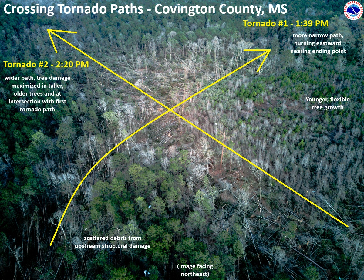
Two Weird Tornados Hit The Same Spot In Mississippi Within 41 Minutes. One Of Many Odd Tornado Stories

Aerial photo and schematic from the Jackson, Mississippi
National Weather Service office showing how two
tornadoes crossed paths within 41 minutes of
each other earlier this month. 
When there's a large tornado outbreak in the United States, you're almost guaranteed to hear odd stories about the behavior of at least some of those twisters. 

So it was with the swarm of tornadoes that hit on March 14-15.  So far, there have been at least 114 confirmed tornadoes with this outbreak, easily the biggest so far this year. 

Of course, we have at least one weird story about this outbreak. As the Washington Post reports:

"In western Covington County, home too 18,059 people, a pair of tornadoes left a crosscrossing path of damage southwest of the town of Collins, the county seat, in an area just north of Spring Hill School Road.

"......the first one, a dying EF4 that had begun in northern Louisiana, hit the zone around 1:39 p.m. central time. By that point, it had covered more than 67 miles and been on the ground for 1 hour and 22 minutes. 

Then, at 2:30 p.m, and EF2 tornado hit the same spot."

That had to be a pretty terrifying afternoon in Covington County. 

 The explanation, according to WaPo:

"Sometimes the most favorable conditions for tornado formation and maintenance exist in a small zone. When the storms pass through that sweet spot, they can spawn significant long-track tornadoes in rapid succession."

It is weird for two tornadoes to go in two different directions within the same hour, but it can happen.

My guess - and it really is just a guess - is the first one, ahead of a cold front, was associated with a supercell, which typical run southwest to northeast ahead of such a weather system.

The second one hit when the cold front was closer, and the inflow from the front might have helped the second twister to move southeast to northwest, toward the front. 

Luckily, the two tornadoes intersected in a forested area. Though both caused damage, at least nobody's house got hit twice.

OTHER TORNADO ODDITIES 

There have been other examples of large tornadoes crossing paths on the same day, or coming close to it.  This is most common in very large or super outbreaks of tornadoes.

During the famous April 3, 1974 super outbreak of tornadoes, two intense tornadoes passed in close succession  southeast of Flintville, a town in southern Tennessee.

On April 12, 2020, a deadly EF-4 passed just south of Bassfield, Mississippi, followed by an EF-3 that afternoon just north of town. 

There are certain unlucky communities that have been repeated hit by horrible tornadoes. Tanner Crossroads, Alabama was hit by two EF-5 tornadoes on the same day  in that big 1974 tornado outbreak. 

Then in the next big tornado on April 27, 2011, another EF-5 tornado crashed through Tanner Crossroads. It's the only U.S. town known to have been hit by three EF-5 tornadoes. 

EF5's are the worst possible tornado, with winds of over 200 mph.  This type of tornado sweeps houses away completely and pulverizes them. Unless you are in a tornado shelter or a very protected basement, you would not survive such a twister. 

There's also the unlucky city of Moore, Oklahoma, which has been hit by more than 20 tornadoes since 1961. Two of them were EF-5s and two others were EF-4s, the second strongest category of twister.

We have plenty of other examples of supremely unlucky towns in Tornado Alley

UNLUCKY PEOPLE

In Paragould, Arkansas, two tornadoes within less than a year of each other had crisscrossing paths that wrecked the same small group of houses in the Club View Estates neighborhood. 

One of the homes, belonging to the Drope family, was damaged last May 26 in a tornado.  They weren't able to move back in until a few months later. Then, on March 15, yet another tornado struck the same house, pretty much destroying it. .

This was actually the third time this family endured a tornado. A decade ago, they lived about ten miles up the road from where the remains of their current house is now.  That former home when they lived there was also damaged by a tornado. 

Just this past weekend, Rolling Fork, Mississippi was hit by a tornado. This one could have been worse. It caused some damage, but didn't hit the middle of town, and its winds were "only" about 100 mph.  Bad, but not as bad as it could have been

But Rolling Fork residents are spooked by tornadoes, especially if they hit on March 23, like this one did. It was the second anniversary of and EF-4 that struck the town, killing 17 people and leveling most of the community. 

By the way, the 2023 tornado might have been an EF-5, the worst kind, depending on how you measured it. I had a post on March 24 explaining some quirks in measuring these monster twisters. 

Single tornadoes, or groups of tornadoes in one town can be particularly terrifying. In May, 2007, an EF-5 tornado destroyed Greensburg, Kansas. Then its path performed a loop, crossing its own path and repeating the damage just north of where it had just demolished Greensburg. 

UNLUCKY YEARS

Then there are unlucky years, in which strong tornadoes hit big population centers repeatedly instead of mostly staying in rural areas. The year 1953 comes to mind. It was the only year known to have seen five F5 tornadoes until 1974, when seven such tornadoes hit in just the one Super Outbreak.

Not the Midwest, but a Midwest-
style EF-4 tornado pictured here
struck Worcester, Massachusetts
of all places in 1953, killing 94
and injuring 1,300
The year 1953 featured massive tornadoes hitting larger cities. On May 11, 1953, a huge twister hit downtown Waco, Texas, killing 114 people and injuring 597.

Barely a month later, on June 8, 1953, a F5 tornado hit the Flint, Michigan and surrounding towns killing 116 people and injuring 897. 

The next day, the same weather system move into New England, spawning an F4 tornado in Worcester, Massachusetts and nearby towns, ending the lives of 94 people and injuring 1,300,

More recently, we had the year 2011, which brought the super outbreak of tornadoes on April 26-28 that spun off 360 tornadoes from Texas to New York. The outbreak focused the worst of its wrath on Mississippi and Alabama, which were raked by numerous intense tornadoes. This outbreak killed 321 people. 

Then, less than a month later, an EF-5 tornado struck Joplin, Missouri on May 22. That massive storm killed 161 and destroyed much of the city. 

In total, between those two tornado outbreaks and others, 553 people lost their lives in twister during 2011.     

LATEST ODDITY

Tomorrow, a severe storm outbreak with large hail and even potential tornadoes is forecast in (check notes) an area of the Pacific Northwest encompassing Portland, Oregon and Seattle, Washington, among other cities.

Such an outbreak of severe weather is extremely rare in the part of the nation, but there you go. 

The same storm system threatens to cause a new tornado outbreak in the Midwest, Gulf Coast and Southeast Sunday and Monday. 

Sunday, December 29, 2024

As Expected, Tornadoes, Storms Spread Havoc Across The South, Caps An Extraordinary U.S, Tornado Year

Screen grab from Storm Chasing Channel video of
a tornado shredding trees Saturday in Mississippi
 At least two people died and damage is widespread from Texas to the Carolinas as the widely forecast Saturday severe weather outbreak unfortunately materialized.  

As of this morning there were at least 41 reports of tornadoes, mostly across eastern Texas, Louisiana, Mississippi and Alabama.

One person died in a tornado south of Houston, and a likely tornado claimed another life in Mississippi. 

Video showed a large tornado near Bude, Mississippi that unroofed several homes. Another video by the Storm Chasing Channel's Scott Peake shows the same tornado crossing a highway and shredding trees around a parked pickup truck. 

A likely tornado hit downtown Athens, Alabama overnight, tearing the roof off a court house and spreading debris through the streets. 

The storms moved into the Carolinas Sunday morning.

Flash flooding hit parts of western North Carolina early today in an area still reeling from the extreme floods from Hurricane Helene in September. This morning's flooding wasn't remotely as bad as that, but this region doesn't need more bad weather news. 

Up to four inches of rain fell in some of the steep terrain in those North Carolina mountains. 

During the busiest travel time of the year, storms were mostly responsible for 15,000 canceled or delayed flights over the weekend, according to FlightAware.  Most of the airports where the delays and cancellation originated were in the path of the southern storms. 

After the severe storms end later today, forecasters say there's little chance of additional widespread severe storms and tornadoes for at least a week and probably more, as colder air floods into much of the United States. 

A cold air funnel begins to form over St. Albans, Vermont
in a non-severe thunderstorm on June 9.  This was a type of
spin that is not associated with tornadic thunderstorms
and these tend not to be dangerous.

This year has been quite a year for tornadoes in the U.S. Through November, no fewer than 1,762 tornadoes were confirmed, which is the highest number since the epic twister year of 2004.  That year, 1,813 tornadoes were reported in the U.S. 

The number of death in tornadoes this year was 52, which is bad, but pretty low considering how many tornadoes spun up, and how many of them were pretty strong. 

For comparison, there were 83 U.S. tornado deaths in 2023, with 1,321 twisters being reported that year. 

Of the 24 weather and climate disasters in the U.S. this year that cost over $1 billion in damage, six were tornado outbreaks and a handful of others included some tornadoes in the mix.

NBC News reports one odd note about 2024 tornadoes, and that's the propensity for strong tornadoes with landfalling hurricanes.

Most hurricanes that make landfall in the U.S. do spin off some twisters, but most of those are relatively weak with top winds of up to 110 mph. Fewer than 1 percent of tornadoes associated with hurricanes have an EF-3 rating, which means destructive winds of 136 mph or more. 

But four of the five hurricanes that made landfall in the U.S. this year produced EF-3 tornadoes. Hurricane Milton, which hit Florida in October, sent a swarm of dozens of tornadoes through the state. 

This year also continued a trend toward more eastern tornadoes. True, the traditional "tornado alley" in states like Texas, Oklahoma and Nebraska were hit hard, but there were areas of pretty weird activity in the Northeast. 

New York had 32 tornadoes in 2024, breaking the single-year record for twisters of 25, set in 1992.

Right here in Vermont, there were no confirmed tornadoes in 2024, but some close misses. On June 23, tornado warnings were issued in parts of central Vermont due to rotating thunderstorms and reported wall clouds, but no confirmed twisters touched down in the Green Mountain State.

There was a tornado that day in Dublin, New Hampshire, about ten miles east of the Vermont border. 

On July 10, a tornado dissipated in New York state not far from the Vermont border, and a funnel cloud was spotted over Bridport. 

A tornado struck Lyme, New Hampshire on July 16, and its path started just a couple miles east of the Vermont border.  

Saturday, December 28, 2024

Dangerous Tornado Outbreak Lurks In Southern United States Today

There's a risk of tornadoes, some strong and long lasting
in the South today and tonight. The greatest risk is in
the orange and red zones of this map. 
 A year-end tornado outbreak seems like it's about to blossom in the South today, throwing one more potential disaster as a United States to close a year that brought us far too many destructive storms.  

NOAA's Storm Prediction Center says most of the Gulf Coast states from eastern Texas to Georgia, and as far north as Tennessee are under the gun today.  The most threatened area is in central Louisiana and southern Mississippi, 

The bad weather was getting off to an ominously early start. At least five tornado reports came in from right along the Gulf Coast in Alabama and Mississippi yesterday.

Already as of mid-morning, a tornado watch has been issued for most of Louisiana, along with far eastern Texas and southwestern Mississippi.  A smattering of tornado warnings have already been issued in Louisiana, and severe thunderstorm watch is added to the mix in northeast Texas and southwest Arkansas.

It's only going to get worse as the day goes on, apparently. 

There is enough spin in the atmosphere to create the risk of a few isolated twisters this morning where there's that tornado watch. That there's already a small risk before the main show arrives feels ominous to me, like all hell might break loose this afternoon.

We have no guarantee that will happen of course. But forecasters do say that this afternoon, that same area will see dramatically worse atmospheric condition.  

THE SETUP

A strengthening storm will pass north and west of the main tornado risk area later today and tonight, dragging a cold front towards the region.  The cold front should contain lines of severe thunderstorms with some exceptionally strong winds and some embedded tornadoes.

Worse, in the warm, humid air ahead of the cold front, powerful, rotating supercell thunderstorms are expected.  The changing wind speeds and direction with height near these storms could help them produce strong, cycling tornadoes. 

That means a long lasting supercell would put down a strong tornado that would blast through a region for several miles. Then it would lift, only to drop another intense tornado and so on and so forth. 

That's the kind of storm that produced a series of tornadoes in and near Kentucky in December, 2021 including one that virtually destroyed the small city of Mayfield. 

If this type of storm happens with this episode, a lot of it would happen at night, just as it did in December, 2021

These tornadic storms are especially dangerous at night, since people are not awake to receive warnings. Also, despite warnings on TV and weather radios, human nature, being what it is, makes people want to rely on visual cues that a tornado is coming. 

You don't have those visual cues at night. So people might not take shelter until it's too late.

For now, there's a moderate risk of tornadoes in parts of the South, which is the second highest of a five point alert level.  The Storm Prediction Center considered raising the alert level to the highest level, which is rare for winter, but there's still a little uncertainty about how the storms will take shape. 

Of course, as of this morning, we don't yet know how many tornadoes we'll see, or how strong that might be. We also don't know whether they'll blast through populated areas, or remain relatively harmlessly over open fields or in dense southern forests. 

Tomorrow the tornado and severe weather threat will move into the Southeastern U.S, with areas from Georgia to southern Virginia at risk.

WINTER TORNADOES

Spring and early summer are the peak times for tornadoes, but winter outbreaks do happen sometime.

If those winter tornado swarms do happen, it's most likely in the Gulf Coast states. That's because that area is in close proximity to the muggy air over the Gulf of Mexico, which can be drawn inland by some storms. That oppressive air is a key ingredient for tornadoes. 

One of the most notorious winter tornado outbreaks of the past is that December, 2021 episode I've already mentioned.  The tornado that hit Mayfield was the nation's deadliest December tornado on record its 165-mile path was among the longest for any tornado on record. 

Another tornado outbreak on January 21-22 1999 unleashed 129 tornadoes from Missouri to Texas, causing nine deaths and 39 injuries. 

While there has been no big overall change in the number of U.S. tornadoes over the decades, they are increasing somewhat in the winter.   

Cold weather this tine of year usually squashes the possibility of tornadoes. But some scientists think that because winter warm spells are getting toastier, that opens the door to more tornadoes than we once had during the cold seaoosn


Saturday, March 25, 2023

BREAKING: Violent Tornado Kills At Least 23 In Mississippi

Storm chaser Max Olsen, @MesoMax919 on Twitter,
captured the massive Mississippi tornado illuminated'
by lightning last night. 
A powerful tornado or tornadoes swept through western and central Mississippi overnight, killing at least 23 people, and causing widespread destruction. 

Reports were still just coming in as of dawn today, but the towns of Silver City and Rolling Fork were devastated. 

The disaster in Mississippi adds a new tragedy to a tornado year that has already been busy and threatens to be more destructive than average as we head into peak severe storm season during the mid and late spring. 

This tornado was the most dangerous you can get due to its size, timing, forward speed  and location.  

It was clearly a powerful, wide tornado that had a forward speed of roughly 70 mph. That speed is often too fast to keep ahead of warnings. It happened at night, when people are either sleeping, or can't seen visual cues that something dangerous is headed their way. '

It also hit a part of the nation with lots of mobile homes and substandard housing which are particularly prone to a tornado's destructive power. 

The 23 deaths - and possibly more - add to the nine deaths from other tornadoes earlier this year.  And we haven't even gotten to the peak months for tornado deaths in April, May and June. 

In all of last year, only 23 people died in twisters, so at least as many people died in Mississippi last night as in all of 2022. That's tragic, to put it mildly. 

Some experts fear that unusually warm Gulf of Mexico waters will contribute extra heat and moisture to storm systems this spring. That is one ingredient needed for tornadoes.

I'll have updates as warranted on this later today.  

Tuesday, November 29, 2022

Tornadoes To Slam South Today And A Stormy Vermont Wednesday

Last December, a powerful night time tornado slammed into
Mayfield, Kentucky, killing dozens and destroying most of
the town. There's a similar weather set up in Mississippi 
tonight, but we hope any tornadoes that do form 
avoid populated areas.
 The forecasted tornado outbreak in the South I talked about yesterday is still on for later today. Several factors make this dangerous weather scenario even more risky than many other severe storm events.  

Meanwhile, up here in Vermont the same system that will produce the tornadoes in the South today will give us a stormy Wednesday.  Obviously, it won't be anything nearly as dire as in the South, but still worth a notice. More on that in a moment

SOUTHERN STORMS 

The ingredients are still coming together for a severe storm outbreak in the lower Mississippi Valley later today and tonight.  NOAA's Storm Prediction Center is still warning of the risk of at least one or two strong, long lasting tornadoes in this mix.

The target area for storms and tornadoes today seems to be Mississippi and parts of Louisiana, Arkansas, western Alabama and southwestern Tennessee.

Northern Mississippi is really in the bullseye, and that geography makes this a potential deadly set up, if the storms get going as some forecasters fear.

This area of the nation has a lot of poverty and a lot of mobile homes, many of which are pretty substandard. Mobile homes are particularly mobile in high winds. They are dangerous to be in or near during tornadoes. Much more so than a well built conventional home, which offer some protection if people seek shelter in basements or interior closets. 

In the latest map from NOAA's Storm
Prediction Center, an area centered on 
Mississippi is the target zone for a possible
tornado outbreak later today. 
Since a lot of people there are low income, they might not have the media, the weather radar or much ability to receive tornado warnings.  Outdoor sirens are unreliable, as power failures can render them inoperable, or high winds can mask the sound of the sirens. 

Many of the tornadoes that might form later today would come after dark, making them harder to see.  If you receive a tornado warning, you shouldn't wait for a visual cue that one is coming before taking shelter. But human nature being what it is, our brains seem wired to look for danger signals.  

Night time, and the fact there are so many trees in the area blocking views, means people might not be aware of an approaching tornado until it is too late.

I also have to wonder about the storm chasers that seem to be swarming toward Mississippi today. I suppose they might get footage of tornadoes before dark. 

But after dark, the only way you might see or be able to film a tornado is during quick lightning strikes, or in power flashes as the tornado mows down electrical transformers.

With all those trees in the way either obscuring views or blocking escape routes if they fall on roads, and the expected fast forward motion of any potential tornadoes, it will be really easy for a storm chaser to get in serious trouble in and near Mississippi tonight. 

Just sayin' 

VERMONT EFFECTS

To be Captain Obvious here, nope, still no tornadoes expected from this in the Green Mountain State.

We're still in for a rather stormy day, though. Which I suppose is typical of this time of year.

The main time period for the nastiest weather in Vermont will be during the daylight hours and then into the early evening. 

Before the rains arrive in the afternoon,  southerly winds are forecast to really ramp up.  That's especially true in northern Vermont, where a wind advisory is in effect for the day Wednesday.

Gusts there could go over 50 mph.  This could bring down some branches and a few power lines, causing some outages here and there. Plus, if you've put your Christmas decorations out, I hope they are really well secured, because they could blow away as well.  

The storm is sucking a lot of warm, wet air from the Gulf of Mexico, which will help support those southern tornadoes. That same wet air will also send a slug of pretty heavy rain at us with the storm's cold front that will come through.

This might come in the form of downpours just ahead and along the cold front. Luckily, things are moving along quickly, so heavy rains won't last in any one place for all that long  The quick motion of the front means total rainfall should stay at or just under an inch in most places.

Which means there might be some quick street flooding, deep puddles, maybe a little erosion on steep hills, that's it. 

Unfortunately for winter enthusiasts, this will be another almost completely rain event.  Some snow showers will hit the mountains with light accumulation late Wednesday night and Thursday, but that's about it. 

After a quiet couple of days, a smaller storm is due Saturday. That, too, looks like it will be mostly rain.  Don't worry. December barely starts on Thursday. There's lots and lots and LOTS of time for decent snows to come into Vermont.


Thursday, June 10, 2021

Amid Widespread Drought In U.S, Some Nasty Flash Floods

Flooding in Burlington, Vermont in the summer of 
2017. It is dry so far this year, but early summer
seems to be a peak season for flash floods
in much of the eastern United States
Droughts and heat waves are dominating the nation's weather headlines of late, but there's quite the opposite problem happening in some parts of the country: Flash floods. 

This is arguably peak season for flash floods in much of the United States. The severe storms season of the spring evolves into, yes, occasional bouts of high winds and tornadoes, but also heavier rain.  

Being into at least climatological summer, the atmosphere is warmer. Warmer air can hold more water than cooler conditions. Given the right weather set up, the result is torrential downpours in spots.  June becomes a month particularly prone to flash floods. 

Climatologist Brian Brettschneider  (@Climatologist49 on Twitter) figured out that June 8 is the climatologically wettest day of the year in the contiguous United States, at least based on averaging out data from 1991-2020. 

Climate change has brought the potential for even heavier downpours than in the past. The air, especially in the eastern half of the nation, can get warmer and more humid than it could decades ago, at least in general. The result is heavier flash floods. 

The worst of the flooding this week was in southern Arkansas and northern Mississippi, especially on that notorious June 8.  In the past few days 12 to 18 inches of rain has soaked this area, leading to widespread flooding.

The problem was ongoing this morning.  A particularly dangerous situation was declared early today in northern Mississippi for torrential rains and flash flooding ongoing as I write this.

In the East, torrential thunderstorms in the soupy, hot airmass this past week has brought damaging flash floods from Downeast Maine all the way down the coast into the Carolinas.  More than five inches of rain fell in parts of eastern Maine early Wednesday. Up to seven inches of rain drowned some areas of Pennsylvania. 

It IS that time of year, as noted.

Some of the most notorious, deadly historic floods in U.S. history have hit different areas of the nation in past decades in the end of May and in June. 

The famous Johnstown Flood in Pennsylvania on May 31, 1889 killed 2,209 people.  It was caused by a dam, poorly built, collapsing amid torrential rains. 

Ten years later, a historic flood along the Brazos River in Texas killed 289 on June 17,1899. In 1903 yet another flash flood in the mountains around Heppner, Oregon killed 324 people.

A flash flood in and around Rapid City, South Dakota, caused by up to 15 inches of rain from a thunderstorm parked over the Black Hills, killed 238 people on June 9, 1972.  

That same month, early season Hurricane Agnes caused immense flooding in Pennsylvania, New York State, and other parts of the Mid-Atlantic.  That flood killed 117 people and caused $3.1 billion in damage. 

More recently, Ellicott City Maryland was wrecked in a dramatic flash flood on May 27, 2018.

You get the picture. 

Here in Vermont, we can still get flash floods even in dry years like this one. That is, if it rains hard enough in a short enough period of time.  Part of far southeastern Vermont was under a flash flood warning for a time Tuesday, but no reports of anything serious came from that.

Going forward, the forecast for Vermont continues to feature too little rain - not too much  rain- in the next week or so.

Still, there have been some serious flash flood episodes in Vermont during June.  One of the worst floods in Vermont history hit on June 30, 1973.  Destructive flash flooding hit Vermont in June, 1998 and to a slightly lesser extent in 2005, 2006, 2008 and 2013.

Monday, May 3, 2021

Spring's Pace To Slow Down This Week, But Not Stop

Rain falling from clouds and evaporating before reaching
the ground was partly responsible for a spectacular
sunrise in Vermont this morning. 
We Vermonters are jaded enough with our often cold weather so that once the warmer season arrives, chilly still almost feels nice to us.  

It'll be kind of like that this upcoming week. High temperatures most days won't get out of the 50s. Such high temperatures seem nice enough, but we're far enough into spring that even that is cooler than normal.

Except for possibly tomorrow, highs aren't expected to reach as high as 60 degrees until sometimes after next Sunday. 

Normal afternoon temperatures around this time of year are in the low to mid 60s.  Record highs are in the 80s to around 90. We won't be seeing that anytime soon!

At least nights this week don't look frosty. Cloudiness will help keep low temperatures above the 32 degree danger zone. 

Though we will have almost daily chances of rain, it doesn't look like we'll get a huge amount of it. 

This morning's radar has a bark much worse than its bite.    It appears to show a band of persistent showers riding west to east across New York and Vermont.  The showers are encountering dry air, so some of it is evaporating as it hits the ground (The evaporating rain in the air helped create a gorgeous sunrise this morning).

It looks like some rain will come down tonight and tomorrow morning, the heaviest south. Even there, amounts will only be a quarter inch or so.  Up north, maybe a tenth of an inch.

Another disturbance rolls through Wednesday with perhaps another half inch of rain.  Forecast models indicate some sort of nor'easter Thursday night and Friday.  Most of the forecasts only give us light rain as the storm would be far enough east, and weak enough to not cause much trouble.  A couple models do show a stronger, closer storm, so we'll see.

The weather pattern after that looks active, but not extreme.  Generally cooler than average weather is probably going to last until at least the middle of the month. Not frigid, mind you. Fingers crossed, I think we're past that. 

On the bright side, since we're on the cool side of things, we're avoiding volatile springtime weather further south.  Several tornadoes touched down in Mississippi Sunday, causing widespread damage but thankfully no serious injuries. 

Today, wide areas of the South can expect severe thunderstorms packing destructive wind, large, damaging hail and some tornadoes. 

Wednesday, March 17, 2021

Dangerous Day: Strong, Long-Lasting Tornadoes Menace Large Area In South

Area in pink is under a high risk of tornadoes today and tonight
The broad red area surrounding the pink also has a 
significant risk of strong tornadoes.
UPDATE: 12:30 p.m. EDT

The National Weather Service at this out is expected at any minute to issue a special type of tornado warning called a Particular Dangerous Situation warning.

This is reserved for the rare times when a weather hazard is especially, super life-threatening.

All the ingredients seem to be coming together, especially in Mississippi and Alabama, for a prolonged period this afternoon and tonight with a strong risk of intense, long-lasting tornadoes. 

There is one area in particular along the Mississippi/Alabama border where 
there is a 45 percent chance of a tornado within 25 miles within a given point in that zone.

That is really an extraordinarily high risk, among the top probabilities on record. This is only the sixth time in the past 15 years in which there was such a high risk. 

I honestly don't know how we're going to get through today and tonight without tornado fatalities. Just praying the strongest, longest lasting tornadoes stay out over rural, open country. 

This tragic show should begin by mid-afternoon. 

PREVIOUS DISCUSSION:

Thunderstorms, a few of them severe, were roaming around parts of Texas and Oklahoma early this morning, clueing us in to what will be a dangerous tornado day in many southern U.S. states.  

I already saw at least one tornado warning in Arkansas before dawn today. 

NOAA's Storm Prediction Center (SPC) pasted a high risk zone for severe weather, including the likelihood of strong, long-tracked tornadoes in an area centered around Mississippi.  

The SPC has five alert levels for severe storms, "high" obviously signaling the biggest danger.  

High risk storm alerts are fairly rare, only being issued on average once or twice a year. 

A broad area encompassing most of Alabama, much of Louisiana and Arkansas and southwestern Tennessee is in almost as strong a risk for large, dangerous tornadoes today and tonight. 

The risk is so great that tornado shelters are opening for people in Mississippi and Alabama today.  The governor of Alabama has already declared a state of emergency ahead of the storms. This move activates emergency response centers, among other things. 

A number of school districts have either shut down classes for the day or will have early dismissals.  They don't want kids in vulnerable schools, or worse out on the highway in school buses, during tornadoes.

People are also being urged to have bicycle or motorcycle helmets in their safe spaces to wear if debris falls during a tornado.  It's also helpful to have an air horn with  you.  If you can't get out, rescuers will find you if you're blowing that horn. 

If you have friends and relatives in the South, let them know now about the risk, especially if they tend not to be weather aware. 

THE POVERTY FACTOR

As meteorologist and severe storms expert Stephen M. Strader pointed out on Twitter last evening, the highest risk of tornadoes coincides with a zone where there is a lot of poverty. Strader calls the situation "a recipe for fatalities."

Think about it. People who have money live in sturdier homes, often with basements where they can take shelter in a tornado. They have many ways to receive tornado warnings, such as weather radios, phone apps and big screen TVs. They can move temporarily into a hotel if their home is damaged. They have insurance. They have sick leave at work, so on a stormy day, they can hunker down. 

Many poor people live in flimsy structures, often mobile homes. They might not have access to weather radios  or phone apps.  The areas under the gun today and tonight in Mississippi and Alabama has some of the highest concentration of mobile homes in the nation.

People who live in mobile homes are being urged to leave now, and go to tornado shelters or to friends and relatives who live in sturdy buildings. 

However, low-wage people often aren't allowed to take time off from work, or don't get paid if they don't show up. Somebody's got to take care of the kids. They don't have the money to gas up the car and waltz into some shelter. So, they'll take their chances and stay put in their mobile homes.

There's Strader's recipe for fatalities.  This is all another excellent argument in favor of a living wage for Americans. 

MULTIFACETED DANGER

A lot of other factors make today and tonight's expected tornado outbreak dangerous. 

The storms will come in multiple waves. Mississippi is expecting three rounds of dangerous weather. Round one is early this morning, as there already is a tornado watch in effect for northern Mississippi as dawn breaks.

Another much more significant threat of powerful supercell thunderstorms with tornadoes this afternoon, and another round of powerful storms and likely tornadoes tonight. 

The forward motion of the storms today and tonight will be quick. So that means less lead time between the time warnings are issued and the moment when the tornado hits. 

Risk for more damaging tornadoes continues tomorrow,
especially for the area depicted in red

Since there will be multiple areas of dangerous storms happening all at once, who's getting hit where and who's in danger at the moment will be confusing, especially for the public who might not know which county they live in, or exactly where the warning is. 

The National Weather Service and local meteorologists do a fantastic job with warnings, but they have only so much control over how people react to the warnings. 

As I've pointed out before, when people receive tornado warnings, it's human nature to seek visual confirmation a tornado is coming.  Do you see a funnel cloud? Is there debris in the air? When you get a tornado warning, you're not supposed to go out and look for the twister. But people do.

In this weather situation, common in the South, the tornadoes are often hidden behind dense bursts of rain, so you can't see them.  There's a lot of trees and hills in the South, so that blocks the view of oncoming tornadoes, too. 

As I noted yesterday, many of the strongest tornadoes with this likely outbreak will hit well into the night, when people are sleeping.  It's harder to warn people of danger at that hour. 

The threat of significant tornadoes will continue tomorrow as the storm system heads east.  The biggest threat for those tornadoes will be in fairly heavily populated areas of the Carolinas and Georgia.

Thursday, March 4, 2021

Two Disasters, Two Impoverished Areas And The Sadness Of Indifference

Beattyville, Kentucky earlier this week. Photo by
Donnie Benton.
All disasters are by definition terrible. 

Combine weather calamities with impoverished cities in areas that the media finds easy to ignore, and you have real tragedy.

Two such disasters in recent days come to mind. Neither of which you might have heard of.  

Parts of eastern Kentucky, especially around  Beattyville, a small city of about 1,300 people, were under water this week. 

An even bigger disaster is ongoing in Jackson, Mississippi, where municipal water has been in short supply or nonexistent since the mid-February freeze.  In both cases, victims of the disasters have been too much left to their own devices, with not enough help. 

BEATTYVILLE

Let's start with Kentucky. Floods are pretty common in the steep, hilly terrain of eastern Kentucky.  When it rains hard, water roars down those steep slopes much as it does here in Vermont. 

Last weekend, the rain came down especially hard, and flood water rose throughout much of Kentucky and surrounding areas. 

According to the Lexington Herald Leader:

"Beattyville, where the three forks of the Kentucky River come together, was underwater in 'major, unprecedented' flooding according to Lee County Emergency Management......Beattyville police said the water was beginning to subside on inundated Main Street early Tuesday, but several roads were still impassable."

Most of the town was under water during the peak of the flooding Monday.  Water flowed six or seven feet through the main street of town. Water entered most if not all businesses, and inundated the local ambulance building.  At least they were able to move the ambulances out of the way before the water rose.

All this was the last thing the impoverished community needed. 

As of 2019, at least 45 percent of Beattyville residents were below the poverty line.  It has been described as the poorest majority white town in the nation. 

Coal, oil and tobacco made Beattyville a prosperous town in the 19th century and a good part of the 20th.  But most of those jobs are gone.  The small city fell into poverty, and its residents hard hit by the opioid epidemic

Now, what's left of the town has been practically destroyed by a flood. Coal's not coming back. I imagine tobacco won't either. True, people could move out of Beattyville in search for better opportunities, but I'm betting most people there have neither the means nor desire to do so. 

I'm sure Beattyville and the rest of eastern Kentucky will eventually receive some disaster assistance from the federal government. They've been so beaten down by circumstances, and bad luck and life, that it'll make it harder or impossible for some residents to ever recover. 

I don't have any kind of magic want to fix all the ails Beattyville and similar impoverished towns it by disaster. But a first step is to pay attention. 

JACKSON

The plight of Jackson, Mississippi finally started getting national media attention in the past couple of days,  at least more attention than the problems in Kentucky. 

Trouble is, Jackson suffered through a dangerous water supply outage for two weeks before most of us started paying any notice.  

Jackson, a majority Black city of about 160,000, like many Southern cities, was blasted hard by the Arctic cold wave in mid-February.   

Water distribution in Jackson, Mississippi after the citys
water system failed for weeks from damage in the 
mid-February freeze and winter storms. 

The city's aging infrastructure couldn't handle temperatures that fell as low as 14 and stayed below freezing for nearly four days. 

At least 80 frozen water mains burst, and Jackson is still not very close to solving its resulting acute water shortage.

While many people in Texas, Oklahoma and Arkansas are still dealing with damaged homes, broken pipes and other suffering from the cold wave, those areas are more or less recovering. 

Jackson is not.  Three weeks after the freeze, one fourth of the city has no running water, notes the Associated Press.

Some of the water main breaks have been fixed, but not all of them. The city is under a boil water notice, at least in places where there's water at all. People and organizations are now donating water as a stopgap, but lugging home jugs and bottles of water for all of a household's needs range from exceedingly difficult to impossible.

Try imposing these conditions on a frail, elderly woman.  Or a family with several children. Or on people who live paycheck to paycheck on substandard wages 

It's telling, at least to me, that the worst of the water problems on the mostly south and west side of town. It's not as bad on the mostly white east and north side of Jackson, according to CNN. 

Jackson's infrastructure is old and decrepit, which is common in places that politicians and so-called leaders ignore. Tax cuts for the super wealthy seem more important than the life or death struggles of people working poverty wage jobs

The City of Jackson's Facebook page had this comment, which seems to sum up a lot of what people are thinking in Jackson, as reported by CNN:

"'They have had over three years to fix the problem what is their excuse,' wrote user Bettye Franklin. 'If this was a White city I guarantee you it would be fixed.'"

The city of Jackson wants to add another cent to the tax rate to fund the water system, but Mississippi's Republican governor would have to approve it.  He's not inclined to, because there's an unwritten rule among Republicans to never raise taxes, no matter how critical the need may be. 

SUMMARY

Major news outlets, love 'em or hate 'em, tend to focus attention and get results for places in trouble. For leaders, for the lazy, for the indifferent politicians, the media spotlight tends to get people off their duff. 

The trouble is, the immediate crisis will eventually fade, and the media spotlight will move on. Which will mean none of the problems that made these disasters worse than they had to be will be fixed. Then, in the next disaster, we'll once again be talking about these underlying factors that made things ever so much worse.

Rinse and repeat.

The United States has turned into a bit of an oligarchy. Some of our leaders do the bidding exclusively for their very wealthy donors, and not to the general population. 

These same "leaders" so often manage to get constituents to vote against their self interest through fear. They create bogeymen.  The people who want to help will turn us into the train wreck that is Venezuela, when its the "leaders" kowtowing to the billionaires that are really venezuelizing us. (There you go, I invented a word).

I'm not sure how this ends, but we as a nation have developed quite a knack for turning disasters into bigger calamities than they need to be. 

As climate change continues on, weather disasters will very likely keep getting more frequent and nasty. And more people will die and suffer needlessly. 

Yes, this post is a downer.  So do something about it.  

For what it's worth, here's what Beattyville, Kentucky looked like at the start of this week: