Monday, January 31, 2022

Maybe, Only A Maybe, At Vermont Getting A Crack At A Decent Snowfall - Large Messy Storm For U.S.

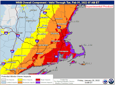
This is just one of many, many simulations of what might
happen later this week, but this illustrates the huge
area the potential winter storm covers. Here, it shows
show extending fro New Mexico through northern New
England and into Canada. Ice goes fro central Texas
to at least Ohio. Heavy rain is south of that.
A large chunk of the United States - most of the real estate east of the Rockies in fact, is in for a week of stormy weather.  

Different places will enjoy different types of icky or even dangerous weather at different times this week as the storm progresses. This will cover a really big area for a single winter storm. 

But, beginning today, we'll see a progression of snow, rain, ice and even fires as we go through the week.

Vermont's turn comes late Wednesday into Friday, but the only certainty in the forecast for the Green Mountain State is there won't be any wildfires or forest fires. More on Vermont's fate in a bit.

First, let's look at what's going on elsewhere and set things up.

The weirdest part of all this today takes place in Nebraska and South Dakota.  Ahead of a cold front that will play a critical role in this storm, warm dry winds will blow over the two states. They've had an odd lack of snow cover out there, so it's actually quite dry.

Despite it being the dead of winter in the northern and central Plains the dry, warm winds have that region in a high rangeland fire risk today.  I've seen this sort of thing in the southern Plains in the winter, but not this far north. Very, very strange.

By tomorrow, the cold front will extend roughly from Michigan to Texas. By then, the front will start to pick up a lot of moisture from the Gulf of Mexico as Arctic air plunges south into Texas.

The increasing moisture will go up and over the cold air, squeezing out a bunch of snow and ice. Winter storm watches already extend from Colorado and Kansas into Michigan.

The cold front will slowly move eastward, then kind of temporarily stall along the Appalachian Mountains by Thursday. Waves of low pressure will move northeastward along the front as it ever so slowly presses toward the southeast later Thursday and Friday.

This will ensure a long band of heavy snow and ice and rain from the Gulf Coast all the way up through New England and into southeastern Canada.  Large swaths of the nation will see rather heavy snow and areas of freezing rain also slowly press east. 

Out ahead of the front, warmer air and rain could create pockets of flooding in the Tennessee Valley.  And if the front stays hung up in northern or central New England, parts of the region closer to the coast that had the blizzard Saturday could be dealing with some flooding, too.

VERMONT IMPACT UPDATE

What happens to us with this system is still depending upon where the cold front slows down or stalls. 

If current projections are wrong on the position of the front by as little as 50 miles, what I'm about to outline goes out the window. It would be wrong. So stay tuned for changes.

Vermont will squeeze out one thawing afternoon Wednesday ahead of the cold front. A thaw has been a precious rarity through January, so this will be a switch. Don't get used to it though. It won't last.

The front is now expected to stall in central New England which would set most of Vermont up for snow Thursday and Thursday night, with a greater chance of a mix or rain in the southern half of the state.

Since there's so much moisture to work with, whatever falls could be on the heavy side. That means parts of Vermont could get a lot of snow. We're just not sure which parts yet. 

The snow or rain will start in lightly Wednesday night and early Thursday before changing to snow during the day from north to south and becoming heavier. At this point it looks like it would be a wet, sticky snow, then turn powdery later on in the event. 

This would be an ugly scenario on the roads. The wet pavement would freeze, then wet snow will compact into a thick layer of ice and freeze even harder as temperatures drop. Then snow would pile up on top of all that. A real mess.

So this storm bears watching.  

I almost guarantee the storm won't play out exactly as I described above. It could be colder, and there could be less snow if the front positions itself further south.  Or there could be more rain or freezing rain if things set up a little further north than people are expecting now.

For what it's worth, the American computer model, which has been more accurate than the European model, has pushed some hints that northern Vermont might largely miss out on precipitation again.  That's just one model run, though, so definitely don't hang your hat on that. 

The bottom line is to expect a mess Thursday and Friday, but I can't detail yet what kind of mess it will be. 


Sunday, January 30, 2022

Blizzard Over, But Much Of Nation, Including Vermont, Faces New Wide-Ranging Winter Storm

Some damage to trees from freezing rain in Alburgh,
Vermont in January, 2020.  The Green Mountain State
is at risk for a winter storm toward Thursday that could
drop a bunch of snow, rain, ice or all of the above. 
The remarkable well-forecasted Blizzard of '22 has wrapped up in New England, and we're just left with another frigid, below zero morning. 

The snow of course missed Vermont, but the icy air sure didn't. This was the 15th morning that Burlington, Vermont has gotten to zero or below this month. 

 That's the most in a single month since 17 such days happened in February, 2015. The most zero or subzero days in one month was 23 in January, 1970, says the National Weather Service in South Burlington.

Coming up, we have a warmup and a potentially messy, snarly possibility of a winter storm. More on that in a bit. 

First some final blizzard stats: 

The most snow I've seen reported from the storm so far is 30.9 inches in Stoughton, Massachusetts, followed closely by 30.4 in Sharon, Mass. and 30 inches in Quincy.  Many reports of more than two feet of snow came in from Massachusetts, especially in the South Shore area.

Boston picked up 23.8 inches of snow, their seventh largest snowstorm on record. It was also Boston's snowiest single January day on record as well.

The storm did verify as an official blizzard in parts of Delaware, New Jersey, Long Island, New York, eastern Connecticut, Rhode Island, Massachusetts, New Hampshire and Massachusetts. 

The last of the blizzard warnings in the United States expired in Downeast Maine earlier this morning.  As of 6 a.m., it has already stopped snowing in that neck of the woods.  The most reported snow in Maine was 18 inches at Brunswick. 

Some wags called this New England storm a "blizzicane" considering the several hours of sometimes hurricane force gusts along the coast. Barnstable, Massachusetts reported a gust to 83 mph and there quite a few gusts of 70 mph or more along the New England coast. 

Now that the Blizzard of '22 is over in New England, attention is turning to a new winter storm. 

NEW STORM

The National Weather Service is already gearing up to warn people of yet another nasty winter storm that will affect a broad area from Texas to New England during the middle of the week. This one will cover much more real estate than our dearly departed Blizzard of '22 did.

Worse, it will contain a wide variety of weather, including heavy snow, a bunch of freezing rain, possible flooding, a chance at severe thunderstorms, high winds and bitter cold, depending upon where you are. 

This won't be a powerful, deep concentrated storm like the one New England just had.  Instead, the next winter storm will be the child of a strong, warm ridge of high pressure off the East Coast, a feed of rich moisture from the Gulf of Mexico, and a sharp Arctic blast heading southward through the middle of the nation. 

By Wednesday, a slow moving cold front will extend from somewhere in or near northern New England to Texas. One or more storms will ride northeastward along this front, making full use of the deep Gulf of Mexico moisture. 

This far out, the devil is in the details as to who gets what and how bad. But this is a classic setup for a damaging ice storm somewhere.  At this point, that seems most likely in a band from northeast Texas, through Arkansas to southern Illinois, but that picture could shift north or south. 

Northwest of that ice would be a heavy snowstorm. People southeast of the ice zone could see some flooding. 

Also, as the storm eventually works its way into the Northeast, rain and thawing atop all that blizzard snow could also result in a flood.

Meanwhile, Texas can expect an Arctic cold snap that might not be as destructive as the disaster last February, but will still be a hard test for the state's rickety electrical infrastructure.

VERMONT IMPACTS

It's unclear what this new storm will do to the Green Mountain State, but it will probably be a lot more than the blizzard that missed us Saturday.

Depending on where the stalled front sets up, we could see anything from a heavy snowstorm, to another round of ugly freezing rain, or just warm, plain rain that could cause localized flooding especially if the rain breaks up ice in the rivers.

From this vantage point, the best chance of a snowstorm is north of Route 2 and the best chance of a warm rain is south of Route 4 on Thursday. Some places in Vermont could get a bunch of freezing rain, which isn't good. 

That's just a wild stab in the dark at this point. Vermont is going to be very close to some super warm air just to the south and some Arctic air just to the north. With that set up, it's impossible to tell at this point where in Vermont the cold air might invade, or where the warmth might filter in. 

We'll just have to update as we go along. Expect benign weather with a welcome warming trend through Wednesday. Then, all bets are off. 

Saturday, January 29, 2022

Evening Blizzard Update: Two Feet Plus In New England, Will Wind Down Tonight, Vermont Spared As Expected

Government Center Station in Boston today. Photo by
Scott Elsen/Getty Images.
As of late this afternoon, the big blizzard in New England was just a few hours away from winding down in Massachusetts and Rhode Island but was still going full tilt in coastal New Hampshire and Maine. 

Vermont was, as expected, a bystander to all this, but at least in northwestern Vermont, we got a very nice sunset out of the deal.  Sunshine in clear air over New York lit up the high clouds overhead in the Champlain Valley.

Of course, it's anything but nice further east. The highest snow total so far in Massachusetts is 24 inches in Bridgewater. There are several other reports of over 20 inches. Since it was still snowing at this report, those totals will go up. 

Highest official wind gusts so far were 81 mph in West Dennis and 78 mph Chatham, both on Cape Cod.

Snow amounts in New Hampshire and Maine were much less, mostly because the storm started later and there's been little time for accumulation. Those two states will end up with somewhat less snow than Massachusetts anyway. 

Islip, Long Island reported 22 inches of snow. New York City never did get into the heaviest snow bands, so Central Park came in with a respectable but not overwhelming 7.5 inches of new snow. 

At least in my opinion, the morning coastal flooding in Massachusetts was a little worse than expected. I do see some damage in some of the videos floating around on social media.

On the bright side, the worst of the storm surge hit during low tide later in the day, sparing the coast of any extreme damage.

People might laugh if anybody says climate change caused this storm.  The reality is global warming didn't actually cause this huge nor'easter but it probably made it worse than it otherwise would have been.

Water temperatures in theAtlantic Ocean along the path of the storm are at near record highs. The warmer the water, the stronger the storm and the more moisture can feed into the storm. When that extra moisture collided with the cold air over New England, you got the kind of dumping snow we saw today. 

One thing I haven't mentioned and should is that this storm is directing some awfully cold air into Florida. At least cold for them.

Freeze warnings extend as far south as places in inland Florida, due west from Miami.  Miami itself might go below 40 degrees for the first time in a decade. 

Hard freeze warnings are up in northern and central Florida, alerting residents o to overnight and early morning temperatures as low as 21 degrees.

It'll be so cold in Florida that it will rain iguanas tonight. These animals like to sleep up in the trees at night, but they lose their ability to function and grip things when it gets under 45 degrees. So they fall from the trees.

Unless something attacks them while they're on the ground, they'll be fine. They recover when it warms up again. The forecast high in Miami tomorrow is 64 degrees.

VERMONT IMPACTS AND WHAT'S NEXT

No snow from the blizzard in northwestern Vermont, but the 
shield of high clouds from the offshore storm did manage
to give us a decent sunset up in St. Albans. 
Far southern and eastern Vermont managed to get a tiny bit of snow out of this. Stamford and Readsboro, Vermont each reported 1.7 inches.  Putney managed 3.2 inches. Brattleboro had two inches by noon, so they probably ended up with three inches. No biggie.

It'll be another frigid night in Vermont, with temperatures below zero once again. 

However, we're getting a brief break from the repeated blasts of Arctic air that have been coming at us one after another this month. The first half of the week will bring us a moderating trend. Tomorrow will get into the teens, Monday the 20s, Tuesday the 30s and Wednesday possibly the low 40s.

The price we'll pay for this is a potentially very messy storm on Thursday. If we indeed get that late week storm, nobody knows yet if it will be rain, an icy mix, snow or all of the above. Stay tuned! 

VIDEOS:

With many of these, I don't want to run afoul and deny some of these video journalists their credit, so click on the hyperlinks in each description:

Coastal flooding and wild wind rake Sandwich, Massachusetts.

Obligatory video of giant waves crashing into houses in Scituate, Massachusetts. These Scituate videos surface after every big nor'easter but this one looks more damaging than most storms in recent years. 

Earlier today, things weren't  much better with the snow in Seaside Heights, New Jersey

Here's what it was like driving around Providence and Warwick, Rhode Island. 

In Boston, cars are hopelessly snowed in

Blizzard Continues To Blast New England But Avoids Vermont- Early Afternoon Update

Blizzard conditions in Niantic,
Connecticut this morning. Photo
from Twitter
@New_EnglandWx1
As of early afternoon our New England blizzard is behaving as forecast, so kudos to all the meteorologists who have been keeping us up on this one. 

Gusts over hurricane force in some coastal locations, near zero visibility, bitter temperatures and such are all slamming eastern New England.

The storm has left a trail of broken power lines because of the wind. At last report, 100,000 people were without power in the Northeast. 

It is kind of a weird looking nor'easter, with one main center southeast of Cape Cod late this morning and a subsidiary storm trailing it off the Mid-Atlantic coast 

The storm might not look pretty from space but it sure is doing its job down here on the ground. 

 There was an unofficial report of a 98 mph atop a bluff in Truro.  So far, the highest official wind gust I've seen is 78 mph.  

As of 11 a.m., the most snow reported in New England was a foot in Attleborough, Massachusetts, but those totals will rise tremendously before all is said and done. 

One especially heavy band of snow has been parked along the Massachusetts South Shore for hours. That's where the highest snow totals will be reported - possibly near three feet.  It's also where meteorologists have said for a couple days said would be Ground Zero for heaviest snow.  That's an incredible forecasting feat to get that right a couple days in advance. 

In New Jersey, the snow was gradually diminishing as of noon, but there were plenty of reports of 15 or 16 inches of snow on the Jersey Shore. That area, along with parts of Long Island and Connecticut, officially had a blizzard, which is defined as at least three consecutive hours of 35 mph or greater winds combined with lots of falling and/or blowing snow. 

I'm sure Massachusetts will also soon go into the confirmed blizzard zone.

VERMONT UPDATE

There's certainly no blizzard in Vermont.

Satellite view of the big nor'easter. Click on the image
to make it bigger and easier to see. Note the bumpy
nature of the clouds near the coast, indicating heavy 
precipitation. Also note the clear skies just to the west
of Vermont in northern New York. The dry air is winning
out so far, preventing snow from getting much into Vermont.
The frigid, dry air from Quebec was winning out in Vermont as of noon. The light snow in southern and eastern Vermont was not advancing northwestward, at least so far, and where it was falling, it was light.

Up here in northwestern Vermont, the dry air victory is obvious. The overcast in St. Albans has thinned a bit. Clear blue skies are visible far off to the west. 

The cold air drainage from Quebec plus the overcast skies have kept temperatures from rising. Burlington reached 3 below at 5 a.m. and was still at that level at 9 a.m, and had only risen to 1 above at noon. .......

Winds, as expected, had increased, and probably will get even stronger as the afternoon goes on, so wind chills will continue to be miserable - in the teens and 20s below zero in most spots. 

Blizzard Slamming The Northeast In (So Far) Amazingly Well Forecast Historic Storm

Screen shot of the blizzard in Plymouth, Massachusetts
this morning. This is a screen shot of a video from
@mikeseidel via Twitter. 
Blizzard day is here for much of New England and other parts of the Northeast. Just as advertised, this is turning out to be a historic humdinger. 

Torrential snow and increasing wind were already socking Delaware, coastal New Jersey and Long Island as of 6:30 a.m. and those conditions were mowing their way into eastern New England.

Forecasts continue to call for record snowfalls in some areas and dangerous blizzard conditions.  Nobody should be out driving in the blizzard zone today, which extends from Delaware to Maine. 

Even with the storm underway, there's always going to be slight adjustments in the predictions for this storm. We call those last minute adjustments "nowcasts"  instead of forecasts.

Overnight guidance and observations have nudged the snow area ever so slightly west, and perhaps intensified the already ridiculous expected snowfall rates in eastern New England. 

Since we here in Vermont aren't getting the worst of this, I'll offer the Green Mountain State rundown on this storm further down in this post.  There have been a few minor potential adjustments to the storm forecast here in Vermont.

THE STORM ITSELF

As a weather geek, it's been fascinating to watch this storm explode from a disorganized patch of showers in the Atlantic Ocean southeast of North Carolina to a blossoming mega-storm. 

The storm is an obvious bomb, meaning its still strengthening at a rapid rate. It's still forecast to pass near the "bench mark" southeast of New England at 40 degrees north, 70 degrees west, by later this morning and northward into the Gulf of Maine this afternoon and evening. 

Pretty much always with a powerful nor'easter an especially heavy band of snow sets well west and northwest of the storm center and this storm is no exception.

Meteorologists anticipated this and made forecasts with huge accumulations accordingly. So far, the heaviest snow has set up right where they were anticipated.

WHAT'S HAPPENING

This is a fast-developing situation, of course, in a heavily populated area of the nation, so the reports will come in fast and furiously today.  I'll update as warranted through the day.

In the predawn hours, an especially heavy band of snow set up right along the New Jersey coast.  Winds were increasing, too, and, as the National Weather Service in Mount Holly, New Jersey noted, whiteout conditions were occurring and travel was impossible.

By 6:30 a.m., some areas of New Jersey near the coast were already closing in on a foot of new snow. The New Jersey coast snow band was expected to last into midday, so I wouldn't be surprised if reports of two feet of snow came in from there.  

Satellite view of the storm developing overnight. 

Going north if anything it gets worse. 

Those harsh and dangerous conditions spread rapidly north and enveloped Long Island before dawn and were reaching into eastern New England.  As the offshore nor'easter continues to mature, this band of snow was expanding and intensifying, in an early morning statement. 

I won't be that surprised if some spots have accumulation rates as high as five inches per hour on Long Island and eastern New England. 

Since the nor'easter is strengthening, so is the wind.  Before dawn, gusts as high as 66 mph in Delaware.   That will only get worse and quickly spread northward later this morning.   Later, higher wind reports started coming in up in New England: Gusts of 69 mph in Nantucket, 68 mph in Dennis, Massachusetts and 66 mph in Fall River, Massachusetts.

Wind gusts will probably go higher than that by the time we're done here. 


As of 6:30 a.m. the real heavy, blinding snow and wind were just getting into southeastern Massachusetts and Rhode Island.  Boston was still reporting just light snow but by the time you read this, that would have changed. 

Travel will soon be impossible in this area, if it isn't already.  Massachusetts officials were wise enough to ban tractor trailers from the roads in much of the state to help prevent the kind of trapped vehicle nightmare that hit Virginia at the beginning of the month. 

Travel bans are also in effect in surrounding states. Amtrak has suspended service in much of the region.  And I'll laugh my ass off if you even try to get a flight out of Logan in Boston today. 

New Hampshire and Maine will probably wait until this afternoon to see the brunt of this storm.  Things might be OK in Portland and Bangor now, but watch out.  It's you're turn once we get past noon

VERMONT IMPACTS

We're still not going to see huge effects from this storm. However, there's an interesting squeeze play happening.

On one hand, it seems like at least light snow might want to go a wee bit further west than earlier thought. Light snow had reached Rutland before dawn, for instance. On the other hand, the air feeding down from Quebec is super dry, so that air could easily squelch and evaporate any snow that wants to head west of the Green Mountains. 

Which will win?

For now, it's a steady state forecast for the day, with up to five inches of wind blown snow expected in the extreme southeast and northeast corners of Vermont.  The Connecticut Valley is still forecast to receive one to three inches.

At this point, I'm betting on the dry air winning out. The snow in Rutland later stopped as drier air kept filtering in.  That's a sign right there that it will be difficult to get snow, especially the more you get away from the Connecticut River.

Don't be fooled by today's radar images.  The radar will show snow extending across Vermont into eastern New York. A lot of that will be snow falling from clouds but evaporating on the way down due to that feed of dry air to the north. 

It isn't that windy in Vermont yet, because the storm is still so far south of us. But there's more squeeze play to talk about. Once the storm gets near New England, the pressure gradient between that deep, deep low pressure nor'easter and Arctic high pressure to the north will increase the winds. 

North/south oriented valleys especially will see gusts to 40 mph this afternoon. That with continued cold temperatures will make today raw and cold with low wind chills.

For those Vermonters who are bummed this storm is missing us, there's a glimmer of hope down the road.

Although there may actually be some thawing temperatures later in the week, a moisture-soaked system seems to be on its way around Thursday. It might just be cold enough in northern Vermont to squeeze out a bunch of snow.

That's not a done deal by any means, but it's something to watch.

Friday, January 28, 2022

Friday Evening Update: No Big Changes, Dangerous Day Saturday In Eastern New England

The general idea on accumulations with this huge nor'easter.
The further east you go in New England the worse it will
get. Click on the map to make it bigger and easier to see.
Dark blue is four to six inches, rising to more than two
feet near and southeast of Boston. 
Through the day today, I haven't seen many changes in the thinking for this huge nor'easter that will hit parts of the East Coast, especially New England late tonight and tomorrow.  

Many of the little forecast changes I did see confirm what was already predicted.  

As expected, the area covered by blizzard warnings has been expanded. In Massachusetts, where the blizzard warning this morning was just along the coast.  Now, it extends inland to I-495 almost all the way west to Worcester, and all of Rhode Island.

Also included in the blizzard warning to southeastern Connecticut, the eastern two thirds of Long Island and parts of Delaware. 

The blizzard warning was also extended inland in Maine, including Bangor. 

In Vermont, the National Weather Service has settled on a winter weather advisory for the far southeast  and northeast corners of state, with an expected accumulation of three to six inches in both places.  Wind gusts of 40 mph will blow that snow around. 

The rest of Vermont east of the Green Mountains could receive a badly windblown one to three inches of snow. Western Vermont, especially north of Rutland, can expect very little if anything.  These figures could increase if the storm jogs further west, but so far, that's looking doubtful.

Interestingly, this snowfall scenario is what the American computer models were forecasting three days ago. Since them, all the models have flip flopped on how this will play out, but it's cool the American model had a good sense of things three days out with a very complicated system. 

North winds gusting to 40 mph or so will make Saturday raw and miserable as actual temperatures stay in the single numbers. 

Just as forecast, the storm started forming today off the northeast coast of Florida. It was amazing to see that the disorganized clump of light showers late this morning   off of the coast between Florida and North Carolina will turn into this monster storm, but there you go. 

This thing will develop explosively as it heads north tonight. 

Winter storm impact level is purple along the immediate
New England coast, which is regarded as "extreme"
Large area of red is "major" impacts

I want to take a side excursion here and highlight something that really ticks me off. I've already brought up workplace safety issues in severe weather in previous posts. 

I'm noticing, like in many dangerous blizzards that some employers are insisting workers show up in the midst of what will be a dangerous, life threatening storm in parts of New England.

Mostly these workers are in retail and fast food and that type of thing. Nobody in their right mind will shop or go out for a Big Mac in Boston or Providence or places like that tomorrow. Business will suck at these stores.

But, store owners and franchises can't lose the opportunity to make just a couple bucks. So what if the employees that they order to come in get hurt or even killed out on impassable roads right? They're regarded as replaceable cattle, so no great loss.

That attitude toward low wage workers in the U.S. is an abomination.  But I guess I'm in the minority there. 

OK, off the soapbox and back into the weather. 

Needless to say, travel will be pretty much impossible in the areas under the blizzard warnings and in many areas under winter storm warnings.  Snow in some places will accumulate at a rate of three or more inches per hour. The National Weather Service office in Boston says it's conceivable that snow accumulates in a few spots at a rate of five inches per hour, which is really off the charts. 

That makes it impossible for road crews to keep up, especially since the strong winds will pile the snow into gigantic drifts. 

Total accumulations of 1 to 3 feet will be common in eastern New England.  I can easily see a few places getting three or more feet of snow with this. 

Everyone in the blizzard area needs to stay at home during this. Totally safe there. 

So far, at least 2,000 flights are canceled, including 85 percent of flights out of Boston's Logan Airport.  By tomorrow, I'm guessing all Logan flights will be wiped out. 

Back here in Vermont, we won't necessarily be out of the woods with winter storms, even as this giant nor'easter just barely glances us.  Signs are beginning to point toward some sort of messy storm in the second half of next week for our area.

Will Lake Champlain Freeze Over This Winter?

Screen grab from the WCAX Sky Watch 3 ECHO Cam on
Burlington, Vermont's lakefront Thursday, January 27
still showed plenty of open water, even inside
the breakwater, despite several bouts of subzero cold. 
It's been a cold month, with lots of relatively calm and frigid, subzero nights. 

That's perfect for forming ice on lakes.  Pretty much everything is frozen over in Vermont now, except for parts of Lake Champlain.  

That's pretty normal, since it takes a long time for a large and deep lake like this one to completely freeze. 

Much of Lake Champlain has frozen, but as of today, January 31, large areas in the middle of the lake are still open.   The WCAX Sky Watch 3 ECHO Cam at the Burlington waterfront showed that area to be largely ice free.  

Much of the area inside the breakwater was still open, which surprises me considering how cold it's been lately. The area inside the breakwater tends to freeze quite a bit sooner than the open lake beyond. Burlington was at or below zero on 15 days this January.  That's the most in one month since February, 2015. The lake did freeze over that year, starting on February 16

 Maybe an unusually warm December that notably lacked cold nights is a lingering reason for that remaining open water this year. 

Lake Champlain still has a relatively decent shot at freezing over this winter.  A brief thaw seems likely this Wednesday, but temperatures will fall well below freezing again by Friday. Long range forecasts, though somewhat unreliable, don't seem to indicate any huge warmups through mid-February. 

We still have plenty of winter left in which the lake can freeze over. Since 1960, when the lake has frozen over, it's happened anytime between January 14 and March 8.  The freeze over, when it happens, is usually around the middle of February. 

Although climate change makes it less likely, February can be brutally cold and plenty frigid enough to completely freeze the lake. Just ask the Februaries of 1934, 1978, 1979 and 2015. 

If the end of February and early March is particularly cold and calm, a freeze over can happen then, obviously. But after Valentine's Day, things start to work against a Lake Champlain freeze over.  Average temperatures begin to rise as we head toward spring, so frigid Arctic air begins to get a little less likely.

The sun angle is increasing nicely by mid-February too.  The dark open water next to the ice, or dirt particles on the ice become better at collecting the sun's warmth, aiding in daytime melting.  Nights are a little shorter, too, by late winter, so an overnight period of calm, subzero temperatures doesn't last as long as it did in January. 

Lake Champlain freezes over less frequently than it once did,  thanks to climate change. The last time it completely froze was as of March 8, 2019.  That was the last time we had any sustained winter cold spells, until this month. In the past decade,  the lake has only frozen over three times.

If you had to pick a time when Lake Champlain freeze ups really start to get less common, it seems to be in the 1990s. 

 You have to go back to the 1970s to see the lake frozen most years.   Going even further back before the age of airplanes, Lake Champlain was regarded as totally iced over virtually every year. However, in those days, the lake was eyeballed from the shore, and areas of open water were almost surely overlooked in some winters. 

By the way, if Lake Champlain does entirely freeze over this winter, don't be like some foolhardy people I've seen in the past and try to walk, say, from Burlington to Plattsburgh.  The middle of the lake in particular is pretty unsafe even when frozen. Plus, it's extremely easy to get disoriented and lost out there if it starts to snow or wind creates a ground blizzard.

If Lake Champlain completely freeze this winter. Enjoy it.  Chances are with our new, warmer climate, it could be a few years before you see it again. 


Historic Northeast Blizzard Set To Strike; Some Vermont Forecast Adjustments

Predicted accumulations of snow with this nor'easter.
Since this map was made, projections have 
been bumped westward a bit, so the strip from 
eastern Pennsylvania through eastern Vermont
could easily get a bit more than projected here.
Click on map to make it bigger and
easier to read. 
 Well, this will be an impressive storm. 

Maybe not for everybody here in Vermont, but for large swaths of the Northeast, where a full-blown blizzard is likely in some areas from New Jersey to Maine. 

Up here in Vermont, we're definitely not in the crosshairs of this storm. However, there's been a few forecast adjustments, especially for southeastern Vermont. I'll get into that further down in this post. 

Depending upon where the heaviest snow bands set up, a few cities in eastern New England could see their largest snowstorm on record.  

We're already seeing some comparisons to the famed Blizzard of '78, though coastal storm surge destruction will be much, much less than that extreme New England disaster in 1978

However much snow Boston and other areas receive out of this, the snow will be tough to measure. Rare blizzard warnings are now posted for coastal New Jersey and along the east coasts of Massachusetts, New Hampshire and southern Maine. 

I'm pretty sure blizzard warnings will be expanded to some other areas of the Northeast as well. 

In Boston, this is the first blizzard warning since March, 2018. Winds along the New England coast could gust to 75 mph. 

This will be a cold storm for areas under blizzard and winter storm warnings. Frigid air from places like, well, here in Vermont will get sucked into the storm, dropping temperatures into the teens and low 20s during the height of the storm. 

This will create an especially powdery snow which will blow around easily.  Anyone in the blizzard and winter storm warning zone should just hunker down at home Saturday and not venture out.  The zero visibility, snowfall rates in some areas of three to four inches per hour and the howling winds will almost certainly get you trapped in frigid conditions if you're out walking or in your car. 

It'll be interesting to see where the heaviest snow will set up.  There's almost always an especially heavy band of snow to the northwest of a nor'easter's center, and this will be no exception.  Somewhere in eastern New England, there could be a narrow band of up to three feet of snow, with as little as a foot in lull areas either side of that band.

The storm certainly has enough dynamics and moisture to work with. It'll get some added energy from warmer than normal water temperatures off the New England coast. The National Weather Service in Boston is describing this as a "fire hose" of moisture off the Atlantic.  

Fingers crossed, but the storm surge flooding might not be all that extreme. The worst of the storm surge in New England is expected to come Saturday afternoon, near low tide.  That will minimize destruction, but there still will be erosion, some flooding and battering waves.

Luckily, the storm will be moving right along, so it will be over for New England, except perhaps northeastern Maine, by Sunday. 

VERMONT IMPACTS

The forecast track of the storm seems to be drifting a little further west with each forecast cycle, so we'll see a little more oomph than original thought, especially in the southeastern corner of Vermont. It still looks like little or no snow in the northwestern part of the state, unless there's a big surprise. 

Whatever happens,  Saturday is NOT going to be a nice day anywhere in Vermont, even as we avoid the worst of the storm.  

Winter storm severity index. Click on map to make it
 bigger and easier to see.  Areas in red depict
major, damaging impacts. Subtle purple areas in
map are small areas of extreme expecred impacts

The latest in a long series of Arctic cold fronts is moving through Vermont this morning.  A few snow showers are drifting down, but they won't amount to too much. I can see a few places getting an inch or even two this morning, but most areas should see a half inch or less.

 As of 8:15 a.m. it's snowing lightly but at a decent clip, and we have a half inch new here in St. Albans, Vermont. 

Of course the latest brief blip of mild-ish air will quickly flush out today. Temperatures in the 20s today will crash into the single numbers this afternoon and back below zero for most of us tonight. The winds will continue. 

Then the storm will approach.  Forecasters have expanded a winter storm watch - not a warning, at least not yet - in New Hampshire all the way to the Connecticut River, and in Windham County, Vermont. This is  down around Brattleboro, Newfane, that neck of the woods.

If the more westward track holds, these areas along the Connecticut river and in far southeastern Vermont could easily receive a half foot of badly windblown snow.  It's still a bit of a question mark, but the chances of that type of impact there seem to be rising.

Depending upon the track and intensity of the nor'easter, some light snow might battle its way as far west as Rutland County, and along the spine of the Green Mountains all the way to Route 2, or perhaps even the Canadian border. 

Since the storm will be heading due north, the cut off of snow versus no snow in Vermont could largely be north-south instead of on a southwest to northeast orientation as per usual.  If the north-south orientation takes shape, parts of the Northeast Kingdom could squeeze out a few inches of snow fro this. 

In any event, the storm's attempt at light snow in Vermont will be battling very dry air draining south from Quebec so that bit of snow might not win the battle. The bottom line is, unless there's more surprises, like a firmer westward jog in the storm track, snow outside the southeast corner of Vermont does look lame at best.

We'll still be in the wind envelope of the storm, though, so north winds will gust to 40 mph in some areas as temperatures stay in the single numbers under an overcast sky. A nasty day indeed.

Looking further ahead, that promised thaw later in the week now has an iffy character at least in northern Vermont.  Conditions Thursday and Friday in the Green Mountain State could get "interesting" and troublesome late next week, but let's just set that aside for now and get through this nor'easter.


Thursday, January 27, 2022

Thursday Evening Update: New England Braces For A Wallop

The National Weather Service office in Boston is conservatively
forecasting up to two feet of snow, propelled by winds of
 up to 65 mph in eastern Massachusetts. It's actually
quite possible that this area could get three feet of snow.
I usually don't do twice or more daily updates on a weather event that is only expected to graze Vermont, but the upcoming storm is so big that it warrants attention.  Especially since it is hitting pretty close by, in parts of New England south and east of Vermont. 

This isn't to say Vermont will have no effects from this storm. There still might actually be a plowable snow, perhaps four inches in the far southeast corner of the state if things tilt our way some. 

Plus, the gusty north winds and frigid temperatures here on the western periphery of the storm won't exactly make us Vermonters comfortable

The developing storm still had a lot of moving parts as of late this afternoon, so it wouldn't surprise me if some last minute changes to forecasts pop up.  But during the day, the prognosis for this storm has remained relatively unchanged since this morning. 

Weather alerts are expanding, though as we get closer to the storm and its impacts gradually become more clear. By late afternoon, winters storm watches extended along the immediate East Coast from northeastern North Carolina to the eastern half of Maine. 

The watch was upgraded to a winter storm warning for coastal Delaware and New Jersey.

Many areas from eastern Delaware, coastal New Jersey, Long Island, and the eastern third of New England could easily experience full-on blizzard conditions during this.  It's likely to be a particularly windy storm, with many areas experiencing gusts to 65 mph.  

Many coastal areas are bracing for destructive storm surges and battering waves. Video from Live Storms Media showed equipment trying to shore up sand dunes in front of beach homes in Sandwich Massachusetts, for instance. 

Storm chasers are positioning themselves along coastal areas, too.

Some of the storm's ingredients were already spreading snow through places like Colorado, northern Texas and parts of Oklahoma. 

To oversimplify, energy is still forecast to start consolidating off the northeast coast of Florida during the day Friday.  The storm will strengthen explosively while heading northward,  east of the Mid-Atlantic states during the day Saturday and past New England late Saturday afternoon through the night. 

A band of extremely heavy snow will form west of the storm center, though nobody is 100 percent sure where that might be.  Best guess is in southeastern Massachusetts, Rhode Island and eastern Long Island. Wherever it sets up, snowfall rates of more than three inches per hour, combined with those strong winds will create whiteouts. It will be extremely dangerous in these areas to be outside or driving in those conditions. 

Parts of southeast New England could easily receive a quick two feet of snow out of this, with three feet definitely not out of the question.  Imagine the snowdrifts, too, with that much snow and that much wind. 

Back here in Vermont, the best chances of anybody seeing snow is down by Brattleboro.  It's hard to say how much they'll get, but unless there's a huge surprise, expect less than six inches down there. The rest of eastern Vermont could receive a dusting. Northwestern Vermont still looks to receive nothing. 

Saturday still won't be a day you'll want to be outside. Actual temperatures will not rise much beyond 5 above. North winds will drive wind chills into the 20s below zero. Overcast skies mean there won't be any sun to brighten things up or add any modest warming. 

The good news is the cold snap Friday into early Sunday is going to be the last one for a little while. Unlike the pattern we've seen much of this month, there won't be another Arctic cold front lurking to come through to squelch any early week warming trends.

In fact, it's still looking like we're in for a thaw Wednesday and Thursday. 

Nominee For World's Most Moronic Snow Plow Operator

Video still showing a clueless snow plow driver in Ohio 
blithely spraying chunks of ice and slush into 
the opposite lane of the Ohio Turnpike, damaging 50
cars and injuring 12 people. 
 I live on what is officially a Vermont State Highway, (Route 36) so trucks from the Vermont Agency of Transportation plow snow and spread salt on the road that runs in front of my house. 

I'm always impressed by how professionally and promptly clear the roads at all hours of the day. 

I'm also pretty sure highway crews in other states are just as good at their jobs.

But there's bad apples everywhere. Which takes us to the Ohio Turnpike in Erie County, Ohio. There, a clueless plow truck driver and moron decided to cause some havoc.

The stuff he was clearing from the westbound lanes of the Ohio Turnpike consisted of heavy slush and chunks of ice.  The driver could have arranged the plow to push the slush off the right side of the highway, or at least go slow enough so the ice wouldn't go all over the place if he wanted to clear it in the opposite direction.

Instead, the oblivious idiot went fast enough to propel the slush and ice over a median barrier and onto traffic in the eastbound lanes of the Turnpike. For two whole miles at least.  

He did this without seeming to notice he was wrecking car after car and causing a number of accidents. By the time Moron Plow Driver was done, at least 50 cars were damaged and 12 people had injuries. Luckily, none of the injuries were life threatening.

Which is a miracle. Video of the incident showed numerous tractor trailers on the highway, which could have lost control during the incident and flattened smaller cars.

News video, which includes a video of the slush and ice being dumped on the highway and smashing into cars and causing crashes, is at the bottom of this post. 

Needless to say, the motorist affected are wicked pissed. People were stranded without cars.  Owners of damaged cars were told to file a police repot and the the Ohio Turnpike and Infrastructure Commission would deal with insurance claims.

But other than that, everybody was on their own. One woman from Youngstown with a damage car was just dumped at a local McDonald's and told to figure out on her own how to get home. 

The Commission put the Moron Plow Driver on administrative leave pending an investigation. They also did some drug and alcohol checks on the guy.

The Ohio Turnpike and Infrastructure Commission statement, included in this news report, is a triumph of vacuous PR damage control attempts, but it's so florid that whoever wrote it was really desperate.

They smell the lawsuits coming.

I don't mean to disparage that whole commission, as I'm sure most of them are cool and know what they're doing. But yikes!

By the way, the vast majority of crashes involving snow plows are not the fault of the snow plow drivers.  Seems like other motorists can't seem to avoid smashing into what we would think are highly visible, big trucks with flashing lights. But what to I know?   

Despite my high confidence in Vermont snow plow drivers, I'm going to be more than a bit careful when I see the plow's wave of snow coming my way. 

Here's the news video that includes the images of the plow spray that snow and slush. The video report says 40 cars were damaged but that was later updated to 50 or so.   Either click on this hyperlink, or view below:


Big Nor'Easter Almost Definitely A Miss For Vermont; Eastern New England Still Target

The thin snow cover, about five inches, on my property
in St. Albans on Tuesday. It's looking unlikely that
the expected big nor'easter on Saturday will add any
snow cover for the this part of Vermont. 
I'll get into the updates on the nor'easter in a sec, but I have to acknowledge another impressively cold morning in and around Vermont.  

Island Pond got down to at least 35 below early this morning, which at least ties for the chilliest reading of the winter in the Green Mountain State.  Most everyone else in Vermont was in the teens and 20s below this morning.

The way things are shaping up, this morning and last Saturday will pretty likely - but not definitely - be the coldest spells this entire winter. We have more cold weather coming up, but it doesn't look like it will be that frigid again for awhile.

Now, that nor'easter.  As usual with this type of storm,  the computer models have been "windshield wipering" with its path, sometimes taking the storm a little further offshore, others bringing it a little closer. 

At this point, things are consistently pointing to a nothing burger for Vermont, aside from gusty north winds, a nasty wind chill and maybe some light snow in southeastern Vermont on Saturday. 

There's still a slight chance we could get a surprise hit, as a small number of models blitz Vermont with snow. But as of this Thursday morning it's looking pretty doubtful we'll join in the "snow fun." 

That leaves us with the question as to how extensively this thing will battered eastern New England.  As the National Weather Service in Boston notes, a lot will depend on how a dip in the jet stream aligns itself in the Ohio and Tennessee valleys tomorrow. 

A sharper dip would bring the storm a little closer to the coast, less sharp, it would be a little more offshore.  In any event, this will be a rapidly strengthening and powerful storm as it passes by New England Saturday. 

Either way, it seems like a lock that at least some of eastern and perhaps central New England will get a lot of snow out of this.  High winds and coastal flooding are also going to be a problem. How bad those two issues will get will depend largely on how close to the coast the storm ultimately gets. 

We still have some questions as to how far west the heavy snow reaches on Long Island, and will it reach to near New York City and the Mid-Atlantic States.

For now winter storm watches hug the coast from Virginia, on up through New Jersey and the New York City area, and then roughly into the southeastern third of New England. 

By the way, after this goes by and another shot of frigid air arrives, it's beginning to look like we back here in Vermont could get our first real thaw since New Year's Eve.  Temperatures could reach the 40s Wednesday and Thursday.

A weather system accompanying this warmth appears to want to give us rain toward Thursday, so Vermont's snow drought will continue on. 

Wednesday, January 26, 2022

Will Olympic Athletes Choke On Foul Beijing Air? Some Officials Worry

Officials are worried about air pollution in and near 
Beijing during the upcoming Winter Olympics next month.
On top of everything else to worry about with the upcoming star-crossed Winter Olympics - Covid, China's government, etc there's another potential problem: nasty air pollution.  

As the Washington Post notes:

"With less than two weeks to go  until the Opening Ceremonies of the Beijing Winter Olympics, the Chinese government said is battling 'extremely unfavorable' weather to clear the city's skies of hazardous smog."  

Air quality in Beijing has a reputation of being lousy, especially in the winter, when temperature inversions trap pollutants over the city.

An inversion is a layer of relatively warm air over a layer of colder air at the surface. The inversion acrs as a lid, preventing pollutants from blowing away and dispersing. 

The Chinese government has been working for months, even years, to find ways to minimize the winter pollution in time for the Olympics.

Agence France-Presse reports:

"In an attempt to clear the smoggy skies, steel plants around the city were ordered to cut production in half in August and coal stoves in 25 million households across northern China were replaced with gas or electric burners ahead of the Games."

Fine particulates which can cause problems ranging from heart attacks to lung cancer to premature babies, was at 33 micrograms per cubic meter of air last year.. That's down by a third from 2013 but still about six times higher than levels recommended by the World Health Organization, notes Agence France-Presse. 

Fossil fuels are of course a huge source of the problem in China.  Almost 60 percent of China's economy is powered by coal.  China has also seen surges in fossil fuel imports and mining to combat power shortages that have dampened factory output and the overall economy.  

The immediate weather forecast is not terribly encouraging. Conditions favoring a temperature inversion are expected to intensify as we approach the end of the month. Chinese celebrate Lunar New Year's Eve on January 31 with fireworks, which would certainly worsen the pollution in Beijing. 

The Olympics are scheduled to run from February 4 to 20. 


Greece, Turkey, Other Mediterranien Areas Hit By Rare Heavy Snow

Cars stuck in one of the worst snowstorms in Greece in
decades this week. Photo by Thanassis Stavrakis/AP
As occasional very light snow dusted us here in Vermont this week and we await news on whether it'll be our turn to get nailed with a snowstorm this weekend, Greece and Turkey are buried in white.  

Some of the worst snowstorms in years, even decades focused their fury on those two nations this week. 

It snows a little in Athens pretty much every winter, but this was quite a bit bigger than usual. "The height of the snow is unprecedented in some areas, Christos Stylianides,the Greek Climate Change and Civil Protection Minister told the AP.  

Echoing that Interstate 95 disaster in Virginia earlier this month, thousands of motorists were trapped on highways in Greece during the height of the storm. The Greek Army was removing the cars from the highways as the storm waned.

In one strange moment in the Greek storm, a waterspout on the Mediterranean managed to make landfall, throwing snow into the air. 

Istanbul,  Turkey received 13.4 inches of snow, with thunder mixed in.  Like Athens, it snows at least a little most winters in Istanbul, but this was much heavier than they usually get. The city's airport closed, and the snow was heavy enough to cave in the roof of a cargo terminal.

Some higher elevations around Istanbul received more than 30 inches of snow. 

The snow extended to places where it almost never gets dumped on. Antalya, Turkey on the Mediterranean coast, had its first snowfall in 29 years. 

The same was true on some Greek Islands.    Local media said the snow was a "once in a lifetime weather event" on the Aegean Islands, including Syros, Naxos, Tinos, Mykonos and Santorini.  

A bit of an editorial here: I'm pretty stunned by the explosion lately of highly unreliable, doctored or fake YouTube videos of weather events lately. You really have to wade through lots crap posted by bots to find actual credible videos. That's sad of course.

I think I've found a few videos that reflect reality, though. As usual, if you don't see the video in this post, click on the hyperlink instead. 

Here is a nice walking tour of Athens during the pretty but also messy snowstorm: 


Here's a Reuters report of the snow in and around Istanbul, Turkey:


This one is the most dramatic. It shows the collapse of a cargo terminal under the weight of the snow at an airport in Istanbul, along with other scenes of chaos at that airport. 


As We Wait In The Cold, What Will That Big Weekend Nor'easter Do?

We know there's going to be a really big storm near
 New England Saturday, but there's still some
questions on how it's going to play out. 
Vermont might or might not get a bunch
of snow out of this. 
UPDATE 5 p.m. WEDNESDAY

Just a quick update to this morning's post, since all eyes are on that nor'easter that's planned for the weekend.

If you were praying for a big dump of snow from this in Vermont, hopes are fading. 

The European computer models, which had a more westward track, meaning a greater chance for a bunch of snow, is trending in the direction of the American models, which have been largely indicating a miss for the Green Mountain State.

The storm is still two or three days away, so it's still possible the computer models and meteorologists are not yet picking up on something that would drive the storm more toward the coast, but few if any people are seeing it. 

If the computer models out now are accurate, then Vermont could still get a wee bit of snow out of this, especially east of the Green Mountains.  Eastern New England at this point is still in the crosshairs for a huge, disruptive storm. 

Stay tuned for updates, with a  more comprehensive one tomorrow morning.

Meanwhile, bundle up for another frigid Vermont night. 

PREVIOUS DISCUSSION:

Yeah, yeah, I know it's cold out again today.

As has been the case with these cold waves, northern New York was again the prime target of this latest shot of Arctic air. 

It was in the 20s below in much of that area this morning, with Ogdensburg once again being one of the nippiest places at 24 below.

Vermont was "warmer" I suppose, with the lowest readings in the northwestern corner of the state, where it approached 10 below.  The rest of the north was in the single digits below zero, with some places still above zero in the far south.

Today will be another one of those bright and sunny and cold days we've seen so many of this month.  Highs should make it into the single numbers this afternoon.

Tonight is another ice box night everywhere, but especially east of the Green Mountains, where some more 20s below spots should appear. Most of the rest of us will once again visit the teens below zero.

'Thursday will be a little better with readings getting to near 20 ahead of the next cold front, which will arrive Friday to put us back below zero by Friday night. 

Then things get interesting

THE BIG NOR'EASTER

Well, somebody is going to really get rocked by this storm, but the devil is still in the details. Vermont is near the western fringe of the the "clobbered" zone.

Here are what we know so far.  As usual, forecasts are subject to change as new data comes in. 

The storm is forecast to start forming off the east coast of Florida Friday morning,  and move at a pretty good clip pretty much due north, so it will be southeast of Cape Code by around noon or so Saturday.

The nor'easter is expected to be a "bomb cyclone" meaning it will explosively strengthen in its trek northward to near New England.  By the time it reaches New England, the storm will be capable of producing blizzard conditions, winds gusting to as high as 70 mph near the coast and storm surges and coastal flooding.   

Whether Vermont gets a lot of snow from most nor'easter
depends on whether the storm goes west or east of the 40/70 
bench mark, which is the black dot on this map. West of
the benchmark increases the chances Vermont gets a 
good deal of snow. Image is from NYskiblog.com

Whether all that mayhem happens and which real estate might be targeted all depends on the exact track and to an extent the timing of the storm. 

Meteorologists look at something called the "benchmark" when forecasting the type and ferocity of nor'easters passing by New England.

The benchmark are the coordinates latitude 40 degrees north and longitude 70 degrees west, which is southeast of New England..

Generally speaking, if a nor'easter goes a little to the south and east of the benchmark, then southern and eastern New England get the heaviest snow and Vermont misses out.   If a nor'easter goes a little to the west and north of the benchmark, then the coast could get mixed precipitation and Vermont stands a better chance of getting some decent snows.

This benchmark thinking doesn't always work, but it's usually a good rule of thumb.

With this expected monster storm, the thinking is it will be somewhere near the benchmark when it comes by New England.  Most of the American computer models take it a little east of the benchmark.

That would mean eastern New England would get clobbered and Vermont would be more or less spared, especially northwestern areas.

The European model wants to take this storm a little west of the benchmark, which would put Vermont in play. Especially eastern Vermont. 

I'm not sure this means much, but so far this winter, the American model has been forecasting storms with more accuracy than the European model, so there's that.

The bottom line is, we're not exactly sure about Vermont yet. At this point, I'd say chances are pretty good that northwestern Vermont would get little or nothing out of this aside from frigid, strong north winds. Eastern Vermont might or might not get a decent snowstorm out of this.  I, along with actual meteorologists who are much smarter than I am, are on the fence with what'll happen east of the Green Mountains. 

It's only Wednesday, so there's time for the storm's expected track to become more clear.  

My advice: If you were planning a trip to anywhere in the eastern half of New England this Saturday, go ahead and cancel those plans right now. In Vermont, have the snow shovels ready, but there's no guarantee you'll actually use them this weekend. 


Tuesday, January 25, 2022

Snow Showers Slowly Flutter Down, And I Experiment With Slowing Them Down

 Fluffy light snowflakes fluttered down in Vermont this past Sunday, freshening the snow cover and making the bleak winter landscape just a bit brighter.  

My two pups noticed the feathery flakes drifting in the air, and they lured me outside to investigate. Very pretty, the pups and I agreed.  

I decided to play with the snow by seeing what the flurries look like slowed down even further.  

Winter is pretty, but it's my fourth favorite season, NOT my favorite.

The result is the video below.  Click on this hyperlink if you don't see the video below.  Or you can click on the video image, then click on the YouTube logo and arrow to make the video easier to see. 


A Meso-Low, Another Snow Dusting, Another Arctic Blast, And That Weekend Storm

A well-defined meso-low captured on radar at around
8 a.m this morning east of Watertown, New York. These
are essentially mini-storms. As you can see in this
image, they look like little hurricanes, with a central
eye and rotating bands of in this case snow rotating
around that eye. Winter meso-lows are cool, but
not that dangerous. .Winds increase somewhat under them
and you can get briefly heavy snow.
 As expected, we got a little installment of light snow across much of Vermont last night.  It looks like most of us got about an inch of snow, in line with forecasts.  

There's an interesting feature captured on radar this morning, at least for us weather geeks.  A well-defined mini-weather system, called a meso-low, was swirling just inland from Lake Ontario around Watertown, New York as of around 7 a.m. today. 

A wintertime meso-low is miniature storm system, essentially.  It often looks like a small hurricane on satellite and radar images. Sometimes they even have an eye like a hurricane.  

Meso lows in the winter aren't really dangerous. If one passes overhead, you'd see an increase in winds and a burst of moderate to briefly heavy precipitation. 

 Winter meso-lows usually form over the Great Lakes. Today's developed over Lake Ontario and made "landfall"' near Watertown, New York. 

As today's example moves eastward, I'm not sure whether the meso-low will hang on to its definition as it crosses the Adirondacks heads toward Vermont.  Whether it hangs together or not, this mini-system will probably create some snow showers, some of which might be briefly moderate, as it passes through today.  

What IS a biggie is the yet another Arctic blast scheduled to pour down upon us tonight, and a large storm that might or might not affect Vermont over the weekend. 

First, the cold. We know the drill by now. Temperatures will crash down below zero tonight, stay in the single numbers tomorrow, then drop like a rock into the teens and 20s below zero again tomorrow night. We've been through this a few times this month already, and it's old hat now. Or it's just getting old. Take your pick. 

Yet another Arctic cold front comes in Friday, but there's a twist.  It looks like that front will slow down to our east, and a storm will move northward along the front, or pretty close to it. 

Forecasters are getting pretty confident this storm will be a strong one by Saturday.  Somebody's going to get nailed.  We see potential for people somewhere to endure possible blizzard conditions, damaging winds and destructive storm surges with this one. 

But where? And what's in it for Vermont?

Nobody is sure yet. The storm is a good four days away, so forecasters can't really nail down a track yet.

Early indications are eastern New England would get the brunt of this one. Most, but not all of the computer models take the heaviest snow east of Vermont.  Under this scenario, we might get light snow, and gusty north winds would create problems with blowing snow and wind chills, but the real action would happen in places like Massachusetts and Maine. 

Stay tuned on this one, as it really needs to be watched. If not for Vermont, then other parts of New England. If the storm track ends up being just a little further westward than some computer models are currently suggesting, at least parts of the Green Mountain State could get a big dump of snow. 

When you finally get a big storm in a cold weather pattern we've experiencing, it's sometimes a sign that a change in the weather pattern is in the offing.  That might be the case here, as preliminary signs are surfacing of at least somewhat milder weather arriving in about a week or so. 


Monday, January 24, 2022

Football Workout Got Snowed Out, Or Did It? A Nice Coaching Story

Members of the Bethel Park, Pennsylvania in the midst
of "Workout Monday," which consisted of clearing snow
from neighbors' driveways. Photo from Bethel Park
School District via the Washington Post. 
 An elderly woman in Bethel Park, Pennsylvania was at first a bit puzzled when two teenagers wielding shovels showed up on her front porch during that big snowstorm last week. 

The two teens were there for football practice. There is now football field or workout room at the woman's house. But she did have a driveway with 11 inches of snow on it. 

It turns out the teens' football coach had a creative way to compensate for a team workout being canceled because of the snowstorm.  As the Washington Post tells us in a very nice story, the coach sent this email and Tweet:

"Due to expected severe weather, Monday's weightlifting workout has been cancelled. Find an elderly or disabled neighbor and shovel their driveway. Don't accept any money - that's our Monday workout."

This is one of the most creative and best ways I've ever seen to work around an inconvenience. Just turn bad weather into something great.

The elderly woman at the top of this story was certainly grateful.  She recently had shoulder surgery so she couldn't clear her driveway. She had no relatives close by who could swing by and shovel. So the football players were a godsend. 

It turns out this is a tradition in Bethel Park when it snows.  If the storm is a biggie, the high school football team comes to the rescue.

As the Washington Post describes it, the football players liked the assignment, too. One of the football players, David Shelpman, 16, grabbed some teammates and were outside for eight hours shoveling. They even forgot to stop for lunch.  

"It was a fun way to spend the day...We just kept going until we'd done six houses," Shelpman told the Washington Post. "It made me feel like I was a part of something bigger than myself."

I really hope this idea for a high school team "workouts" spread

Read the entire Washington Post article here.