Saturday, April 30, 2022

Looking Back: Wild Spring Vermont Snowstorm, April 27-28, 2010, And A Fateful Decision

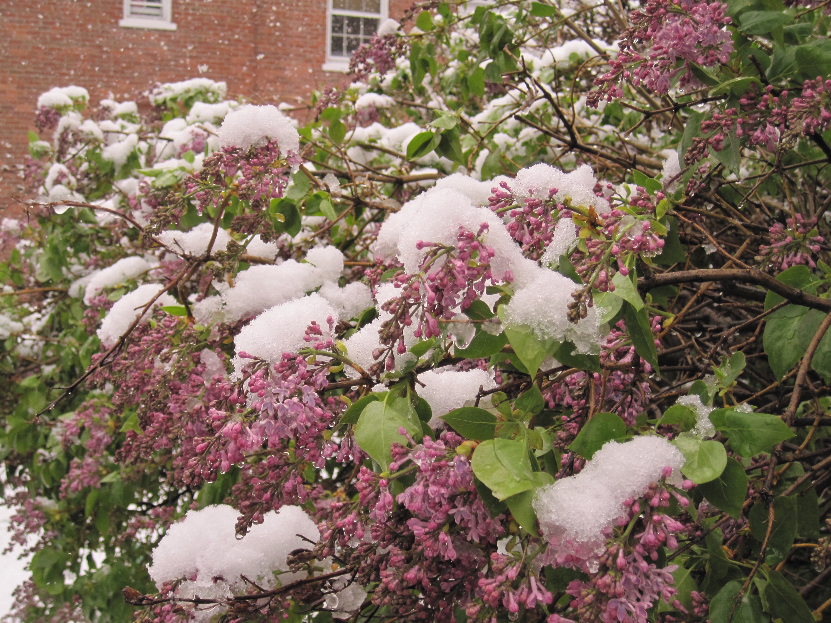
Snow covered lilacs in Burlington, Vermont during a 
record late heavy snowstorm in April, 2010.
Heres a mostly forgotten past weather event that really made a big impression.

The April, 2010  late season snowstorm on this post makes the snows we've had this month look like the lightest of flurries.

The snow on April 27-28, 2010 itself during that caused a lot of problems, as you might imagine. But the storm is especially memorable to me because of a decision I made during that weather event.  

Many people make fateful decisions during storms. Some work out quite well, some disastrously. The decision I made in that April snowstorm had little to do with the actual weather that day. I didn't fall victim to the storm, but I guess I fell in another sort of way.  

Here's what happened: 

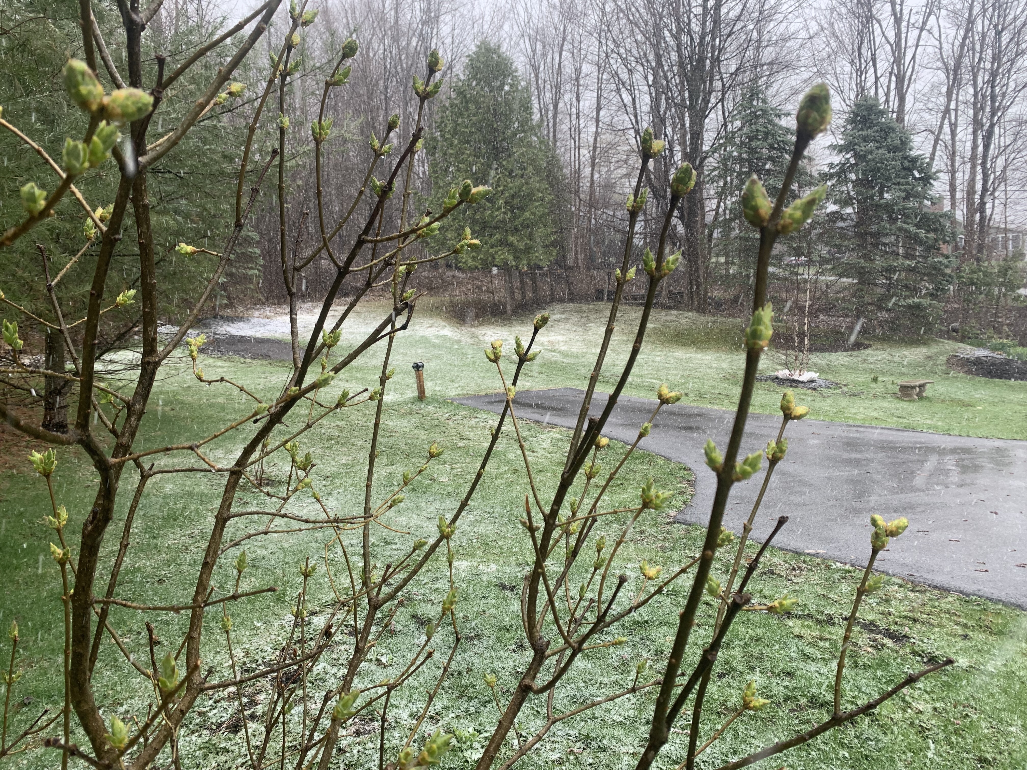
Spring, 2010 had been remarkably warm in Vermont.  

 March that year was the 6th warmest on record. In early April, temperatures soared to record highs of around 80 degrees. That April turned out to be the third warmest on record in Burlington.  Leaves and flowers blossomed weeks ahead of normal. By April 26, neighborhoods and lowland forests in northern Vermont were leafy and green, like mid-May usually is. 

But on April 27, 2010, a cold, wet storm struck the Northeast. During the day wet snow dusted lilac and rhododendron blooms in Burlington and surrounding areas.  A few sloppy inches piled up by late afternoon in a few locations. 

Then a decision entered the picture.  

By the evening of April 27, things, at least to me, were looking ominous for the northern Champlain Valley. It would get just a bit colder as the sun set, and heavier snow was moving in. I knew that Interstate 89 northbound up toward Georgia and St. Albans where I live would get treacherous. There would be falling branches and power lines in the heavy snow.

I worked at the Burlington Free Press at the time, and got off for day around 6 p.m. I was anxious to get home ahead of the worst of the storm. At that hour, I would make it before things got too rough on the roads. 

A leafed out, nearly blooming lilac bush, which had
been 12 feet tall, lies smushed to the ground during the
epic late April, 2010 snowstorm in St Albans,
Vermont. The lilac bush made a quick recovery and
is thriving to this day. 

Then my phone rang. It was Jeff. We'd been dating for a few months by then. I liked Jeff's company. He was smart and funny, but I had no commitments. 

 I wasn't ready for anything special. I even told him he wasn't really my type.  I guess I said that to keep my heart frozen, to protect myself from, I don't know what. 

Anyway. Jeff was on the phone. He'd just returned home from work to his South Burlington condo and found that his elderly, beloved cocker spaniel Rocky had died during the day in his living room.  Jeff needed somebody to be with him in that moment. 

So yeah, I wanted to get home ahead of the storm, but this to my mind was much more important. The decision was made. "I'll be right over," I quickly told Jeff.

I arrived and gave Jeff a long hug. Rocky was peacefully passed away in the middle of the living room rug.  He was posed as if he was running. Which would be the first time in years for that old, arthritic sweetheart. Rocky's head was posed looking slightly upward. It all seemed a picture of the moment when Rocky was called to cross that famous rainbow bridge.

Jeff talked about Rocky's life, how he loved to romp on the beach in Rhode Island and what a friend that pup had been. Jeff and I shed tears, laughed a little. I felt my heart melting as I took in what a warm, compassionate, wise man I was with. 

It was kind of like that old Grinch cartoon, where in the end, his heart got three times bigger, breaking the frame of the X-Ray picture. 

Jeff called his kind mother to tell her the sad news, and she managed to make him feel a little better, like all good mothers do. After that, Jeff said he was ready to be alone for the night

I drove home, it must have after 10 p.m. Sure enough, by then,  I encountered a real mess heading north once I got past Milton.  Interstate 89 was practically impassable, with squiggly tire ruts trailing in the deep wet snow on the highway .

Trees bent menacingly  over the edge of the ledges along the highway, ready to snap and fall on passing vehicles below.  St. Albans was an obstacle course of fallen branches and wires.  

Damage from a severe snowstorm in late April, 2010 in
St. Albans, Vermont.  Heavy wet snow fell on
trees that were already leafing out, causing serious damage.

I got to my house and the trees over the driveway were sagging so much they scraped against the roof of my truck. Normally those branches would have been about eight feet above the top of my truck.

In front of the house, the 12-foot tall lilac tree was smushed to the ground. The daffodils that had been blooming were nowhere to be found. 

I went to bed in the cold house with no power, and listened to the branches breaking all night in the woods in back of the house. Through all that, my mind wasn't on the storm at all. 

My mind was completely on Jeff.

I awoke next morning to a chaotic, snow plastered scene. Trees around my house bowed and sagged under the snow in defeat. Trees and branches were down throughout town. There was a full 15 inches of snow on my deck, making it the biggest storm of the winter. 

This was a Wednesday morning. The annual St. Albans Maple Festival was set to start in two days. And the city was littered with fallen trees, branches, wires, with smushed cars beneath all that. 

This being late April, the snow began to melt by mid-morning. Somehow, the city of St. Albans got things cleaned up just enough to pull off the festival. 

It was the most extreme late spring snowstorm I'd ever seen, but nature is resilient. That 12 foot lilac that was smushed to the ground in my yard popped back up later in the day. Only one of about two dozen main branches on it had broken. 

Within a couple days, the daffodils re-emerged and quickly returned to their sunny, happy selves, as if nothing had happened.

By that Sunday, the snow was gone, the temperature was back up to 80 degrees and the air was humid. 

Nothing had changed and everything had changed. The cycle of a Vermont spring continued on as usual. 

So what happened with Jeff? He and I will celebrate our 10th wedding anniversary this coming August.

VIDEO 

I put together a video, mostly photos of that April, 2010 storm in St. Albans, you can see it below. As always, to best view the video, click on the YouTube logo and then the arrow.

f you don't the video or the image of it on your device, click on this hyperlink to view.  Be patient. The video quality isn't great at the start of the video, but the photos are much better. 


Friday, April 29, 2022

Horrible Northern Hemisphere Summer Already Starting? India Heat, American, Siberian Fires

Record heat has engulfed India and Pakistan for weeks,
and it's only getting worse More than a billion people
will experience life-threatening heat this week.
 We're racing toward summer in the Northern Hemisphere, and if recent weather news is any indication, it's going to be another destructive, record breaking one in many parts of the world's northern half. 

With climate change, summers have gotten hotter and stormier, with terrible results. Witness the big wildfires in recent years,  the record smashing heat wave in the Pacific Northwest last year, all those hurricanes, and flooding in the southern and eastern United States last summer, you get the picture.

Summers have always brought heat waves, droughts, fires, flash floods and hurricanes.  But these issues are getting worse and more long lasting as the world warms.  

We don't even reach the month of May until Sunday, and summer type disasters are already beginning to unfold. The worst of them so far is in India and Pakistan.

INDIA HEAT

In most of India, the most intense heat waves each year usually strike in May, before monsoon rains cool things off marginally later in the summer. 

This spring, though has been off the charts in this densely populated nation. And now the heat is intensifying.'

As CNN reports more than a billion people - 10 percent of the world's population - are subject to life threatening heat over the course of the next several days. 

Once you get into May, daytime temperatures routinely exceed 100 degrees in New Delhi. But the forecast this week has that giant city approaching 120 degrees.

Overnight lows will only be in the mid-80s, which makes this heat wave especially dangerous. There's no chance for overheated people without air conditioning to cool down. The longer a heat wave grinds on, the more dangerous it becomes.

Extreme heat has already been going on for weeks, so people are already worn down.  Temperatures starting hitting record levels of over 100 degrees in March and consistently continued at record levels through April.

If by chance your heartless enough to not care if people in South Asia die in this heat wave this probably affects you, too.

India had hoped to boost grain exports to help make up for shortfalls in world grain supply due to the war in Ukraine. (India's motives to do this were aimed to both humanitarian and an economic windfall for the nation).

The long heat wave has stunted wheat crops in India, thereby tightening the world's supply and probably further boosting the cost of Cheerios at your favorite local supermarket. Not to mention a huge portion of the rest of your groceries. 

Don't like inflation? India's heat wave could just make it a bit worse than it already is. 

WILDFIRES

I've been blabbing on about wildfires pretty much all of 2022 so far in this here blog thingy. 

That shouldn't have happened. There should not have been many wildfires to talk about during the first four months of the year. Wild and forest fire season used to be predominantly a summer and fall thing, now it's year round. 

Almost a daily occurrence lately. High to extreme
fire danger in the Southwest today 

As a side note, wildfire and brush fire season in the Northeast is an exception to the summer rule. These fires peak up in the Northeast in the spring, before everything greens up. Brush fires have been reported this week in New York, Pennsylvania, New Jersey and Connecticut. 

Most of Vermont has a high fire danger today, due to very low humidity, sunshine and stiff breezes.

But, like I said, that's an aside. 

Today, for seemingly the umpteenth time this year, parts of the nation today are facing once-relatively rare extreme fire risk. This time, the worst fire risk is centered in parts of Colorado, Kansas and New Mexico. 

With drought conditions and little prospect for rain in much of the west, wildfires have gained a stronghold weeks or even months before what was once considered normal. New large fires broke out in recent days in New Mexico, Colorado, Florida, Nebraska, South Dakota, Oklahoma and Texas. 

The yearly spate of wildfires in Siberia have already started, also earlier than normal.  With the Russian military distracted by their war crimes and failures in Ukraine, officials fear there won't be the personnel to deal with those Siberian fires as they inevitably intensify over the summer, notes the Washington Post. 

The Siberian fires are intense enough to bring hazy skies from the smoke to parts of the western United States this week. 

CALIFORNIA WATER EMERGENCY 

Also this week, about 6 million Southern Californians were ordered to reduce water usage and limit outdoor watering to once a week due to the drought there. 

The winter rainy season is sputtering to a close out there, with not much rain having fallen. The Metropolitan Water District of Southern California said in a statement that "supplies have been so drastically reduced over the past three years that in some parts of the region, we simply don't have enough water to meet normal demands this year."

All the problems I've cited above are just the opening salvo in what promises to be a long, hot, destructive summer. Maybe I'm wrong and I hope I am, but we're already not off to a great start.


Thursday, April 28, 2022

March Was World's Fifth Warmest Month

Once again, too much red in the world.  March was Earth's
fifth warmest on record. 
 At least the world's (overheated) climate has been consistent for many months now. Too bad the consistency isn't a good sign.  

Globally March was the fifth warmest month on record. This follows the trend of the past several months to a year, in which pretty much every month has ranked somewhere between fourth and sixth place in the hot month derby. 

According to NOAA's National Centers for Environmental Information:

"The seven warmest Marches have occurred since 2015, while the 10 warmest Marches have occurred since 2002 March, 2022 also marked the 46th consecutive March and 447th consecutive month with temperatures, at least nominally, above the 20th century average." 

Overall, the first three months of 2022 were also the world's fifth hottest on record. 

 I guess we can at least partially blame La Nina for this strange consistency. La Nina is a periodic cooling of eastern Pacific Ocean water, especially off the west coast of South America. During a La Nina, the earth's temperature tends to cool a bit. 

This La Nina has lasted an unusually long time. Most La Ninas last from nine to twelve months. This one has gone on for two years and is expected to last at least a few more months. 

I wonder what will happen when we eventually flip over to the opposite phenomenon the El Nino. Unlike El Nina, the Nino tends to warm the global atmosphere somewhat, with or without human-induced climate change. 

That could mean more record heat for the planet, which means more weather extremes. Perhaps more deadly and more costly weather disasters than we're already experiencing. 

So far this year, insurers who track particularly expensive weather disasters with losses of $1 billion or more ave noted two such calamities this year through March.  That's about on pace with the rate of such disasters in recent years, anyway. 

The two mega-disasters in early 2022 were a huge flood in eastern Australia that caused about $4 billion in damage, and Storm Eunice, which caused about $4.1 in damage across western and central Europe, mostly due to high winds.  

Vermont Snow Continued In Spots Overnight; Snow Pretty Much Over Chill Isn't

Still some dustings of snow in my St. Albans, Vermont 
gardens this morning.
Judging from webcams this morning, it looks like there was a pretty widespread one to two inches of snow overnight in northern Vermont, at least at elevations above about 1,500 feet. 

Some high elevation roads, like Route 17 in Buels Gore and Route 242 in Westfield, actually looked a bit icy early this morning, so be careful if driving up in the northern Green Mountains early today.

The summit of Mount Mansfield looks like they had about four inches of new snow by late Wednesday afternoon, so I bet the highest peaks of the Green Mountains clocked in with a good six inches or more of snow out of this. 

Lowlands look almost snow-free, but there's still a dusting of snow on the ground outside my window in St. Albans. Places like Williston and Waterbury also received a fresh dusting of late April snow. As of 6 a.m. it was still snowing a little in places like Montpelier and Morrisville. Temperatures region-wide were near or a little below freezing. Brrr! 

This kind of snow is certainly not unheard of this late in April, it is kind of late for the low elevations to receive any snow. Nowhere near a record, but still -- late.

The good news is that snow showers in the hills should wrap up pretty quickly this morning.  The bad-ish news is it will still be windy and chilly around here for the next couple of days. 

From my northwestern Vermont perch in St. Albans, I could see a sharp line between overcast and clear skies well off to my northwest as of 6:30 this morning. 

That clearing line will probably advance toward and likely into Vermont today. However, that lingering storm that brought the snow to us is still sitting and spinning to our east.  That will give us a day of haves and have nots in Vermont. 

Vermont Agency of Transportation webcam showed 
a trucker dealing with an unseasonably slick 
Route 242 in Westfield, Vermont early this morning.

Somewhere, probably over or near Vermont, that clearing line will stall. Places to the west of that line will have a bright, sunny, but windy and chilly afternoon, but the sun will make things feel less bad. Places to the east will be stuck under clouds, and be even cooler, but still windy. 

I'm not sure where that sunny to cloudy border will end up, but places west of the Green Mountains, and in the southern Connecticut River Valley will have the best chance at sunshine. 

At this point, it looks like the stuck storm to our east will throw some extra clouds our way tomorrow, so we'll call Friday variably cloudy.  On Saturday, that storm will start to grudgingly pull away to the east, which would give us some more sunshine, but still a stiff north wind and temperatures about 10 degrees on the chilly side of normal.

We're still looking toward Sunday to firmly break back out into full fledged spring weather. 

Wednesday, April 27, 2022

Once Again, Snow Over-Performs In Parts Of Vermont Again Today

A spring snowfall surprised me in St. Albans, Vermont this
afternoon. As you can see, accumulation wasn't much, but
I'm still hoping this is the last snow until November.
Parts of Vermont once again today got more snow than forecast, but it was a pretty localized event. 

It snowed all afternoon here at my hacienda in St. Albans, Vermont, perched part way up St. Albans Hill at an elevation of about 630 feet above sea level. Light rain showers had been expected here, and that was the state of affairs until shortly before 1 p.m. when I began to notice snowflakes. 

Snow then came down rather heavily at times through the afternoon. There's a slushy coating on the ground as I write this. So far, I'm calling it 0.3 inches of new snow. I thought we were done with this! But Vermont weather always surprises.

Meanwhile, just a little south in Milton, Colchester and Burlington, people wondered what all the fuss was about. It didn't even start raining there until late afternoon, never mind snow. 

In northern New York and northwestern Vermont, it appears a pocket of deeper moisture swung around down from Quebec across this area. That meant heavier precipitation in this little corner of the North Country. This heavier precipitation helped cool the air, so snow aloft made it down to the surface. 

For much of the afternoon, many relatively high elevations of the Green Mountains were still getting rain, mixed with a little snow. Although it was consistently snowing across the mountain peaks. Vermont Agency of Transportation web cams showed just rain along high elevation Route 17 in Buels Gore.  Route 302 up high in Topsham was just changing to snow as of 4:15 p.m.

Route 105 in Jay was solidly in the snow, though, and it looked like at least an inch of accumulation there by 4 p.m. 

The expectation, or at least the hope, is the precipitation in northwest Vermont will gradually become more oriented to higher elevations as the night goes on. That would be good, because another late season heavy snow will cause more damage to my gardens. If the precipitation lightens up in low elevations, as expected, it might actually go back to rain briefly before turning back to flurries. 

As I wrote this at 5 p.m. it was still snowing in St. Albans, but it had pretty much tapered down to flurries by then.  Radar trends seemed to be indicating the snow was indeed starting to become more focused toward the mountains, and was trending a little lighter in northern New York and the northern Champlain Valley  

A surprise spring snowfall dusts a perennial garden in
St. Albans, Vermont in a most unwelcome way.

That the snow was beginning to spread into the central and northern Green Mountains pretty well by late afternoon. 

That part was expected. I wouldn't be at all surprised if the summits of the central and northern Green Mountains have storm totals of four to six inches, maybe even more, by tomorrow morning. 

The stalled storm that is causing this wintry weather will pretty much stick around through Saturday, but luckily, things won't stay as bad as they were today, at least in some parts of Vermont. 

Snow showers will go on every day through Saturday in the Green Mountains, but they will be relatively light and won't add much to the accumulation  up there.  Valleys, especially in the northern half of Vermont ,stand the chance of a few rain drops or snowflakes daily into Saturday. But that's about it. 

Still, there will be quite a few clouds around temperatures will stay well below normal and gusty northwest winds through Saturday will make it seem even colder. 

Forecasts still call for weather more in keeping with the season starting Sunday. 


Snow Makes A Return Visit To A Vermont Spring

Large fallen branches still litter a South Burlington lawn 
on Tuesday, a week after a wet spring snowstorm damaged
trees in much of Vermont. Tree trimming companies
are swamped with requests for help from storm damage
A little over a week after a wet snowstorm trashed lots of trees and power lines across much of Vermont, the Green Mountain State is facing more snow today through tomorrow. 

This time, thankfully, there will be much less snow for most places than what we had on April 19. Some places won't get any at all. 

But, we certainly have another interruption of spring to talk about, as cold north winds, clouds and low temperatures won't put you in the mood to dance with the daffodils for the next few days. The snow will mostly be in higher elevations, and the Northeast Kingdom.

The culprit is a storm in both the lower and upper levels of the atmosphere blossoming near Maine and New Brunswick. It's pulling cold, wet air around the back side of it. Atmospheric steering currents over the Atlantic are all gummed up at the moment, so that storm will sit and spin now to Saturday, keeping us chilly, mostly cloudy, and at times, snowy. 

Most of the snow we do receive comes this afternoon and tonight. Snowflakes will eventually make it down to many valley floors overnight, but if anything accumulates in the lowlands, it will just be a slushy coating on the grass.

At and above about 1,500 feet above sea level in northern Vermont, there's a good chance of seeing one to three inches of snow. Some of the highest elevations and a few spots in the Northeast Kingdom could see four or five inches, says the the National Weather Service in South Burlington. 

There might even be enough snow for an isolated power outage or two, but we won't see anything like the scale of last week. 

The Northeast Kingdom missed out on a lot of last week's snow, so I guess it's their turn. 

For all of us though, we'll endure some March like weather, especially today through Friday. That means highs only in the 40s, with a few upper 30s in the coldest places in the Northeast Kingdom. Overnight lows for the next few nights will be near or below freezing.

Since the storm will be stalled near New Brunswick, the further east you go now through Saturday the worse the weather will be.  Northern New York might actually be fairly sunny starting tomorrow.  Vermont's Champlain Valley will see some peeks of sun occasionally, but the Northeast Kingdom looks gloomy.

Things will start to improve Saturday  and especially Sunday, when that pesky storm finally gets a good shove out into the Atlantic Ocean. By Sunday afternoon, temperatures should be in the 50s to around 60, which isn't far from normal for this time of year.

Beyond that, the weather looks like it will be a typical spring pattern of changeable weather, with nothing too extreme in the offing.

Meanwhile, the fallout from last week's storm continues in Vermont. Tree companies are slammed with business with wait times to remove fallen and damaged trees extending into weeks.  One victim of fallen trees said the chain saw guys couldn't even look at their damage the day and day after the storm because there were prioritizing all the houses and cars damaged by the trees.

The McNeil Waste Wood yard in Burlington, where people can bring their clean wood, such as branches and broken trees, had an immense pile of storm damage as of Wednesday. The attendant there said it's been incredibly busy since the storm. 

Tuesday, April 26, 2022

North Dakota Weather Exhaustion. Now The Serious Flooding Sets In

The National Weather Service page for Bismarck, North
Dakota on Saturday had every kind of weather alert
imaginable from blizzard to tornado warnings. 
 Readers of this here blog thingy have surely noticed my fascination with North Dakota of all places in the past few weeks. 

It seems like all the extreme weather in the world has been ganging up on this state, and in parts of Manitoba across the border in Canada.

As the Saturday screenshot from the National Weather Service office in Bismarck shows, almost every kind of bad weather imaginable was hitting the state. 

This include a tornado warning, a tornado watch, severe thunderstorm warning, flood warning, flash flood warning flood advisory, winter weather advisory, blizzard warning and high wind warning. 

About the only thing I'm not seeing there is hurricane warnings or tsunami warnings. The weather chaos has now evolved into a flood problem in eastern North Dakota, and the flooding might spread into blizzard-weary western parts of the state this weekend. 

According to the Grand Forks Herald: 

"In Greater Grand Forks, the weather service is predicting the Red River will crest at 48.5 feet mid-week. The river has already seen a quick jump - just before noon Saturday, April 23 he Red was at 28.93 feet; by early Sunday afternoon, the river was up to 39.7 feet.  

The expected crest on Wednesday would be the sixth highest on record at Grand Forks, where records go back to the 1880s.

The highest Red River flood at Grand Forks, and by far the most devastating was the 54.35 foot crest on April 22, 1997. 

During that flood, most of Grand Forks, including downtown was flooded. Fires broke and destroyed eleven large downtown buildings, including the building housing the Grand Forks Herald newsroom. The paper managed to keep publishing anyway. 

This obelisk in Grand Forks, North Dakota measures flood 
heights on the Red River. The river is forecast to be 
just a few feet lower than the all-time record high
crest at the top of the obelisk, from 1997

Even if the Red River unexpectedly crests higher than forecast, it won't be as devastating as in 1997 because of $1 billion in flood control projects along the river since then.  

This year's episode of flooding gets worse the further north you go. The Red River flows northward along the North Dakota/Minnesota border into Canada. Near Oslo, Minnesota. the river is expected to crest less than half a foot below the all-time record high. 

Widespread flooding has also advanced into Manitoba, Canada. Weather continued to create problems for people battling the floods.  Normal high temperatures in the region this time of year are in the mid-50s.  Monday's highs were only in the mid-20s.  

Though it will warm up somewhat during the week in the flood zone, a new, wet storm is expected to hit Friday and over the weekend. 

Further west, snow and cold is the problem.  Since April 12, it's only gotten above 50 once in Bismarck ,North Dakota. This in a city that normally has high temperatures of around 60 degrees this time of year. 

However, flooding is a good possibility even in western North Dakota as the next storm this weekend appears more likely to cause heavy rain, and not another blizzard.

I'm sure North Dakota is lovely, in its own way, but I'm sure glad I don't live there this spring! I'd rather take the mud underfoot, the drizzly days and snow flurries we've had in Vermont for sure. 

Monday, April 25, 2022

Snapped Tree Gets An Odd, Dying Advanced Spring; Rest Of Us To Enjoy Slow Greenup

This tree in Burlington, Vermont snapped in last week's
snowstorm. The sun-warmed gravel it was resting on
caused the tree to leaf out before all the others. 
However, the tree obviously won't survive.
 I thought the photo in this post was slightly interesting, so I figure I'd share it and what went on.

The tree in Burlington snapped under the weight of heavy snow last Tuesday, with the bottom part of it hung up on a fence and the top resting on a gravel parking lot. 

The warmth of the sun on the gravel in the days following the snow warmed the treetop up considerably. so it leafed out before any other tree in Burlington did. 

Of course, it was a dying gasp of greenery, since the tree is dead and will presumably be removed soon by whoever owns the parking lot. 

Other than honeysuckle shrubs and maybe a few willows, trees had not leafed out at all around the Champlain Valley as of Sunday. 

The National Phenology Network tracks the spring advance of green-up. In the map red areas are where spring is running ahead of average and blue is where it's running behind. White means spring hasn't hit yet, or the advance of spring is right around normal.  At least the greening of the earlier plants, like honeysuckle. 

Red is showing up in parts of Vermont on the map as of Sunday, as those earliest shrubs and plants are trying to leaf out. So spring is still earlier than average so far, but is not running as far ahead of schedule as last year. 

None of the bigger trees in the area showed signs of green as of Sunday. But some trees on Sunday   appeared to be on the cusp of greening up. A warm day today will probably coax a touch more greenery. Not to mention encourage your daffodils, tulips and forsythia to keep blooming. 

The National Phenology Network shows the Northeast
having an earlier than usual schedule for early
leafing plants. Vermont is just beginning to see 
green, and is a little ahead of normal. 

A mild night and a seasonably mild day Tuesday should encourage a little more spring growth, but things will stall for the rest of the week under a cool, breezy and cloudy weather regime. 

Daytime temperatures Wednesday and Thursday will stay below 50 degrees, which is a good ten to fifteen degrees cooler than average.

We could get some showers late tonight and the first half of Tuesday, but amounts will be very light. Unfortunately, we're due for light rain, and yes, snow showers Wednesday and Thursday. It won't be anything like last Tuesday, though. Light accumulations should be limited to higher terrain

The next chance of anything resembling springlike weather will come about next Sunday or so..

Sunday, April 24, 2022

South African Flood Likely Worst In Nation's History

This AP photo of shipping containers swept away by
water indicate the power of the recent South African flooding.
 I'm kind of surprised that a disaster this big has received almost no attention. 

A massive storm has hit parts of South Africa in the past few weeks, causing an epic flood that resulted in at least 440 deaths. 

The Washington Post and several other news outlets did report on this calamity, but the South African disaster did not garner big-time headlines or huge amounts of notice. 

The Associated Press on Tuesday said 448 people have been confirmed dead in the flooding and mudslides and another 40 or so people are still missing. 

The worst of the flooding  hit around the city of Durban and the surrounding KwaZulu-Natal province, the AP reports.  

The extreme rains caused huge landslides that swept buildings down hillsides and buried an unknown number of victims.  

According to The Washington Post:

"Rainfall was primarily caused by subtropical storm Issa, which was named on April 12 off the coast of South Africa. More than 200 millimeters (7.9 inches) of rain fell in 24 hours, with some stations reporting more than 300 millimeters (11.8 inches) as of Tuesday."  

That 11.9 inches of rain within 24 hours fell on Durban, South Africa.  That was four times the amount of rain the city normally sees in a full month. On a single day! That stat is incredible.  

In and around Durban, at least 40,000 people remain homeless due to the flooding. Damage to infrastructure alone, never mind homes and businesses is at least $400 million. 

South African President Cyril Ramophosa promised that government money for flood victims will not go to corruption, but more than a few South Africans are skeptical. 

The AP reports: 

"Ramaphosa's remarks come after widespread graft was uncovered by the state's Special Investigating Unit in state funds that were supposed to help the nation respond to the COVID-19 pandemic. Former Health Minister Zweli Mkize resigned after the investigation found that businesses linked to his family benefitted from inflated COVID-19 contracts from his department." 

Like many other parts of the world, South Africa has in recent years been rocked by dramatic and dangerous weather extremes.  Climate change is at  least partly responsible for these events. 

The city of Cape Town, South Africa, with a population of about 4.7 million (including my dear friends Denis and Michael, hi there!) almost completely ran out of water in 2018 in the infamous "Day Zero" drought.

Cape Town was not seriously affected by the recent flooding as it's around 800 miles from Durban. But rains have helped the city's reservoirs recover, at least for now. 

Saturday, April 23, 2022

Fires, Blowtorch Weather Conditions, Severe Storms Make West A Strange, Dangerous Place.

Satellite photo from Friday evening show big
thunderstorms in the central Plains (the white blobs)
and dust storms blowing from New Mexico all the 
way north into western Nebraska
What I can only describe as blowtorch weather swept the Plains and and Southwest Friday contributing, as expected, to wild and rangeland fires, dust storms, and record heat amid incredibly arid conditions.

Just east and north of the hot zone, hail, strong winds, a few tornadoes and flooding were an issue. I feel like I should follow up on what came of those awful forecasts I wrote about yesterday, so here goes: 

Dust storms, smoke, heat and strong winds made for a trying day from New Mexico to Colorado and Nebraska all afternoon. 

A good example of this is the afternoon weather in Las Vegas, New Mexico.   At one point Friday, the wind in Las Vegas was gusting to 72 mph and the humidity was just 8%.  Wildfires forced evacuations nearby.  

Fires forced evacuations elsewhere in New Mexico, Colorado, Kansas and Nebraska. 

At least thirty homes burned this week in wildfires near Flagstaff, Arizona. A new fire broke out in Colorado Springs amid single digit humidity levels and winds gusting over 60 mph. Firefighters somehow managed to contain that blaze.

Residents of some small southwestern Nebraska towns also beat a hasty retreat from wildfires there.

Fire danger remains high today in the Southwest, but things should temporarily get better for the next few days. However, there are signs more fire trouble looms toward the end of next week.

This has been a bad fire year already, and with summer coming and drought continuing in the West, it will only get worse. 

According to The Weather Channel:

"Wildfire activity in the U.S. is well above average so far this year, according to the NIFC. More than 20,000 fires have scorched about 1,300 square miles of land since January 1. That compares to a 10-year average of 13,390 fires and about 980 square miles burned."

The heat in the Plains and parts of Colorado Friday was impressive, too. 

Temperatures into the low 90s on Friday reached as far north as Yankton, South Dakota.  It was still in the low 70s there at dawn today. 

Denver reached 89 degrees on Friday, its hottest April day in 30 years. 

Meanwhile, beleaguered North Dakota continues to have kitchen sink weather, meaning pretty much everything, and all of it bad. Heavy rains have triggered flooding in eastern parts of the state. Severe thunderstorms and perhaps even a couple of tornadoes are possible today in southeastern North Dakota. Western North Dakota is having a blizzard. 

Central parts of that state are having heavy rains and flooding, changing to snow and blow snow over the weekend. On the bright side, North Dakota is one of the few western states not under threat from wildfires at the moment. 

At least five tornadoes in Kansas and one in South Dakota were reported. There were also several reports of baseball-sized hail in the Plains as well.   

VERMONT CONDITIONS

As wet as it has been, we actually have a bit of a fire danger here in Vermont today. This time of year, before things green up, the intense April sun can dry old grass, leaves and undergrowth out quickly, even if the ground beneath all this remains squishy.

Some of the driest air masses of the year often come through New England in April and May. Even though the bouts of dry air don't usually last long, the low humidity can contribute to conditions friendly to brush fires.

Though winds will be rather light today, the dry air and sunshine make this NOT the day to burn your brush pile or be careless with cigarette butts and such. 

At least we're getting a break from the wet, dreary weather this weekend.  It's not all that warm, but it's not North Dakota either.  After a mild Monday, it's back to the rain, cool air and gloominess for a good part of the upcoming week. 

Friday, April 22, 2022

Another Round Of Plains/Rockies Wildfires, Blizzards, Storms

Huge area of the Southwest, in red and especially
pink are at high risk of uncontrollable wildfires todaiy.
While we in Vermont haven't exactly had the nicest spring weather lately, at least it hasn't been as dangerous as it's been in much of the Plains and parts of the Rockies. 

Each round of bad weather seems to get worse and worse, and we have another nasty situation out there today. 

The biggest threat is wildfires. This time, the prime zone for those fires are a little further west that previous iterations.  When NOAA's Storm Prediction Center puts out an "extremely critical fire" alert you know it's serious.

Today's "extremely critical" zone is also much bigger than you typically see, encompassing large chunks of New Mexico and eastern Colorado.

This danger zone includes Denver and Boulder.  People there are probably especially nervous, given how they're just beginning to recover from the fire storm that roared through Boulder suburbs in late December.

That wildfire was the worst in Colorado history, having destroyed around 600 homes. 

Already, large wildfires are burning near Flagstaff and Prescott, Arizona, forcing hundreds of people to evacuate. Other large fires are currently burning in New Mexico.

April is not normally a season for big fires, especially in Colorado. The Front Range area often has snow or cold rains this time of year as storms often develop there and head east, causing severe weather in the Midwest. 

Those storms are forming this year, but going further north than usual, leaving the southern Plains and Colorado and New Mexico parched.

Today, yet another storm is forming, again somewhat north of where they usually go. Temperatures in the fire zone are expected to get into the 80s and 90s, relative humidity will crash to the single digits, winds will gust past 60 mph over ground and vegetation that is at record levels of dryness.'

You see the problem.

Additionally, the storm is setting up a dry line in the central and southern Plains.  As we noted recently, a dry line is pretty common in the spring. It's a sharp north/south boundary between very humid air to the east and hot, very dry air to the west.

Supercell thunderstorms and tornadoes often form along this dry line.  Today, that dry line will start out near the Colorado/Kansas border and push east. What are known as low precipitation, or LP supercells are expected to form.

LP supercells are incredibly dramatic looking, spinning thunderstorms that form striking clouds and sometimes tornadoes. These clouds are so visible because of the lack of rain with them. But LP supercells often spit out quite a few lightning bolts. With the lack of rain and the lightning hitting parched areas, the potential for fire starts is pretty damn big.

DAKOTA BLIZZARD AGAIN

North Dakota is also having an incredibly rough spring. One of the worst blizzards in the state's history struck on April 12-14, and another winter storm hit around April 17. Within that stretch, temperatures his record lows of between zero and 5 above.  

The Dickinson, North Dakota Police Department digging
out from an epic blizzard earlier this month. Another
blizzard is forecast to hit parts of that state this weekend.

Now, another blizzard is set to hit the western part of North Dakota over the weekend with another eight to 15 inches of windblown snow.  The eastern half of the state can expect some heavy rain before precipitation changes to snow. That could cause flooding as runoff from rain and melting snow overwhelms ditches. 

The Red River along the North Dakota/Minnesota border is swelling fast and at least moderate flooding is expected. This will have to be watched carefully.  April, 1997 had similar weather to this year. The Red River in 1997 rose to record levels devastating the city of Grand Forks, North Dakota.

SEVERE WEATHER

Those LP supercells I talked about earlier in this post are expected to become better organized as they move east. Possible tornadoes, destructive straight-line winds and ginormous hail are possible in a stripe from central South Dakota to the Texas panhandle today

Tomorrow, the severe threat moves a little east, involving a stripe that envelops most of Minnesota and extends all the way down to central Texas.

Overall, the severe weather threat today and tomorrow is pretty typical for this time of year. North Dakota often gets blizzards in the spring but this year is quire unusually bad.   The level of fire danger in the southwest is really off the charts for this time of year. 

VERMONT IMPACTS

As is usually the case, we in the Green Mountain State are bystanders to all of this. The weekend will be dry and cool, especially tonight and tomorrow. Everyone will have a frost and freeze tonight, and it'll only get up into the low 50s Saturday afternoon.

Sunday will be a bit warmer. We're still expecting a quick squirt of rather warm air Monday before things turn gloomy again later Monday through at least the middle of next week. 

Thursday, April 21, 2022

Atmospheric Pattern Goes Negative, We Get Chilly As A Result

A gloomy, chilly spring day, May 3, 2019.  A weather 
pattern setting up now is forecast to give us more than
our fair share of weather like this. 
Something called the negative NAO is going to ruin your spring. For a while, anyway. 

Our upcoming bout of generally chilly spring weather is brought to you by a negative phase of something called the North Atlantic Oscillation.

This refers to changing weather and pressure patterns in the North Atlantic.  When it goes negative we get colder. 

It's now going negative.  A negative NAO means that high pressure takes residence up in and near Greenland. This suppresses the jet stream southward, especially in eastern North America. When the jet stream slips south, we get colder. 

In the winter, a negative NAO means subzero weather and a risk of nasty nor'easters in New England. 

This time, it's all happening in late April and the opening week or two of May, so it won't be a dramatic as a negative NAO in the winter.  It'll just be chilly most days between now and at least the first week in May. Not every day will be colder than normal, but the trend will go in that direction. 

Most, but not all of the time, it doesn't rain (or snow) all that much in a negative NAO around here during the spring. We get a lot of cloudy days and light showers, but blockbuster storms tend to be lacking in this regime. 

The very cloudy weather with this pattern in spring is in large part due to the interaction of the strong spring sun and the nippy atmosphere. The sun heats the ground strongly causing updrafts. Those updrafts form lots of clouds as they rise into the colder air.  The colder air causes moisture in the updrafts to condense, and you get clouds.  

This weather pattern does have its benefits, at least elsewhere in the nation.  The negative NAO tends to suppress severe thunderstorms and tornadoes in the Midwest. That's a good thing as we head toward the peak of severe weather season.

This doesn't mean there won't be tornadoes. It just means there will be fewer of them. 

The weather pattern is also causing some late season rain and mountain snow in California. It won't be a huge amount of precipitation out there, but anything will come in handy after a remarkably dry second half of winter in much of the western U.S.

Back here in Vermont, the next few days will be only slightly cooler than average. We will get a quick squirt of warmer than  normal air Monday and Monday night before we settle into the cool pattern again.


Wednesday, April 20, 2022

Helium, Gas Shortage Worsens For Weather Balloon Launches, Could Make Forecasts More Iffy

A helium shortage has curtailed some weather balloon 
launches, raising questions about whether this
will affect forecast quality in some situations.
 A helium shortage has worsened - at least for now - the ability of some local weather offices to launch critical atmosphere-monitoring balloons.  

This party-pooper development not only threatens some balloon-festooned celebrations, but it could mess up your weather forecast, at least a little.  

I first brought this up in March 2 post, when at least one National Weather Service office was curtailing weather balloon launches because of the shortage. 

These weather balloon launches are important because they carry a box of instruments called a radiosonde. That device collects data that is ingested into computer forecasts models to predict pretty much all kinds of weather. 

True, weather balloons seem anachronistic in this age of weather satellites and whiz-bang technology. But they do add to the boatloads of data needed to make accurate forecasts. 

The National Weather Service says the limited launches won't affect the quality of weather forecasts, but other meteorologists aren't so sure.  The Washington Post checked in with a number of meteorologists who questioned that assertion by the National Weather Service.  

 Weather balloon launches seem anachronistic with all the satellites and technology we have to monitor the weather. 

As the Washington Post reports: 

"Weather balloons are especially useful in severe weather or wintry precipitation environments because the data they collect can offer detailed insight about temperature profiles with altitude that can't be collected via radar, satellite or a ground-based observation network." 

Severe thunderstorms and winter storms are especially tricky to forecast, so the balloons are a great added tool to accurately predict those events. 

There's two bright sides to this problem that make it less bad than it could be. 

A minority of the 101 sites in the United States and the Caribbean that launch weather balloons use helium. The rest use hydrogen. 

However, you can't use hydrogen in crowded areas with lots of people, basically anywhere near a lot of occupied buildings. Think Hindenburg. Hydrogen very easily goes BOOM. The Hindenburg airship was full of hydrogen and that sure didn't end well. Which means you don't want to risk a calamity with hydrogen when a lot of people are wandering around close by. 

Another bright side is the helium shortage might ease within the next few weeks. That would make limited balloon launches a temporary issue.  The Washington Post said several sites were able to sort out some of the problematic gas deliveries, but it will take time until actual gas deliveries resume. 

Overall, then, the Great Helium Crisis of 2022 means a few of your trickier weather forecasts might be a little less accurate than they otherwise would be. Most of the time, your National Weather Service forecast will be quite accurate.  It almost certainly won't rain on your parade tomorrow if the NWS is calling for clear skies. 

Still, the more accurate all the forecasts are the better. Here's to hoping the helium shortage eases soon! 


Spring Is Resuming Today, But Why We Got That Huge Storm And What Are Its After Effects?

Trees on the verge of collapse during yesterday's wet
snowstorm in St. Albans, Vermont
 For the second year in a row, much of Vermont received a surprisingly strong winter storm in the third week in April. 

In both cases, the snowstorms hit during a spring that was earlier than usual, though 2021's version featured a much earlier spring than this year. 

April Winter Storm 2022 surprised forecasters as snowfall was much heavier than predicted. This storm had a high bust potential to begin with. 

Temperatures were just a degree or two colder than forecast, and the atmosphere was only subtly more primed for heavy snow than predictions ahead of the storm.

Meteorologists with the National Weather Service in South Burlington, and local TV meteorologists got the basic premise of what would happen correctly well ahead of the storm. 

They knew that overnight Tuesday and into Wednesday, a pretty hard thump of snow would move south to north across Vermont. And that's what happened. However, expectations were that valleys would be warm enough so that there would only be an inch or so of snow before things changed to rain. Mid and high elevations would get three to six inches of snow, which is what happened. 

However, the cold air hung on long enough so that during the period of heaviest precipitation, the snow never changed to rain, at least in western Vermont. So that inch of snow turned into three to six inches, with locally higher amounts. 

I also think the precipitation was a little heavier than forecast. That rush of  heavy snow coming down from aloft might have helped cool the air near the ground just a bit, so the snowflakes managed to land without turning to rain first.  

As expected, eastern Vermont had less wintry weather than the western half of the state, as the storm took an inland track northward through central New England. While areas west of the Green Mountains were stuck in the 30s early Tuesday afternoon, it go up to a seasonable 55 degrees in St. Johnsbury.

Meteorologists had said before the storm that central New York and the Adirondacks would have the heaviest snow of this storm and boy did those areas deliver! 

Damage from heavy, wet snow in St. Albans Tuesday.

Amounts were as high as 18 inches in the towns of Bleecker and Virgil, New York. 

THE STATS

Believe it or not, at least in Burlington, this wasn't even a record high snowfall for the date. The National Weather Service in South Burlington measured 4.2 inches of snow Tuesday. But on the same date in 1925 there was a six inch dump. 

However, I only found two days in the roughly 140 years of records in Burlington with more snow later in the season than yesterday.  There was 4.3 inches of snow on April 20, 1953 and 4.9 inches on April 23, 1993. 

Of course, other parts of Vermont have had frequent bouts with even deeper snow into the month of May. 

Gusty winds mixed with the wet snow in some areas contributed to the power outages, which peaked at around 22,000 in Vermont yesterday. As of 6:30 this morning, about 2,100 customers were still without electricity. 

Gusts as high as 54 mph were reported in Proctor. Much of the Northeast Kingdom had strong gusty winds as well.This led to a tragedy on Lake Seymour in Morgan when two young men died when their canoe overturned.  According to VTDigger, the two set out on the lake in the canoe when strong winds arose, causing waves and areas of slush that overturned the boat.  The two tried to swim to shore, but drowned. 

There was a lot of water in Tuesday's snow. Melted precipitation was 1.11 inches in Burlington, which was a record for the date. This puts the month of April solidly wetter than normal, but not remotely near any records.  Most other areas in western and central Vermont also had about an inch of precipitation yesterday. 

YOUR GARDEN

This Korean lilac in my St. Albans, Vermont yard looked
completely smushed to the ground and potentially
ruined by heavy wet snow, but as the snow melted
the branches bounced back into place and this
lovely shrub was completely unharmed by the snow.
Damage to early season gardens will not be as bad as during another bout with snow and cold a year ago, on April 21-22, 2021.

The only real damage this time around will be if the heavy snow broke branches on any of your trees or shrubs.  I do have minor damage in my gardens from snapped and bent branches, but nothing extensive.

The good news is your early hardy perennials and tree buds are fine. Temperatures during the storm bottomed out at around 32 or 33 degrees, which is not cold enough to harm anything. 

Last year, buds and flowers were more advanced than this year, so lilac, crabapple and other flowering trees and shrubs suffered some damage last April as temperatures crashed well into the 20s just as these plants were starting to bloom.

FORECAST

A little more snow fell overnight in the mountains, judging from radar reports and web cams that show snow covered roads at high elevations. Snow showers lingered in the mountains all night, so I bet there was several inches of snow at summit level, but little if anything below 1,500 feet.

Jay Peak reported an additional six inches of snow overnight for a storm total of 15 inches. 

Runoff from the snow melt will probably put the Lake Champlain lake level at just under its flood stage of 100 feet above sea level.  It will be mushy underfoot for a few days once again.  

Strong south winds Thursday might cause some minor splash over and erosion problems along some shorelines in the northern half of Lake Champlain. 

To help dry things out, we are expecting very little rain in the next week or so. It'll amount to just a few hundredths of an inch to a quarter inch now through next Monday which is next to nothing. 

Though things will get decidedly more springlike than yesterday, we've fallen into a pattern that will keep us mostly cooler than normal at least into early May. Not every day will be on the cool side, but that will be the trend. Too bad, I like warm spring days. 

In the near term, today will be blustery and quite cool, even with increasing afternoon sun. Highs will only make it into the upper 40s, which is about 10 degrees on the cold side. Still, the remaining snow on the ground should disappear for most of us, unless you're up high. 

It stays cool through the weekend, with some frosty nights (not damaging for what's out there now). Afternoon temperatures through Thursday through Sunday will be in the 50s. We might get one day of warm weather Monday before it turns chilly again. 

I don't see any signs of more snowstorms in the coming days. At least not here. We're not in North Dakota, parts of which are expecting their third big snowstorm in a little over a week. Ugh!

Tuesday, April 19, 2022

Noon Update: Wild Spring Snowstorm Winding Down, Except In New York State

About as snowy as you can get in April this morning,
St. Albans, Vermont.
 Well, that was something.

Our over-performing snowstorm has finally come to an end, at least mostly here in Vermont, though some snow is continuing in the colder air over New York State and a few high elevations in western Vermont. 

As you are probably aware, the heavy wet snow caused travel trouble, and worse, caused a lot of damage to trees and power lines. 

As of 11:15 a.m. the power outages in Vermont were the worst of the day so far, hovering near 22,000, after wiggling between 15,000 and 20,000 most of the morning. 

The highest snow accumulations I've seen so far in Vermont are 8.5 inches in Hyde Park and 7 inches in Warren. I saw a lot of reports in the three to five inch range, especially in central and western Vermont. I measured 5.1 inches here in St. Albans. It looks like the official snow total at the National Weather Service office in South Burlington is 3.9 inches.

Meanwhile, across much of New York State, some totals were insane. Newcomb reported 13.2 inches. Indian Lake, New York has 16 inches, while Hoffmeister was close behind with 15.5 inches. 

It's even worse in central New York, just west of the Adirondacks. So far, Virgil, New York has 18 inches of snow.  Even well populated areas are buried. The city of Binghamton, New York has so far clocked in with 14 inches.

As of late morning, nearly 200,000 houses and businesses had no electricity in New York State.

Back here in Vermont, road conditions have gotten much better after the heavy snow move on. Interstate 89 southbound near Montpelier was closed for a time this morning as trucks were stalled in the slush. 

As of late morning, back roads are surely slushy with deep mud, so that's no good. But main roads are now just wet, and should stay that way through the rest of the day. 

Budding daffodils in St. Albans, Vermont struggling in
the snow this morning. 

This was a dynamic system that carried a lot of water and energy.  I had thundersnow in St. Albans, Vermont from lightning strikes in nearby Milton. Thundersnow was also reported in Maine, New Hampshire, New York, Quebec and Ontario.

The wet, heavy character of the snow proved there was a lot of water in it.  As of 11 a.m. rain and melted snow had already amounted to just over an inch.  Montpelier was a little under an inch of rain and melted snow as of late morning. 

Through the rest of the day, most of us will just have a cold, light rain, with the most probably in the Champlain Valley closer to that band of moisture in New York.  Central New York and the Adirondacks will continue to pile up snow, but at a slower pace than this morning. 

Any snow that doesn't melt away today will still go quickly. There could be a few rain and snow showers tonight, but they won't amount to much. 

Tomorrow will still be chilly for this time of year, but readings in the upper 40s and sunshine should erase most if not all of the snow. 

It'll stay somewhat on the cool side for late April through the weekend, but with highs in the low to mid 50s it doesn't look like another snowstorm is in our immediate future. 

Warmer air, at least relatively speaking has moved up through eastern and northeastern Vermont where temperatures are well up into the 40s. No worries about snow there! 

Some tree branches looked like they were on the verge of 
breaking around my house in St Albans Vermont today.
Many branches and trees did collapse under the 
snow in Vermont today, causing power failures.

As of 11 a.m.the western half of Vermont remained in the colder half of the storm, with temperatures holding in the 30s.  The April sun is strong, though. Despite the cold air feeding into western Vermont from the north, the sun is getting through the clouds a bit, and was melting the snow off the trees.

That was probably worsening power outages late this morning as overloaded branches snap back into place with the snow falling off. Those whipping branches are likely taking down more power lines.

During the afternoon, though, that trend will reverse and power crews should begin to whittle the number of outages downward through the rest of the day.  That, even though temperatures will probably hover only in the 30s to perhaps near 40 in western Vermont this afternoon. It should be in the upper 50s this time of year. 

Spring Snowstorm Over-performs In Vermont, Bad Roads, Power Failures

 Boy did I wake up to a winter wonderland in St. Albans, Vermont today. 

That initial thump of snow that was expected to be the big opening act of today's storm really made a big show of things.

Many areas have much more snow on the ground that expected. The roads are atrocious. Tree branches are breaking under the weight of the slush. Power outages in Vermont are mounting.

You just might want to hang tight where you are this morning instead of going anywhere.  Things should improve this afternoon as temperatures rise and precipitation changes to a light, cold rain.

This was always going to be a marginal storm with high bust potential. A degree or two warmer and this all would have been rain. But it was a degree or two colder than forecast. So snow it is! 

Not a lot of snow reports are in as I write this.  I'll update this post later with more totals. At my place in St. Albans, I've received 3.5 inches of new snow and it was still coming down as of 6:30 a.m. The National Weather Service office in South Burlington reports 2.5 inches. 

At least 14,000 homes and businesses in Vermont were without power as of 7:00 this morning, and that number was rising. 

The band of heavy snow from early this morning was lifting north and pivoting westward into the Adirondacks.  This is a pretty dynamic storm and this band of snow is quite heavy. Some thundersnow even popped up out in central New York. 

Vermont Agency of Transportation web came shows
lovely road conditions along Interstate 89 in 
Brookfield this morning. 
East winds are picking up, too, which will make the power outage situation worse until the snow starts to melt later this morning.

Southeastern Vermont - at least the low elevations - largely missed out on the snow. It's mostly rain there. 

Up next a slot of somewhat drier air will come in later this morning, and the precipitation in Vermont should taper off into spotty light rain and drizzle. Snow will probably continue in the Adirondacks and much of central New York, though. 

At that point, with warm ground temperatures the snow will rapidly melt off the roads. It will take longer, of course, on grassy and other surfaces.

Those areas are still going to be hit much harder than Vermont, with some places in for a good foot of snow out there.

Trust me though. Spring comes back later this week. I promise