
 |
| The scene around Portland, Oregon Monday after the latest snowstorm on record. Photo via Twitter @OregonRolledA20 |
And that was just the opening shots of what will be a wild few days in many parts of the nation. A lot of this is an update from my post Monday morning. In some areas, though, things look even worse than they did yesterday.
Oregon Snow
The snow in low elevations of Oregon, including Portland, and southwestern Washington, came so late in the season that that the trees had already started to leaf out.
The heavy wet snow piling up on those trees caused countless numbers of them to break. Many of these trees and branches fell on power lines, and 100,000 were without power.
Schools and roads closed as the snow rapidly piled up. Many of the roads were closed because there was so many fallen trees and branches on them. Downtown Portland, and the Portland airport each receive over an inch of snow, shattering the records for the latest measurable snow on record. It was the first time measurable snow was reported there in April.
Just a few hundred feet up hillsides, the snow amounted to more than six inches, which created the tree and power line havoc.
Tornadoes
Several possible tornadoes were reported just north of Little Rock, Arkansas last night, though damage reports are sketchy. The twisters were just Act 1 of what will be a very busy couple of days.
The most likely spot for tornadoes today seems to be Iowa, which will be just south of a warm front near a strong storm center. This is exactly the same area hit by a spate of tornadoes in early March, including an EF-4 that killed at least one person.
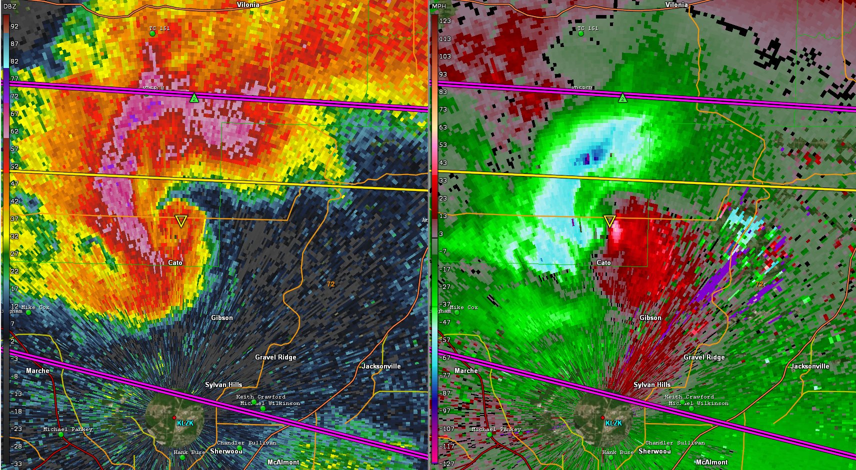 |
| A very scary radar image of a tornado north of Little Rock, Arkansas last night. |
Early March tornadoes are rare in Iowa, but twisters in mid-April are far more common there.
Some of the tornadoes in Iowa today could turn out to be quite strong, especially in western and central Iowa and perhaps extreme eastern Nebraska.
Further south, more tornadoes are possible in the Plains along a dry line, as noted yesterday. A dry line is a sharp boundary between arid air to the west and very humid air to the east.
Thunderstorms that can eventually produce tornadoes need air that cools with height to erupt. A layer of hot air in the atmosphere might act as a "cap" today in the central and southern Plains. This could prevent many wannabe thunderstorms from forming. Forecasters are unsure how many storms could break the cap. Could be many, could be almost none. So the tornado risk in the central and southern Plains could go either way.
Tomorrow, there's a greater chance of severe weather and tornadoes from the Great Lakes to the Gulf Coast.
North Dakota Blizzard
I went into this blizzard yesterday, but the forecast got even wilder. It's really unbelievable. Up to three feet of snow is expected in central North Dakota with winds gusting to 50 mph through Thursday. I can easily imagine drifts of 10 to 15 feet deep in this kind of set up. In terms of weather only, I'd say the worst place to be in the world this week will be Minot, North Dakota.
 |
| Just the beginning. North Dakota traffic cam this morning near New Leipzig, North Dakota. It will get much, much worse over the next couple of days. |
The blizzard has started and is expected to last well into Thursday. No relief from winter cold is in the forecast in that region through the weekend.
Wildfires
The outlook for wildfires in the central and southern High Plains managed to get worse, too. Forecasts have expanded the area of extremely critical fire risk. It now includes all of the Texas and Oklahoma panhandles, other parts of western Texas and a big chunk of western Kansas.
NOAA's Storm Prediction Center says there's a high probability of a "significant wildfire event" in this region. The fires will probably get overshadowed on the news by reports of tornadoes and blizzards, but this could be a terribly damaging event if these fires mow through many of those little towns scattered across the prairies.
Vermont Impacts
It looks like we'll remain in the sweet zone, if you will, protected for some reason from the biggest effects of this extreme storminess.
As expected, a batch of showers blew through the Green Mountain State overnight and this morning, with little fanfare. It looks like most of us got around quarter inch of rain, more or less.
It will actually be a nice afternoon, with sunshine and temperatures popping up into the 60s.
Tomorrow looks OK, too, though some afternoon showers might sneak into northern Vermont because a a nearby warm front. Some of those showers will continue into Wednesday night
Thursday still looks like the most interesting day of the week. The parent storm causing the tornadoes and the blizzards and the fires will swing a pretty strong cold front through here Thursday afternoon or evening.
Temperatures should get into the 60s again, but could pop up into the 70s for the first time this year if some sunshine breaks out. That's a big if. Another if is thunderstorms. If it gets warmer than expected, that could fire up some thunderstorms instead of just showers. Not severe ones, but thunder nonetheless.
Despite how wet it is out there, flooding is not really expected. Nevertheless NOAA's Weather Prediction Center has us in a marginal risk zone for excessive rain/flash flooding Thursday. That's the lowest alert level. It's possible, a few downpours could develop enough to cause some localized flooding. At this point, it doesn't look like it would be anything widespread.
Unfortunately, it does look like we're in for an extended period of chilly, dreary weather starting Saturday and continuing into next week.
No comments:
Post a Comment