 |
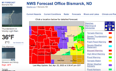
| The National Weather Service page for Bismarck, North Dakota on Saturday had every kind of weather alert imaginable from blizzard to tornado warnings. |
It seems like all the extreme weather in the world has been ganging up on this state, and in parts of Manitoba across the border in Canada.
As the Saturday screenshot from the National Weather Service office in Bismarck shows, almost every kind of bad weather imaginable was hitting the state.
This include a tornado warning, a tornado watch, severe thunderstorm warning, flood warning, flash flood warning flood advisory, winter weather advisory, blizzard warning and high wind warning.
About the only thing I'm not seeing there is hurricane warnings or tsunami warnings. The weather chaos has now evolved into a flood problem in eastern North Dakota, and the flooding might spread into blizzard-weary western parts of the state this weekend.
According to the Grand Forks Herald:
"In Greater Grand Forks, the weather service is predicting the Red River will crest at 48.5 feet mid-week. The river has already seen a quick jump - just before noon Saturday, April 23 he Red was at 28.93 feet; by early Sunday afternoon, the river was up to 39.7 feet.
The expected crest on Wednesday would be the sixth highest on record at Grand Forks, where records go back to the 1880s.
The highest Red River flood at Grand Forks, and by far the most devastating was the 54.35 foot crest on April 22, 1997.
During that flood, most of Grand Forks, including downtown was flooded. Fires broke and destroyed eleven large downtown buildings, including the building housing the Grand Forks Herald newsroom. The paper managed to keep publishing anyway.
Even if the Red River unexpectedly crests higher than forecast, it won't be as devastating as in 1997 because of $1 billion in flood control projects along the river since then.
This year's episode of flooding gets worse the further north you go. The Red River flows northward along the North Dakota/Minnesota border into Canada. Near Oslo, Minnesota. the river is expected to crest less than half a foot below the all-time record high.
Widespread flooding has also advanced into Manitoba, Canada. Weather continued to create problems for people battling the floods. Normal high temperatures in the region this time of year are in the mid-50s. Monday's highs were only in the mid-20s.
Though it will warm up somewhat during the week in the flood zone, a new, wet storm is expected to hit Friday and over the weekend.
Further west, snow and cold is the problem. Since April 12, it's only gotten above 50 once in Bismarck ,North Dakota. This in a city that normally has high temperatures of around 60 degrees this time of year.
However, flooding is a good possibility even in western North Dakota as the next storm this weekend appears more likely to cause heavy rain, and not another blizzard.
I'm sure North Dakota is lovely, in its own way, but I'm sure glad I don't live there this spring! I'd rather take the mud underfoot, the drizzly days and snow flurries we've had in Vermont for sure.


No comments:
Post a Comment