Showing posts with label stats. Show all posts

Thursday, June 12, 2025

Northern Vermont Actually Slightly Dry This Month As We Keep Complaining About Wet Weather

After getting plenty of rain in May, these peonies in
my St. Albans, Vermont gardens seemed to be 
enjoying the June sunshine this morning. 
We in Vermont have pretty much spent the entire spring and the first part of June complaining about the wet weather.  

It has been wet, of course.  The National Centers for Environmental Information says Vermont had its second wettest May on record, as one example.

But a funny thing happened as we got into June. 

Believe it or not,  northern Vermont has been a bit on the dry side so far this month, and that trend looks like it will continue for perhaps up the next six or seven days at least. Maybe more. 

Don't worry. Northern Vermont is definitely not going into drought. The ground is still pretty damp and river flows are certainly healthy. 

Plus, it's still raining in northern Vermont, just not as hard as it did in April and May. In fact, I heard a brief downpour on my roof in St. Albans in the hours before dawn today. Burlington picked up a tiny bit of rain after midnight, too. 

Through yesterday, Burlington has has 0.62 inches of rain so far this month, which is a little less than half of what would normally have fallen so far in June.  

Montpelier has only had about a half inch of rain so far in June, which is a full inch on the light side for this point in the month.  St. Johnsbury has also had less rain than average for June so far.

Southern Vermont still continues to slog through wet weather, though. Parts of southeast Vermont even suffered some flash flood damage last Friday. 

Even places near and south of Route 4 that had no flooding have been pretty wet in June. Bennington has had 2.44 inches of rain so far this month, agains an average of 1.39 inches through June 11. 

Union Village Dam in Thetford, a little north of White River Junction, has had 3.11 inches so far in June, against an average of about an inch and half. (I'm not counting the 1.75 inches of rain listed on June 1 in Thetford, as that rain actually fell on May 31. The measurement was just taken on June 1 when somebody checked the rain gauge there).

OUTLOOK

The trend toward a wetter south will continue this weekend, to an extent.

Meteorologists have backed off on how much rain Vermont will see this weekend. Still, the south looks like it will be a little wetter than the north. The bottom half of Vermont probably will get a quarter to a half inch of rain through Sunday, while the top half is scheduled to see less than a quarter inch.

All this doesn't tell us how the month will ultimately end up. Rainfall is incredibly variable in the summer, since most of it comes from hit or miss showers and thunderstorms. 

Also, things could even out so that the south might get drier and the north could get wetter. Who knows?

After this weekend, the next shot of rain come Wednesday. Early guesses are that next week's rains will focus a little more on the north than the south, but of course, we can't be sure about that yet.  

Long range forecasts going to about the end of the month slightly lean toward a somewhat wetter than average second half of June in Vermont. But as we all know, we need to take weather forecasts more than five days out or so with a Mount Mansfield-sized grain of salt. 

Tuesday, April 1, 2025

Vermont March Weather: Warm And Weird

A warm March sent daffodil shoots growing much
earlier than normal in Vermont this year. This new
spring greenery had to endure occasional wintry
setbacks, as seen here on March 21. That state
of affairs will continue into April. 
 Well, we got through another month, so it's time to look back at our overall Vermont weather in March, which, as you might have noticed was weird. And warm. 

MARCH TEMPERATURES

Burlington came in with a mean temperature for the month of 38.0 degrees. That puts us in a three way tie with 2010 and 1902 for the sixth warmest March on record. 

It's also the sixth time in a year a month in Burlington was in the top ten warmest list. 

This March was even warmer than the one a year ago, in 2024 which was merely the seventh warmest on record. Yeah, we've had a lot of hot Marches lately. A lot of hot months and years, actually, thanks to climate change. 

The entire rest of Vermont was much warmer than average in March, too. But figures are incomplete, as I noticed missing data on a few days from several of our regular long standing weather stations like Rutland and St. Johnsbury. 

The warmest March day in Burlington was 72 on the 19th and 20th.  This makes March, 2025 one of only 11 Marches in the past 140 years or so to get that warm.  It was not close to the hottest March day on record, though. It was 84 degrees in both March, 1946 and March, 1998.

Rapid snowmelt and some rain led to widespread, but minor flooding across Vermont around St. Patrick's Day. 

You could see the effects of such a mild March by the unusually early signs of spring. Crocuses were blooming by mid-month in a few locations. Green daffodil shoots poked up all through the second half of the month. The sound of returning red wing blackbirds filled the air in marshy areas way earlier in the month than usual. I even had a report of two of people in southern Vermont hearing spring peepers yesterday. That's really early for the season. 

Burlington had its final zero degree reading of the season on March 3. That meant nine days this past winter got to zero or below.  Historically we'd have roughly 20 or more such days per winter, so the downward trend in very cold days continues. 

MARCH PRECIPITATION

It was a little wetter than average virtually everywhere in Vermont in March, which is a good thing since we still have lingering effects from last autumn's drought. 

Precipitation wasn't overwhelming, though, as Burlington had 2.81 inches of rain and melted snow and ice. That's just a little over half an inch above average. By my count, Burlington had its 37th wettest March on record, so not all that impressive.

Precipitation around the state was similarly above average, but not to an extreme extent. 

Winter this March was notably absent until the end of the month. Early in the month, the summit of Mount Mansfield did have its highest snow depth since at least 2019.

But in most of Vermont aside from high elevations, very little snow fell into the end of the month. 

As we just saw, the last weekend of the month brought a big thump of five to nine inches of snow to the north, and a quite damaging ice storm to parts of central and southern Vermont.   

The snow and ice melted quickly during another very warm final day of March, though as of early yesterday, there was still 89 inches of snow near the Mount Mansfield summit. 

APRIL OUTLOOK

April is often regarded as a cruel month, as you think spring is coming, but you always end up getting slapped in the face with winter. 

That's no different this year. 

Today will be much colder than yesterday as many of us won't get out of the 30s. 

And, of course, Wednesday night, we're in for yet another round of snow, sleet and freezing rain. Though it won't be as bad as the last one, eastern Vermont in particular will likely see a glaze of ice, slick roads, and maybe an isolated power outage or two by early Thursday. 

The precipitation should change to rain on Thursday. 

Long range forecasts also call for mostly chillier than normal weather around here through at least the first half of April. We shall see. 

Even if it's a cool April, the forces of spring will win out. Normal temporaries rise rapidly. Today, the normal high temperature in Burlington is 48 degrees and the low is 30. By April 30, the normal high and low temperatures are 63 and 42 degrees.

You're going to see a much greener Vermont landscape by the end of the month compared to what it looks like now. 

Wednesday, January 1, 2025

We Did It AGAIN: 2024 Hottest Year On Record In Vermont

A thunderhead erupts in hot, humid weather in June
in St. Albans Bay. As measured in Burlington, 2024 was
easily the hottest year on record, breaking the
mark set just last year, in 2023.
Yes, Vermont had its hottest year on record in 2024. And it wasn't even close. 

On this date last year, I wrote a post about 2023 being the hottest year on record and could not believe we'd had four years in a row that were among Burlington's top 10 warmest.

Now in 2024, we've done it again, the fifth year in a row we scored in the top 10 list of warmest years. 

This year also knocked 1953 and 1898 out the Number 10 spot of warmest years in Burlington. That means all of the top 10 warmest years have happened since 1998, and nine of the top 10 have hit since 2010.  

That is simply bonkers for a period of record that goes back to the 1880s.  Climate change is really being felt in Vermont. 

Even more bonkers is the margin by which we broke 2023's mark for hottest year.  The average temperature in Burlington in 2024 was 50.9 degrees. That's 0.9 degrees - almost a full degree hotter than 2023.

That might not sound like that big a record breaker but a the hottest year on record by nearly a degree is insane if you consider we're averaging out 366 days (2024 was a leap year).

Since 2024 was the hottest year on record by such a large margin in Burlington, I'm going to go out on a limb and say you probably won't see a year as hot as the recently ended one for quite awhile, several years at least.

Then again, as I demonstrated a year ago, I can be proven wrong. We'll see. With climate change running on, though, it's inevitable we will have a year in Vermont even hotter than 2024. Unless you're quite elderly, you'll probably see a year or two or more toastier than the last one. 

It looks like St. Johnsbury also had its warmest year on record with a mean temperature of 49.1 degrees.   

That said, I have a feeling 2025 will break the streak and not become one of our top ten hottest years on record. Even with climate change, you need to have a cooler year eventually.  Today's mild weather notwithstanding, it looks like  January is going to be quite chilly, which would help drag down 2025's overall average temperature. 

After all, 2024 brought us no substantially cooler than normal months, and even many of the warmer years have at least one chilly month. Incredibly, eight months in 2024 in Burlington were among the top ten warmest. 

Burlington wasn't alone in seeing 2024 as the hottest. We'll soon have stats that show many cities in the United States just had their warmest year on record.  The United States  will probably see its hottest year on record as 2024. Plus, the world as a whole will see 2024 as its hottest year, though we won't have final numbers on that for a couple weeks .

Back here in Vermont, precipitation in 2024 was highly variable. Both in when it rained and snowed and where it rained. The summer was very wet, the autumn very dry. 

At Burlington, rainfall for the year was unremarkable. Total rainfall for the year there was 38.35 inches, which is just 0.82 inches above average

St. Johnsbury set a new record for rainiest year with 55.59 inches. That included an incredible 17.15 inches that fell just in the month of July.   Southern Vermont saw slightly below normal rainfall for the year. 

It was certainly an eventful year in Vermont, as we had several devastating floods, along with damaging wind storms, winter storms and oppressive heat. With climate change, extreme weather is becoming the norm in Vermont and many other places.

Expect plenty more weather weirdness in 2025. 

DECEMBER

December in Vermont broke the trend of warm months in 2024.  Most places saw temperatures near or just slightly below what is regarded as normal.  Remember, this is the "new normal," which is the average of temperatures between 1990 and 2020.

 Due to climate change those years were warmer than the 20th century average.  Had December, 2024's weather hit a half century ago, it would have been regarded as a little on the warm side. 

The biggest news of the month was when Burlington's temperature fell to minus 3 on December 22. That ended a record long 663 consecutive days above zero. 

A record or near record warm spell in the closing days of the month offset generally chillier than average conditions on several days either side of the Christmas holiday. 

Precipitation across Vermont was a little above average, which was good news after a remarkably dry autumn. Most of the precipitation fell on and around December 11, when 1.5 to as much as three inches of rain drenched the state.

Such a storm would have normally created some flooding, but it was so dry prior to the storm that there was little trouble with rainfall. 


Thursday, July 11, 2024

Thursday Evening Vermont Flood Update: One, Possibly Two Deaths, Massive Rain, Massive Destruction, Oppressive Weather Outlook

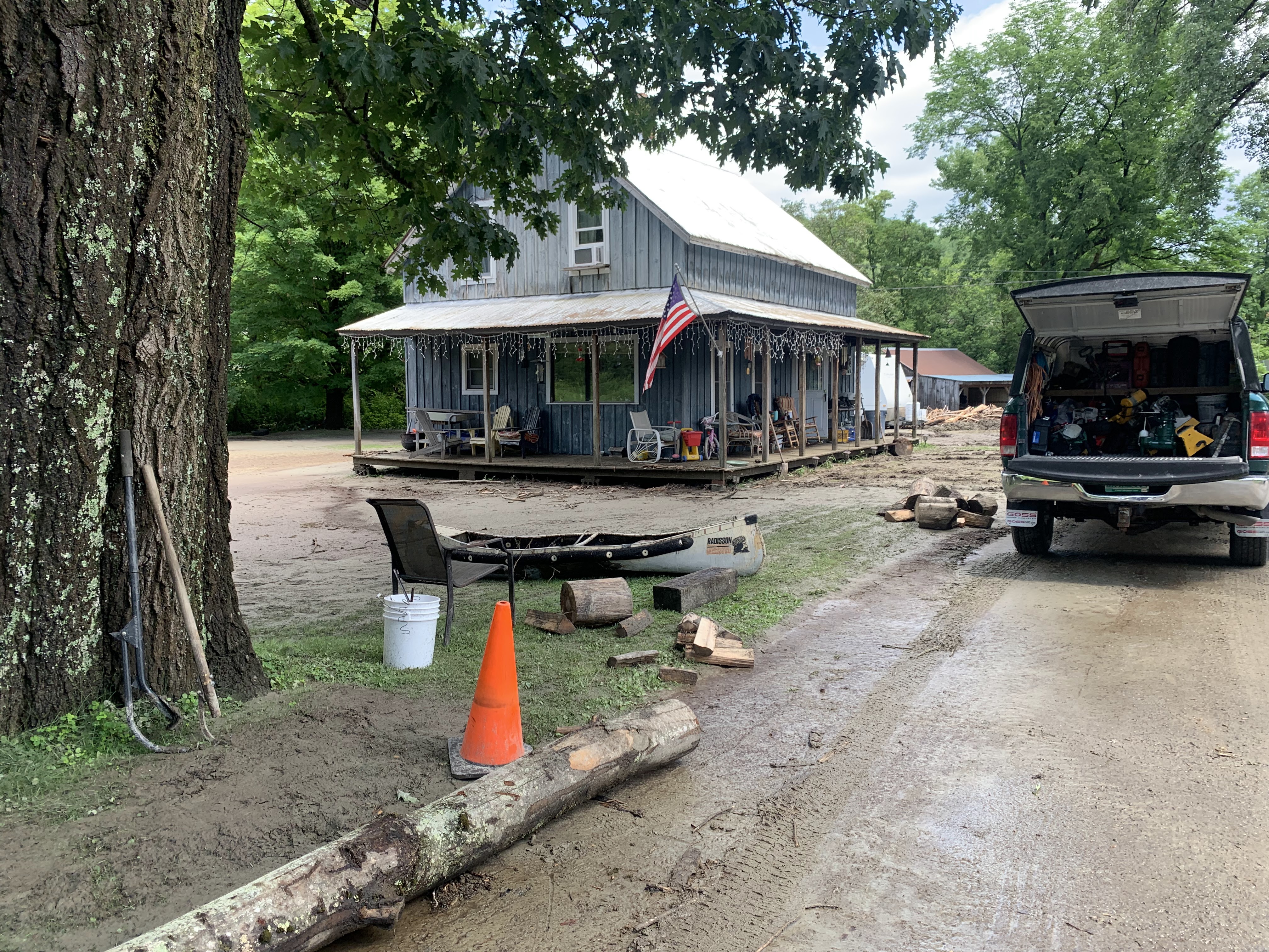
Dishearteningly digging out.

A washed out driveway this morning in Richmond, Vermont.
That's what Vermonters started up again as flooding began to recede in most - but not all - parts of the state. 

The lower sections of the Winooski River, the Lamoille River from Johnson on west to Lake Champlain and the Passumpsic River in the Northeast Kingdom were continuing to cause new and/or worsening problems as of late this afternoon. 

The Latest Stats

The death toll is at least one, and possibly two. State Public safety officials said a man was swept away last night in Peacham. 

The stats are sadly impressive. At least 54 state roads and 6 bridges were closed this morning. That doesn't include the likely hundreds of town roads closed or partly shut down by flooding and washouts. 

Rainfall totals were incredible to say the least, especially since all of it came down in fewer than 24 hours, with the vast majority coming in 12 hours or less

Walden reported 7.25 inches. The Mechanicsville section of Hinesburg saw 6.91 inches. St. Johnsbury and Monkton reported 6.4 inches. 

Numerous towns had between four and six inches of rainfall. 

It's clear the damage doesn't cover as much of the state as the flooding on July 10, 2023. Some towns in Windsor County had a quarter inch of rain or less.  But in many areas, the flooding and damage are even more intense than what we saw last year. 

That's because in some of the hardest hit areas, rainfall was heavier and happened over a shorter period of time than during the flooding last year. 

Jay Shafer posting on X, formerly Twitter, had examples. Duxbury saw 5.85 inches of rain this time and 4.40 inches in last year's event. In this storm, one weather station in Hinesburg reported 5.82 inches, while the same rain gauge last year piled up just 2.82 inches. 

Other places in the flood zone had less rain this time than a year ago. Middlesex got an impressive 4.5 inches this time, but 7.21 inches last year.  

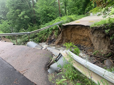
A small tractor along a collapsed section of road
near Hinesburg, Vermont Thursday. 

I guess that's why the damage pattern was so variable. 

Some towns were notably hard hit and will unfortunately become the iconic symbols of Vermont's latest weather/climate disaster.

 Plainfield

There were also close misses: Rescuers broke a window in one inundated building, and pulled a woman out of the window. Moments later, the part of the building the woman had been in was swept away, Vermont Public reported. 

Vermont Public also had more information on that apartment building in Plainfield. It was known locally as the Heartbreak Hotel, and now that more than half the building is gone, that name seems more apt than ever.

VTDigger reports that seven bridges in Plainfield were swept away, along with some crucial culverts. Structures are gone, too, in addition to the Heartbreak Hotel. Two dozen people were evacuated, and the town's water service is gone, at least for now. 

Lyndon

The parts of Routes 122 and 5 in Lyndon regularly flood when the Passumpsic River gets high. But residents said they've never seen anything like this. 

This is where the possible second flood death might have happened. As WPTZ reports, a man in a pickup truck drove around a barrier on a closed and flooded road, apparently believing he could make it through.

A house in Bolton, Vermont surrounded by mud and
debris after the floodwater receded Thursday. 
The town's police chief said bystanders tried to wave the man down to stop him, but the belief is the driver thought the people waving at him might have been just trying to be friendly.

The man's truck has since been found downstream, but the man was still missing as of late Thursday afternoon. 

Meanwhile, about 50 people were rescued from flooded homes in and around Lyndon and Lyndonville Thursday. 

Drone footage showed several homes and businesses along Route 5, including the iconic Miss Lyndonville Diner, inundated. 

Weather Outlook:

As expected, some showers have been lingering around Vermont today. I noticed late this afternoon, the remains of Beryl were still keeping northern New York cloudy. Meanwhile partial sunshine broke out in most of Vermont.

That created a kind of weather front across northwestern Vermont, caused by the difference between the relatively cooler temperatures under the clouds and the hotter readings in the sunshine.

As of 5 p.m. that "front" if you will created a broken line of showers, a couple with brief downpours in northwestern and north central Vermont. 

So far, there hasn't been nearly enough rain with these to renew problems, but I'm watching. At the very least, these showers will probably briefly hinder recovery efforts.

What will really get in the way of the cleanup is the warmth and humidity the next few days. The  dew point, a rough measure of how humid it feels out there, should stay stubbornly between the mid 60s and low 70s daily through at least Monday. That's considered pretty oppressive. '

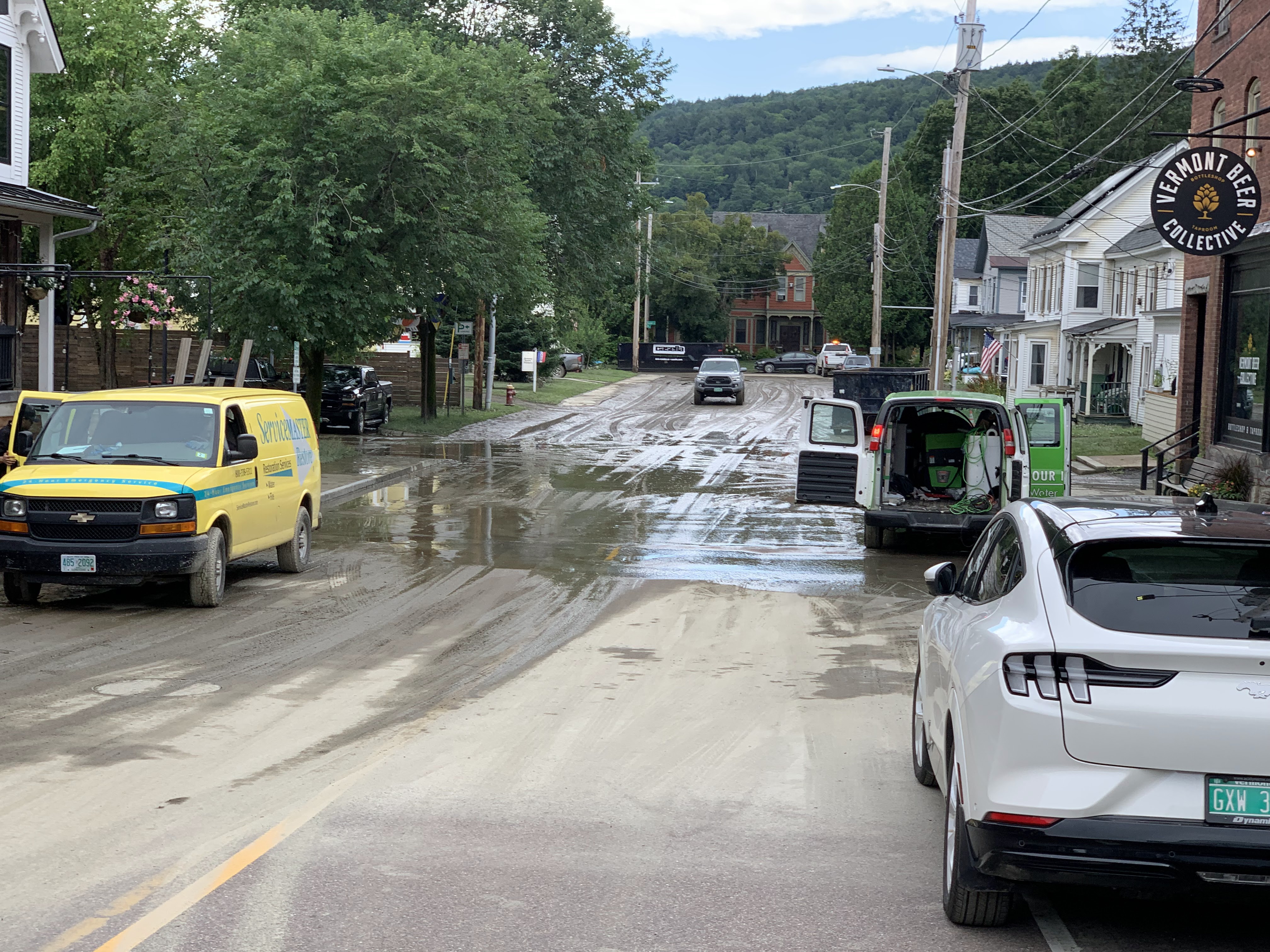
For the third time in a year, mud and flood restoration
service trucks on Elm Street in Waterbury Thursday. 
Friday will be the "coolest" day if you can call it that, with highs ranging from 77 to 84. Then, Saturday through 

Daytime highs will Saturday through at least Tuesday will get well into the 80s to possibly near 90 in the warm spots. 

There's yet another bullet in the weather chamber in the next couple of days, but we here in Vermont look like we'll dodge it. 

The Bermuda High off the East Coast is really strong and getting stronger. In fact, we should be glad it's not closer, as it's so strong it would cause record high temperatures in our neck of the woods. 

Instead, it's well offshore, and expanding. That has stalled a weather front along the Mid-Atlantic Coast and is gradually pushing it northwestward. That will cause potentially torrential downpours and flooding from the Carolinas to southeastern New England. 

It doesn't look like that rain will push northwestward enough over the next few days to cause real problems in Vermont. Far southern parts of the state might see a few downpours from this system. But they escaped this week's flooding and can handle it. 

We'll have to watch for thunderstorms early next week. It's hard to say whether they'll be enough to cause new problems. Early guesses are they won't be too dangerous, but we'll keep an eye on 'em. 

If you want some glimmers of hope, here's this: We could have at least a brief break in the heat toward next Thursday. 

I know long range forecasts are not always reliable, but those long range forecasts have backed off quite a bit on what had been quite a lot of expected hot weather around the third week of the month.  More importantly, the forecast for that time period between roughly July 15 and 25 has trended toward somewhat below normal rainfall.

We can only hope. 


Thursday, March 28, 2024

Springtime Means Snow Melts Fast In Vermont

 Well, that was quick.

My St. Albans, Vermont yard, late afternoon this
past Monday........
For most areas of Vermont, all that snow we saw this past Saturday is done already. Or at least greatly diminished.  

Here in St. Albans, which only saw six inches of snow Saturday, it was completely gone by early Wednesday afternoon. 

You can find a lingering snowbank here and there where plows shoved the accumulation into piles, but that's it.

Most other places in Vermont had just patches of snow left.  In general, four to 12 inches of snow remained Wednesday in places hardest hit by Saturday's storm. High elevations, where it's colder, are hanging on to more snow. 

I'm impressed by how much the snow compacted and partly melted in spots where the snow was deepest. Both West Windsor and Shrewsbury received more than 30 inches of snow Saturday, but in both towns, the snow depth on the ground Wednesday was just 12 inches, according to data from the National Weather Service in South Burlington. 

The high sun angle of March really helped to erode the snow, too.  Bright sunshine Sunday and Monday really chewed up the snow.  Some of it evaporated into the dry air instead of running off because the humidity was so low.

Some weather stations in Vermont calculated the water equivalent of the snow remaining on the ground. Due to a lack of heavy rains the meltdown has been orderly, with no flooding 

......same exact view less than 48 hours later. That snow
disappeared FAST! 
West Rutland had something like 20 inches of snow Saturday. If you melted it down that day, you'd have something like a little  under two inches of rain. By Wednesday, the remaining snow on the ground there contained just 0.9 inches of water. 

Vermont is having a close miss today that could have led to flooding had the weather pattern shifted just a bit. 

Another in a series of soggy storms is making its way through eastern New England today. 

A flood watch is up today for Rhode Island, the eastern  half of Massachusetts, the southeastern half of New Hampshire and most of Maine due to this heavy rain.

Some of that rain is venturing into mostly southeastern Vermont today, but it won't be heavy enough to cause any real issues there.

Just because the snow is gone, or rapidly disappearing in Vermont right now doesn't mean we're completely done with it. 

Some sort of possibly substantial storm seems like it wants to arrive this coming Tuesday or Wednesday. It's way too soon if that one will be mostly rain, or whether some of us see accumulating snow. 

We'll know more by Sunday.  Just note in all my years in Vermont, I can't recall any April where didn't snow in Vermont. In a few Aprils, like in 1974, 1975, 1983, 2000, even many low elevations had more than a foot of snow. 

Sunday, August 21, 2022

A Welcome Hurricane Drought, But How Long Will It Last?

Hurricanes and tropical storms lined up in the 
Atlantic Ocean, September, 2018. It's been a 
slow hurricane season so far, but by next month,
we could well be seeing satellite images
very much like this one. 
 Unlike in recent years, we in the United States and people in the Caribbean have gotten most of the way through this August without a destructive hurricane. 

Which is a very great thing, considering all the other extreme disasters that have befallen parts of the United States and the rest of the world this summer. We've had quite enough trouble with extreme flash floods, drought, wildfires and the like, thank you. 

All the forecasts leading up to hurricane season said we'd have another very busy year in the tropics. And we still might. Right around August 20 is when things normally start to really heat up, as we head toward the peak of hurricane season, which is around September 10 or so.  Big time, bad hurricanes can happen anytime between now and roughly the middle of November.

So far, though, it's been quiet. We had three relatively small tropical storms earlier this year. The biggest, Bonnie, became a hurricane after it completed a rare feat of crossing Central America and winding back up over the Pacific Ocean.

More recently, what would have been Tropical Storm Danielle fizzled yesterday as it failed to get its act together and splashed ashore as disorganized batch of thunderstorms in northeastern Mexico.  The National Hurricane Center is watching another disturbance off the west coast of Africa. It'll take awhile for that one to develop into anything, if it does at all. 

So far, we have gone 320 days without a hurricane in the Atlantic Ocean. That puts us in the top ten list of longest periods of time with no hurricanes.

This is quite a change from recent Augusts.  In August, 2017 Hurricane Harvey unleashed an unprecedented flood in Houston and other large swaths of Texas. 

August, 2020 was part of the busiest Atlantic hurricane season on record, and brought Hurricane Isaias to the East Coast and super-destructive Hurricane Laura to Louisiana.  Last August, Hurricane Ida, as strong as Laura the year before, hit Louisiana, and later unleashed deadly flash floods in and near New York City. 

The 2022 hurricane season up to this point is actually not all that much quieter than normal. By now, we've usually had about four tropical storms or hurricanes. We've had three. Early season storms, the ones that come before about now, are more often than not relatively weak. Almost all major hurricanes have occurred after August 20.

The season has been relatively quiet so far because a lot of dust has been blowing off the Sahara Desert and out into theAtlantic Ocean. That dust tends to squelch hurricanes. It also looks like the Bermuda High, that traditional heat pump, has often been further north than  normal.  

That has allowed that Bermuda High to pull some of the hot, dry air that has been torturing Europe all summer out into the Atlantic Ocean. The dry air can inhibit tropical storms. 

Slow starts to season like this one can easily flip to busy ones, and that's still the prediction for this year. We can look to 1999 as an example. There was pretty much nothing until August 18, then 11 tropical storms, including eight hurricanes formed in the next three months after mid-August. 

One of those 1999 storms, Hurricane Floyd, unleashed a horrible flood in the Carolinas, and here, in Vermont, caused one death, along with some wind and flood damage.   

Yes, we can hope the rest of the 2022 hurricane season is slow, and hope that those predictions for a busy year were just a hot mess. Or if it does get busy, we can pray all the storms curve harmlessly out to sea.

But I wouldn't count on any of that. A lot can happen with hurricanes, especially in the peak season from now into October.  

Monday, August 1, 2022

July In Vermont: In "New Normal" Era, We Were Close To Average. But It Was Hot

Flowers in my St. Albans, Vermont gardens enjoy 
some humid late evening sunshine on a July evening
If you take into account the "new normal" we are under with climate change, the July that just ended could not have been more "average." 

In Burlington, the mean temperature was 73.3 degrees, just 0.9 degrees above what is now considered normal. 

 The National Weather Service updates what is "normal" once per decade. They take the average every year for the past 30 years and call that normal.

This year, each month is compared to all the months from 1990 to 2020.  Since those three decades were warmer than previous ones, the "normal" is warmer, too. 

For some context, even though Burlington was less than a degree above this normal, we still just barely missed out on scoring in the top ten list of hottest Julys. Number 10 had an average temperature of 73.5 degrees.

Also, had this July occurred around 1980 instead of 2022, it would have been considered 3.7 degrees hotter than average.  

In the rest of Vermont, as in Burlington, this July wasn't too far off the new normal in most places. Montpelier's records show this July was 2.4 degrees hotter than average there. St. Johnsbury said July, 2022 was only 0.4 degrees on the warm side. Bennington was 1.6 degrees above average in July.

Rainfall in July was near to somewhat below normal, depending upon where you were in the Green Mountain State.

Burlington logged 4.04 inches of rain, which is right at average. Technically 0.02 inches on the light side, but really, spot on. If the month seemed dry, it was because a lot of the rain fell in very short bursts. 

An odd cloud structure over Interstate 89 in Georgia, 
Vermont on July 23. The second half of the month
featured several rounds of storms, some severe
in the state. 

Half of Burlington's rainfall for the month fell in less than five hours, contained in brief but intense downpours on July 19 and 28.  

Rainfall in St. Johnsbury and Rutland was also pretty close to average. Other towns missed out on some of the downpours. Montpelier had 3.4 inches of rain in July, nearly an inch on the light side. Bennington was more than an inch and a half short on rain, with just three inches for the month against a normal of 4.65 inches.

The character of July weather in Vermont had two phases. The first half of the month was on the cool side, continuing the trend from June in which Vermont was pleasantly comfortable while most of the rest of the nation simmered in torrid conditions. 

The second half of the month turned decidedly hotter, though the full force of the heat waves still managed to avoid us. Burlington did endure six consecutive days in the 90s from the 19th to the 24th, ,and that was one of the city's longest heat waves on record.

Still, everyone in Vermont maxed out in the low 90s in July, which falls well short of the kind of all time record highs large swaths of the northern hemisphere have seen this summer. 

The hotter, more humid weather in the second half of the month created conditions favorable for severe storms. 

The oddball weather event of the month came on July 18 when a seemingly innocuous shower with no lightning got some real spin to it, and dropped two separate tornadoes on Addison County. Both were captured on film. 

The first twister, in Addison County, was an EF-1 with top winds of 90 mph. It damaged a carport, the deck on a home and numerous trees. The second, a weak brief EF-0 with top winds of 70 mph touched down in Waltham and caused little damage.

The Northeast Kingdom seemed to be ground zero for Vermont severe weather in July, with several days of damage reports. The worst of it came on July 21 when a rotating storm that carried a tornado warning swept through.

No tornado touched down, but high winds damaged lots of trees and power lines. Hail that in some cases was a little bigger than golf balls dinged cars and roofs. 

As we move into August,  it looks like the first half of the month will mostly have the same weather pattern we had in the second half of July. That means that intense heat lurking well to our west will send brief squirts of hot air our way. But before it gets too hot, weak cold fronts will usher the worst of it away.

If that comes to pass, we will have a warm, but not record hot early August. As always, there's no telling what the second half of the month will bring. But by then, we will be headed toward fall, and chances are you'll see a cooling trend as fair season arrives.


Wednesday, April 20, 2022

Spring Is Resuming Today, But Why We Got That Huge Storm And What Are Its After Effects?

Trees on the verge of collapse during yesterday's wet
snowstorm in St. Albans, Vermont
 For the second year in a row, much of Vermont received a surprisingly strong winter storm in the third week in April. 

In both cases, the snowstorms hit during a spring that was earlier than usual, though 2021's version featured a much earlier spring than this year. 

April Winter Storm 2022 surprised forecasters as snowfall was much heavier than predicted. This storm had a high bust potential to begin with. 

Temperatures were just a degree or two colder than forecast, and the atmosphere was only subtly more primed for heavy snow than predictions ahead of the storm.

Meteorologists with the National Weather Service in South Burlington, and local TV meteorologists got the basic premise of what would happen correctly well ahead of the storm. 

They knew that overnight Tuesday and into Wednesday, a pretty hard thump of snow would move south to north across Vermont. And that's what happened. However, expectations were that valleys would be warm enough so that there would only be an inch or so of snow before things changed to rain. Mid and high elevations would get three to six inches of snow, which is what happened. 

However, the cold air hung on long enough so that during the period of heaviest precipitation, the snow never changed to rain, at least in western Vermont. So that inch of snow turned into three to six inches, with locally higher amounts. 

I also think the precipitation was a little heavier than forecast. That rush of  heavy snow coming down from aloft might have helped cool the air near the ground just a bit, so the snowflakes managed to land without turning to rain first.  

As expected, eastern Vermont had less wintry weather than the western half of the state, as the storm took an inland track northward through central New England. While areas west of the Green Mountains were stuck in the 30s early Tuesday afternoon, it go up to a seasonable 55 degrees in St. Johnsbury.

Meteorologists had said before the storm that central New York and the Adirondacks would have the heaviest snow of this storm and boy did those areas deliver! 

Damage from heavy, wet snow in St. Albans Tuesday.

Amounts were as high as 18 inches in the towns of Bleecker and Virgil, New York. 

THE STATS

Believe it or not, at least in Burlington, this wasn't even a record high snowfall for the date. The National Weather Service in South Burlington measured 4.2 inches of snow Tuesday. But on the same date in 1925 there was a six inch dump. 

However, I only found two days in the roughly 140 years of records in Burlington with more snow later in the season than yesterday.  There was 4.3 inches of snow on April 20, 1953 and 4.9 inches on April 23, 1993. 

Of course, other parts of Vermont have had frequent bouts with even deeper snow into the month of May. 

Gusty winds mixed with the wet snow in some areas contributed to the power outages, which peaked at around 22,000 in Vermont yesterday. As of 6:30 this morning, about 2,100 customers were still without electricity. 

Gusts as high as 54 mph were reported in Proctor. Much of the Northeast Kingdom had strong gusty winds as well.This led to a tragedy on Lake Seymour in Morgan when two young men died when their canoe overturned.  According to VTDigger, the two set out on the lake in the canoe when strong winds arose, causing waves and areas of slush that overturned the boat.  The two tried to swim to shore, but drowned. 

There was a lot of water in Tuesday's snow. Melted precipitation was 1.11 inches in Burlington, which was a record for the date. This puts the month of April solidly wetter than normal, but not remotely near any records.  Most other areas in western and central Vermont also had about an inch of precipitation yesterday. 

YOUR GARDEN

This Korean lilac in my St. Albans, Vermont yard looked
completely smushed to the ground and potentially
ruined by heavy wet snow, but as the snow melted
the branches bounced back into place and this
lovely shrub was completely unharmed by the snow.
Damage to early season gardens will not be as bad as during another bout with snow and cold a year ago, on April 21-22, 2021.

The only real damage this time around will be if the heavy snow broke branches on any of your trees or shrubs.  I do have minor damage in my gardens from snapped and bent branches, but nothing extensive.

The good news is your early hardy perennials and tree buds are fine. Temperatures during the storm bottomed out at around 32 or 33 degrees, which is not cold enough to harm anything. 

Last year, buds and flowers were more advanced than this year, so lilac, crabapple and other flowering trees and shrubs suffered some damage last April as temperatures crashed well into the 20s just as these plants were starting to bloom.

FORECAST

A little more snow fell overnight in the mountains, judging from radar reports and web cams that show snow covered roads at high elevations. Snow showers lingered in the mountains all night, so I bet there was several inches of snow at summit level, but little if anything below 1,500 feet.

Jay Peak reported an additional six inches of snow overnight for a storm total of 15 inches. 

Runoff from the snow melt will probably put the Lake Champlain lake level at just under its flood stage of 100 feet above sea level.  It will be mushy underfoot for a few days once again.  

Strong south winds Thursday might cause some minor splash over and erosion problems along some shorelines in the northern half of Lake Champlain. 

To help dry things out, we are expecting very little rain in the next week or so. It'll amount to just a few hundredths of an inch to a quarter inch now through next Monday which is next to nothing. 

Though things will get decidedly more springlike than yesterday, we've fallen into a pattern that will keep us mostly cooler than normal at least into early May. Not every day will be on the cool side, but that will be the trend. Too bad, I like warm spring days. 

In the near term, today will be blustery and quite cool, even with increasing afternoon sun. Highs will only make it into the upper 40s, which is about 10 degrees on the cold side. Still, the remaining snow on the ground should disappear for most of us, unless you're up high. 

It stays cool through the weekend, with some frosty nights (not damaging for what's out there now). Afternoon temperatures through Thursday through Sunday will be in the 50s. We might get one day of warm weather Monday before it turns chilly again. 

I don't see any signs of more snowstorms in the coming days. At least not here. We're not in North Dakota, parts of which are expecting their third big snowstorm in a little over a week. Ugh!

Sunday, January 30, 2022

Blizzard Over, But Much Of Nation, Including Vermont, Faces New Wide-Ranging Winter Storm

Some damage to trees from freezing rain in Alburgh,
Vermont in January, 2020.  The Green Mountain State
is at risk for a winter storm toward Thursday that could
drop a bunch of snow, rain, ice or all of the above. 
The remarkable well-forecasted Blizzard of '22 has wrapped up in New England, and we're just left with another frigid, below zero morning. 

The snow of course missed Vermont, but the icy air sure didn't. This was the 15th morning that Burlington, Vermont has gotten to zero or below this month. 

 That's the most in a single month since 17 such days happened in February, 2015. The most zero or subzero days in one month was 23 in January, 1970, says the National Weather Service in South Burlington.

Coming up, we have a warmup and a potentially messy, snarly possibility of a winter storm. More on that in a bit. 

First some final blizzard stats: 

The most snow I've seen reported from the storm so far is 30.9 inches in Stoughton, Massachusetts, followed closely by 30.4 in Sharon, Mass. and 30 inches in Quincy.  Many reports of more than two feet of snow came in from Massachusetts, especially in the South Shore area.

Boston picked up 23.8 inches of snow, their seventh largest snowstorm on record. It was also Boston's snowiest single January day on record as well.

The storm did verify as an official blizzard in parts of Delaware, New Jersey, Long Island, New York, eastern Connecticut, Rhode Island, Massachusetts, New Hampshire and Massachusetts. 

The last of the blizzard warnings in the United States expired in Downeast Maine earlier this morning.  As of 6 a.m., it has already stopped snowing in that neck of the woods.  The most reported snow in Maine was 18 inches at Brunswick. 

Some wags called this New England storm a "blizzicane" considering the several hours of sometimes hurricane force gusts along the coast. Barnstable, Massachusetts reported a gust to 83 mph and there quite a few gusts of 70 mph or more along the New England coast. 

Now that the Blizzard of '22 is over in New England, attention is turning to a new winter storm. 

NEW STORM

The National Weather Service is already gearing up to warn people of yet another nasty winter storm that will affect a broad area from Texas to New England during the middle of the week. This one will cover much more real estate than our dearly departed Blizzard of '22 did.

Worse, it will contain a wide variety of weather, including heavy snow, a bunch of freezing rain, possible flooding, a chance at severe thunderstorms, high winds and bitter cold, depending upon where you are. 

This won't be a powerful, deep concentrated storm like the one New England just had.  Instead, the next winter storm will be the child of a strong, warm ridge of high pressure off the East Coast, a feed of rich moisture from the Gulf of Mexico, and a sharp Arctic blast heading southward through the middle of the nation. 

By Wednesday, a slow moving cold front will extend from somewhere in or near northern New England to Texas. One or more storms will ride northeastward along this front, making full use of the deep Gulf of Mexico moisture. 

This far out, the devil is in the details as to who gets what and how bad. But this is a classic setup for a damaging ice storm somewhere.  At this point, that seems most likely in a band from northeast Texas, through Arkansas to southern Illinois, but that picture could shift north or south. 

Northwest of that ice would be a heavy snowstorm. People southeast of the ice zone could see some flooding. 

Also, as the storm eventually works its way into the Northeast, rain and thawing atop all that blizzard snow could also result in a flood.

Meanwhile, Texas can expect an Arctic cold snap that might not be as destructive as the disaster last February, but will still be a hard test for the state's rickety electrical infrastructure.

VERMONT IMPACTS

It's unclear what this new storm will do to the Green Mountain State, but it will probably be a lot more than the blizzard that missed us Saturday.

Depending on where the stalled front sets up, we could see anything from a heavy snowstorm, to another round of ugly freezing rain, or just warm, plain rain that could cause localized flooding especially if the rain breaks up ice in the rivers.

From this vantage point, the best chance of a snowstorm is north of Route 2 and the best chance of a warm rain is south of Route 4 on Thursday. Some places in Vermont could get a bunch of freezing rain, which isn't good. 

That's just a wild stab in the dark at this point. Vermont is going to be very close to some super warm air just to the south and some Arctic air just to the north. With that set up, it's impossible to tell at this point where in Vermont the cold air might invade, or where the warmth might filter in. 

We'll just have to update as we go along. Expect benign weather with a welcome warming trend through Wednesday. Then, all bets are off. 

Wednesday, August 25, 2021

Yes, Vermont Has Had A Humid, Icky Summer. Especially Nights

Flowers in my St. Albans, Vermont garden on a humid
morning this past July. It's been a VERY humid
summer in Vermont. 
If you think this summer in Vermont has been more humid Florida than refreshing cool Green Mountain State,  you're right.  

The normal spells of cool, dry air have been hard to come by this summer and August has been particularly terrible in that regard. 

One way to judge the humidity of a particular summer is to look at whether there's been a lot of warm nights. The temperatures stays up on muggy nights  compared to evenings when the humidity is low.

 If you get a night in Vermont that stays at 70 or above, it's stuffy, no matter how you look at it. 

To prove my point that this summer has been a humid one around here, the following paragraphs might have more than a few numbers. But it's pretty illustrative. 

So far this year, there have been 18 days in Burlington, Vermont that failed to get under 70 degrees for an overnight low. 

I haven't been able to check all years, but the number of days that failed to get below 70 in Burlington  seems iclose to a record.  Last year is considered the hottest summer on record in Burlington, but there were only 10 days that never got below 70 degrees. 

The year 1949, which had the most 90s on record, had only 14 days that stayed above 70.   This year so far we've had twelve 90 degree days, definitely well above normal but not close to the record of 26 such days. 

The year 2018  is so far barely beating out this year for stuffy nights .  There was 19 days at or above 70 that year. The year 2018 was the third hottest summer on record. It looks like this summer will come in fourth of fifth on that list.  

The bouts of stuffy nights this summer have been long lasting, We had four consecutive nights in late June in which that temperature stayed at or above 70 degrees.

July was regarded as relatively "cool" but that's because we had so many clouds that daytime temperatures were suppressed. We still had two 70 degree nights in July and many overnight "lows" that month were in the mid and upper 60s.    

Burlington had five consecutive days that stayed at or above 70 degrees from August 9-13, the longest stretch since 1901. We just endured a full week in which the low temperature was 69 or higher, with five of those seven nights staying at or above 70 degrees.

The more consecutive nights in which it is uncomfortable for sleeping, the more dangerous it gets. Many houses in Vermont have no air conditioning.  The longer a period of icky humid weather lasts, the more it can wear a person down.  That gets risky for people with underlying health conditions.  That's why we're always told to get people into cool spots like air conditioned rooms to give them and their bodies a break.

This morning in Burlington spelled slight "relief" as it was 66 degrees for  a low. But we have more Florida like weather to endure the next two days or so. 

All this mugginess and these uncomfortable nights in Vermont are consistent with climate change.  The world is getting hotter, so you it stands to reason that it would get hotter. Hotter air in general can hold more moisture, so it stands to reason that we'd get more humid weather, especially if the air flow is off the tropical Atlantic or Gulf of Mexico, which is frequent in the summer.

In the short term, relief is on the way. It's the end of August, so cold fronts are starting to have a little more oomph than they did midsummer.

A cold front is coming through Thursday night, and you are going to LOVE Friday.  The sun will be out, daytime temperatures will be only in the low 70s. More importantly, dew points will be in the 50s.  Dew points temperatures are a good measure of how uncomfortable it is out there.  

If the dew point is near 70, which it has been most of the time in the past week. If dew points are in the 50s, it's very comfortable.

We stand the risk of having more bouts of humidity as we go into September, but those periods will get shorter and shorter and weaker and weaker as we head into autumn.  It looks like it might get quite sticky again early next week, but that spell shouldn't last nearly as long as the one we are enduring now. 


Thursday, November 12, 2020

Vermont's Biggest November Heat Wave Finally Ends

After a week of record warm November temperatures, I'm 
still finding flowers in my St. Albans, Vermont gardens. 
 It was a humid evening, and I was working in my gardens.  Because of the warmth, I wore just a flimsy t-shirt and shorts. I still worked up quite a sweat. I was actually relieved when some light sprinkles started.  The rain drops gave me some needed cooling. 

This happened last evening. In northern Vermont. In November. Clearly a bizarre situation for this time of year. 

It is back to reality today, as temperatures will stay in the 40s to near 50.  Pretty close to average for mid-November. 

The last few days were clearly anything but.  As the warm spell got under way last week, I speculated that it could be the biggest November heat wave in the Vermont weather record books. 

I hereby declare it as such.

True, we never got to the hottest November reading on record for Burlington or the entire state. The highest it's been in Burlington is 75 degrees. In this warm spell, the city "only" made it as high as 72 degrees.

What the warm spell lacked in absolute high temperatures more than made up for in duration.  Montpelier had four record high days in a row.  Burlington had seven consecutive days at 67 degrees or higher. There had never been more than two consecutive days of 70 degree readings on record in Burlington. Until now. There were four such days. 

Some areas near us DID see all time records for November. Montreal had its hottest November day on record with a high of 73 degrees. The province of New Brunswick had a preliminary report of 77 degrees, which would make that New Brunswick's warmest November day.  

Here are some other wild stats about this warm spell, courtesy of the National Weather Service office in South Burlington. These records go back as far as the 1880s:

The average high temperature in Burlington for the past week was 70 degrees.  That would have been about average for mid-September. 

This past week, averaging the high and low temperatures, we end up with 59.4 degrees, easily the warmest week on record for any time in November. The previous record was 55.2 degrees in 1938.

The average daily low temperature for the week was exactly the same as what the normal high temperatures for the week should have been - 48.2 degrees.

Yesterday's low temperature of 60 degrees was the warmest on record for any date in November. 

 Another strange aspect of the warm spell was the sunshine. True, yesterday was cloudy, especially west of the Green Mountains. But we had a week of nearly wall to wall sunshine in Vermont. This time of year, we rarely get more than one sunny November day lost amid a sea of overcast days. Not this year. 

I don't see any signs of renewed warmth in our immediate future. In fact, Tuesday and Wednesday of next week look briefly wintry.  Then things will probably warm up to something near normal for November. Not great, but not as dreadful as it can be this time of year. 

Remember, though. This was a remarkable string of oddly pleasant weather.  No good weather in Vermont goes unpunished. We'll pay for this somehow this winter.  The gods will see to that.