 |
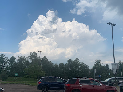
| Severe thunderstorm looking south from Hinesburg, Vermont. Not sure but looks a little like a wall cloud structure in there. This storm was not tornadic, though. |
This was an atmosphere that was really primed for storms. It was fascinating to watch just little triggers ignite a fuse to create storms in minutes.
Video of some of the stormy weather is at the bottom of this post.
The first wave began on schedule in the late morning over the Adirondacks as a cluster of storms that congealed into something that looked like a supercell that went across the northern Champlain Valley and on into the Northeast Kingdom.
By the time the storm got to the NEK, it had prompted a tornado warning, though no tornado is known to have touched down. The storm did pelt some NEK towns with hail, some of which was a little bigger than golf balls. Strong winds caused damage as well.
In areas that did not get directly hit by that storm, updrafts in the atmosphere caused storms to erupt instantaneously, going from just a towering cumulus cloud to something strong enough to prompt severe storm warnings in minutes.
Also as expected a final line of storms erupted just ahead of a cold front of sorts late in the afternoon.
Again, the trigger seemed to be right on the New York/Vermont border. Many areas from Burlington south had not had a thunderstorm by 3 p.m., so the hot, humid air was still highly unstable.
I watched a small cluster of benign showers over eastern New York become a powerful but broken line of storms that extended from near the Canadian border all the way to southern Vermont. The time it took for the storms to just begin producing rain to getting to the point they were strong enough to prompt storm warnings was as little as 15 minutes.
 |
| Storm just starting to form looking north from Milton, Vermont at 2:04 p.m. Thursday. |
I was impressed.
Aside from the effects of large hail, we were lucky that pretty much the only damage in Vermont was lots of fallen trees and power lines. At its peak, just under 7,000 homes and businesses were without power in the Green Mountain State because of the storms.
Power has since been restored to just about everybody.
I'm also glad the storms were moving right along. We had incredible amounts of moisture to work with so the downpours were beyond torrential. I saw instances of very flash flooding in Georgia and Colchester, even from downpours that lasted less than 15 minutes.
HEAT GOES ON
The heat before the storms allowed Burlington to log its first official heat wave of 2022. (A heat wave is defined as three consecutive days of temperatures of 90 or over). Since Sunday, four out of five days reached at least 90 in Burlington. Monday was the exception under clouds and showers.
Burlington has a shot at seeing more 90 degree weather. That cold front, as it were, wasn't exactly cold. The air behind it, the conditions were are in now, are less humid for the moment, but not much cooler than they were.
It'll get well into the 80s, possibly near 90 today with mostly sunny skies. Same for Saturday, except there might be a few extra clouds due to rising humidity. Isolated showers and storms might erupt too.
Sunday is looking sultry as well, but changes are afoot that would give us our next chance of possibly nasty storms, and then a bonafide cool down.
 |
| Just ten minutes later, that little tower had become a mature, strong thunderstorm |
The chances of severe weather on Sunday seem to be lower than they were yesterday, but late in the day, there could be some strong winds with a few storms.
The main threat comes Sunday night as a front slowly sinks southward through the area. This could encourage storms to "train," which means one storm after another goes over the same spot, like boxcars along the railroad tracks.
Because the air will be very humid, the rain could be torrential, so we'll have to watch for a couple spots of possible flash flooding.
More on that as we get closer to the event.
Then, finally, temperatures take a good crash, at least temporarily. By Tuesday high temperatures are forecast to be in the 70s. Readings will creep up again on subsequent days, but hopefully, not to the extent they did this week.
Video:
Some of my encounters with storms in Vermont Thursday. Click on this link to view, or if you see the image below on your device, you can click on that as well.

No comments:
Post a Comment