 |
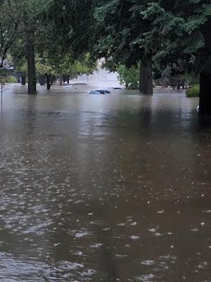
| @sarahkendzior took this photo of her St. Louis area street this morning. |
The situation was ongoing and it was still raining torrentially as I write this at 8 a.m. eastern time Tuesday. But as of 7 a.m. St. Louis had received 8.0 inches of rain it's wettest day in history. The old record was 6.85 inches.
At least an inch or two more rain seems likely as more storms were upstream. The National Weather Service there has declared this an emergency and a "particularly dangerous situation," words only used in weather warnings when the event is extreme.
Some areas near St. Louis have had ten inches of rain, and probably will have a foot of rain by the time the rain tapers off. This is considered a 1,000 year event which means there's a one in one thousand chance of this happening at any given time.
It does look like the rain will finally taper off in and around St. Louis by mid-morning.
The flooding is mostly in a narrow, 50 mile or so wide band from central Missouri, through St. Louis and on into south central Illinois. It's a classic "training storm" in which one thunderstorm after another goes over the same area like boxcars on a railroad track.
People were being rescued from homes and cars as I write this. News video from St. Louis includes two television reporters who were rescued by firefighters from a car that became swamped in the flash flood.
The Weather Channel reported some cars on highways were completely submerged, so we need to hope the people that had been in them were able to get out.
This is the beginning of a dangerous flash flood week in parts of the Midwest, Tennessee Valley and central Appalachians. A weather front has stalled in an west to east line from around Missouri to Virginia.
The kind of training storms St. Louis is experiencing could easily happen today, tomorrow and Thursday in parts of this region.
West Virginia is going to be a particularly scary trouble spot. It's been a really rainy summer there, so the soil is soggy. Heavy showers and thunderstorms are expected most of this week with up to 10 inches of rain in the forecast. The state has mostly steep mountainous terrain and lots of fast moving creeks. West Virginia is notorious for flash floods, and this could be one of the state's worst episodes.

No comments:
Post a Comment