Showing posts with label early spring. Show all posts

Tuesday, April 1, 2025

Vermont March Weather: Warm And Weird

A warm March sent daffodil shoots growing much
earlier than normal in Vermont this year. This new
spring greenery had to endure occasional wintry
setbacks, as seen here on March 21. That state
of affairs will continue into April. 
 Well, we got through another month, so it's time to look back at our overall Vermont weather in March, which, as you might have noticed was weird. And warm. 

MARCH TEMPERATURES

Burlington came in with a mean temperature for the month of 38.0 degrees. That puts us in a three way tie with 2010 and 1902 for the sixth warmest March on record. 

It's also the sixth time in a year a month in Burlington was in the top ten warmest list. 

This March was even warmer than the one a year ago, in 2024 which was merely the seventh warmest on record. Yeah, we've had a lot of hot Marches lately. A lot of hot months and years, actually, thanks to climate change. 

The entire rest of Vermont was much warmer than average in March, too. But figures are incomplete, as I noticed missing data on a few days from several of our regular long standing weather stations like Rutland and St. Johnsbury. 

The warmest March day in Burlington was 72 on the 19th and 20th.  This makes March, 2025 one of only 11 Marches in the past 140 years or so to get that warm.  It was not close to the hottest March day on record, though. It was 84 degrees in both March, 1946 and March, 1998.

Rapid snowmelt and some rain led to widespread, but minor flooding across Vermont around St. Patrick's Day. 

You could see the effects of such a mild March by the unusually early signs of spring. Crocuses were blooming by mid-month in a few locations. Green daffodil shoots poked up all through the second half of the month. The sound of returning red wing blackbirds filled the air in marshy areas way earlier in the month than usual. I even had a report of two of people in southern Vermont hearing spring peepers yesterday. That's really early for the season. 

Burlington had its final zero degree reading of the season on March 3. That meant nine days this past winter got to zero or below.  Historically we'd have roughly 20 or more such days per winter, so the downward trend in very cold days continues. 

MARCH PRECIPITATION

It was a little wetter than average virtually everywhere in Vermont in March, which is a good thing since we still have lingering effects from last autumn's drought. 

Precipitation wasn't overwhelming, though, as Burlington had 2.81 inches of rain and melted snow and ice. That's just a little over half an inch above average. By my count, Burlington had its 37th wettest March on record, so not all that impressive.

Precipitation around the state was similarly above average, but not to an extreme extent. 

Winter this March was notably absent until the end of the month. Early in the month, the summit of Mount Mansfield did have its highest snow depth since at least 2019.

But in most of Vermont aside from high elevations, very little snow fell into the end of the month. 

As we just saw, the last weekend of the month brought a big thump of five to nine inches of snow to the north, and a quite damaging ice storm to parts of central and southern Vermont.   

The snow and ice melted quickly during another very warm final day of March, though as of early yesterday, there was still 89 inches of snow near the Mount Mansfield summit. 

APRIL OUTLOOK

April is often regarded as a cruel month, as you think spring is coming, but you always end up getting slapped in the face with winter. 

That's no different this year. 

Today will be much colder than yesterday as many of us won't get out of the 30s. 

And, of course, Wednesday night, we're in for yet another round of snow, sleet and freezing rain. Though it won't be as bad as the last one, eastern Vermont in particular will likely see a glaze of ice, slick roads, and maybe an isolated power outage or two by early Thursday. 

The precipitation should change to rain on Thursday. 

Long range forecasts also call for mostly chillier than normal weather around here through at least the first half of April. We shall see. 

Even if it's a cool April, the forces of spring will win out. Normal temporaries rise rapidly. Today, the normal high temperature in Burlington is 48 degrees and the low is 30. By April 30, the normal high and low temperatures are 63 and 42 degrees.

You're going to see a much greener Vermont landscape by the end of the month compared to what it looks like now. 

Tuesday, April 16, 2024

As If You Need Confirmation, Spring Has Arrived In Vermont. And It's Early

 You see the daffodils and the crocuses, the greening grass and the buds on the trees. 

Areas shaded in red are where early plants like 
honeysuckle and lilac have started to leaf out. The red
means spring is arriving much earlier than normal
this year. As you can see, it's gotten into Vermont
as of this morning, though the mountains and
Northeast Kingdom are still waiting on this.
Spring seems to have arrived in Vermont. 

But if you need the official word on the precise arrival of spring, the National Phenology Network is here for your service. 

As I've written before, this organization has what is know as the first spring leaf index.  It indicates when particularly early species - specifically honeysuckle and lilac - start to sprout leaves.

And, as of today, these plants have started to leaf out in the Champlain Valley low elevations in southwestern Vermont and parts of the Lower Connecticut River valley.  Those leaves haven't quite appeared yet in the Green Mountains, north central and northeast Vermont. 

  By the National Phenology Network's (USNPN) estimation via the spring leaf index, the season is as much as  two weeks earlier than the long term average here in Vermont.  

Despite two spring snowstorm and temperatures that have only on a few occasional broken past 60 degrees, it's been pretty consistently warmer than average in Vermont all year, including in March and so far in April. 

Which has kept spring ahead of schedule around here.  On average, according the Network, a spring this early happens once in every four or five years, give or take. 

It's not just us.  Spring has been way ahead of schedule for most of the nation east of the Plains. According to USNPN: 

"The Sacramento Valley. coastal areas of northern California, Oregon, and Washington, and parts of the Great Plains and southern Midwest are seeing the earliest spring leaf out on record."

The exceptions to the early spring trend are in southern Texas and Florida where early spring leaf out hits in late winter.  It was a little cool down there at that point so they were slightly late

Of course, those far southern areas are now in full summer leaf.  

Over the next several days, temperatures across Vermont are forecast to be more or less near normal for this time of year. (Highs in the 50s, give or take, lows near or somewhat above freezing).

That means spring will continue to advance, but probably at a gradual pace. The Northern Vermont away from Lake Champlain might end up having an early spring, by USNPN standards, but maybe not quite as early as the banana belt of Vermont. 

This early spring obviously doesn't mean you can put out your tomatoes just yet. We have more frost to get through yet. Maybe even snow, who knows?

It's greening up out there, and it's nice to now see another color in the outdoor spectrum other than brown and gray.  I can get used to the increasing greenery out there. 

Sunday, April 16, 2023

Extreme April Heat In Vermont/New England Might Lead to Crop/Garden/Forest Damage

Earlier than ever. Green leaves were starting to make an
appearance behind my St. Albans, Vermont house this
morning while a lilac bush in the foreground leafs
out and gets ready to bloom. Record heat this past
week as pushed spring into the too-soon category.
When I got up this Sunday morning, some of the early growing trees behind the house shimmered with tender new green leaves. The lilac bushes were brimming with tiny floret buds, ready to put on a show. 

I've never seen that kind of thing happen so early in Vermont.  It's truly remarkable.

This spring had been proceeding at a fairly average, comfortable, pedestrian pace, until the unprecedented early season heat arrived this week. 

Western Vermont won the heat prize Saturday. In Burlington, the record high Saturday was 85 degrees, breaking the old record of 82 set in 2003,

Everything springtime related leapt ahead far ahead of schedule. Things are where they should be around the first of May.  This race through spring will continue today with temperatures that will be far, far above normal again today. 

The summer party ends tomorrow with sharply cooler air.  Long range forecasts are suggesting that the second half of April might actually be chillier than normal.

If this cooler air is just kind of chilly without hard nighttime freezes, that will be good. It will just slow down the progress of spring and start to bring us more in line with where we should be.

Light to moderate freezes, temperatures that stay at or above, say, 28 in the Champlain Valley and in the mid 20s or better in much of the rest of northern Vermont between now and early May probably wouldn't cause much damage. Unless these readings are accompanied a lot of wind. 

 But it can get as low as the teens this time of year in most of the Green Mountain State that would be a disaster.

This coming week won't be a disaster, despite a particular chill in the air Tuesday and Wednesday. At least we'll get a little rain out of this shift to colder weather.  We need it. 

There's a good chance we'll have  widespread frosts and freezes Wednesday night, but I really doubt it will get cold enough to cause any real harm. 

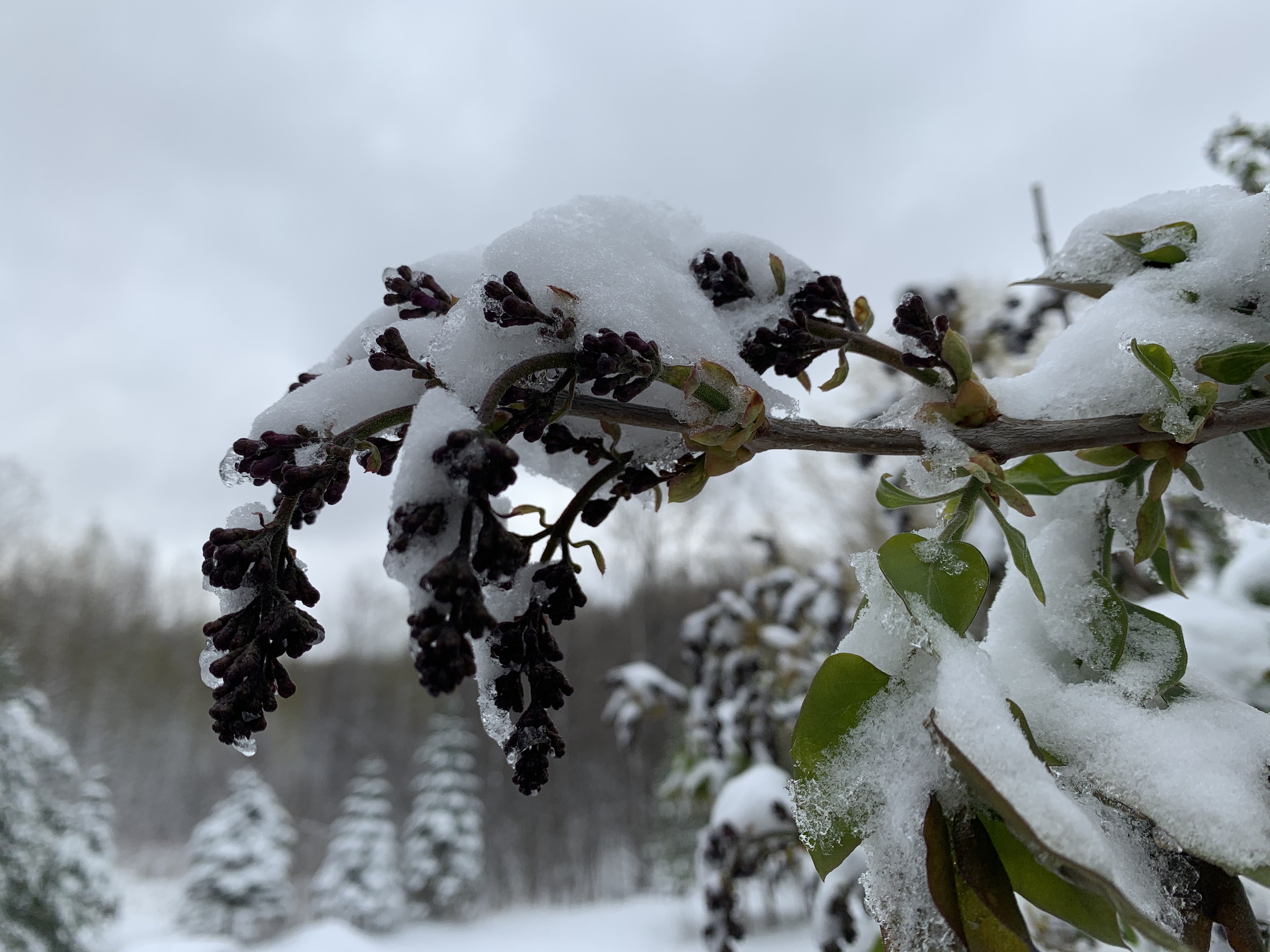
This budding lilac floret, pictured here on April 22, 2021,
froze to death and never bloomed after a late season
snow and freeze that year. This highlights the danger of
what could happen if spring growth comes too soon.

However, if you brought your tender planters outside to enjoy the warmth, you'll need to bring them back indoors this week. 

My hibiscus has enjoyed the warm sun this week, for instance, but I'm locking it in the house and turning up the heat a bit when it gets cold starting this week. 

In the short term, we're safe, but I don't know how cold it might get in late April. 

These strange spring heat waves have already led to sometimes disheartening, or even costly damage.

A record early heat wave in Vermont back in 2002 brought the earliest 90 degree reading on record to Vermont on April 17 the year. Leaves on trees started coming out almost as soon as they are this year. 

Late in the month, hard freeze destroyed garden plants, and blackened swaths of forest by killing the early leaves. The visible damage lasted well into June before new leaves grew.  Trees being forced to re-leaf stresses them, in much the same way that spongy caterpillars did in Vermont last year and the year before,

Trees can usually withstand on year of defoliation, but if it happens year after year, it takes a toll. 

Other times, the damage from weird early heat is not so costly, but just a little depressing. 

Early spring, 2021 was warm and things were blooming early.  On April 21 that year, lilac trees were already displaying budding florets, and crabapple trees were just starting to bloom. 

Then a snowstorm and harsh freeze hit northwestern Vermont.  Some of the crabapple trees never really bloomed that year as a result. Many of the lilacs ended up stunted, only partially blooming.  Living without the annual spring display of full-blown lilacs was surprisingly depressing. 

Climate change has brought too-early heat waves that encourage too-early spring growth frequently in recent years. Sometimes, in the eastern United States, this has brought widespread agricultural damage, as the Southeastern U.S. saw in 2012 and 2017 and to a lesser extent earlier this year. 

That's not to say freezes are guaranteed to ruin our Vermont spring this year. The fact that it has come too early, though, leaves us prone to trouble. The best bet is just to hope for normal late April weather once this heat wave finally dies after today. 

Friday, March 24, 2023

The March Spring Thaw Is Both Ugly And Beautiful. In Video And Pics

The March melt and mud season in Vermont isn't the 
state's prettiest look, but it can have its quiet
anticipatory beauty. 
 March in Vermont this year is turning out the way it was when I was a kid decades ago

As we get into the closing week of the month, the snow cover is finally starting to lose the battle to spring. But only grudgingly.

Video of this year's March melt and mud is at the bottom of this post.  

 One day we have some strong sun that opens up more bare patches in the reflected sun's heat near the pine trees. The next day, rain washes some of the crusty old ice and snow away.  

It's an old fashioned year. Under our  climate change regime, we've gotten these weird, warm days in March which disappeared early in the month, and got the crocuses blooming way early - sometimes by St. Patrick's Day. 

Not this year. It actually feels a bit novel to have a throwback March like this. Though even this March is running somewhat warmer in Vermont than the long term average.  

This isn't the prettiest time of year. Old snow sort of half-heartedly glows under the overcast next to expanses of brown grass in open fields. Mud is everywhere. Along road sides, litter that has been buried in snow now glares at us with its own ugliness as we pass by in our mud-flecked and road salt encrusted cars. 

But this "ugly"  seasons is also hopeful, and in a strange way beautiful. On rainy days, the fog curls over remaining patches of snow, as if the damp south wind is trying to steam away the remaining ice. The melting snow and is cheered on by the calls of newly arrived red wind blackbirds. 

Garden plants have gotten used to getting an early start, thanks partly to climate change. This year, an odd, balmy January got daffodils, crocuses trying to come up in mid-January. Only to be denied in active. February and March snowfalls.

These daffodil shoots in St. Albans, Vermont aren't waiting
for the snow to melt to get on with the spring show. 
But the head start was already there, so these early perennials are in a premature schedule. It looks like they're saying, "Screw it. I know there's still a bunch of snow on the ground, but I'm coming on strong anyway."

 So daffodil shoots are popping up through the tops of fading snowbanks. 

Spring this year continues on in its uncertain fashion.  A new storm is probably going to give us a headache inducing mix of rain, ice and snow Saturday and Saturday night. 

Current forecasts don't indicate too much snow and ice accumulation in the valleys, but you never known. We could end up being tricked. Even if we don't. it'll slow down our spring melt a bit.  

There's also no spectacularly warm spring days in the immediate forecast. Eventually, real spring will come. But the tentative daffodil shoots, the mud and yes, even the roadside litter gives us hope that greener, warmer days are around the corner.   

Watch the video below to see what I mean by all this. It starts with a sunny phase of the thawing Wednesday, and moves on to the rainy phase on Thursday. Either click on this link to view, or if you see the image below click on that.


Sunday, February 19, 2023

Major Temperature Contrasts Spell Stormy U.S. Trouble For Upcoming Week (Vermont, Too!)

5:30 PM SUNDAY UPDATE
Sheets of ice from Friday's freezing rain, sleet and hail
slowly melt and slide off my roof in St. Albans,
Vermont on Saturday. Mild weather should 
continue for a few days, with a potential big
storm by around Thursday.

Little change in the forecast since this morning, but it looks like winter will make an appearance later this week and possibly last awhile.

All indications are we should see a good thump of snow on Thursday. There's still the possibility of mixed precipitation of course.

Somebody will probably get a very nasty, damaging ice storm out of this. But, fingers crossed, at this point the worst ice
looks like it might be very roughly along a Buffalo, New York to southwestern New England line, 

Obviously, that forecast could change pretty dramatically. Stay tuned.

Of course, I don't want anybody to have a damaging ice storm, but, selfishly, I'd rather it not be in Vermont. 

After the storm departs around Friday, it's looking like we'll have the coldest weather since the brief Arctic outbreak on February 3-4.  This one won't be as bad as that, but some of us could easily go below zero at the end of the week or the beginning of the weekend. 

PREVIOUS DISCUSSION

Hang on to your hats. Another round of weird weather extremes is about to hit the U.S. This includes widespread record warmth, severe weather, tornadoes, widespread snow and freezing rain, and strong winds.   

We here in Vermont will be included in some of this fun. More on that further below. There's a lot to unpack here, so let's get started. 

RECENT RECORDS 

Before I get into the upcoming weird week, I have to touch on the weirdness of this past week. 

As I said in previous posts, we had our share of record highs last week in Vermont. At Burlington we managed to get to 33 degrees just before midnight Saturday. That brings us to 14 consecutive days that got above freezing, quite an incredible streak for a Vermont February.  

Tuesday or more likely Wednesday will be the first subfreezing day since February 4.   

Elsewhere, several cities hit all time record highs for the entire month of February. They included 70 at Kingston, Rhode Island and New Bedford, Mass; 71 in Islip, New York and Groton, Connecticut.  New York City had its warmest February overnight low on Thursday, only dipping to 58 degrees. 

By the way, after record warmth in Vermont Wednesday and Thursday, Springfield, Vermont managed to eek out a record high of 49 degrees Friday before the icy cold front reached them. 

All this has led to a premature spring in the East, which will probably end in a destructive freeze sometime in March. Daffodil shoots continue to grow at my house in St. Albans, Vermont, barely a 20 minute drive from the Canadian border. Magnolias are blooming in Washington DC. Honeysuckle and lilac leaves are beginning to sprout as far north as New York City. 

Such extreme early signs of spring does make one worry a bit more about climate change. 

EASTERN SPRING GETS WEIRDER

This dangerously early spring will continue. Record warmth is likely in much of the eastern U.S. outside of New England later this week, which will just be sort of warm-ish for the season.   

The whole weather pattern is setting up to feature big temperature contrasts, which are a recipe for storms. Some of which could possibly be dangerous. 

The warmth coming up in the Southeast looks like it will be just wild. Temperatures are forecast to reach 90 to 95 this week in much of Florida, which could break all time records for the month of February. Normal highs in central Florida this time of year are in the mid-70s.

Temperatures later this week could get to 80 as far north as Virginia. 

One forecast map out of many for Thursday. The 
idea shows a wide ranging, coast to coast storm'
to cause a variety of nasty to dangerous 
weather, including here in Vermont. 

There's been a ridge of warm high pressure over the Southeast pretty much all winter. This brought a mostly springlike winter for most places east of the Mississippi River. That "heat ridge" will intensify further this week. 

Of course, it is winter, so it's cold north and west of the the Southeast heat ridge. 

That has led to a parade of storms that have unleashed repeated severe weather and tornado outbreaks near the Gulf Coast, repeated winter storms in the central and northern Plains, and our own weird misery of rain, mixed precipitation and warmth here in Vermont. 

While the Southeast bakes, record lows should hit parts of the West Coast this week. This big, big contrast means storms. 

We are looking at a big storm to form in the middle of the week. Big at least in the size of the area it will cover. Snow will fall mid to late week from Washington State across the northern tier of states all the way to Maine. 

Somewhere just south of that, it looks like a broad stripe of freezing rain and sleet will extend from the Plains to New York, Pennsylvania and New England. Or at least near those places, give or take. 

The storm will generate yet another round of severe storms and tornadoes in the Deep South Wednesday and possibly Thursday. Strong winds will blow in large parts of the Midwest, Plains and Rocky Mountains. 

The weather is really going to be in the national news later this week. 

VERMONT EFFECTS 

It looks like the Green Mountain State will escape any major weather until about Thursday. At that point, things look like they'll get interesting to say the least.

Before we get there,  we've got a couple little storm systems to deal with. Neither will mess up your life too much. 

The first and weakest of the storms comes through tomorrow. It will just spit out some valley rain showers and maybe some snowflakes in the mountains. Look for less than an inch of snow up high, and enough rain to barely wet the ground in the lowlands.

Another, slightly strong storm is scheduled to zip through west to east Tuesday and Tuesday night. Again it'll be warm, so we'll see some rain and snow showers.  The storm's cold front Tuesday night might produce brief, somewhat heavier snow showers. But this won't be a tremendous storm, either.

Then the potential biggie.

Remember that large zone of record heat building in the Southeast?  The incoming storm will cause a big rush of that super heated air to start flowing northward. Meanwhile, dense, cold air will build up in Quebec. 

We won't feel that record hot air. Instead, it will be forced to glide up and over that dense cold air. Rising air means precipitation. Since the air is so warm and coming in such a rush, and that cold air will create such lift, we have some potential to see some heavy precipitation of some sort. 

Problem is, we're not sure yet exactly what will fall out of the sky.  

The early thinking is it'll start as a thump of pretty heavy snow, followed by a surge of sleet and possibly freezing rain. Then it would flip back to snow at the end late Thursday or Thursday night. 

That's just an early guess, though, and this storm could still turn out much differently than that.

We don't know how far north in Vermont the mixed precipitation will reach, though it seems most likely in southern parts of the state. There's a decent chance of at least some of us seeing a good six inches of snow or more. Maybe even much more. But we don't know the ins and outs of that, either. 

We also don't know if the weather in Vermont will get as weird as it did Friday, with those sharp temperature contrasts, thunderstorms, hail, ice and whatnot. 

As we get closer to the event, meteorologists will surely, gradually iron out the details. At this point, if you have travel plans, I can tell already that Thursday will not be your day.  

Thursday, April 7, 2022

Loving And Fearing Early Springs: Season Comes Sooner, But Cold Snaps Loom

Although it doesn't look like much yet, one of my
perennial gardens in St. Albans, Vermont is way ahead of
schedule this warm spring. However, these early
bouts of warmth increase the risk of freeze damage later.
So far at least, it's yet another early spring here in northern Vermont. 

Like many recent springs,  things are way ahead of schedule, or at least the schedule as it used to be.  

This week here in northwest Vermont feels and looks like what the third week in April used to look like when I was a kid in the Green Mountain State.

On Wednesday, trees were budding in the sunny, warm breezes. The grass was starting to turn green, perennials in the gardens were up and growing rapidly.  Crocuses bloomed everywhere and some of the early daffodils showed flower buds already. 

The only negative thing was that black flies were starting to bother me a little, weeks ahead of schedule.

Actually that's not the only thing that bothered me about this early spring. The trend, anecdotally around here in Vermont and observed in much of the Northern Hemisphere is this: Climate change is creating early springs. Plants are greening up and blooming earlier than ever, at least in general.

However, brief but intense cold snaps are causing lots of crop and garden damage. And that's not to mention how dispiriting it is to watch your early gardens freeze to death.

Here in Vermont, there's no immediate sign of any looming cold snaps sharp enough to wreck spring, but that doesn't mean it won't happen.

These frigid spells have damaged gardens and such in the two previous premature springs, so chances are it will happen this year, too.

This kind of pattern has already happened elsewhere this spring, and in recent years.    

It had been a warm winter and spring across much of Europe, so plants, crops and fruit trees began blooming prematurely.

Then a blast of winter chill blew in this past weekend. 

They're still assessing the damage, but farmers and agricultural experts know it's extensive. Plum, apricot and cherry orchards in France have been damaged, as has many of its famed vineyards.  

France had its coldest April morning since 1947 with a low of 29.3 degrees. Record lows were also reported in Germany, Spain and Austria.

This is the second year in a row Europe suffered a harsh spring cold wave after a warm winter. 

As the Washington Post notes, last year's cold snap caused $2.4 billion in damage to French wine growers. Some vineyards lost 80 percent of their grapes.

The damage might not be as bad this year, because the cold hit earlier than in April, 2021. Buds and blooms were not as far along as they were during last year's freeze, so that could minimize the destruction. 

Sharp, destructive cold waves during otherwise warm springs seem to be becoming a thing. Says the Washington Post:

"Climate scientists are concerned that warming late winter and early spring temperatures are increasing the frequency of 'false springs' which spur earlier vegetation green-up before the threat has passed of frigid temperatures that can wipe out young, vulnerable plants."

In the Northeast, a cold shot in the final days of March trashed magnolia blooms, wilted some other early flowers and many have caused some orchard damage in parts of the Mid-Atlantic States

The Washington Post has other examples:

"A false spring in March, 2012 was followed by an April freeze that resulted in a half billion dollars in damage in Michigan. A false spring in 2017 and ensuing early April frost resulted in $2 billion in economic damage in the Southeast."

A 2019 study concluded that despite overall warming temperatures, some plant and crop species will paradoxically suffer a trend of increased frost damage due to more premature springs punctuated by quick freezes. 

The problem extends way past plants. Audubon.org notes that earlier, warmer springs prompt birds to migrate northward earlier than they once did. Some species of birds directly freeze to death if they go north, then encounter a sharp freeze.

Or, insects go dormant during the cold snap, so birds that feed on insects suffer or even die. Or, plants that are a food source for our avian friends die in a freeze after a false spring, so that causes issues. 

Audubon.org suggests adding bird feeders and water sources to your property to help the birds through our newly whacky springs.  By the way, animals might come out of hibernation of the late winter is like spring. Then they find out the plants they feed on were wiped out by an April freeze.

Or, blooms on plants like wild apple and various nut species freeze after a premature spell of warm weather, so animals are not able to find enough food during the subsequent autumn.

Then there are us humans.  There's the obvious toll if somebody's vineyard or apple orchard gets trashed by a spring frost after an early bout of record high temperatures. 

At least for me, this pattern of premature springs followed by damaging freezes is dispiriting.  I'm an avid gardener, and the familiar patterns of seasonal changes are important to me. Always have been. I'm a close observer of day to day changes in the natural world around me, and I can spend hours outdoors just marveling at how seasons unfold, especially spring. 

I'm rather neurodiverse, so forgive me for my indulgence there. As my husband always says, I love going outside and playing in the dirt. 

It actually feels soul crushing to watch some perennials die, say in a Mother's Day weekend freeze two years ago.  Last year, a very early spring led to an April 21-22 sharp freeze and snowstorm that destroyed wild apple blossoms near my house, smushed some of my daffodils, and worst of all, largely prevented my lilac bushes from blooming due to frost damage.

Even the joy of this year's early spring is tempered by the inevitable hard freeze I fear will come sometimes within the next month or so.

I realize those freezes were not exactly the end of the world for me, as I suffered no real monetary loss and my gardens ended up looking fine during the summer. But to have the exuberance of an early spring trashed by two days of winter cold is just one more small, but real example how climate change can mess with your mind.