Showing posts with label frosts. Show all posts

Friday, May 8, 2026

May Is The Season Of Spring Frosts, But So Far We're Avoiding Freezes . No Guarantees Though

Some of our plants are in the living room window
and some tropical plants went into dormancy in a 
spare bedroom in our St. Albans, Vermont house.
We're waiting for the threat of frost to be over
before bringing them outdoors for the summer.
We're hoping the frost threat ends 
within another week or so, fingers crossed.
 I'm reluctant to release our tropical plants like the orange tree and the hibiscus from their winter prison in our small, but somewhat sunny spare bedroom.  

We've had some nice warm days that they would have enjoyed outdoors on the deck. But this cool weather pattern we're stuck in has us worried about frost. Which, as Captain Obvious would say, is bad for tropical plants. 

So far, clouds and wind have kept overnight temperatures above freezing, and we're hoping that continues. But, we have the National Weather Service to rescue us from tragic hibiscus deaths if we choose to bring the plants outdoors in the coming days. 

They're always good with the frost alerts. There's also a schedule for the spring frost and freeze advisories. 

The National Weather Service won't issue frost or freeze advisories until the growing season starts in a given spot. The growing season is defined as the period between the average date of the last spring freeze and the average date of the first fall freeze. 

Frost and freeze advisories and warnings started on May 1 in the Champlain Valley on nights when conditions warrant.  In most of the rest of Vermont, the National Weather Service won''t start with those advisories until May 11. In the Northeast Kingdom, you wouldn't hear a frost or freeze alert until May 21 and after.

That explains why you might see a frost advisory in early May for the Champlain Valley, but no freeze alerts for the rest of Vermont, even though it's colder there. 

In those areas away from the Champlain Valley, National Weather Service forecasts until May 11 will mention frosts if some is expected, but won't actually issue a frost advisory or warning until that growing season starts.

We will be subject to a frost risk for awhile yet. Hard freezes have hit Burlington as late as May 31, and light frosts have historic hit in early June on a few occasions. In the Northeast Kingdom, there's been frost every month of the year. Though recent summers up that way have been frost-free.

ACTUAL FROSTS?

We're keeping our eyes out for frosts as it is cooler than normal for this time of year. Any night over the next several days in which skies clear and winds go calm gives us a risk of frosts.

That might be tonight, but the Champlain Valley might be a couple degrees too warm for frost. We'll get updates this afternoon. If temperatures forecasts are adjusted downward, we'll get a frost advisory for the Champlain Valley, but for now, we're in the clear. 

Forecasts do mention frosts for the rest of the state, so if you are anywhere outside the Champlain Valley, sensitive plants should come indoors tonight. 

After a brief, sort of warmup this weekend, I think the risk of frost might come back for the first half of next week. Again, depending on how cloudy and breezy the nights are. On the bright side, I'm not seeing any signs of a really hard freeze. Just nights that get dangerously close to the freezing mark.k 

Remember, you can get frost even if temperatures are in the mid-30s. We measure temperatures about five feet off the ground. It's amazing how much colder it can be on still nights down near your feet.

We don't want to take our tropical plants outdoors until we're reasonable sure no more frosts are coming. Those plants and the soil-filled, large pots they are in are heavy!  We're too old to move them back and forth every night. 

There are signs that we might shift to a warmer weather pattern around May 18 or so. Then I can finally free Margaret (our orange tree) and Hector the hibiscus and the other plants out to the freedom of our outdoor deck, where they are happiest. And I am, too.  

Friday, August 15, 2025

Cooldown Coming To Vermont (Eventually) But No Throwback To "Frigid' Augusts Of The Past

If you're tired of the smoky, hazy, hot air we've experienced
in Vermont this summer, I present you with this image
of a crystal clear, clean frosty day, taken Feb. 4, 2021.
 We've still got a few more warm days to go before the strongest cold front since early June blows in on Sunday. 

Dry weather will mostly continue, keeping me concerned that a flash drought is starting. At the very least, Vermont will remain abnormally dry. 

The drying trend will continue big time today.   We can expect sunshine, warm temperatures and very dry air.  

The dew point - a rough measure of how humid it is out there, will stay relentlessly low today. Those dew points could fall into the upper 40s this afternoon which is quite arid for an August afternoon in Vermont.

We've still got a quick squirt of very warm to hot air coming in Saturday. The warmer valleys could reach 90 degrees which might well be the final day this year of 90 degree heat. We don't know for sure, of course, as sometimes we get heat waves into the first half of September.

The humidity will only rise modestly, so our crops and gardens will continue to get more and more parched. 

The cold front Sunday means business, but only in terms of temperature. At this point, rainfall looks lame with it, amounting to a quarter inch or less. Maybe a little more than that north, maybe a little less south. A few pinpoint places could get a little more in local downpours, but it won't be anything exciting. 

You'll certainly notice the temperature drop behind the cold front.  You'll feel it cooling off quite a bit  later in the day Sunday. By Monday, highs will only make it to within a few degrees of 70. Monday night will be in the 40s for most of us. 

There's a slight chance we'll get lucky and the cold front will stall just to our south. If that happens, a storm might form along it and give us a little more rain Tuesday. Especially south. But that scenario is iffy at this point. I'm not holding my breath yet for any showers then.

It will only slowly warm up the rest of next week, but still stay slightly cooler than average. Nothing unusual for August. We will be nowhere in the league of notable chilly Augusts of the past.  

PAST COLD AUGUSTS

The Death Valley heat earlier in the week was definitely a bit much.  But let's face it, at least we're getting a summer.  They're kind of short here in Vermont, even with climate change, but you want to at least get through most of June, July and August with at least several days of beach weather. 

It wasn't always like this.  We've had our share of disappointing Augusts that masqueraded  as Septembers.  

It started in the cold summer of 1962, when August four consecutive days mid month in which highs never got out of the mid-60s. 

Then came 1963. That year, only seven August days made it as high as 80 degrees, with the warmest being 84.. (For comparison, this year, we're only halfway through the month and Burlington has had 14 days that were at least 80 degrees.  

In 1963, eight days never made it to 70 degrees. One day, the 13h had a low of 46 a high of just 59 with over a half inch of rain. In other words, a somewhat raw October day in the middle of August .

The next year, August, 1964, brought slightly warmer afternoons, but way to chilly nights. Fifteen mornings that month in Vermont's banana belt of Burlington got under 50 degrees. On both August 1 and August 7, there was frost in some of the cold hollows of Vermont. On August 1, the temperature got down to 30 in South Londonderry and 32 in both Chelsea and Somerset.   

August, 1965 brought some summer weather early in the month, but fall made a very strong, early showing toward the end. Daytime temperatures stayed in the 50s for the final three days of the August, 1965  culminating in a hard freeze in some spots on August 31,

It got down to 25 degrees in South Londonderry, 26 in West Burke and 27 in Northfield. 

For the remainder of the 1960s ,each August was also cooler than normal, but not as bad as the years I mentioned here.

I don't know why 1960s summers were so chilly. It could have been just a natural cycle. Particulate and sulfur pollution in that era might have blunted the warmth of the sun a bit, too.  

Now that climate change has taken hold, it's highly unlikely we'll have such cold Augusts that we had in the 1960s. We'll still have relatively chilly Augusts from time to time. After all, climate change has not stopped weather patterns from bringing cooler air down from Canada. 

But that climate change has altered our perspective of summers. Actually the whole year.  The chances for hot Augusts, or hot any month are way up. For August, the top four hottest Augusts in Burlington have all happened since 2016. 

Burlington has 15 years in the top ten list of hottest summers due to ties. (Measured as temperatures between June 1 an August 31).  Eight of those hottest summers have happened since 2005, and there's a chance this summer might join this list. 

As I always like to say, this ain't your grandfather's climate. 

Sunday, April 23, 2023

Spring Is Over For Now In Vermont. Enjoy The Chill, Showers, Clouds Into May

An emerging spring sugar maple leaf amid today's
rain in St. Albans, Vermont. 
Did you love the warm, sunny weather Friday afternoon?  Was Saturday OK for you, with its relatively mild temperatures and lack of rain?  

Hope you didn't miss out on it! It'll be awhile before such weather is back.

GLOOMY WEEK?

As forecast, a drenching rain is falling across Vermont today.  It's gotten to be on the dry side for this time of year. So the gloomy day long raindrops are a good thing, despite the fact it's interfering with outdoor fun and work. 

Most of us can expect total rainfall through tomorrow morning to run over an inch.  Not enough to cause any flooding, but you will see rivers go up and run fast without quite spilling over their banks.  It'll be pretty soggy underfoot, too. 

The problem is, the wet weather isn't just a today thing. Clouds, showers and cool weather are now here for an extended stay. 

As often happens in the spring, the weather pattern gets stuck.  More often than  not, when the weather gets stuck, we in Vermont get the cloudy end of the stick. 

High pressure way up in northeastern Quebec will prevent the storm causing today's rain from really moving away. 

So, the risk of showers - and mountain snow showers - will continue pretty much all week. 

That's not to say you won't see the sun at all. It'll peek through from time to time, especially as we get later in the week. 

But with the storm lingering, at least in the upper atmosphere, cold air will sit over us. Especially in the higher levels of the atmosphere. If the sun breaks through the clouds, it will heat the ground  a bit, cause updrafts, interact with the chilly air above and create showers. 

Spring foliage begins to emerge on a rainy Sunday in
St. Albans, Vermont while daffodils look on in the background.
At least we'll see gradual improvement as the week goes on. Monday will be almost a washout. You'll probably dodge a lot of mostly light showers Tuesday.  Breaks between showers will last longer Wednesday through Friday.  

It's hard to say when this weather pattern will fully break.  This kind of thing can last one week, two weeks, even three weeks in some cases. The computer models that meteorologists at least partly rely upon aren't good at predicting when these blocky weather patterns will loosen up. 

For now, the iffy long range forecasts have us in a cool, showery pattern through the first week of May.  This prediction is subject to change, of course. 

BRIGHT SIDES

There are bright sides to all this. 

So far at least, forecasts indicate the core of the coldest air seems like it wants to go by to our south and west. Those long range forecasts seem like they want to keep the coldest air, relative to average, off to our south and west. Mostly in the mid-Mississippi and Ohio river valleys.  

A broad area in the Midwest from Nebraska to Ohio are under freeze warnings tonight. Some areas in th Midwest and Plains could see record low temperatures. 

Chances are we in Vermont will be on the chilly side most days into early May, but it might not be so extreme or consistent.  At this point, we see chances of the usual light freezes we get this time of year, but nothing record breaking. Chances are also greater than average that we will be somewhat wetter than average into early May. 

That doesn't sound like we will have enjoyable weather, but it has its benefits. For one, spring is way ahead of average, which puts at risk for damage from late frosts. Cool, cloudy weather will stall the progress of spring, which will prevent even more frost and freeze vulnerability. 

Second, the clouds will likely prevent temperatures from getting too cold at night, which would prevent the risk of frost damage. 

Also, for the past couple of years, Vermont has been battling the horrible spongy caterpillars (formerly known by a name that included an eastern European slur). These disgusting insects deforested much of Vermont's landscape in the early summers of 2021 and 2022.

Damp, drizzly, foggy weather in the spring encourages a type of fungus that has absolutely no effect on us humans. But it  can decimate spongy caterpillar populations. We can only hope. 

The weather pattern also has a bright side for the whole nation, too.  It will suppress (though not entirely eliminate) the chances of severe weather and tornadoes for at least the next week or so. 

Which makes cloudy, chilly, wet spring skies easier to take. 


Sunday, April 16, 2023

Extreme April Heat In Vermont/New England Might Lead to Crop/Garden/Forest Damage

Earlier than ever. Green leaves were starting to make an
appearance behind my St. Albans, Vermont house this
morning while a lilac bush in the foreground leafs
out and gets ready to bloom. Record heat this past
week as pushed spring into the too-soon category.
When I got up this Sunday morning, some of the early growing trees behind the house shimmered with tender new green leaves. The lilac bushes were brimming with tiny floret buds, ready to put on a show. 

I've never seen that kind of thing happen so early in Vermont.  It's truly remarkable.

This spring had been proceeding at a fairly average, comfortable, pedestrian pace, until the unprecedented early season heat arrived this week. 

Western Vermont won the heat prize Saturday. In Burlington, the record high Saturday was 85 degrees, breaking the old record of 82 set in 2003,

Everything springtime related leapt ahead far ahead of schedule. Things are where they should be around the first of May.  This race through spring will continue today with temperatures that will be far, far above normal again today. 

The summer party ends tomorrow with sharply cooler air.  Long range forecasts are suggesting that the second half of April might actually be chillier than normal.

If this cooler air is just kind of chilly without hard nighttime freezes, that will be good. It will just slow down the progress of spring and start to bring us more in line with where we should be.

Light to moderate freezes, temperatures that stay at or above, say, 28 in the Champlain Valley and in the mid 20s or better in much of the rest of northern Vermont between now and early May probably wouldn't cause much damage. Unless these readings are accompanied a lot of wind. 

 But it can get as low as the teens this time of year in most of the Green Mountain State that would be a disaster.

This coming week won't be a disaster, despite a particular chill in the air Tuesday and Wednesday. At least we'll get a little rain out of this shift to colder weather.  We need it. 

There's a good chance we'll have  widespread frosts and freezes Wednesday night, but I really doubt it will get cold enough to cause any real harm. 

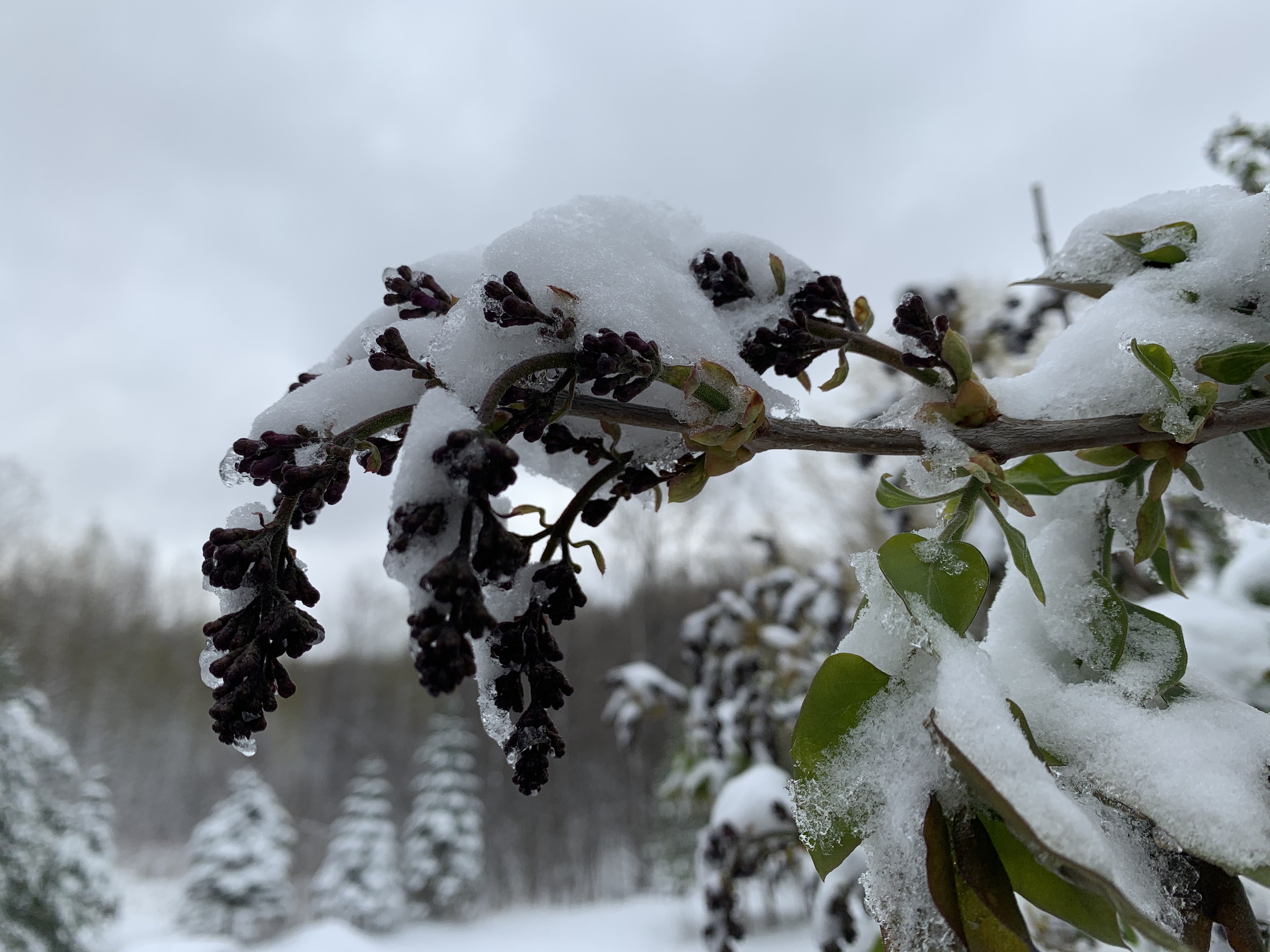
This budding lilac floret, pictured here on April 22, 2021,
froze to death and never bloomed after a late season
snow and freeze that year. This highlights the danger of
what could happen if spring growth comes too soon.

However, if you brought your tender planters outside to enjoy the warmth, you'll need to bring them back indoors this week. 

My hibiscus has enjoyed the warm sun this week, for instance, but I'm locking it in the house and turning up the heat a bit when it gets cold starting this week. 

In the short term, we're safe, but I don't know how cold it might get in late April. 

These strange spring heat waves have already led to sometimes disheartening, or even costly damage.

A record early heat wave in Vermont back in 2002 brought the earliest 90 degree reading on record to Vermont on April 17 the year. Leaves on trees started coming out almost as soon as they are this year. 

Late in the month, hard freeze destroyed garden plants, and blackened swaths of forest by killing the early leaves. The visible damage lasted well into June before new leaves grew.  Trees being forced to re-leaf stresses them, in much the same way that spongy caterpillars did in Vermont last year and the year before,

Trees can usually withstand on year of defoliation, but if it happens year after year, it takes a toll. 

Other times, the damage from weird early heat is not so costly, but just a little depressing. 

Early spring, 2021 was warm and things were blooming early.  On April 21 that year, lilac trees were already displaying budding florets, and crabapple trees were just starting to bloom. 

Then a snowstorm and harsh freeze hit northwestern Vermont.  Some of the crabapple trees never really bloomed that year as a result. Many of the lilacs ended up stunted, only partially blooming.  Living without the annual spring display of full-blown lilacs was surprisingly depressing. 

Climate change has brought too-early heat waves that encourage too-early spring growth frequently in recent years. Sometimes, in the eastern United States, this has brought widespread agricultural damage, as the Southeastern U.S. saw in 2012 and 2017 and to a lesser extent earlier this year. 

That's not to say freezes are guaranteed to ruin our Vermont spring this year. The fact that it has come too early, though, leaves us prone to trouble. The best bet is just to hope for normal late April weather once this heat wave finally dies after today.