Showing posts with label freezes. Show all posts

Friday, May 8, 2026

May Is The Season Of Spring Frosts, But So Far We're Avoiding Freezes . No Guarantees Though

Some of our plants are in the living room window
and some tropical plants went into dormancy in a 
spare bedroom in our St. Albans, Vermont house.
We're waiting for the threat of frost to be over
before bringing them outdoors for the summer.
We're hoping the frost threat ends 
within another week or so, fingers crossed.
 I'm reluctant to release our tropical plants like the orange tree and the hibiscus from their winter prison in our small, but somewhat sunny spare bedroom.  

We've had some nice warm days that they would have enjoyed outdoors on the deck. But this cool weather pattern we're stuck in has us worried about frost. Which, as Captain Obvious would say, is bad for tropical plants. 

So far, clouds and wind have kept overnight temperatures above freezing, and we're hoping that continues. But, we have the National Weather Service to rescue us from tragic hibiscus deaths if we choose to bring the plants outdoors in the coming days. 

They're always good with the frost alerts. There's also a schedule for the spring frost and freeze advisories. 

The National Weather Service won't issue frost or freeze advisories until the growing season starts in a given spot. The growing season is defined as the period between the average date of the last spring freeze and the average date of the first fall freeze. 

Frost and freeze advisories and warnings started on May 1 in the Champlain Valley on nights when conditions warrant.  In most of the rest of Vermont, the National Weather Service won''t start with those advisories until May 11. In the Northeast Kingdom, you wouldn't hear a frost or freeze alert until May 21 and after.

That explains why you might see a frost advisory in early May for the Champlain Valley, but no freeze alerts for the rest of Vermont, even though it's colder there. 

In those areas away from the Champlain Valley, National Weather Service forecasts until May 11 will mention frosts if some is expected, but won't actually issue a frost advisory or warning until that growing season starts.

We will be subject to a frost risk for awhile yet. Hard freezes have hit Burlington as late as May 31, and light frosts have historic hit in early June on a few occasions. In the Northeast Kingdom, there's been frost every month of the year. Though recent summers up that way have been frost-free.

ACTUAL FROSTS?

We're keeping our eyes out for frosts as it is cooler than normal for this time of year. Any night over the next several days in which skies clear and winds go calm gives us a risk of frosts.

That might be tonight, but the Champlain Valley might be a couple degrees too warm for frost. We'll get updates this afternoon. If temperatures forecasts are adjusted downward, we'll get a frost advisory for the Champlain Valley, but for now, we're in the clear. 

Forecasts do mention frosts for the rest of the state, so if you are anywhere outside the Champlain Valley, sensitive plants should come indoors tonight. 

After a brief, sort of warmup this weekend, I think the risk of frost might come back for the first half of next week. Again, depending on how cloudy and breezy the nights are. On the bright side, I'm not seeing any signs of a really hard freeze. Just nights that get dangerously close to the freezing mark.k 

Remember, you can get frost even if temperatures are in the mid-30s. We measure temperatures about five feet off the ground. It's amazing how much colder it can be on still nights down near your feet.

We don't want to take our tropical plants outdoors until we're reasonable sure no more frosts are coming. Those plants and the soil-filled, large pots they are in are heavy!  We're too old to move them back and forth every night. 

There are signs that we might shift to a warmer weather pattern around May 18 or so. Then I can finally free Margaret (our orange tree) and Hector the hibiscus and the other plants out to the freedom of our outdoor deck, where they are happiest. And I am, too.  

Monday, February 2, 2026

No Power, More Deaths Sea Tragedy, Cleanup Woes In Wake Of Two Winter Storms

The remains of four houses the collapsed into the sea in
Buxton, Outer Cape, North Carolina over the weekend and
today from the nor'easter that battered the state. 
Image from The Island Free Press/Facebook
 For once, there are no major winter storms hitting the United States today. 

But the two whoppers that slammed the nation over the past two weeks are still having their effects. Sometimes in deadly and dangerous ways. We have some examples as this is still an ongoing story. 

Sadly, the death toll continues to increase. In Mississippi, Gov. Tate Reeves has confirmed 23 deaths in his state associated with the January 25-26 ice storm. In Kentucky, Gov. Andy Beshear on Monday morning said that state's death toll had risen to 16. 

As of this morning, nearly 50,000 Mississippi homes and businesses remained without power as of this morning. More than 25,000 customers still had no power in Tennessee.  As of this weekend, pretty much the entire town of Holly Springs, Mississippi was without power, and most roads were too icy to travel on safely. 

In North Carolina, four homes have now collapsed into the waves of the Outer Banks from the snowy, windy nor'easter that hit over the weekend. 

We mentioned here one of those houses collapsed early Sunday morning. But since then, another house went down Sunday night and two more fell in this morning, the Island Free Press reported

The storm has departed North Carolina, but the vulnerable homes were weakened by battering waves over the weekend and large swells are still being generated on the Outer Banks from the storm. 

A total of 20 homes in Buxton and Rodanthe, North Carolina have fallen into the ocean since September.

The rest of the Carolinas are cleaning up from the massive snowfall. It was wild that the whole state of North Carolina was blasted. There was a dry spot in the middle of the state that "only" got three to six inches. But the coastline, the southeast corner, the west and mountains all saw reports of at least a foot of snow.

Fresh snow cover meant clear skies and calm winds in North Carolina meant temperatures fell to incredibly low levels this morning. It got as cold as 5 above in the town of Kinston, not far from New Bern. Most places in eastern North Carolina were in the upper single numbers and teens this morning. 

Aside from a small amount of mixed precipitation expected Wednesday night, thawing is expected to set in across the Southeast, which would hopefully melt the snow and ice off the streets by the end of the week.

Elsewhere, amid rough seas off of New England, a 72-foot fishing boat called the Lily Jean sank offshore off Cape Ann, claiming seven lives. One of those who passed away had Vermont connections. Jada Samitt, a recent graduate of the University of Vermont was on board as a fisheries observer from the National Oceanic and Atmospheric Administration.

This tragedy sounds a lot like the famous account of a ship disaster in "The Perfect Storm.'

The Lily Jean was in a 2012 episode of the History Channel show "Nor'Easter Men."

In the Northeast, the cold has been relenting. Rivers, harbors and bays are frozen. Water mains and pipes have been bursting. And hypothermia is killing people. In Pittsburgh, numerous people have been seen on the city's frozen three main rivers, despite the fact that the ice is on top of flowing water. That makes venturing onto the ice especially dangerous.

In New York City alone, 16 people have died outside in the cold, Mayor Zoran Mamdani said. It appears 13 of the deaths were due to the cold and the other three were overdoses. 

New York got one slight bit of relief today as the temperature rose to slightly above freezing for the first time since January 23.  However, a new, intensely cold Arctic blast is set to invade the Northeast at the end of the week and this upcoming weekend.  

Wednesday, April 23, 2025

Getting Ready To Enter The Last Vermont Spring Frost Countdown

Leaves on a white ash tree in Huntington, Vermont were
left wilted and black after a late season freeze on
May 18, 2023.  However, most recent years in
Vermont have featured earlier and earlier
last spring freezes of the season. 
 It's possible -though unlikely - that warmer spots in Vermont like parts of the Champlain Valley, have seen their last spring frost of the season. 

I say unlikely, because the average date of the last spring frost in Burlington is May 6.  We're defining frost here as a temperature of 32 degrees or lower.

You can still get light frosts at temperatures above 32 degrees, but it's easiest to compare and contrast using that 32 degree reading. 

In Burlington, the latest frost on record was an epic one on May 31, 1961 which sent the temperature all the way down to 25 degrees at the airport in South Burlington.

That 1961 brought temperatures into the low and 20s statewide, with a couple upper teens reported causing exceptionally bad crop damage and turning early summer foliage a depressing brown. That historic freeze caused $500,000 in Vermont crop damage, which corrected for inflation would be more than $5.3 million in today's dollars.

 On the other hand, way back in 1898, the last frost in Burlington was on April 7, the earliest final frost of they season on record. 

If Burlington ended up having its last freeze of the season on April 21 this year (a big if), that would be the earliest last freeze since April 17, 2019.   

The last frost of the spring has been trending earlier than the long term average in recent years and decades, thanks at least in part to climate change. In the last two decades, Burlington's final frost of the spring has come later than the May 6  only five times. 

EARLIER SPRING DANGERS

The fact that we are having earlier springs because of that climate change is making what used to be nearly harmless early to mid-May frosts and freezes more dangerous and damaging. That's because the more intense spring warmth of recent years and decades causes plants to sprout much earlier than they used to. 

A harsh May 18, 2023 freeze caused damage similar to that of that end of May freeze back in 1961, In the 2023 freeze, Vermont suffered extensive damage and losses to crops of apples, grapes, strawberries and other produce. Damage in the Green Mountain State was estimated at a whopping $10 million. 

This year, spring plant growth is running on the early side once again, but not as early as it did in 2023 and several other recent years. That could well save us from damaging freezes this year, unless we get an errant harsh freeze, say, after May 10 or 15.  

Which is always possible. Because generally, we've gotten warmer, but extremes have gotten more, well, extreme, so we could be prone to major temperatures gyrations. 

For the record, there are no hard freezes in the forecast at least through the next week and likely beyond. 

ELSEWHERE IN VERMONT

Elsewhere in Vermont, spring freezes of course come later than in the Banana Belt Champlain Valley. 

Up in St. Johnsbury, the average date of the last spring frost is May 20. But it has gotten to 32 degrees there as late as June 20, 1918.

June, 1918 was remarkably cold in Vermont in a remarkably chilly year. It was 35 degrees in Burlington that June 20, and the city endured 11 days in a row between June 13 and 23 in which the low temperature was below 50 degrees. 

Most other areas of Vermont have had June frosts in the past. Even Burlington has come close, with temperatures of 33 degrees in the Junes of 1924 and 1986. 

Montpelier has had a freeze as late as June 6, 1964. 

Other areas of Vermont tend to have much later spring frosts than the Champlain Valley, The coldest hollows of the Northeast Kingdom have had frost every month of the year. 

In the cold valley of Island Pond, deep in the Northeast Kingdom, the latest "spring" frost was on July 2, 1992. Yep, right before the Fourth of July weekend. 

There was a teeny-tiny ice age of sorts going on in 1992. Mount Pinatubo in the Philippines erupted in June, 1991, spewing so much sulfur dioxide into the upper atmosphere that it temporarily interrupted global warming and cooled the Earth by almost a full degree for a little over a year. 

That does't sound like much, but such a drop is impressive.

So unless there's another enormous volcanic eruption somewhere on Earth, the chances of summer or late spring frosts in Vermont are becoming more and more remote. 

Overall, even though the last spring freezes of the season are tending to come later and later, I'd still obey those old rules about planting your gardens outside. I'd still wait until around Memorial Day or so to put the tomato plants outdoors, for instance. 

Monday, April 22, 2024

Some Changes To Roller Coaster, Sometimes Wintry Vermont Week Forecast

That looks like perlite in my St. Albans, Vermont perennial
gardens, this morning, you know, the white pellets
that you see in potting mix. But it's snow pellets that
fell when a cold front passed through overnight. 
Wintry periods are in the forecast this week. 
 Right on schedule, the second of three "bowling ball" shots of cold spring air rolled into Vermont around midnight. It was accompanied by a whoosh of wind, gusting to 40 mph or so, and a few showers of graupel.  

(Graupel is sort of a combination snow and glorified small hail).

Skies cleared behind the front super fast, and it was clear by the time we woke up this morning. It's cold for the season this morning, but not wildly so. It's around 30 to 32, with mid 20s once you get up to 1,000 feet above sea level or so

FIRE RISK TODAY?

The air arriving today is super dry.  The humidity this afternoon will be in the 20 to 25 percent range, which is very low. The sun will be out and winds will gust to at least 25 mph from the northwest.

This is a recipe for fire weather. As noted in a post last week, these bursts of low humidity and wind dry out things super fast. That dead brush from last year can easily catch fire and the winds would spread it quickly. 

The Vermont Department of Forests, Parks and Recreation has all of Vermont in a high fire danger today.

So: No burning your brush pile, no flicking your cigarette butts out your car window and no playing with fire in your backyard today, please. 

It'll also be cool for the season with highs in the 40s to around 50 in the warmer valleys. Another freeze comes tonight.

TUESDAY

Much warmer ahead of our next bowling ball of cold air. Clouds will increase slowly during the day. Winds will turn gusty from the south. I think there will be another relatively high fire risk during the day. Humidity will be a little higher than today, but those gusty south winds would spread any fire that does start pretty effectively. 

Spring will return by afternoon - briefly - as we get into the 60s.

WEDNESDAY WINTER

We'll start off rainy on Wednesday but cold front - another bowling ball of chilly air - will blast in during the afternoon. It's going to be a crappy Wednesday afternoon to say the least. As temperatures crash downward through the 40s and into the 30s, rain will change to snow. 

The only good news is that the American computer model that I mentioned yesterday has backed away from the idea that it had about us getting several hours of heavy, wet snow.

Instead, dry air will sweep in, ending the snow for the most part in the evening. 

I am somewhat worried about how cold it will get Wednesday night and early Thursday morning. Temperatures will fall well into the 20s, with low 20s fairly common in northern Vermont. A few cold hollows could hit the upper teens. 

So, you magnolia blooms will certainly be toast.  If any fruit trees are blooming early, they're in trouble. Luckily, most are budding so that will minimize the damage. Unlike last May when a killing freeze hit orchards while trees were in full bloom. 

Some garden perennials could get damaged, too, we shall see. Most I think will make it through OK.  

THURSDAY AND BEYOND 

We'll shake our brief excursion back to winter. Thursday will be a sunny, dry, chilly day, much like today. Thursday night will bring us another freeze, but probably not one as intense as Wednesday night's.

After that, regularly scheduled springtime will return. We just have to get through this weird weather week. 

Showers - rain showers to reassure you - might return by next Sunday.  We could even see some temperatures in the low 70s a week or so from now, too. 


Friday, April 19, 2024

I Jinxed It: Vermont Forecasts Shifts To Cold Snaps, Freezes, Maybe Even Snow

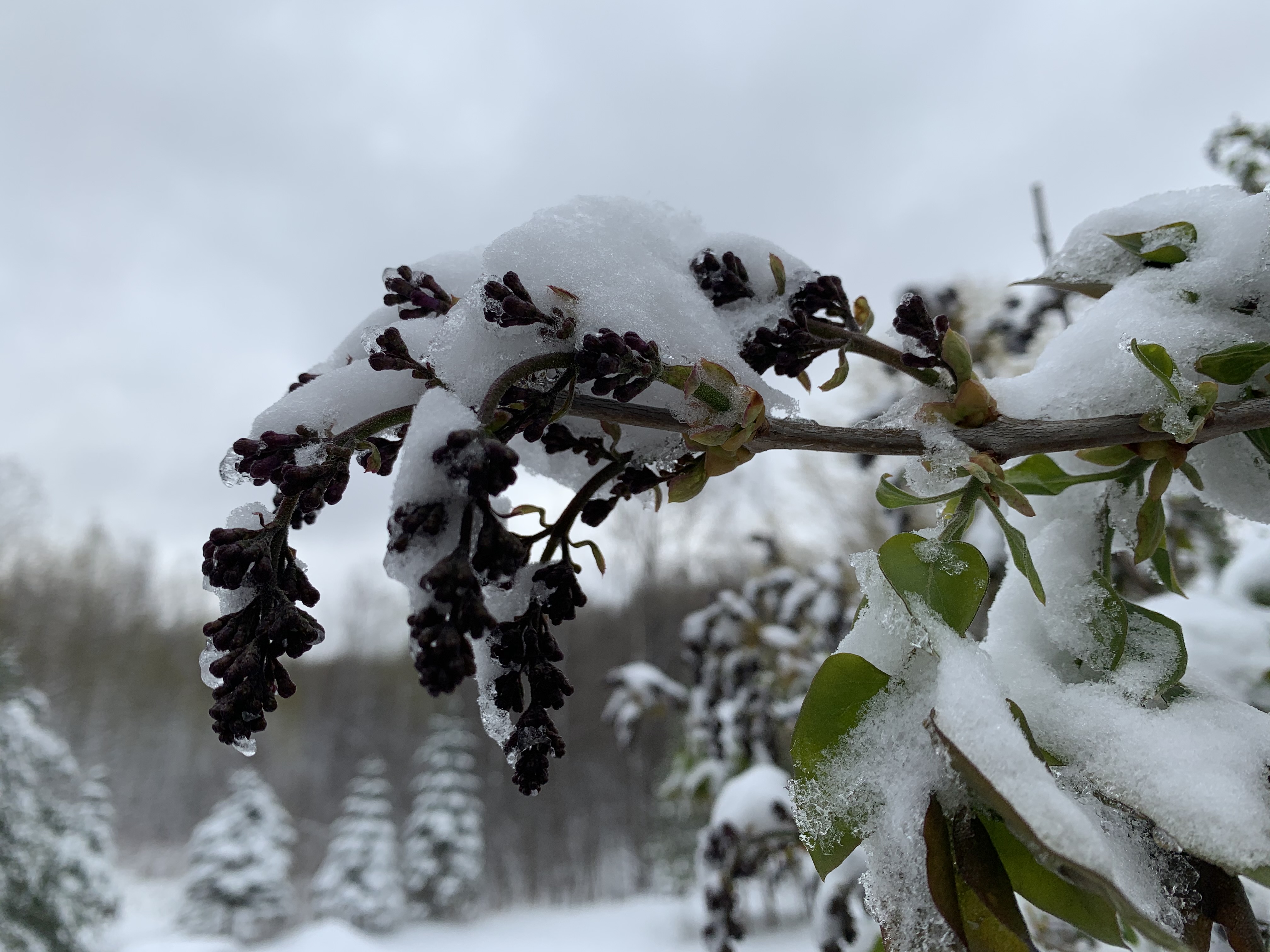
A lilac twig in the rain Thursday in St. Albans, Vermont.
Despite a shift in the forecast towards freezes next week
it's early enough so that most garden plants
should weather the cold just fine. 
 In Thursday morning's post, I remarked about how steady the weather has been in Vermont over the past couple of weeks and how it looks like it might stay that way for awhile. 

Boy, did I jinx things!  

It's beginning to look like we have will have two freezes, one of them perhaps pretty sharp, and maybe some snow as it's looking like we're in for more of a typical April roller coaster. Of course, judging how forecasts have shifted since yesterday chances are they'll shift again.

For now, here's how it looks like it will proceed.

Today will be fine with clouds, some sun and maybe a shower around.  It will be a bit mild for the season - upper 50s to near 60. That's fine. 

The weekend will be breezy, partly cloudy and chilly, but again that relatively normal trend I talked about will hold. Highs will be in the upper 40s to mid 50s depending on where you are, with lows in the low 30s. Again, nothing odd.

By Monday, though, temperatures look like they'll only make it into the 40s with brisk winds continuing. There will be a freeze at night, but nothing terrible for April - mid to upper 20s.

That's the start of the roller coaster. Tuesday looks mild, Wednesday looks showery. Then it looks like we get a cold blast Wednesday night into Friday. 

From this vantage point it looks like we are in for some snow showers even in the valleys during this period. Highs Thursday would struggle into the 40s, maybe staying in the upper 30s in colder spots.  Nights will feature pretty hard freezes, with lows in the 20s. 

It's early enough in the season so that not much will get damaged from the late week freeze. Magnolia blooms will probably wilt and turn a disappointing brown, but most everything else should make it through, unless we're surprised by a much more intense cold snap than forecast.

Apple orchards and vineyards are not far enough along yet to sustain damage from the expected chill.

Probably after next Friday, it will warm right back up again. 

Sunday, March 17, 2024

Another Very Early Spring Risks Expensive U.S. Freeze Damage Later

A freeze last May 18 wilted the leaves that came out
too early in the season on this Williston, Vermont tree.
 Last spring, I took a chance and decided to plant a magnolia tree in my St. Albans, Vermont backyard.

It's supposed to be a rather freeze resistant variety, but you can only do so much. A freeze can spoil the magnolia flower show I'm hoping for.  

It looks like a freeze will do just that. Our insanely warm winter and early spring has resulted in giant buds already on that poor little magnolia tree. 

 If things go the way they almost certainly will, a hard freeze this week will kill off those potential flowers.

The tree will survive, but it won't be as pretty as I'd hoped.

My magnolia drama is just a tiny, tiny example of what farmers, orchardists, vineyard owners and gardeners throughout the eastern half of the nation are fearing. 

That warmest winter on record has been followed by record hot spells in March. Inevitably, the weather pattern has changed, at least temporarily. Normal March weather is hitting many areas, and that means frosts and freezes.  

That's usually not a problem this time of year, but this year is different. Plants are growing way too soon from the Canadian border to the South.   Freeze watches and warnings are in effect for Monday night and Tuesday morning for a large area across the Southeast U.S.  Temperatures in these areas are forecast to fall well into the 20s. 

Even if this cold snap doesn't do much harm, the risk of harsh freezes will last well into April in the South, and far into May for us northerners. 

This could all cause millions, perhaps billions of dollars in crop losses. 

It's become a pattern in recent years. Warm winters led to harsh spring freezes in 2012, 2017, 2023 and other recent years. Each of those episodes caused billions of dollars in crop losses

From apple growers in Michigan to peach farmers in Georgia, farmers are nervously watching the progress of spring cold fronts. It just takes one frigid night, like we had last May 18 in Vermont, to cause immense crop damage.

The fickle finger of climate change is partly responsible for these awful episodes of spring freezes.   Winter is generally the fastest warming season. The dry air of winter is more susceptible to heating up in a changed climate.  So plants grow too soon, turning  spring into a vulnerable season to say the least.

A hallmark of climate change is increased weather variability, so there you go. 

In some cases, the cold snap now moving into the eastern United States is a bit of a blessing. .There's reason to hope the colder weather won't be frigid enough to kill buds. It'll just keep 'em from growing for awhile. 

Michigan apple orchards are already budding, and a week of cold weather will shut down their growth for awhile. That buys time so that the buds will bloom a bit later, possibly helping them miss spring freezes.  

Here in Vermont, the chill expected to last all of next week will stall garden plants and such, so they don't grow big enough to suffer later spring cold snaps (though I suspect my magnolia is a lost cause)

Even if a frost doesn't kill stuff off, the early start to spring threatens other issues.  Plants that emerge too early might not be pollinated by insects, because it's too early for the insects to do their work. 

Pests like mosquitoes will emerge early and last longer, enabling insect-borne diseases to spread more easily. 

In my own yard, based on the behavior I'm seeing, it appears a robin has already laid eggs in a spruce tree in back of the house. That's too early. I have my doubts if those eggs/chicks will survive.

We have no way of knowing right now, of course, whether we will see more ofthose intense spring freezes. We might coast through the season with nothing much in the way of cold fronts.  

Damaging freezes have always been a threat in the spring. Nowadays, the threat has grown. 

Sunday, April 16, 2023

Extreme April Heat In Vermont/New England Might Lead to Crop/Garden/Forest Damage

Earlier than ever. Green leaves were starting to make an
appearance behind my St. Albans, Vermont house this
morning while a lilac bush in the foreground leafs
out and gets ready to bloom. Record heat this past
week as pushed spring into the too-soon category.
When I got up this Sunday morning, some of the early growing trees behind the house shimmered with tender new green leaves. The lilac bushes were brimming with tiny floret buds, ready to put on a show. 

I've never seen that kind of thing happen so early in Vermont.  It's truly remarkable.

This spring had been proceeding at a fairly average, comfortable, pedestrian pace, until the unprecedented early season heat arrived this week. 

Western Vermont won the heat prize Saturday. In Burlington, the record high Saturday was 85 degrees, breaking the old record of 82 set in 2003,

Everything springtime related leapt ahead far ahead of schedule. Things are where they should be around the first of May.  This race through spring will continue today with temperatures that will be far, far above normal again today. 

The summer party ends tomorrow with sharply cooler air.  Long range forecasts are suggesting that the second half of April might actually be chillier than normal.

If this cooler air is just kind of chilly without hard nighttime freezes, that will be good. It will just slow down the progress of spring and start to bring us more in line with where we should be.

Light to moderate freezes, temperatures that stay at or above, say, 28 in the Champlain Valley and in the mid 20s or better in much of the rest of northern Vermont between now and early May probably wouldn't cause much damage. Unless these readings are accompanied a lot of wind. 

 But it can get as low as the teens this time of year in most of the Green Mountain State that would be a disaster.

This coming week won't be a disaster, despite a particular chill in the air Tuesday and Wednesday. At least we'll get a little rain out of this shift to colder weather.  We need it. 

There's a good chance we'll have  widespread frosts and freezes Wednesday night, but I really doubt it will get cold enough to cause any real harm. 

This budding lilac floret, pictured here on April 22, 2021,
froze to death and never bloomed after a late season
snow and freeze that year. This highlights the danger of
what could happen if spring growth comes too soon.

However, if you brought your tender planters outside to enjoy the warmth, you'll need to bring them back indoors this week. 

My hibiscus has enjoyed the warm sun this week, for instance, but I'm locking it in the house and turning up the heat a bit when it gets cold starting this week. 

In the short term, we're safe, but I don't know how cold it might get in late April. 

These strange spring heat waves have already led to sometimes disheartening, or even costly damage.

A record early heat wave in Vermont back in 2002 brought the earliest 90 degree reading on record to Vermont on April 17 the year. Leaves on trees started coming out almost as soon as they are this year. 

Late in the month, hard freeze destroyed garden plants, and blackened swaths of forest by killing the early leaves. The visible damage lasted well into June before new leaves grew.  Trees being forced to re-leaf stresses them, in much the same way that spongy caterpillars did in Vermont last year and the year before,

Trees can usually withstand on year of defoliation, but if it happens year after year, it takes a toll. 

Other times, the damage from weird early heat is not so costly, but just a little depressing. 

Early spring, 2021 was warm and things were blooming early.  On April 21 that year, lilac trees were already displaying budding florets, and crabapple trees were just starting to bloom. 

Then a snowstorm and harsh freeze hit northwestern Vermont.  Some of the crabapple trees never really bloomed that year as a result. Many of the lilacs ended up stunted, only partially blooming.  Living without the annual spring display of full-blown lilacs was surprisingly depressing. 

Climate change has brought too-early heat waves that encourage too-early spring growth frequently in recent years. Sometimes, in the eastern United States, this has brought widespread agricultural damage, as the Southeastern U.S. saw in 2012 and 2017 and to a lesser extent earlier this year. 

That's not to say freezes are guaranteed to ruin our Vermont spring this year. The fact that it has come too early, though, leaves us prone to trouble. The best bet is just to hope for normal late April weather once this heat wave finally dies after today. 

Thursday, April 7, 2022

Loving And Fearing Early Springs: Season Comes Sooner, But Cold Snaps Loom

Although it doesn't look like much yet, one of my
perennial gardens in St. Albans, Vermont is way ahead of
schedule this warm spring. However, these early
bouts of warmth increase the risk of freeze damage later.
So far at least, it's yet another early spring here in northern Vermont. 

Like many recent springs,  things are way ahead of schedule, or at least the schedule as it used to be.  

This week here in northwest Vermont feels and looks like what the third week in April used to look like when I was a kid in the Green Mountain State.

On Wednesday, trees were budding in the sunny, warm breezes. The grass was starting to turn green, perennials in the gardens were up and growing rapidly.  Crocuses bloomed everywhere and some of the early daffodils showed flower buds already. 

The only negative thing was that black flies were starting to bother me a little, weeks ahead of schedule.

Actually that's not the only thing that bothered me about this early spring. The trend, anecdotally around here in Vermont and observed in much of the Northern Hemisphere is this: Climate change is creating early springs. Plants are greening up and blooming earlier than ever, at least in general.

However, brief but intense cold snaps are causing lots of crop and garden damage. And that's not to mention how dispiriting it is to watch your early gardens freeze to death.

Here in Vermont, there's no immediate sign of any looming cold snaps sharp enough to wreck spring, but that doesn't mean it won't happen.

These frigid spells have damaged gardens and such in the two previous premature springs, so chances are it will happen this year, too.

This kind of pattern has already happened elsewhere this spring, and in recent years.    

It had been a warm winter and spring across much of Europe, so plants, crops and fruit trees began blooming prematurely.

Then a blast of winter chill blew in this past weekend. 

They're still assessing the damage, but farmers and agricultural experts know it's extensive. Plum, apricot and cherry orchards in France have been damaged, as has many of its famed vineyards.  

France had its coldest April morning since 1947 with a low of 29.3 degrees. Record lows were also reported in Germany, Spain and Austria.

This is the second year in a row Europe suffered a harsh spring cold wave after a warm winter. 

As the Washington Post notes, last year's cold snap caused $2.4 billion in damage to French wine growers. Some vineyards lost 80 percent of their grapes.

The damage might not be as bad this year, because the cold hit earlier than in April, 2021. Buds and blooms were not as far along as they were during last year's freeze, so that could minimize the destruction. 

Sharp, destructive cold waves during otherwise warm springs seem to be becoming a thing. Says the Washington Post:

"Climate scientists are concerned that warming late winter and early spring temperatures are increasing the frequency of 'false springs' which spur earlier vegetation green-up before the threat has passed of frigid temperatures that can wipe out young, vulnerable plants."

In the Northeast, a cold shot in the final days of March trashed magnolia blooms, wilted some other early flowers and many have caused some orchard damage in parts of the Mid-Atlantic States

The Washington Post has other examples:

"A false spring in March, 2012 was followed by an April freeze that resulted in a half billion dollars in damage in Michigan. A false spring in 2017 and ensuing early April frost resulted in $2 billion in economic damage in the Southeast."

A 2019 study concluded that despite overall warming temperatures, some plant and crop species will paradoxically suffer a trend of increased frost damage due to more premature springs punctuated by quick freezes. 

The problem extends way past plants. Audubon.org notes that earlier, warmer springs prompt birds to migrate northward earlier than they once did. Some species of birds directly freeze to death if they go north, then encounter a sharp freeze.

Or, insects go dormant during the cold snap, so birds that feed on insects suffer or even die. Or, plants that are a food source for our avian friends die in a freeze after a false spring, so that causes issues. 

Audubon.org suggests adding bird feeders and water sources to your property to help the birds through our newly whacky springs.  By the way, animals might come out of hibernation of the late winter is like spring. Then they find out the plants they feed on were wiped out by an April freeze.

Or, blooms on plants like wild apple and various nut species freeze after a premature spell of warm weather, so animals are not able to find enough food during the subsequent autumn.

Then there are us humans.  There's the obvious toll if somebody's vineyard or apple orchard gets trashed by a spring frost after an early bout of record high temperatures. 

At least for me, this pattern of premature springs followed by damaging freezes is dispiriting.  I'm an avid gardener, and the familiar patterns of seasonal changes are important to me. Always have been. I'm a close observer of day to day changes in the natural world around me, and I can spend hours outdoors just marveling at how seasons unfold, especially spring. 

I'm rather neurodiverse, so forgive me for my indulgence there. As my husband always says, I love going outside and playing in the dirt. 

It actually feels soul crushing to watch some perennials die, say in a Mother's Day weekend freeze two years ago.  Last year, a very early spring led to an April 21-22 sharp freeze and snowstorm that destroyed wild apple blossoms near my house, smushed some of my daffodils, and worst of all, largely prevented my lilac bushes from blooming due to frost damage.

Even the joy of this year's early spring is tempered by the inevitable hard freeze I fear will come sometimes within the next month or so.

I realize those freezes were not exactly the end of the world for me, as I suffered no real monetary loss and my gardens ended up looking fine during the summer. But to have the exuberance of an early spring trashed by two days of winter cold is just one more small, but real example how climate change can mess with your mind.  

Sunday, April 18, 2021

Not Just Us: Winter Keeps Trying To Crash Spring's Party

The weather pattern is switching to a chilly, potentially
frosty one for the next two weeks at least, so our early
spring looks like it will go on hold, or worse, actually
suffer some damage. We'll see.
 Most of the last of this past week's snow is melting from New England high country today, as spring tries to battle back from that last wintry setback. 

Despite an early spring over much of the nation, winter in the past few days has increasingly tried to crash the party more and more aggressively.  That state of affairs will continue for the next week at least.  

So while spring will continue to try and assert itself, winter is going to win some last chance battles.  The weather pattern has really switched to a cold one for most of the nation east of the Rockies. 

By the way, those at risk for some stinging, damaging frosts and freezes include us here in Vermont, at least eventually. More on that further down in this post. 

Winter's echo began at the end of last week, as we well know. While we were getting our spring snowstorm in Vermont and the rest of New England, parts of Colorado, Wyoming and Nebraska were dealing with their own winter blast. 

Several thousand people lost power around Denver as several inches of wet snow collapsed some trees and wires.  Like here in New England, Colorado has had some pretty good warm spells this spring, so trees were beginning to leaf out. That's bad when there's snow, as the slush accumulates heavily on the leaves, forcing branches to break.

About seven inches of snow accumulated around Denver. That's not even close to their biggest April snow on record, but it was a set back. Wyoming and Nebraska also dealt with snow and slick roads Friday. 

More snow is likely in the Denver metro area Monday as a colder weather pattern settles into the eastern two thirds of the nation.

Believe it or not, a typhoon way out in the western Pacific Ocean near the Philippines is contributing to this weather pattern.  It was a Category 5 as of this weekend, the strongest you can get. As it heads north, it will help disrupt the weather pattern in a way that makes cold snaps more likely in the eastern and central United States. 

In the northern Plains, where temperatures were at record breaking readings as high as 90 degrees or so earlier this month, the early spring buds have been getting nipped by frost in the past few days. 

On Monday and Tuesday, temperatures are forecast to sink into the teens in North Dakota and 20s in South Dakota. A winter storm warning is up for tonight and Monday in South Dakota's Black Hills for more than six inches of snow. 

There will no doubt be frost and freeze warnings in the central and southern Plains and parts of the Midwest in the coming days. 

Freeze watches are already in effect for Monday night as far down as northern Texas and Oklahoma Monday night.  There could even be a little snow and freezing rain in the Texas Panhandle Monday night. 

VERMONT EFFECTS

For us in Vermont, a series of storms and cold fronts will eventually threaten crops and gardens around here. Possible worst case scenario: You know how the trees are starting to green up?  It could possibly get cold enough to wreck those tender new leaves, meaning trees would have to start over, turning a record early spring into a remarkably late one. 

That bad scenario is not cast in stone and probably isn't even likely, but it could definitely happen in the upcoming weather pattern. It's one that will last awhile, too.

The first cold snap will come later Wednesday and Thursday, but this first one doesn't look frigid enough to cause any damage. A nice rainfall looks likely Wednesday. That's a good thing, because despite all the rain and snow in recent days, we still need more. 

Thursday and to a lesser extent Friday look blustery and chilly in Vermont.  Thursday would feature highs not getting out of the 40s with rain and snow showers. Wednesday night through Friday night would get into the low to mid 30s. Most of us will probably touch the freezing mark, but it won't be cold enough long enough to cause any trouble with plants. 

I'm more worried about a second cold front next Sunday.  At this point, that one looks like it could drive some very chilly air into the North Country. It's way too soon to say exactly how cold it would get, but it's possible we could see temperatures fall well into the 20s at night, possibly near 20.

Normally in late April, such temperatures are not that big a deal, because fruit trees, gardens and decorative flowering shrubs aren't usually far enough along by now to be affected by that kind of weather.   

But the warm spring means everything is as far along as they normally are in mid-May.  If the forecast holds, we could see some real agricultural losses, and a disappointing absence this spring of leaves and flowers.

Some weather models overdo anticipated cold snaps this far in advance and that could well be the case here. So what I outlined above is a worst case scenario.  Chances are it won't be that bad. Time will tell. 

The weather pattern does not look like it will turn warm again for the foreseeable future. Those days upon days of temperatures in the 60s ad 70s we experienced aren't coming back through at least early May, I'm afraid.