Showing posts with label nation. Show all posts

Tuesday, February 25, 2025

After Cold Winter, U.S Finally Gets A Glimpse of Spring; Vermont Only Gets Brief Edges Of It

Despite the vaguely mild weather today, it will be a
while yet until Vermont sees warm spring rain showers
like this one in St. Albans, Vermont, May, 2023.
Spring has sprung -  temporarily at least - in much of the nation following a brutally cold mid-February in many parts of the U.S.  

The warmth interrupted what had been a cold winter in the U.S. while most of the rest of the world stayed warm through the season. 

Some places that were bone chillingly cold suddenly felt like summer. 

As the Washington Post notes, it was 64 degrees Sunday in Aberdeen, South Dakota, breaking the record high of 60 for the date. Just five days earlier, it was 25 below in Aberdeen. 

Buffalo, Wyoming got to 61 degrees Sunday, breaking the old record high for the date by four degrees. 

Temperatures could flirt with 70 degrees as far north as South Dakota today, where rare winter red flag warnings are in effect for fire danger amid dry, windy conditions. 

The warmth in much of the nation comes after a spate of record cold in the middle of the nation and parts of the South last week. 

It looks like much of the central and southeastern United States should stay mostly on the warm side through the first week of March. 

Not so here in Vermont, though. 

VERMONT EFFECTS

In Vermont, we're far from any kind of record highs, but at least it's warmer than it's been. On Monday, the high temperature in Burlington reached 43 degrees.  I know that's not especially warm, but it's still the hottest it's been since January 1. 

If Monday's high of 43 holds for the month, only two Februaries since 2000 had lower high temperatures for the month. 

It's possible it could get even slightly warmer today, given how balmy the overnight was in at least parts of Vermont. It stayed at or above 40 degrees in Burlington continuously from 2 p.m. Monday to 6 a.m. today, when the city finally dipped into the upper 30s. through 6 a.m today.

A chilly rain that will move in this afternoon will probably keep temperatures near 40 degrees, though. 

Historically, we've had lots of years in which January and February temperatures have never gotten past the low 40s. But, in the age of climate change, that's become rare 

Since 2000, only four Januarys had a highest temperature for the month cooler than 2025.  So far at least, there's only been two or three Februarys in the last quarter century with cooler monthly high temperature than this year..

To give you an idea of how warm it can get, today is the anniversary of what I consider the most bonkers February weather day in Vermont history.

The temperature in Burlington on February 25, 2017 soared to 72 degrees, breaking the record for the hottest February temperature on record by an incredible nine degrees. (The previous record high for the month was set two days earlier).

Also on February. 25, 2017, severe evening thunderstorms hit parts of the state an a tornado touched down in western Massachusetts. By just before midnight to complete the day, it was snowing in Burlington.

At least we're not going to go through those extremes in the near future, as we get back to what's going on in the here and now. 

With all the snow we had in the first three weeks of February, Burlington actually pulled ahead of snowfall for the season up to this point in the year.

But now, snowfall is suddenly lacking. For now, anyway. As of today, with no snow in the forecast, today we will slip just under the normal for snowfall up to this date. 

We'll still keep up fairly closely with normal seasonal snow, though. We do have a bit of snow in the forecast as the thaw ends Thursday night and early Friday.   It'll be solidly below freezing all day Friday, and signs point toward maybe a light to perhaps moderate snowfall Saturday 

The frigid air is really planning on rolling in here by Sunday and Monday.  Highs Sunday might not get out of the teens and we could see another excursion into subzero morning lows again Monday.  

Overall, extended forecasts are mixed.  March tend to be all over the place, with blizzards and intense cold one day, and mild sunshine a couple days later.  I have a feeling that's what we'll deal with this March, too.  

Monday, February 17, 2025

American Exceptionalism? Lower 48 Of U.S. Cold While Rest Of World Had A Hot January, 2025

Unlike most of the rest of the world, large
sections of the United States were cooler than
normal in January, 2025 (blue shading)
 Early data suggests the world had a record to near record hot January, 2025, but the United States, at least the Lower 48, didn't join the climate change hot party. 

I'll have another post with more details on global data very soon. But let's look at the United States first, courtesy of NOAA's National Centers for Environmental Information.

As almost all of the rest of the world basked in odd January warmth, it was a remarkably chilly January for the U.S. if you don't count Alaska and Hawaii. It was also incredibly dry. 

THE COLD

It was the 33rd coldest January out of the past 131 years in the Lower 48. It was the coldest January since 1988.

January bucked a trend toward warmer and warmer months thanks to climate change. Despite a warmer world, cold weather patterns can still develop, creating individual months that harken back to a colder time a few decades ago.

I hope you liked the chill of January, 2025, as this type of winter month will keep getting more and more rare. 

No state managed to have one of their top ten coldest Januaries, but nine states had one of their top 20 coldest Januaries. Few states were on the warm side. Only California, Oregon, Washington and Maine were a bit on the mild side. 

Meanwhile, Alaska has its 8th warmest January out of the past 101 years. 

THE DRY

It was sixth driest January on record across the U.S., too, as we really lacked the usual dynamic storms that regularly sweep across the nation in January, 

Seventeen states, including Vermont had one of top 10 driest Januaries this year. (Here in Vermont it was eight driest).  

Most of the U.S. was dry in January too. Anything
in beige or brown was dry on this map. Overall,
the Lower 48 had its sixth driest January on record. 

There were no states that were on the wet side, which is very unusual since in any given month, the nation is usually divided into wet areas and drier ones.  This time, everybody seems to have missed out on the precipitation. 

There were some relatively wet pockets in some states in the northwestern and central Plains, and in northern Florida, but they weren't enough to skew state averages to the wet side. 

About 42 percent of the nation was officially in drought in January, up about 4 percent from the end of 'December. 

This dryness was punctuated by the nation's first weather/climate related disaster of the year. Barely a week into the New Year, the extremely devastating California wildfires began,  At last check, the toll was 29 dead and 16,000 structures destroyed. 

Those fires have finally gone out as southern California has finally entered a somewhat wetter weather pattern. 

It seems does like there's a slight shift in February going on that should make the U.S, relatively warmer and wetter compared to average.  It won't be another January, but it still seems like it might turn out to be a slightly colder than average month for the Lower 48. 

The northern tier of the nation will probably still come out as cold in February, so the nation as a whole   will almost certainly not be among the warmer Februaries we've had. 

Unlike in January,  an active storm track from the the West Coast clear across to the Eastern Seaboard for much of this month will ensure a fairly wet February. Especially compared to January, 


Saturday, February 15, 2025

Storm Has Already Caused Lots Of Problems In The U.S. And It's Getting Worse Today

Huge area under a flood risk today. The orange and 
especially pink area is likely to have catastrophic.
life-threatening flash floods today. 
While we in Vermont gird for our nasty snow/ice/wind storm this weekend, many people coast to coast are either picking up the pieces left behind by the storm, or bracing for some extremely dangerous weather today. 

CALIFORNIA

As expected, the storm first trashed California. 

Dramatic news footage showed a mudslide pushing a fire department SUV through a chain link fence, rolling it down an embankment and landing it in the Pacific Ocean.

Remarkably, after the SUV lands, the firefighter inside got out, waded out of the ocean, up the muddy embankment and hops another chain link fence to safety.  He reported had minor injures.

In Altadena, a security guard in a vehicle was pushed over a drainage embankment. He was able to pull himself to the edge of the water. Firefighters were able to rescue him, and he was taken to the hospital with hypothermia. 

Mud, water and boulder crashes through the city of Sierra Madre Thursday night, trapping cars and damaging homes in the city, the Associated Press reported.

To add insult to injury, a relatively weak tornado hit Oxnard, California, damaging several mobile homes. 

In a bit of good news, the storm pushed a little rain into Las Vegas, Nevada, ending a 214-day streak without precipitation. 

Further north, a series of crashes shut down Interstate 84 in Multnomah Falls, Oregon, about a half hour east of Portland, Thursday as heavy, wind blown snow hit the area. An SUV caught fire in the mayhem, but the occupants escaped. There were reports of four injuries, which is not great, but it could have been a lot worse. 

KENTUCKY FLOOD

A horrible flash flood event is unfolding now in Kentucky and parts of Tennessee, and  forecasters worry it will get much, much worse as the day wears on today. 

A very rare for February weather set up with this wide ranging storm will force torrential showers and thunderstorms over the same area of those two states today. It's bringing a rare "high risk" flood day for a large part of Kentucky and in northwestern Tennessee. 

These areas were soaked by previous storms this month. Today, three to six inches of rain, locally as much an eight inch are in the cards for the high risk area. Meteorologists in Kentucky said even area not normally prone to flooding could go under water with this one.

Widespread flash flood warnings were already in effect across the region as of noon, and the torrential rains are expected to continue the rest of the day. 

The flood risk also extents as far northeast as West Virginia and as far south as Arkansas and Mississippi. 

TORNADOES

In the winter, when a large storm spins off a tornado or two in California, like what happened in Oxnard, a corresponding, much larger tornado outbreak tends to his the southern United States a couple days later.

Sure enough, a large area of severe weather and likely tornadoes is taking shape this afternoon in a large area from Louisiana to Mississippi and on up into Tennessee. Widespread severe thunderstorm winds are inevitable. and numerous tornadoes could spin up between now and tonight. 

It's impossible to tell how many tornadoes will form, but the threat is certainly there.

HIGH WINDS/WINTER WEATHER

The powerful storm system will not only spread high winds through our neck of the woods in Vermont, but across the entire Northeast. Given the dense population, there's sure to be many thousands of  people affected by power outages. 

Those winter storm warnings don't just cover Vermont. They extend through northern New England and into southern Quebec. Winter weather advisories today go as far west as Nebraska. 

Given how widespread this storm is, how many people it's hitting and the varied dangerous weather, this will likely be our second weather/climate billion dollar disaster of the year. The first was those California wildfires. 

A lot of people are going to be happy when this weekend ends, that's for sure. 

 VIDEOS: 

The footage of the fire department SUV being swept by the mudslide and the firefighter self-rescuing. Click on this link to view or if you see the image below click on that. 


News reports that shows footage of a tornado hitting a mobile home community in Oxnard, California on Thursday. Click on this link to view, or if you see image below, click on that.


Thursday, February 13, 2025

Storm To Cause Problems Across U.S. Through The Weekend; Vermont In For A Lot Of....Something

Vermont Agency of Transportation posted
this photo to Facebook Thursday 
showing a backhoe shoving large
snowbanks away from Route 105 in
Jay around Richford Mountain to
make room for more plowed snow
in upcoming storms. 
 Our weird storm from earlier today is mostly done, as the snow we did get settled and got soggy in many places as temperatures went above freezing. 

Nice snowball and snowman making snow for a change, briefly. I saw a couple reports of five inches of snow near the Canadian border in the Northeast Kingdom, which is the most I've seen so far today. 

A few light rain showers in the valleys will change to scattered snow showers this evening without amounting to much. Water on roads and driveways should freeze up this evening, though so take care. 

IT's going to get windy tonight, too, so expect some many areas to see gusts over 40 mph.  The Vermont counties near the Canadian border and in far southern Vermont are under wind advisories, with possible gusts to 55 tonight. 

There might be a power outage or two with that kind of wind, though I'm guessing nothing too widespread. 

After a blustery, cold Friday, we gear up for the long awaiting larger weekend storm. 

First, the big picture

NATIONWIDE DANGER

Our storm is starting to cause its trouble today in California. 

California Flood/Debris

Flooding is possible today anywhere near the entire California coast and in the lower foothills of the Sierra Nevada, below the level where heavy snow is falling.

Southern California is the real trouble zone, thanks to the recent giant wildfires there. Rainfall rates are forecast to be between a half inch to an inch an hour at times, with rainfall totals in the three to six inch range. 

This would be enough to set off some mudslides and flash flooding without the prior wildfires. Now, with the huge burn areas devoid of vegetation and the soil cooked in such a way by the fires that water can't soak in well, the runoff is sure to create large debris flows.  The worry is it will destroy or damage homes that somehow escaped the fire. 

Fire officials have evacuated homes and businesses near the sites of the fires as a precaution. 

Eastern Flood

Once this storm is done with California, its destructive flooding won't end. Forecasters are worried about potentially serious flooding from Louisiana and other areas of the Southeast on up through the Tennessee Valley, West Virginia and southern Ohio,

This area has had a lot of precipitation from the parade of storms that have blown through this region all month.  Rivers are running high, soils and saturated. Now, three to six inches of rain is forecast Saturday in this region, 

There's already a level three "moderate" alert on a four point scale for flooding in this region. It's rare to issue that high a risk a couple days in advance.  NOAA's Weather Prediction Center is considering raising this to a rare "high risk" alert level for flooding. 

High risk is reserved for only the most dangerous flash flood scenarios. (They put Vermont under a high risk alert for the catastrophic flooding on July 10, 2023, for instance).

This could be a deadly and highly destructive flood, and it could hit some of the areas trashed by the extreme floods of Hurricane Helene back in September. 

Severe weather/tornadoes

Forecasters are also worried about a pretty widespread outbreak of severe thunderstorms and tornadoes near the Gulf Coast and Southeast Saturday with this new storm. There were already a handful of tornadoes with the most recent storm yesterday, and this one could prove more widespread. We'll need to watch for updates because of things come together correctly, they could end up with strong, long lasting tornadoes

And of course, along and to the north of this strong storm, freezing rain, sleet and snow will fall in torrents in a wide area stretching from Great Lakes to southeast Canada. Current forecasts call for wide areas of ice in the Ohio Valley, Mid-Atlantic and Northeast. 

Which leads us, finally, to what the hell is going to happen here in Vermont with this storm. 

VERMONT EFFECTS

Disappointingly, we don't know exactly how this will play out. Once again, it's going to be one of those marginal situations between snow, ice and rain

This will be different from all the quick hitters we've had this month. The weekend storm should stick around for awhile. As of this afternoon, it looks like something will be coming out of the sky in Vermont from Saturday evening at least until early Monday morning. 

One depiction of where this weekend's expected
strong storm might be Sunday morning. Exactly
where it goes, and how much warm air
intrusion aloft comes with it will determine
if Vermont gets a lot of snow, or a nasty
mix of frozen stuff. 

The storm itself will also be much stronger than the ones that have blown through here lately. 

At some points in this storm, we're going to have to deal with strong winds in some places. Best guess is early on in the storm, maybe Saturday nigh and early Sunday, strong downslope winds might hit the western slopes of the Green Mountains. 

Behind the storm, we could be dealing with strong, cold northwest winds. 

Like the storm we had Thursday, the temperature profile in different layers of the atmosphere over Vermont will be complicated. 

 We're going to see revisions right up through the storm as to how much snow, how much sleet and freezing rain, and even how much regular rain different parts of Vermont might see.

The early read on this is the main storm will head in from Ohio, across northwest Pennsylvania and into New York and maybe Vermont. A second storm will also start to develop along the New England coast.

How these two systems interact, and how far west the original storm goes, will dictate how much snow we get, versus how much sleet, freezing rain and rain.

There's a still a chance this could remain all or mostly snow, especially in the far north, but we just don't know yet. The best chances of an ugly mix are in southern Vermont.  For the record, the National Weather Service for now is going with mostly or exclusively snow north, and a mix south. 

It does look like it will start as snow for all of us Saturday, with the snow getting heavier later at night. Then we might get the mix, depending on temperatures. The tail end of the storm later Sunday or Sunday night looks like it could provide a decent burst of heavy snow. Maybe. 

I'm not even going to guess on how much snow and/or ice we're going to see out of this.  For now, I'd consider putting travel plans on hold this weekend. Especially on Sunday, when the worst of it looks like it wants to come through. 

This could be the strongest winter storm we've had all season, but what form it will take is ridiculously tricky. 

Tuesday, February 11, 2025

Storms Blasting Across Nation Causing Constant Problems, Vermont Gets Part Of The Action, Too

Early guess at snowfall through Thursday. An inch or less
of this is the snow showers today. The rest is what happens
Wednesday night and Thursday. Forecasters say this
is a really uncertain forecast and subject to change. 
Storm clouds are gathering over America, and for once, I'm not talking about politics. 

That spray of storms blasting west to east across the United States are coming even more fast and furiously than they were last week. 

They're coming with new intensity, and will be causing plenty of varied problems now through the weekend.  And probably beyond.

There's going to be a lot of weather headlines in the next few days. We in Vermont get to participate in this, too. 

More more on that in a minute. First, the big picture.

THE STORM PARADE

It's gotten almost hard to keep track of which storm is doing what, but we'll give it a go. 

One storm has spread winter storm warnings today from Kentucky to Maryland, Delaware and southern New Jersey. 

The storm is spreading an ugly mix of several inches of snow, along with freezing rain along its path.  An ice storm warning is up for parts of West Virginia. Washington DC is expecting three to six inches of snow, with four to eight inches just to the south and west of the nation's capital.

This one should zip off the Mid-Atlantic coast later today. 

Another storm is hot on the heels of that one, but it's going much further to the north than the first. It has already brought winter storm warnings to Kansas, Missouri and Iowa, where five to eight inches of snow is forecast.

The storm will bring rain to some areas of the Mid-Atlantic States and Tennessee Valley that are seeing snow and ice today, so that could bring some flooding problems. Freezing rain is expected again in areas around Pennsylvania that already saw two ice storms last week.

The third and most powerful storm of the series is next up in the queue. The storm is prompting flood concerns up and down the California coast for later this week. They're really worried in areas that had those horrible wildfires in southern California. 

Torrential rains will probably to lead to debris flows in the wildfire zones, as a few inches of rain could fall.

The storm will eventually head east from California, triggering severe weather and possible tornadoes in the South on Saturday.  The storm carries a large area of flood risk this weekend from Louisiana to West Virginia.  This storm will eventually evolve into a nor'easter that will spread snow into the Northeast over the weekend. 

VERMONT EFFECTS

So what does this all mean for us in Vermont? What follows is the breakdown, as best as we can tell now. There's so many moving parts that the confidence in the accuracy of what you're about to read is just so-so. Expect changes to the forecasts, especially for Thursday and the weekend. 

Storm #1, 

The one hitting the Mid-Atlantic and Tennessee Valley today will completely miss us here in Vermont, but that doesn't mean we have a calm day ahead.

A cold front set to arrive this afternoon should set off some snow showers and possible snow squalls, especially across the northern half of the state. The timing is such that they would arrive for the afternoon and evening commute, so it might be a challenge getting home later today - for some of us anyway. 

Accumulations won't amount to much, maybe an inch or two in spots. But sudden changes in road conditions and visibility out on the highways is a recipe for chaos on Interstate 89 and 91. Mostly caused by the minority of drivers who still cannot fathom how to drive in the winter, and thus screwing things up for the rest of us. 

Storm #2

This next one, the one going much further north than the first, will introduce a burst of snow to the region mostly late Wednesday night and Thursday morning. 

The main part of this storm is going by just our northwest, which introduces a twist to our recent snowy regime.

The storm's path will pull in some warm-ish air. The snow that will start light and fluffy will turn heavier and wetter Thursday, then mix with or change to sleet, freezing rain and even rain briefly for many of us.  There's still a lot of questions as to how much schmutz will mix in, and how warm it will get.  Areas west of the Green Mountains will probably briefly rise above freezing. 

An early guess on total snow and ice accumulation is two to four inches, with more in northern New York. But there's a big bust potential with this.  There could be more ice and rain than expected, which could cut down on the totals. Or, less likely, it could stay unexpectedly chilly and keep everything snow.  Stay tuned, I guess on this one. 

Storm #3

Ah yes, the more powerful one, the devil that will cause chaos from California to Canada. We will almost definitely get something out of this in Vermont, but exactly what is a question mark. I've seen forecasts giving us a bullseye of heavy snow, perhaps the biggest of the winter.

Other models take the storm inland, which would mean we get to experience the joy of mixed precipitation again. A few other models take the storm too far south to give northern Vermont much of anything. 

If you have weekend plans, just keep an eye on this one and be ready to adjust those plans if needed. 


Wednesday, February 5, 2025

Vermont Weather Stays Busy With Two Storms As Winter Systems Affect Much Of Nation

My snowy back yard in St. Albans, Vermont glistened in
the late afternoon sun Tuesday after snowfall earlier
in the day. It looks like we're in for at least two more
installments of snow over the next few days. 
 Those atmospheric rivers that have been bringing flooding rains and feet of snow to the Sierra Nevada range in California are having their effects on lots of other people coast to coast, too.  

Those California atmospheric rivers are spinning off one fast moving storm after another. 

 They eventually end up here in New England as quick hitting snow or mixed events, and that's what we will have in storm for a good chunk of this month, apparently.

The latest zipping storm is prompting winter weather advisories and other similar warnings from Kansas to New England. 

Spoiler: Vermont is getting this one, too, but at least we won't have the worst effects of it. 

The big losers, if you will, with this storm would be central and southwestern Pennsylvania, western Maryland and some small sections of West Virginia. Those areas are under a dreaded ice storm warning. 

Those areas tonight can expect a quarter to a half inch of ice accumulation from freezing rain. That'll make travel practically  impossible, and probably be enough to cave in some trees and power lines, so it's a mess down there. 

VERMONT EFFECTS

The quick hitting snow expected Thursday is only expected
to deposit another two to four inches of snow for most
of us in Vermont, with a little glaze of freezing 
drizzle at the end of it later Thursday. 
For us here in Vermont, we get a quick burst of snow midday Thursday .  It might come down pretty hard - as much as inch per hour. 

But the storm's fast motion means it won't last long. It'll probably only really snow for five or six hours from roughly mid morning to mid afternoon, give or take where you are in Vermont.  

Most places will get yet another modest snowfall, generally two to four inches.  

The Green Mountains will probably get a little more than that, especially on southeast facing slopes. Parts of the Champlain Valley might see just under two inches. 

The fast pace of the snow will make roads get ice covered and slick remarkably fast on Thursday. 

The twist on this storm is we're going to get a small taste of that ice in Pennsylvania.  The snow will end as freezing drizzle for a lot of us Thursday afternoon and evening. In Vermont, it'll amount to just a thin glaze, we don't have to worry at all about trees or power lines with this. 

Untreated roads and sidewalks will be a mess, as will the drive home from work Thursday afternoon and evening.  I can imagine the hospital emergency rooms could get busy with people suffering injuries and falls.

Pro tip: If you can get away with it, don't shovel your driveway or sidewalk, and if you're not driving, don't brush the snow off your car tomorrow afternoon after the snow tapers off.   If you shovel, the freezing drizzle would leave a slippery glaze of ice on pavement. If you clear the snow off your car, you'll eventually have to scrape the ice off the windshield.

Wait until the freezing drizzle ends later Thursday night or very early Friday. 

If you don't clear the snow, the freezing drizzle will form a thin crust on top of the snow, but it will still be easier to remove and you won't have to scrape ice or deal with as icy a driveway. 

SUNDAY STORM

After a couple of chilly but quiet days Friday and Saturday, we have another fast moving storm to deal with later Saturday night and Sunday. Though things could still change, the forecasts as of this morning have the storm zipping by just to the south of Vermont. 

It would also carry more moisture with it than what we're getting Thursday. So, there's the potential, anyway, of seeing a good six inches of new snow out of the weekend system. We'll keep you posted. 


Thursday, January 16, 2025

Yes, It'll Be A Nasty Cold Wave, But Far From The Worst It Could Get

Lots of dark blue on the forecast map for this coming
Tuesday, January 21. That means most of the 
Lower 48 is going to be shivering in Arctic air,
but this one won't be nearly as horrible as
some historic past cold waves. 
 A big Arctic outbreak is making its way into the United States and will dominate the weather headlines for a few days.  

It will be brutally frigid, colder than a room full of ex-wives at a wedding. But    this won't be a record breaker, despite the huge area of the nation it's about to hit. 

It follows a general trend in which cold waves are losing some of their punch in the age of climate change. That's not to say we will never see intense, dangerous, record cold again - it's just that it's getting less and less likely.

The Arctic outbreak coming in now would have been considered pretty routine, say in the 1960s or 1970s. 

In this one, temperatures up in parts of North Dakota and northern Minnesota could get into the low minus 30s.  But record lows this time of year, which is on average the coldest part of winter, are in the 40s below.

This cold wave could bring freezing temperatures and perhaps a little snow and ice as far south as Houston, New Orleans, and perhaps Tallahassee, Florida by the middle of next week. The prospect of snow in these areas is pretty uncertain, though. 

It doesn't snow often in these locations but they have had snow in the past. In Texas and surrounding areas, this cold snap won't be nearly as bad as the epic freeze of 2021, during which record cold temperatures and an ill-prepared Texas left the state with a collapsed power grid. The disaster killed nearly 300 people and caused $27 billion in damage. 

Inauguration Day in Washington DC is forecast to be the coldest since 1985, when Ronald Reagan's festivities were forced indoors by wind chills in the teens below zero and actual temperatures in the single numbers.

It won't be quite that bad with Trump's inauguration as temperatures are forecast to be in the mid-20s when he takes office. 

The cold wave will last about a week or less, but linger longest in the Southeast. Afterward, temperatures might not get terribly warm, but they will be more seasonable across most of the nation by next weekend. 

VERMONT EFFECTS

We'll certainly notice the approach and grand entrance of this cold wave in the Green Mountain State, but this won't be one for the record books for us, eithereither. 

Saturday will be warm and windy - very gusty in the Champlain Valley in fact.  Gusts could reach up to 50 mph in the windiest spots which opens up the possibility of a few scattered power outages. Nothing widespread, but something to keep an eye on.

Before temperatures get above freezing, there could be a lot of blowing snow around, too, which would leave us with some spots with poor visibility and sudden slick spots on roads here and there. 

Precipitation with the cold front will be very light, with just a few snow and rain showers here and there. The expected highs Saturday in the 35-40 degree range in the valleys will be the last mini-thaw for awhile. 

Temperatures will drop Sunday, and we'll be in the thick of the cold for a few days. 

There's one interesting little twist to this cold front.  A trailing storm is expected to form in the Southeast and head northeastward.  Originally, it was scheduled to pass too far to the south and east of Vermont to have any effect on us. 

Now, forecasters aren't so sure. It could pass close enough to give us a quick shot of snow late Sunday night and early Monday. It looks like this thing will whip by too quickly to dump a lot of snow, but we could still see some out of this after all.  Not sure on that one yet. 

True to form with 21st century cold snaps in Vermont, this one will be pretty brief, with the worst of it lasting from Sunday night into Wednesday. We haven't had a long lasting bitter cold wave in a long time.

That's not to say we will never again have seemingly endless winter frigid spells, but the truly deep, horrible, long lasting ones almost seem to be a thing of the past. 

Overnight lows in Burlington Sunday night through Wednesday night are currently forecast to each be within a few degrees of 0.  I'm almost sure a couple of those nights will be below zero.  Then the weather will turn seasonable again.

Compare that to January, 1968 in Burlington, when 14 of the first 17 days of the month got below zero, with five consecutive days in the minus 20s.  Or January, 1970, when 24 days were below zero, and all but one day in the ten day period from the 15th through the 24th were at least 11 below.

Or February, 1979, when nine out of the ten days fro the 9th through the 18th were at least 17 below, with the coldest being 30 below.

This winter is proving colder than recent ones, but they're a far cry from past bitter Arctic outbreaks we've had.  

Tuesday, November 5, 2024

National Election Day Weather: Some Trouble Spots, But Mostly Smooth Sailing

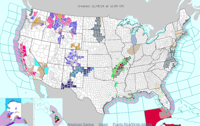
Today's National Weather Service hazards map
doesn't have all that many issues for people heading
to the polls. The red in California is fire hazards.
The green and dark red in Missouri and Arkansas
are floods. Parts of the Rockies are having winter weather.
 As I noted in a post earlier today, here in Vermont it's smooth weather sailing for those going to the polls today. 

In the United States as a whole, there are weather trouble spots, as there always are, but it's mostly not terrible.

The presidential election hinges really on swing states that we've heard about ad nauseum.  Those include Wisconsin, Michigan, Pennsylvania, Nevada, Arizona and maybe Georgia and North Carolina.

None of those states face any really remarkable or terribly hazardous weather today, so I don't think weather will affect turnout there one way or another. Besides, a lot of people in those states have already voted, so they won't even have to step out the door today. 

Michigan and Wisconsin look pretty rainy today, but people should be able to handle that. Western North Carolina is still trying to claw their way back from Hurricane Helene.  Early voting in counties hit hard by the hurricane has been pretty strong, which suggests the disaster won't hurt turnout too much in North Carolina.

It's actually cool for the season in Nevada and Arizona, which is a huge shift from the otherwise hot year they've had so far. So no wilting in 100 degree heat to vote there, thank goodness. 

Most of Pennsylvania looks sunny and warm today so no issues there. 

 There are weather trouble spots today in the United States.

 Parts of Oklahoma, Arkansas and Missouri are still trying to recover from severe weather and flooding yesterday, so I imagine some polling places might be challenged by power outages, blocked roads and damaged neighborhood. 

Quite a bit of flash flooding was going on in parts of Arkansas and Missouri this morning. Parts of Hawaii are dealing with floods, too.

In several spots in the Rocky Mountains, snow and strong winds are messing up travel and making some roads hazardous. 

California, meanwhile, is bracing for a potential outbreak of wildfires today and especially tomorrow.

Overall, though, it's a rather calm Election Day, at least in terms of weather across the United States. Let's hope everything else stays calm.  Stay tuned!

Saturday, November 2, 2024

National Drought Worsens, As We In Vermont Are Getting Drier Too

As of this week, 87 percent of the Lower 48 is abnormally
dry or in drought. That's the most since at least the
year 2000. Only areas in white are not too dry. 
A drought across most of the United States has continued to worsen.  

This week's U.S. Drought Monitor, issued Thursday morning, now shows that 87.16 percent of the Lower 48 United States is abnormally dry or in drought. That's the greatest percentage since this drought monitor started in 2000.

A full 54 percent of the Lower 48 is in drought, which is affecting about 150 million people. 

The reason, of course, was the lack of storminess in October. Preliminary data suggests the Lower 48 might have had its third driest October on record. Only central Florida, which dealt with Hurricane Milton on October 9-10 and northeastern New Mexico, which endured destructive flash flooding on October 19 were notably wet. 

Several cities in the Northeast, South and Midwest had no measurable rain in October. 

Finally, some good rains are in the forecast for a large swath of the nation's middle from northern Texas to the central Great Lakes starting now and continuing for the next few days. 

But of course, given that we always seem to have extremes in this age of climate change, some of the rain is much too much of a good thing. Parts of Oklahoma, Kansas and Missouri appear poised to go from drought to flood in the next few days as five to eight inches of rain are in the forecast. 

I guess a silver lining is that rivers are so low in that region that the inevitable flooding from this storm will not be as bad as it would have if there wasn't a pre-existing drought. 

NORTHEAST 

Wildfire in Monson, Massachusetts on Friday.
Fires are getting worse in the Northeast due to 
a long and getting longer dry spell. 
In the Northeast, which covers the zone from West Virginia and Maryland to Maine, drought and dry conditions expanded quite a bit. That's not surprising given the past week has had little or no rain in the region. 

Last week's report had 64 percent of the region as abnormally dry or in drought. That figure zoomed up to 79 percent this week. Areas in drought went from 29 to 28 percent in that week. 

Most of the Northeast is expecting little rain in the next seven days, with some areas seeing no rain in the forecast at all.  

Wildfires - ongoing for weeks - continued to worse in the region, especially Friday, when dry, gusty winds swept through.  Some were taking on some characteristics of those big western fires we often see on the news.

Eight homes were evacuated in Rockaway Township, New Jersey Friday due to a fast-spreading wildfire. At last report, it looks like firefighters saved those homes. 

During a typical Massachusetts October, about 15 wildfires break out. This October, the state endured at least 200 of them during the month. 

On Friday, a very large forest fire was burning around Monson, Massachusetts and firefighter were working to protect several homes in the area. 

VERMONT 

Most of Vermont is  now considered abnormally dry
due to an ongoing rainfall shortfall. The small orange
areas in far southern Vermont represent drought. 
Here in Vermont, abnormally dryness expanded exponentially. Last week, only southern Vermont was regarded as "abnormally dry." Now, the only areas not considered dry like that are most of the Champlain Valley and parts of the Northeast Kingdom. 

Personally, I'm feeling lucky because as I poke around in the gardens, ground moisture here in St. Albans still looking OK. 

Not exactly sopping wet but so far not much to worry about. I even got a few brief showers that left a few hundredths of an inch of rain Friday afternoon.

Not much, but given the weather pattern, I'll take what we can get. 

Drought in southern Vermont ticked upward a bit, too. It now encompasses about half of Bennington County and a few corners of Windham County.

Rainfall in Vermont is forecast to be pretty paltry, too. Especially in southern Vermont where they need it the most. As of Saturday, the seven day rain forecast had totals ranging from nothing in the southern half of Vermont to maybe a quarter inch at most along the the Canadian border.

We need a lot more rain than that. But long range forecasts keep us dry into mid-November.  

Sunday, May 19, 2024

New Waves Of Storms (And Heat!) In U.S. Will Vermont Be Included In That?

The severe thunderstorm and tornado risk ramps up
again this week for the nation. This map shows the
biggest risk centered on Kansas today.
 The storms keep rolling along in the United States this weekend and the upcoming week.  As if Houston wasn't enough, multiple rounds of severe weather and tornadoes are ramping up again today and should continue most of the week. 

And, since we're getting closer to summer, dangerous heat is beginning to make inroads, too. 

I'll have a separate update on the Houston mess, so we can get right into the forecast. A Vermont update is further down, after we do the big picture. Spoiler for Vermonters: We hope you like summer. 

TODAY

One always important ingredient for big thunderstorms is heat and humidity, and that will be a thread through this week's storm risk. 

Way down in the South, the heat is horrendous. Miami had a heat index of 112 degrees yesterday, by far the worst on record for May in that neck of the woods. 

Parts of Texas will roast in 100 degree heat today. 

Some of that heat is feeding north toward a storm organizing somewhere near western Nebraska. Some of that heat is heading north toward Kansas, where it will encounter the effects of that storm. The result is an expected outbreak of intense storms. 

NOAA's Storm Prediction Center has put central Kansas under a moderate risk of severe weather today. That's the second highest in a five point alert scale, meaning this is pretty serious. The biggest risk is straight line winds which could reach hurricane force in some areas along with giant hail. 

Tornadoes are also pretty likely, but I question whether it will be a big outbreak like Kansas, Nebraska and Iowa suffered in late April. 

Tomorrow's severe threat once again focuses on Kansas and Nebraska, so they're not out of the woods yet.

An even bigger and more widespread severe weather outbreak seems likely Tuesday as heat and humidity continues to stream into the eastern half of the U.S.  It'll interact with storminess coming in from the west to set off a big severe zone from Oklahoma to Michigan.

So far, it looks like Missouri and Iowa might take the brunt of things on Tuesday, but of course the forecast might also be adjusted. 

Severe storms and tornadoes are likely to continue in different parts of the Plains, Midwest and east Wednesday, Thursday and probably beyond that, too. 

The preliminary tornado count for this year is 820, which is pretty pretty far above normal for this point in the spring, and it looks like we will add to that list of twisters in the coming days. 

VERMONT EFFECTS

Lilac season is in full swing in Vermont now, but it
will probably go by really fast due to hot, humid
weather for the season this week. There's
  a chance of severe storms this week, too, but 
things will have to line up just right for that to happen.
So far in 2024, Vermont is one of only three states to have not reported any severe thunderstorm winds, damaging hail or tornadoes. (New Hampshire and Maine are the other two states).

There might - or might not - have been local wind damage from isolated strong storms last week in Vermont, but there have been no reports from the public, so the count is zero. 

That might change this week, as we have some chances of severe weather. But whether or not that actually happens depends. Things need to come together just right to do that. 

As noted, heat and humidity are a key ingredient for strong storms. We're pretty confident it will be hot and humid for the season this week.  Temperatures should get into the 80s Monday through Wednesday, and maybe into Thursday. The humidity will gradually creep up, too. It might actually get to 90 in a couple spots Wednesday. 

The question is whether the oppressive weather for this time of year will touch off anything major. 

A weak disturbance on Tuesday has a shot at interacting with the summer warmth to set off some storms. If that happens, one or two might be briefly strong to severe. It's impossible to know exactly where this might occur, but if it does, it's more likely in northern Vermont. 

As it looks now, Wednesday looks quiet and hot, but just the fact it will be so summery could yield some mountain updrafts that generate local storms. Probably nothing widespread, but one or two places could get blasted by a torrential downpour and gusty winds.

The wild card is Thursday. A cold front will be coming in by then. If it passes through in the morning, the chances of severe weather are low. If it comes through in the afternoon or evening, that will give the atmosphere a chance to become much more unstable. Then, thunderstorms would have an opportunity to become strong to severe. Stay tuned! 

By Friday, the air will have become much cooler and drier, which would prevent any further big thunderstorms. 


Tuesday, April 16, 2024

As If You Need Confirmation, Spring Has Arrived In Vermont. And It's Early

 You see the daffodils and the crocuses, the greening grass and the buds on the trees. 

Areas shaded in red are where early plants like 
honeysuckle and lilac have started to leaf out. The red
means spring is arriving much earlier than normal
this year. As you can see, it's gotten into Vermont
as of this morning, though the mountains and
Northeast Kingdom are still waiting on this.
Spring seems to have arrived in Vermont. 

But if you need the official word on the precise arrival of spring, the National Phenology Network is here for your service. 

As I've written before, this organization has what is know as the first spring leaf index.  It indicates when particularly early species - specifically honeysuckle and lilac - start to sprout leaves.

And, as of today, these plants have started to leaf out in the Champlain Valley low elevations in southwestern Vermont and parts of the Lower Connecticut River valley.  Those leaves haven't quite appeared yet in the Green Mountains, north central and northeast Vermont. 

  By the National Phenology Network's (USNPN) estimation via the spring leaf index, the season is as much as  two weeks earlier than the long term average here in Vermont.  

Despite two spring snowstorm and temperatures that have only on a few occasional broken past 60 degrees, it's been pretty consistently warmer than average in Vermont all year, including in March and so far in April. 

Which has kept spring ahead of schedule around here.  On average, according the Network, a spring this early happens once in every four or five years, give or take. 

It's not just us.  Spring has been way ahead of schedule for most of the nation east of the Plains. According to USNPN

"The Sacramento Valley. coastal areas of northern California, Oregon, and Washington, and parts of the Great Plains and southern Midwest are seeing the earliest spring leaf out on record."

The exceptions to the early spring trend are in southern Texas and Florida where early spring leaf out hits in late winter.  It was a little cool down there at that point so they were slightly late

Of course, those far southern areas are now in full summer leaf.  

Over the next several days, temperatures across Vermont are forecast to be more or less near normal for this time of year. (Highs in the 50s, give or take, lows near or somewhat above freezing).

That means spring will continue to advance, but probably at a gradual pace. The Northern Vermont away from Lake Champlain might end up having an early spring, by USNPN standards, but maybe not quite as early as the banana belt of Vermont. 

This early spring obviously doesn't mean you can put out your tomatoes just yet. We have more frost to get through yet. Maybe even snow, who knows?

It's greening up out there, and it's nice to now see another color in the outdoor spectrum other than brown and gray.  I can get used to the increasing greenery out there. 

Wednesday, February 28, 2024

Record Warmth And Temperature Clash Caused Danger, Storms, Weirdness Across Much Of Nation

Screenshot of video taken through windshield as the
vehicle drove over a bridge with the Texas
wildfire beneath it. 
It's obviously not just Vermont going through strange weather, record highs, storminess and temperature swings. 

Other parts of the nation are getting either blasted or weirded out, too.   

TEXAS FIRES

Probably the most dangerous situation is in north Texas, where wildfires spun way out of control Tuesday amid rock bottom humidity and winds gusting to 70 mph.

 It didn't help that a cold front abruptly shifted the strong winds from the west to the north, making the fires especially erratic. 

One of the fires is the second largest in Texas history.  It's about half the size of Rhode Island and growing. That same fire also spread into Oklahoma and was 0 percent contained as of early this morning. 

The fires sent people fleeing from a series of rural towns and ranches north of Amarillo. 

Though details are still sketchy, the town of Fritch, population 2,000 appears to be hard hit, with an unknown number of homes lost, says the Associated Press. At one point, the city of Borger, population 13,000 was entirely surrounded by fire, so people couldn't flee. 

Several homes in the town of Canadian also burned, according to CNN.

Firefighting efforts and a wind shift kept most of the fire outside of Borger.

The wind has lightened up and cooler weather has arrived. There might even be a small amount of rain and snow Thursday. But dangerous fire conditions are forecast to return next week.  

MIDWEST TORNADOES

At least 13 tornadoes hit parts of northern Illinois, Ohio and Michigan yesterday and last night. That's very far north for tornadoes this time of year, especially that many. 

In late February, there is often an uptick in tornadoes, but those almost always occur in the Southeast during the last winter.  

Screenshot of tornado damage in Michigan this morning. 

In the Midwest, there were several reports of damage, but no serious injuries. Chicago's O'Hare airport was briefly under a tornado warning, but it appears no twisters touched down there. 

A few severe thunderstorms are possible today and this evening in a broad stripe along the Appalachians from Alabama to Vermont, but no additional tornadoes are forecast. 

TEMPERATURE WEIRDNESS

The cold front causing the severe weather and worsening the wildfires also caused lots of strange temperatures changes. 

Yankton, South Dakota was sunny and 70 degrees at 4 p.m. Monday. Exactly 24 hours later, it was 13 degrees and snowing. 

St. Louis reached 86 degrees on Tuesday, its hottest February day on record. Just 15 hours later, it was 60 degrees colder, at just 26 degrees. 

On Monday, Rockford, Illinois reached 73 degrees, breaking the record high for the entire month of February and for meteorological winter, which runs from December 1 through February 29.  That record lasted only one day, as Rockford reached  78 degrees Tuesday, incredible for that far north.

By 7 a.m. today, Rockford was down to 19 degrees with a north wind gusting to 51 mph and a wind chill of 2 above. 

It looks like at least 120 weather stations in the United States had their all time hottest February day over this past week. 

Record warmth hit parts of Canada, too. Ormstown, Quebec, about 50 miles northwest of Alburgh, Vermont,  reached 69 degrees, the hottest February temperature on record in the entire province of Quebec. 

Several cities in Ontario also had their hottest February day on record. The same cold front making temperatures crash in the United States is also hitting Canada. This morning, Sudbury, Ontario went from 41 degrees to 14 in an hour. 

SIERRA BLIZZARD 

A separate storm is set to cause one of the worst blizzards of the 21st century in the Sierra Nevada mountains. 

Between Thursday morning and Sunday morning, lower elevations near Lake Tahoe can expect two to four feet of snow with winds gusting to 60 mph. A little higher up, snow totals are expected to reach four to eight feet with winds gusting to 100 mph. 

Forecasters warn that travel will become virtually impossible for days, that stuck cars could end up being entirely buried in snow. Whiteout conditions will quickly disorient anyone out on foot. So it's a dangerous storm. 

One of the few bright sides to this storm is that total snow cover is lagging a little bit in the Sierra, and this will help them catch up. 

Tuesday, January 23, 2024

Firehose Of Moisture Off Gulf Of Mexico Creating Widespread Weather Problems, Including Vermont

There isn't all that much snow in the forecast tonight
and tomorrow in Vermont but........
 We've got an interesting, kind of weird weather set up for much of the U.S. today.  

By interesting, I obviously mean unpleasant for many.  We in Vermont are going to participate in that unpleasantness this week. More on that down below, but first the odd weather setup:

FIRE HOSE 

 A disturbance that contributed to a lot of flooding in San Diego yesterday is re-invigorating a flow of wet air off the Gulf of Mexico.

The moisture has already caused problems. Freezing rain coated places like Arkansas and Missouri Monday, causing tons of highway and road crashed. This includes dramatic video of a fire truck spinning out of control down a hill in Missouri.

That disturbance that came in from California is going to turn that flow of wet air off the Gulf of Mexico into a fire hose starting today. This will set off a lot of flooding over the next couple of days in Texas, Louisiana and Mississippi, and possibly surrounding areas.

Like water from a fire hose, the bulk of the flow will not reach much longer distance, but some of the "spray" if you will should make it to the Canadian border and a little beyond.

Low level moisture from this is creating a weird, huge area of locally dense fog from the southern tip of Texas all the way north to Montana. There's very little rain, ice or snow in this immense fog bank, but it's still odd.

The precipitation from the fire hose is mostly heading northeastward from the lower Mississippi Valley. It' is covering or will cover an area through the Mid-Mississippi Valley, Ohio Valley, southern Great Lakes and on into New England 

Lingering cold air near the Earth's surface from that departing cold snap is prompting winter weather advisories for freezing rain from Missouri to here in Vermont. 

Such a huge area of freezing rain, combined with what happened in Missouri and Arkansas yesterday, is really going to pile up the wrecked cars and trucks from all the highway crashes its contributing to.   Between the expected flooding in the Deep South and the ice elsewhere. It's quite a mess. 

VERMONT EFFECTS

It barely got above freezing in parts of Vermont this morning for the first time January 14. That marks the longest stretch of winter weather in the Green Mountain State so far this season, but that's not sayin much. (The longest stretch of continuously below freezing temperatures in Burlington is 51 days in the winter of 1976-77).  

.......freezing rain will cover most of Vermont
Wednesday night, with the most in eastern parts
of the state. Ugly travel Wednesday night and
early Thursday on Vermont roads. 

The above freezing air this morning is short lived as a cold front passes through from Canada today, so temperatures will slowly fall.

The cold high pressure will set up residence in southern Quebec and northern Maine, and that is an important ingredient in our upcoming weather woes.

The first bit of "spray" from that Gulf of Mexico fire hose will make it here tonight. 

The first round of precipitation will pretty much be all snow, and it won't be that bad, really.  Most of us should see one to three inches of new snow by tomorrow morning. 

Then the real trouble begins Wednesday night.  Another surge of moisture will come in Wednesday night into Thursday. By then, the flow of southwesterly winds aloft will warm the atmosphere several thousand feet overhead to above freezing.

Meanwhile, that cold high pressure will feed chilly Canadian air southward near the surface. The result: A round of ugly freezing rain. 

This won't be one of the those rare storms that take down a bunch of trees and power lines.  Maybe there will be an isolated power outage or two but nothing widespread. It won't rain hard enough for that much ice to accumulate. Thank goodness, because we've had enough downed trees and power lines this winter, haven't we?  

But it will be enough to make the roads a mess.  The most likely areas to see freezing rain is almost everybody east of the Green Mountains. The far northern Champlain Valley, mostly north of Milton and South Hero seem destined to see ice, too. 

The forecast is of course tricky, so ice could end up being more widespread or less widespread than I'm describing here. 

Also, it's been cold recently. So even places that get or stay a little above 32 degrees will see rain freeze on impact on cold back roads, dirt roads, driveways and sidewalks. So we'll have to look out for that.

By Thursday afternoon, it looks like most of us will transition to a cold, non-freezing rain (with still that risk of ice on cold surfaces).  Occasional rain and thawing will continue well into Friday, as it looks now.

A winter weather advisory is up for Vermont from tonight all the way to Thursday morning. 

This will be light precipitation, so I'm not worried about flooding later this week. But this is another long lasting bout of crappy weather.    Honestly, it's been that kind of winter. We'll have just a slight risk of snow showers today. But starting tonight, it will be doing something off and on through Friday. Another endless stretch of gloom indeed.


Sunday, January 14, 2024

Sunday In Vermont: Snow Squalls Are Today's Hazard, But Unlike Rest Of U.S. Wet Get Break From Extreme Weather

A snow squall approaching St. Albans, Vermont in
February 2022 looked like a wall of snow
approaching. Similar scenes are possibly today
in parts of Vermont. 
 In the "It's always something" department, Vermont has one more hazardous day to get through today with the weather. 

The danger today will be out on the roads.

One cold front has come through. It's breezy and chillier, with snow showers around. Nothing wild .A second cold front is coming through Vermont today, and that looks like it has enough oomph to set off some snow squalls. 

Snow squall warnings were already in effect for parts of Pennsylvania this morning. 

There's a decent chance parts of Vermont might go under such warnings late this morning and afternoon. The snow squalls can be quite powerful. There's a low but not zero chance that some of the squalls today could create lightning and relatively rare thundersnow in parts of the Green Mountain State.

Snow squalls are dangerous because they abruptly turn visibility on the roads from just fine to zero. Road conditions also go from just fine to awful. That's a recipe for highway crashes. Some of the worst pileups on U.S. Interstate highways have been in snow squalls. 

If you're out driving today and go you hear a snow squall warning, and if you can, just find a way to get off the Interstate or busy highway and wait it out. Snow squalls rarely last longer than a half hour. Of course the roads will be iffy after the squall passes, but at least you won't be driving blind.

Or better yet, just stay home today. 

A February, 2022 snow squall in St. Albans,
Vermont cuts visibility to near zero. About 20 seconds
before this photo was taken, visibility was fine,
showing how quickly snow squalls can change things.

These squalls won't cause a huge amount of accumulation - probably a half inch to three inches at most. 

Another interesting thing going on this morning is that one of those lake effect snow bands coming off Lake Ontario is so powerful that it made it all the way into far northern Vermont and to the southeastern corner of Quebec.

Here in St. Albans, I caught the edge of it briefly and got one inch of snow. The snow band has since moved north. 

EXTREME WEATHER

That powerful snow squall from Lake Ontario I mentioned is part of a continuation of the extreme weather much of the United States s either dealing with or picking up the pieces in the aftermath.

Vermont is more in the picking up the pieces mode than bracing for extreme weather. The real bad stuff appears like it wants to give Vermont a break for awhile. 

As of 8:30 a.m. Sunday, about 3,000 homes and businesses were without power in Vermont, mostly in Rutland County.  Perhaps the most dramatic instance of damage yesterday came in Richmond, where the metal roof of a house blew off.

Neighbors swarmed the house during the day and pretty much replaced it by nightfall for the elderly woman living there, WPTZ reported. 

Video of the strong winds near Richmond, Vermont is at the bottom of this post.

Although today will be gusty, we won't have any winds strong enough to cause further damage. 

Saturday's storm was far more destructive in New Hampshire and Maine. Serious flooding hit Hampton Beach, New Hampshire for the second time in a week, and structures were destroyed by pounding waves and high tides in Maine. 

Blasts of Arctic air - belatedly the first real cold outbreak of the winter - is causing the continued extreme conditions this week. But not really here in Vermont

The frigid air is taking what the I, and the National Weather Service office in South Burlington call the "scenic route."  

Radar from the National Weather Service office
in South Burlington this morning shows a lake
effect snow band extending all the way from
Lake Ontario across northwest Vermont and 
southern Quebec.

It plunged southward into Montana and North Dakota, and kept going south and east, freezing the southern United States - or is about to.  

One cold blast has already hit, dropping temperatures into the 40s below zero in Montana and siccing a blizzard in the Midwest. 

Then that cold air heads northeastward from the Midwest towards us. This indirect route gives the Arctic air a chance to warm up a little bit. By the time it gets here, we end up being kinda cold, but not OH MY GOD awful.

This arrangement is also helping to create strong west to southwest winds off of Lakes Erie and Ontario, which is why western New York is getting slammed by those lake effect storms. 

The path of the cold air seems to want to suppress storms to our south this week. One on Tuesday will go out to sea well south of Vermont, but a separate system will give us light snow that day.

Another storm Friday could hit us, but early indications are that one, too will go out to sea.

Meanwhile, those storms will unleash cold, snow and ice on parts of the South this week. 

Back here in Vermont, the coldest weather looks like it will arrive by next weekend, and we might see our first subzero cold on the winter. A very late start to that idea.

The cold across the nation looks like it will be rather short-lived, too.  A warmup is about to start in the Rockies, and that should slowly move eastward across the U.S. reaching us here in New England in perhaps seven or eight days. 

VIDEO

Strong winds sweep through the Jonesville section of Richmond, Vermont Saturday.  The downslope winds can erode clouds near the mountain slopes where they originate. It happened during this storm, creating a rainbow amid the chaos. Click on this link to view, or if you see the image below, click on that.