Showing posts with label winter weather. Show all posts

Tuesday, December 2, 2025

Snowstorm In Vermont Ending This Evening, Snow On Ground To Remain For Long Time

Vermont State Police posted this photo to Facebook
today. It was one of dozens of crashes they've dealt
with amid our day-long snowstorm. Roads remain
iffy through this evening, and probably 
into tomorrow morning. 
A few last narrow bands of fairly heavy snow were moving through Vermont as of 5 p.m. today, which will be the last harrah of our snowstorm. 

I see that there has been widespread four to five inches snow reports as of late this afternoon across Vermont. 

My place in St. Albans is lagging behind with 2.9 inches, as the drier air coming in from the northwest made an early appearance midafternoon. Burlington had 3.7 inches of snow as of 4:30 p.m. 

The snow had really tapered off by around 3:30 or so in most of northwest Vermont, which raised hopes of an easier commute this evening. But radar shows a final burst of moderate snow moving in, which is complicating the trip home. 

A more substantial band of heavier snow was extending across southern Vermont, running from Bennington County and going up toward White River Junction.

This area of somewhat heavier snow will probably help ensure the southeast half of Vermont will get the five to 10 inches of snow that had been forecast. 

This snow will keep the roads crappy for awhile yet.  As we mentioned early this afternoon, there had already been a bunch of wrecks. Vermont State Police provided the following update at around 4 p.m. today:

"Troopers have been busy keeping up with crashes, responding to 27 weather-related wrecks in the northern half of Vermont and 23 in the souther half from midnight to 2 p.m. Tuesday. Of the crashes, 17 took places on interstate highways, one with a reported injury, and 33 occurred on secondary roads, three with injuries."

I guarantee additional crashes this evening, unfortunately. Keep it slow and steady out there on the roads, folks. 

WHAT'S NEXT

Going forward through this evening, the remains snow that is falling in the northwest half of Vermont will quickly come to an end, shutting down northwest to southeast like we've been anticipating. It'll take longer to stop snowing in southeast Vermont. 

The northwest half of the state should be done with this between 6 to 8 p.m. or so. Central Vermont might have to wait until as late as 9 p.m. or so to see the snow stop. Southeastern Vermont will keep it going until around 11 p.m., give or take.

When you get up to go to work or school early tomorrow, you'll unfortunately still need to be a little careful on the roads. Yeah, I'm already sick of it, too. .It won't be snowing, but with temperatures falling into the teens to around 20, things will have frozen up pretty well. .

Be especially careful on bridges and overpasses. The ground is still kind of warm. That, and road salt, might make the overall road conditions not too bad. But the bridges won't have the benefit of the warm-ish ground underneath, so they'll have some black ice. Zipping along at 60 to 70 mph and then hitting the black ice at the bridges is not fun, let me tell you. 

Under partly sunny, chilly skies, the snow cleanup should finish up pretty well, even on the back roads. It'll be a fantastic day for winter sports statewide. 

THURSDAY TROUBLE

The next problem comes Thursday, with that Arctic cold front we've been talking about. That front still looks like it will come through during the morning, maybe early afternoon in southeastern Vermont. 

It should have a band of snow showers and snow squalls with it. That band of potential squalls could dump a quick inch of snow in a half hour to an hour. That means horrible visibility on the roads, which will quickly ice over.

Then, during the day, temperatures will crash amid frigid northwest gusts to over 30 mph. Look out for blowing snow, and keep your thickest winter coats ready, as wind chills will sink well below zero why nightfall.

Temperatures overnight will drop to within a few degrees either side of zero. That kind of weather is a bit earlier than usual in the season. Not record breaking, but still. 

The sharp contrast between the still relatively warm waters of Lake Champlain and the frigid air might create a few cold air funnels over the lake Thursday night and Friday. If you can brave the cold, you might want to get up very early Friday and check it out if you live nearby. 

It'll stay colder than we're used to at least into mid-month. 

I won't have a full report early tomorrow morning on the storm because I've got some appointments to take care of.  But I will do that later in the day and provide any update to the frigid weather that's going to blast down on us. 

Tuesday, April 1, 2025

Yes, More Vermont Winter Weather On The Way

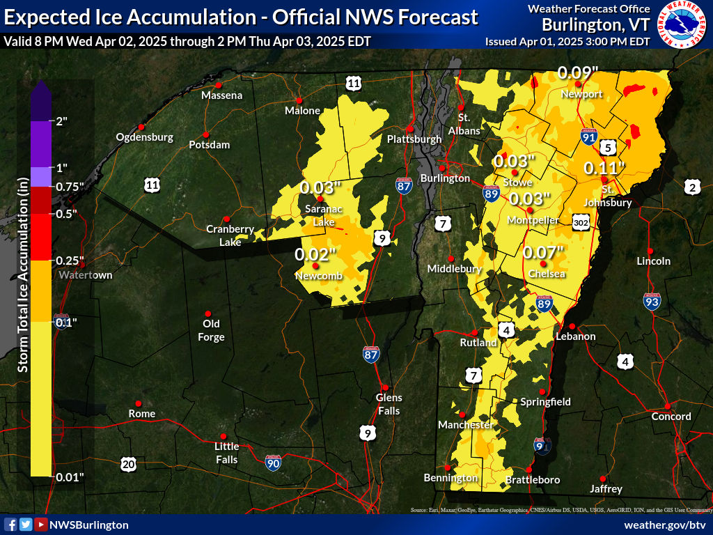
Yep! Another ice forecast map from the National Weather
Service office in South Burlington. This time, at least
the ice shouldn't be thick enough to cause more than a
few widely scattered power outages in the NEK
 Just a quick update this evening to acknowledge that yes, there's another winter weather advisory up for parts of Vermont. 

I'll keep it brief this evening. 

That new storm will swing a batch of snow into most of Vermont Wednesday evening. That will quickly go over the freezing rain again overnight. 

In most of southern Vermont and the Champlain Valley, the freezing rain won't last all that long as temperatures overnight keep warming up. The freezing rain might not even materialize in some spots in the Champlain Valley. 

The Northeast Kingdom will hold on to the cold air, though, so the freezing rain could keep going all night and into early Thursday. At the very least the roads up that way will be nasty in many spots overnight Wednesday and for the early morning commute. 

The worst hit places could accumulate up to a quarter inch of ice. That might set off some isolated tree damage and widely scattered power outages, but nothing like parts of central and southern Vermont endured over the weekend. 

Everybody will be in the rain Thursday, though that rain will be tapering off through the morning. It will be another warm day, kind of like how Monday quickly warmed up.

This storm is looking pretty windy, too.  So far there's no wind advisories up, but it could get pretty gusty overnight Wednesday.  Forecasters are watching for the possibility of even strong southwest to west winds Thursday afternoon. That's when you might see possible wind advisories popping up. 

The storm, though on the strong side, is moving fast, so it won't have a chance to dump a ridiculous amount of precipitation on us. Rainfall won't be enough to cause any flooding issues. 

Unlike last night, there won't be an immediate rush of cold air behind the storm. Friday actually looks nice and springlike. There will be at least some sun and temperatures should reach the 50s. 

The upcoming weekend looks rainy, with a slight chance of - UGH - maybe a little ice in some spots. 

I'll have much more on this tomorrow morning, but there's your update for now.

Monday, March 31, 2025

One Last Round Of Rain With Our Vermont Storm As We Get Ready For Yet Another One

The Killington, Vermont Police Department posted
this photo of a downed utility pole and wires blocking
a road in the resort town after Sunday's ice storm. 
Today's Day 3 of our long Vermont storm that really started Friday night. 

The great news is today will be the easiest of the three days by far.  

We're still suffering the hangover from Sunday's ice. 

All night and into early this morning, the number of homes and businesses still without electricity in Vermont stayed stubbornly above 5,000, after peaking art around 10,000 yesterday. 

Bottom line: Today's not a perfect weather day of course, but those are kind of rare this time of year anyway. 

Temperatures are warming up, and we should make it into the 60s today for a brief break from our wintry mess.  

The remaining snow and ice from the weekend should disappear for most of us pretty quickly today, it it hasn't already. Here in St. Albans, we had about six inches of new snow Saturday morning. Less than 48 hours, when I got up this morning and looked out the window, you'd never we ever had any snow. 

There is a few changes to the forecast. For most of us, the expected line of showers should come through Vermont in the morning and early afternoon, though there might be some showers behind that line.  

Earlier, we thought the bulk of the showers would be later this afternoon, but things have sped up a bit. 

Our showers might be briefly heavy with a slight chance you'll hear a rumble of thunder or two. But any heavy rain won't last long in any one place.  

We should have a half inch or less of rain today. Between the lingering rain and the snow and ice melt, the rivers should rise, as we've been saying all along. But if any flooding happens, it will be minor. 

QUICK WINTER RETURN

What had been six inches of snow was seen rapidly
melting off my St. Albans, Vermont driveway 
Sunday afternoon as temperatures rose above 
freezing and rain continued. 
If you thought we were done with winter weather after this past weekend, think again.  First of all, our current storm's cold front will drop us below freezing by Tuesday morning, and most of us won't even make it to 40 degrees Tuesday afternoon. 

By Wednesday morning, most of us will be in the teens, and there could be some single number temperatures in the cold hollows.

Following that is our next storm. With the cold air lingering at first, another round of snow, sleet and freezing rain (sigh!) seems likely Wednesday night. 

The snow probably won't amount to much.  The freezing rain won't accumulate nearly as much ice as the last storm did, so we won't face power outages and tree damage again. 

But, if you're on the roads Wednesday night, you'll probably encounter crappy driving conditions. Things should go over to rain Thursday as we get another squirt of mild air. 

At least the next storm's effects won't be nearly as bad in Vermont as in other places. This next storm is forecast to produce another large severe storm and tornado outbreak in the Midwest and Southeast. 

This storm, and a weather front associated with this storm that is expected to stall, looks like it might cause another round of serious flooding in parts of Kentucky, Tennessee, Missouri and Arkansas.

Back here in Vermont, don't count on winter ending even after we get through Wednesday night's schmutz. Signs are pointing toward a week long spell of wintry cold and maybe occasional snow starting in about seven days from now. 

Those long range forecasts aren't always right, but the ones I've been seeing have been pretty consistent, so there's that.  

Monday, January 20, 2025

Nor'easter Zips Away, Leaving New England To Deal With Cold Winter Winds

The snow was over and the sun was out early this 
morning in Vermont. But it's cold, so it's hard to 
get all the snow and slush off the roads. Salt isn't
working great. This is Route 100 in Ludlow 
around 8 a.m. today on a traffic cam grab.
 Our nor'easter from last night, true to form zipped on past and is pretty much out of our hair as of this morning. 

It pretty much played out as expected, though there were a few twists and minor surprises involved with it. 

Once it got its act together, the storm seemed even a little more dynamic than I might have expected. It provided northeast New Jersey and the New York City area the spectacle of thunder snow, which is always fun. 

Apparently the extra oomph the storm had allowed it to overcome the dry Arctic air flooding in from the northwest. 

Which meant even the northern Champlain Valley managed to see a little fluffy snow.  Here at my place in St. Albans, Vermont, I collected 1.9  inches of basically feathers. 

It was early when I was writing this, so far I haven't seen a lot of snow reports coming in. Far southern Vermont got the most, as expected. 6.5 inches was reported in Readsboro with 6.1 at Woodford State Park. 

The National Weather Service office in South Burlington said there might have been some extra moisture off of Lake Champlain that added a little to the snowfall in Addison County, but we didn't have reports from the area as o 7:30 a,m

COMING UP

As long planned, it's cold out there. 

It seems the core of this massive Arctic outbreak is hitting the middle of the nation and then the Deep South, so we're sort of being just clipped by it here in Vermont and the rest of New England. 

Almost all of the nation from the Rockies east are under cold weather advisories or cold weather warnings. (So far, we haven't quite met the criteria for such an alert in Vermont yet).

A bizarre winter storm is still expected starting later today and going into at least Tuesday along the Gulf Coast. 

As expected, far southern Vermont got the most snow,
with reports of around six inches or a little more. Early
morning revealed a winter wonderland along
Route 9 in Searsburg in this traffic cam grab.

Even though we're not getting the worst of it here in the Great White North of Vermont, it's so cold your home thermostat will probably give you the middle finger, and it will stay that way through Thursday morning. 

Temperatures in Vermont a little before dawn were mostly in the single numbers above zero to around 10 degrees. The sun is coming out very nicely in most areas, but that won't heat us up. It actually won't get any warmer than it was early this morning.

If you're ignoring the frigid inauguration in Washington DC today and instead heading up to ski at a resort for end of the long Martin Luther King Day weekend, first of all, you're nuts.

But if you insist, note the wind chills up in the mountains today will be in the 20s to perhaps 30s below zero. You really better be wearing the right clothes if you do this.  

 Tonight starts a three-night string in which most of us get below zero. This won't be anywhere near record cold, of course.  Record lows this time of year are in the 20s below in the Champlain Valley and many places elsewhere in Vermont have been known to get into the 30s below in the past.

Instead, this time, it'll be 0 to 5 below in the Champlain Valley the next three nights and in the 5 to 15  below elsewhere. 

Daytime "highs" will be 5 to 15 above today through Wednesday. 

The timing of this cold snap is very typical. On average, the coldest weather of the winter hits around a month after the winter solstice, and that's where we are now.  It's all uphill from here, but don't get too optimistic. We can get some really bitter air, colder than the current blast, right into mid-March. 

Still, we have at least a temporary warming trend coming up, as readings will rise to pretty average levels by Thursday afternoon and beyond. 

By Sunday, current forecasts have it turning hazy, hot and humid, at least compared to the weather we're having early this week. By that I mean afternoon temperatures by Sunday could reach the low 30s. 

Plus, the days are getting longer. Sunset this afternoon is a good half hour later that it was at the winter solstice in December. 

Spring hasn't sprung, but we're getting there, and it will hit faster than you'd think. 

Saturday, January 18, 2025

Vermont Winds Howl This Morning While Big Questions Remain About Sunday Night Snow

This morning's snowfall prediction map for the quick
storm Sunday night. More so than usual, this map
is subject to change. We could end up seeing a lot
more, or a lot less snow than indicated here
 As forecast the winds are howling in the Champlain Valley early this morning and that will be the state of affairs for most of the rest of the day. 

Actually, it'll be gusty statewide in Vermont, but the Champlain Valley and mountain summits are where the real wind action is. 

Already, as of 7 a.m. a few spots in the Champlain Valley have gusted to between 45 and 50 mph. 

 Expect a few power outages and a some scattered issues with trees and branches down. And some rough rides if you're taking a ferry across Lake Champlain.

Ice will probably be shifting around on the lake, too. Stay off the ice today, it could break off and float away. This is true even if you think you're on "safe" ice near the shore.

Enjoy the vaguely thawing temperatures today, with highs in the 35 to 42 degree range. It will start to get cold late tonight, introducing us to our long anticipated Arctic blast.   Daily low temperatures during much of the upcoming week will be below zero for most of us. The bulk of the cold air will be with us from Monday through Thursday morning. 

Just as the cold first arrives, we still have a  real wild card for Sunday night.   

SNOW QUESTIONS

As of this Saturday morning, the computer models still haven't resolved how far north and west into New England the heavier snow will get from a quick hitting nor'easter that should blow through New England Sunday night. 

Depending on the track of the storm, much of Vermont could get a dump or a big bust. 

Usually, about 36 hours before a storm, meteorologists are able to work out fairly well how much snow ill come. Not this time. It looks like just a tiny deviation in the path of the storm will make a big difference.

The forecast for Rutland is a great example. As of this morning, the prediction for Rutland is four inches of new snow. But there's a 10 percent chance of just a trace, and a 10 percent chance of a 10 inch dump. 

The prediction in Burlington is for an inch of snow out of this, as northwest Vermont is likely to be outside the heaviest stripe of snow. But there's a 10 percent chance of nothing, and a 10 percent chance of seven inches. 

Though we still don't have a great handle on expected accumulations, we do know there will tend to be more in southeast Vermont and less up in the northwest. 

For now, the likely scenario is temperatures will be in the 30s just after midnight very early Sunday morning but will fall quickly through the 20s and into the teens during the day.

By the time the snow arrives - if it arrives -temperatures will be in the 8 to 12 degree range. So it would be a cold, light fluffy snowfall.   If places do receive several inches of snow, there won't be much water content in that powder. 

There's still a winter storm watch in effect for this thing in Bennington and Windham counties. Depending on updated forecasts, we might see some advisories get posted further north in the Green Mountain State. 

The winter storm watch is also in effect for central and southern New Hampshire, parts of Maine, Massachusetts, Connecticut and the Hudson Valley of New York, among a few other places in the Northeast. 

The snow should be mostly out of here by around dawn Monday, give or take. But given the low temperatures, it will be difficult to get all the snow off the roads, since salt doesn't work all that great when it's under 20 degrees.

Some of that snow would compact into ice under car tires, so the Monday morning drive to work won't be all that much fun. 

You'll also want to have extra blankets and snacks in the car, too, and a full tank of gas if it's not an EV. With the cold air and low wind chills, you want to be prepared in case you get stuck.  

The cold wave will start to ease Thursday. Early indications are after that we'll have typically variable winter weather, with some cold days and some afternoons that aren't that bad. 

Thursday, January 16, 2025

Yes, It'll Be A Nasty Cold Wave, But Far From The Worst It Could Get

Lots of dark blue on the forecast map for this coming
Tuesday, January 21. That means most of the 
Lower 48 is going to be shivering in Arctic air,
but this one won't be nearly as horrible as
some historic past cold waves. 
 A big Arctic outbreak is making its way into the United States and will dominate the weather headlines for a few days.  

It will be brutally frigid, colder than a room full of ex-wives at a wedding. But    this won't be a record breaker, despite the huge area of the nation it's about to hit. 

It follows a general trend in which cold waves are losing some of their punch in the age of climate change. That's not to say we will never see intense, dangerous, record cold again - it's just that it's getting less and less likely.

The Arctic outbreak coming in now would have been considered pretty routine, say in the 1960s or 1970s. 

In this one, temperatures up in parts of North Dakota and northern Minnesota could get into the low minus 30s.  But record lows this time of year, which is on average the coldest part of winter, are in the 40s below.

This cold wave could bring freezing temperatures and perhaps a little snow and ice as far south as Houston, New Orleans, and perhaps Tallahassee, Florida by the middle of next week. The prospect of snow in these areas is pretty uncertain, though. 

It doesn't snow often in these locations but they have had snow in the past. In Texas and surrounding areas, this cold snap won't be nearly as bad as the epic freeze of 2021, during which record cold temperatures and an ill-prepared Texas left the state with a collapsed power grid. The disaster killed nearly 300 people and caused $27 billion in damage. 

Inauguration Day in Washington DC is forecast to be the coldest since 1985, when Ronald Reagan's festivities were forced indoors by wind chills in the teens below zero and actual temperatures in the single numbers.

It won't be quite that bad with Trump's inauguration as temperatures are forecast to be in the mid-20s when he takes office. 

The cold wave will last about a week or less, but linger longest in the Southeast. Afterward, temperatures might not get terribly warm, but they will be more seasonable across most of the nation by next weekend. 

VERMONT EFFECTS

We'll certainly notice the approach and grand entrance of this cold wave in the Green Mountain State, but this won't be one for the record books for us, eithereither. 

Saturday will be warm and windy - very gusty in the Champlain Valley in fact.  Gusts could reach up to 50 mph in the windiest spots which opens up the possibility of a few scattered power outages. Nothing widespread, but something to keep an eye on.

Before temperatures get above freezing, there could be a lot of blowing snow around, too, which would leave us with some spots with poor visibility and sudden slick spots on roads here and there. 

Precipitation with the cold front will be very light, with just a few snow and rain showers here and there. The expected highs Saturday in the 35-40 degree range in the valleys will be the last mini-thaw for awhile. 

Temperatures will drop Sunday, and we'll be in the thick of the cold for a few days. 

There's one interesting little twist to this cold front.  A trailing storm is expected to form in the Southeast and head northeastward.  Originally, it was scheduled to pass too far to the south and east of Vermont to have any effect on us. 

Now, forecasters aren't so sure. It could pass close enough to give us a quick shot of snow late Sunday night and early Monday. It looks like this thing will whip by too quickly to dump a lot of snow, but we could still see some out of this after all.  Not sure on that one yet. 

True to form with 21st century cold snaps in Vermont, this one will be pretty brief, with the worst of it lasting from Sunday night into Wednesday. We haven't had a long lasting bitter cold wave in a long time.

That's not to say we will never again have seemingly endless winter frigid spells, but the truly deep, horrible, long lasting ones almost seem to be a thing of the past. 

Overnight lows in Burlington Sunday night through Wednesday night are currently forecast to each be within a few degrees of 0.  I'm almost sure a couple of those nights will be below zero.  Then the weather will turn seasonable again.

Compare that to January, 1968 in Burlington, when 14 of the first 17 days of the month got below zero, with five consecutive days in the minus 20s.  Or January, 1970, when 24 days were below zero, and all but one day in the ten day period from the 15th through the 24th were at least 11 below.

Or February, 1979, when nine out of the ten days fro the 9th through the 18th were at least 17 below, with the coldest being 30 below.

This winter is proving colder than recent ones, but they're a far cry from past bitter Arctic outbreaks we've had.  

Wednesday, December 4, 2024

Big Snowy Clipper Windbag To Hit Wide Area, Including Vermont, But HUGE, Warmer Change In Forecast After

The latest snow prediction map from the National
Weather Service has a kind of surprisingly large
amount of forecast snow for an Alberta Clipper,
but this one is stronger than usual. The southern
and northern Green Mountains look like the big
winners with possible one-foot accumulations
in a couple spots. Most of us get 3-8 inches,
with a little less than that Champlain Valley.
 The now-famous Alberta Clipper is now making its way across the Great Lakes and heading into the Northeast, dragging lots of snow and especially wind with it. All wonderful if you like blasts of winter. 

This storm is indeed one big windbag.  As of this morning, wind advisories were up from South Dakota all the way to New England and as far south as South Carolina. 

Some of the  Great Lakes shorelines are already buried in feet of snow after the storms this past weekend. At last check, Barnes Corners, New York was up to 65 inches total. Cassadaga, New York was not that far behind with 56.5 inches.

The lake effect continued Tuesday, with more whiteouts and big traffic pileups.  Five fatalities have unfortunately been associated with the lake effect so far.

Part of an Ohio high school roof collapsed under the weight of the snow. Roof collapses have also been reported in and near Erie, Pennsylvania, which has received more than three feet of snow.

This gusty storm will reinvigorate the lake effect, dropping another foot of snow on some beleaguered towns. The buried Tug Hill Plateau east of Watertown, New York could see another 18 inches out of this. 

VERMONT EFFECTS

It doesn't take much to cause real problems, as I keep mentioning, and it happened last evening in parts of the Champlain Valley. From about Burlington southward, light snow fell as temperatures dropped last evening, causing quite a few slide-offs and stuck vehicle. Meanwhile, from Burlington north, everything was perfect with dry, clear roads last evening. 

Goes to show how localized some winter travel problems can get. 

This morning was also the coldest of the year so far, with lows near 10 degrees in many spots in Vermont well away from the Champlain Valley. 

Starting this afternoon and probably lasting into Friday morning, challenges will continue on Vermont roads as that Alberta clipper system rolls in. Alberta clippers are windy, sometimes moisture-starved storms that come out of an area near Alberta, Canada and move east to southeastward into the Great Lakes and Northeast. 

South winds will pick up through the day especially in the Champlain Valley. Snow should break out this afternoon.

Tonight will stay snowy and windy, with blowing snow obviously making things that much worse. Thursday, the storm's cold front will come through, shifting the strong winds to the west. It'll also cause some briefly heavy snow showers or even snow squalls to break out.

Those squalls can be dangerous, especially as temperatures start out a little above freezing and then crash. Any water on the road quickly freezes, and the snow that suddenly start coming down makes it much worse. Plus, someone traveling along the roads goes from dry pavement and ice in an instant. On top of that, the visibility gets so bad you can't see what's going on ahead of you

That's a recipe for some multi-vehicle crashes, so be aware on Thursday. If a heavy snow shower comes in or in the off chance you get a snow squall warning, just don't bother driving until after things pass and the road crews can get a chance to come out and fix things up.

Accumulations

There's actually going to be quite a bit of snow in Vermont for an Alberta Clipper. They usually don't have much moisture to work with so you usually don't get much snow with these. But this one is stronger than usual and will also be able to pick up some additional energy from the still ice-free Great Lakes. 

A winter weather advisory is up for pretty much all of Vermont except the Champlain Valley. The valley, will probably only pick up two to four inches of snow. Most towns in the winter weather advisory area should see a decent three to eight inches by Friday morning. 

The Green Mountains are hitting the jackpot again with six to 12 inches. The far southern and far northern Green Mountains are in the sweet spots. The southern Green Mountains could easily see a good foot of snow or a little more. I'm guessing hilly Route 9 between Bennington and Brattleboro could see some real trouble or even a temporary shutdown tonight and part of tomorrow 

The other sweet spot is up by Jay Peak once again where they could easily see more than a foot of snow.

LONG COLD WAVE CANCELED

I'm pretty stunned, to be honest, by how much the forecast has changed for Sunday and beyond.

Yes, it's going to be wicked cold and pretty windy at times Friday and Saturday (Highs mostly in the 20s, lows single digits to low teens). 

But unlike previous forecasts, this cold wave is not going to stick around. I guess I was wrong the other day when I said this might be a particularly cold December! 

There's still going to be a southward dip in the jet stream in the middle of North America that will keep the Northern Plains a little on the chilly side.

But a northward bulge in that jet stream along and off the Eastern Seaboard looks like it's going to be much stronger than originally thought. 

That means what would have been a reinforcing shot of cold air Sunday is going to get deflected well to our north, so a warming trend should start on the second half of the weekend.

This pattern opens the door for a storm to originate near the Gulf Coast and move northward, somewhat to our west. That means warmer temperatures and probably mostly rain during the first half of next week. Sorry snow lovers! 

It'll turn colder again behind that storm, but probably not all that cold.  

Sunday, November 24, 2024

Vermont/Northeast Winter Storm Rumors For Thanksgiving Weekend Are True. With Asterisks

Breaks of sun visible this morning west of St. Albans,
Vermont this morning, but those darker clouds
overhead move east and develop into snow showers
by the time they hit the western slopes of the 
Green Mountains. No biggie, but there's a possible
larger winter storm looming end of week.
 Even as many other parts of the nation have received their first substantial snows of the season, most of Vermont and the rest of northern New England is still waiting.  

If current forecasts hold true, there's a decent chance that wait might be over starting later on Thanksgiving Day and continuing into next weekend.

There's a chance we could see a fairly substantial snowstorm in Vermont and other parts of northern New York and New England at the end of the upcoming week.

It's by no means a slam dunk. It's a good four to five days away so things could radically change. Yes, an expected storm could take a "perfect path" across eastern New England and give Vermont several inches of snow.

But this thing could still go too far south to give us much. Or it could come too far north, or not have enough cold air to work with, and we end up with an icy, rainy, schmutz.

More on that storm in a bit, but first, we have to go through some winter appetizer systems before we get to the potential main event at the end of the week.

TODAY

Today could be interesting in parts of Vermont, but not in an extreme way. 

That storm that gave the wet, sometimes snowy and weird weather to the Northeast the past couple of days is now off in the Canadian Maritimes.

We have that classic post-storm northwest flow of air.  Those of us in the northern Champlain Valley can see patches of blue this morning off to the northwest, but the Green Mountains look socked in by clouds.

Winds coming down the slopes of the Adirondacks suppress clouds, causing that narrow band of clearing on the west shore of Lake Champlain. But the air is forced to rise as it heads into the Green Mountains. That rising air makes moisture condense into snow showers. 

Some of those snow showers could back as far west as Route 7 today, so those areas might see what has been a rare sight so far this year - snowflakes. 

Those flakes won't accumulate in the valleys, but they will up in the ,mountains. Maybe just one to three inches of new snow, with more than six on some of the northern Green Mountain summits. So at least some places in Vermont will end up finally looking like winter today. 

Whatever happens, it will feel blustery, and cold today. So bundle up like it is winter. Because it kinda is. 

EARLY WEEK

After a quiet Monday, a modest storm comes through Monday night and Tuesday. This one looks warm enough to bring more rain. However - and it's a big however - this could start as freezing rain in central and eastern Vermont. 

It won't be a lot, but when it comes to freezing rain, a little dab will do ya. I'd start planning on possible slick roads for the Tuesday morning commute. Even a brief shower of freezing rain is enough to mess up the roads. 

Any freezing rain will thaw out during the day. But after the storm goes by, colder air will change things to snow showers Tuesday night, so there might be slick spots Wednesday morning, too.

THE MAIN EVENT

For those of you traveling on Thanksgiving, the morning should be fine. It's just the evening, and Black Friday travel days that might be the issue. 

Again, we're not sure of the path of this potential storm  yet. This morning's American computer model mostly takes it too far south of us to cause much hassle. 

The European computer model in general creates a stronger storm that moves up from the Mid-Atlantic States and right through eastern New England Friday. That puts us in the cross hairs for either a snowfall in Vermont or even a mix of crap.

Stay tuned for updates on this. Nobody is sure who will win this forecasting battle: The American or European models. It's a tossup.

If any snow does fall out of this, it will stick around for awhile as the weather pattern is shifting to a cold, wintry one that keeps any real thaws away from us heading well into December. 

Monday, March 18, 2024

Cold Air Bring Signs Of Spring, But Winter To Win Out For Now

Shower clouds billowed upward Sunday as warm March
sun caused updrafts into chilly air aloft, forming
numerous, but scattered showers of rain, snow and graupel.
 It was subtle, but it was there. 

The sky on Sunday bore signs of spring, even as temperatures began to drop as wintry air approached New England.  

It was in the clouds. Cold air had moved in aloft.  At the same time, as we head toward spring, the sun is getting stronger and stronger.  That sun was able to heat up what is snow-free ground in many areas of Vermont. 

This, in turn caused updrafts that hit the chilly air a few thousand feet overhead. That forced the updraft to condense into sort of those billowy clouds you see in the summer. 

It wasn't pure spring. Some of those billowy clouds yielded snow and graupel mixed with the rain, so they weren't exactly pleasant summertime showers.  

Still, Sunday was a welcome change of sorts. During the heart of winter, the sun is usually too weak to cause much in the way of updrafts, so clouds more often than not have that bland, flat overcast look. In the spring and summer the sky begins to look more interesting, as it did Sunday. 

So, spring!

Maybe not so fast. On top of the wintry showers these clouds produced, their gust fronts caused by the downdrafts in these tall clouds, would chill the air abruptly. Sunshine and relative warmth would disappear into instant chill whenever and wherever these showers showers arrived Sunday.  

OUTLOOK

The forecast still calls for more winter than spring for the next week or so. Spring, despite the signs we saw Sunday, is on hold.

Today, we'll probably see similar weather to Sunday, with those convective clouds and scattered rain, snow and graupel showers. They might be fewer and further between than Sunday. Between now and Tuesday morning, a few inches of snow might pile up in the central and northern Green Mountains. 

The next little system coming in Wednesday looks like it will have a little more oomph that previous forecasts told us. It will by no means be a big storm, but it'll be responsible for yet another few inches of snow in the mountains, and a dusting to a couple inches down in the valleys. 

It'll stay cold through the weekend, with the chilliest days being Thursday and Sunday.  Many of us won't make it above freezing those two days. 

Meanwhile, we a look forward to the prettier skies of later spring and summer. 

As we go further into spring and into summer, the contrast between the heated air near the ground and colder air aloft will grow. On some days, anyway. 

By summer, the mini-billowy, vertical clouds you saw Sunday will grow into those tall thunderstorms that occasionally create torrential downpours, lightning strikes and strong wind gusts. In contrast to the mini-me showers we had Sunday. 

Thunderstorms are perversely my favorite kind of weather. Sunday's clouds happily told me the season of lightning is coming soon.  I'll just have to bundle up and wait, at least during this week.  

Friday, January 12, 2024

Friday Morning Vermont Storm Update: Wind/Snow Warnings And Advisories In Place For New Nasty Storm

The National Weather Service web site home page was 
even more colorful this morning than it was before
the last storm, which means there's a LOT of 
weather hazards going on coast to coast.
The table is now set for what I've been calling Big Storm #2, Vermont's second high wind and winter storm this week.  

It's not just Vermont, of course. This new, vast storm is creating a blizzard in the Midwest, severe weather and a tornado risk in the South and Southeast, and yet another round of flooding along the East Coast from North Carolina to Massachusetts.

Here in Vermont, the two storms are turning out to be very similar to each other. I'm calling the two storms twins, because they are so like each other. But like twins, each storm has its own personality. 

With this new storm,  some of the highest winds might hit slightly different areas than last time. This one also might have a little more snow and a little less rain than the last one. The timing of when both storms ultimately hit is similar, but the one starting tonight arrives just a few hours later than the last. The new storm also departs a tiny bit later than the previous one. 

And the aftermath of the storm will be pretty different from the last one. 

WINDS

A high wind warning is now in effect for Bennington, Addison, Rutland, Lamoille and Orleans Counties. And along the western slopes of the Green Mountains in eastern Chittenden and Franklin counties. 

Winds could easily go as high as 65 mph or more in some of these locations, which sets the stage for more tree and power line damage. As of 6 a.m. today, more than 2,000 customers were still without power from the last storm. No rest for the weary, I guess.

Power outages will start increasing late this evening, 

People in St. Albans, Vermont this past Wednesday
cleaning up after the big wind storm. More cleanup
is likely Saturday as Big Windstorm #2 looms.
The National Weather Service in South Burlington says the wind with this one will be out of the east to southeast instead of south or southeast like the last one. 

Easterly downslope winds put places like Rutland and Middlebury more in play for strong, damaging gusts. I do think Rutland might have a harder time with this storm than the last one. 

The easterly component might give places near Lake Champlain a bit of a break from the wind, but no guarantees there. 

Outside the high wind warning zone, there's a wind advisory up for all of Vermont except the southeast corner. Winds could gust to the 50 to 55 mph range in the advisory zones. 

Any time you get gusts to 50 mph or more you're going to have a few problem with trees and power lines. In northwestern Vermont, remember, there's still a lot of damage left from the last storm. That makes this area more prone to damage due to trees weakened from the last storm and power lines that have been hastily repaired, with the work not quite finished.

Peak winds with this storm should hit between 3 and 8 a.m. Saturday, says the National Weather Service.

SNOW

As noted, this storm will have a little more snow and mixed precipitation and less rain than the last one. 

Once again, the heaviest snow will be along the Green Mountains and south and east facing slopes. A winter weather advisory is up for up to six inches of snow in these areas.

The snow will come in later in the evening than it did Tuesday, so it won't affect anybody trying to drive home from work at say, 6 p.m. tonight.  Most of the snow action comes after 8 p.m. 

It'll once again be a fairly heavy, wet snow. Combined with the winds, this is a recipe for additional power failures. 

Travel late tonight and Saturday morning will be a pain and probably a bad idea due to slick roads, along with trees, branches and wires down on some roads, 

The Champlain Valley should see maybe one to three inches of snow before a changeover to rain early Saturday. Again, not much rain, so no flooding. 

POST-STORM

After the worst is over, winds will go into a lull in the late morning to maybe early afternoon Saturday. Then they'll pick up out of the southwest and get a little gusty.  I don't see the gusts going any higher than 35 mph later in the day. But that's still maybe strong enough to interfere with power line repairs a bit.

Rain and snow showers will linger through the day Saturday, but none will be heavy. Temperatures will peak near 40 degrees in the early afternoon, then slowly fall through the 30s. 

We'll probably start to pick up very light dustings of snow Saturday night and Sunday, especially in the mountains as temperatures keep cooling. 

Winter finally hits after this storm, as I don't see any thawing temperatures for more than a week  after it gets under 32 degrees Saturday evening. 

We still have a shot at another storm Tuesday or Wednesday, but that's really iffy at this point. Some computer  models give Vermont a fairly decent snowfall, others give us pretty much nothing. Stay tuned!

Monday, November 27, 2023

Vermont Recovering From Surprise Snowstorm; More Minor Winter Weather Still Coming

Breaks of blue sky appeared in the sky over St. Albans,
Vermont after last night's wet snow and rain, but the
darker clouds hinted at a few more snow showers in our future.
Vermont is still recovering from the surprise, rather poorly forecast snowstorm from last night.  

Temperatures were above freezing statewide this afternoon, so that the slush on plowed roads melted away. 

More snow accumulation reports came in during the day, and those totals were pretty impressive for a storm that was forecast to produce just a trace to four inches of snow. 

The highest snow totals I found were at pretty high elevations - near 1,500 feet above sea level. A spot in Northfield, elevation 1,400 feet, reported 12.5 inches. Another spot in Hyde Park, elevation 1,600 feet, had 12 inches. Other reports included 11 inches in Albany and 10 inches in Sheffield, both in the Northeast Kingdom. 

Elevation made a huge difference. Valleys in central Vermont had closer to four to six inches. Here in the Champlain Valley, downtown St Albans had absolutely no snow this morning. My place, just 300 feet higher in elevations, had an inch.

Actual snow totals from last night's storm. Map from
National Weather Service/South Burlington. Lots of'
8-12 inch reports. 
An inch of snow normally melts quickly when temperatures reach 40 degrees. But the snow was so dense that much of it remained in my yard as darkness fell. 

Vermont electric utilities have been working all day, and will be working into the night to restore power to the thousands of people who lost power due to the heavy, wet snow. At the peaks this morning, nearly 34,000 homes and businesses had no electricity.

As of 5 p.m. today, that number was down to a little under 10,000.

More wintry weather is on the way, but it shouldn't be anything extreme. At least locally. f

An impressive band of lake effect snow, laced with lightning strikes, was slamming areas downwind of Lake Erie a little south of Buffalo, New York. An even more impressive snow band was just organizing late this afternoon off of Lake Ontario, which will dump at much as two feet of snow in the notoriously snowy Tug Hill Plateau. 

The remnants of those lake effect storms will drift into Vermont late tonight and especially tomorrow as snow showers. A weak disturbance coming through in the afternoon will probably make the Vermont snow showers a little more widespread. 

This was the forecast for last night's storm. It REALLY
overperformed. 
The bottom line is you'll still need to be a bit careful driving to and from work tomorrow. In the morning, water from today's snow melt will freeze on pavement, leading to some icy patches.

 In the afternoon and evening, snow showers will produce light accumulations in many spots. It doesn't take much to make roads slippery, so even a dusting or a half inch of snow could cause problems. 

Some summits and western slopes of the central and northern Green Mountains could receive two to four inches of additional snow tomorrow.  The ski areas are off to a pretty good start. 

EDITOR'S NOTE

I will be traveling overseas between tomorrow and December 9. I'll do a post tomorrow morning, but after that, posts might not appear consistently every day and might appear at odd times, or hours you're not used to. I appreciate your patience! 


Wednesday, November 22, 2023

Wednesday Vermont Storm Update: Mostly Rain Now, But Still Icy

Looks like roughly an inch accumulation in St.
Albans, Vermont. Unlike in much of Vermont
the stuff on the ground is almost entirely sleet,
with very little snow mixed in. 
 As of 6 a.m. the snow, sleet and freezing rain that we had overnight in Vermont had mostly turned to a plain, cold rain in most areas, but that doesn't mean it's all perfect on the roads out there. 

The National Weather Service office in South Burlington points out that road surface temperatures in many areas is still below freezing. 

Which means, if it's raining and 33 or 34 degrees out there, that rain might still be creating icy roads. Especially on bridges and overpasses.

Some snow and mixed precipitation was still ongoing up in the Northeast Kingdom. 

The winter weather advisory for Vermont away from the Champlain Valley remains in effect until 1 p.m. due that lingering ice. 

Road crews are out. The Vermont Agency of Transportation plow finder map looked pretty busy as of 6 a.m. with an army of trucks across the state. One of their plows just passed my house ten minutes ago. (I live along a state highway).

The rain we're getting this morning will gradually taper off, and temperatures will climb a few more degrees by afternoon.  Road conditions will continue to improve this morning.  If you have Thanksgiving travel plans, I'd still caution against getting an early start.

Wait until mid morning at least and roads that were iffy at daybreak will be much better by then. 

It's a little early to see snow reports, as there aren't many to come by.  At least in some areas, there was more sleet and a little more freezing rain than expected and a little less snow. Here in St. Albans, aside from some snow at the onset of precipitation after 7 p.m. last night, all of the precipitation was sleet with a little freezing rain. 

Points east and south did have more in the way of snow, as expected. Through midnight, Burlington reported 2.4 inches of new snow.  So far, the big winner is Ascutney, in southeastern Vermont with six inches. East Barre reported 4.9 inches and Waterbury Center 4.5.

My early reading on this was forecasts before the storm were pretty accurate, with the most snow in the east slopes of the Green Mountains in central and southern Vermont. Though a changeover to rain was mercifully a bit earlier than expected. 

All in all, it was a typical November nuisance storm. 

The rest of today won't be nice, but at least it will be pretty harmless. By afternoon, overcast, sprinkles and patchy drizzle will rule.  

Thanksgiving Day looks quiet and seasonable, with maybe even some sun.  But winter is still being an insistent early bird. 

Friday looks quite cold behind a cold front. Snow showers could mess with the roads again, so Black Friday shoppers ought to be aware of that. Highs then will only make it into the 20s to maybe near 30. Temperatures for much of Vermont will probably remain below freezing until sometime on Sunday. 

The next storm risk is Sunday night or Monday. It's not looking huge, but there's not a lot of consensus yet on exactly what will happen. Stay tuned on that one! 


Tuesday, November 21, 2023

Tuesday Evening Vermont Storm Update: Only Subtle Changes, Crappy Weather Tonight, Wednesday A.M..

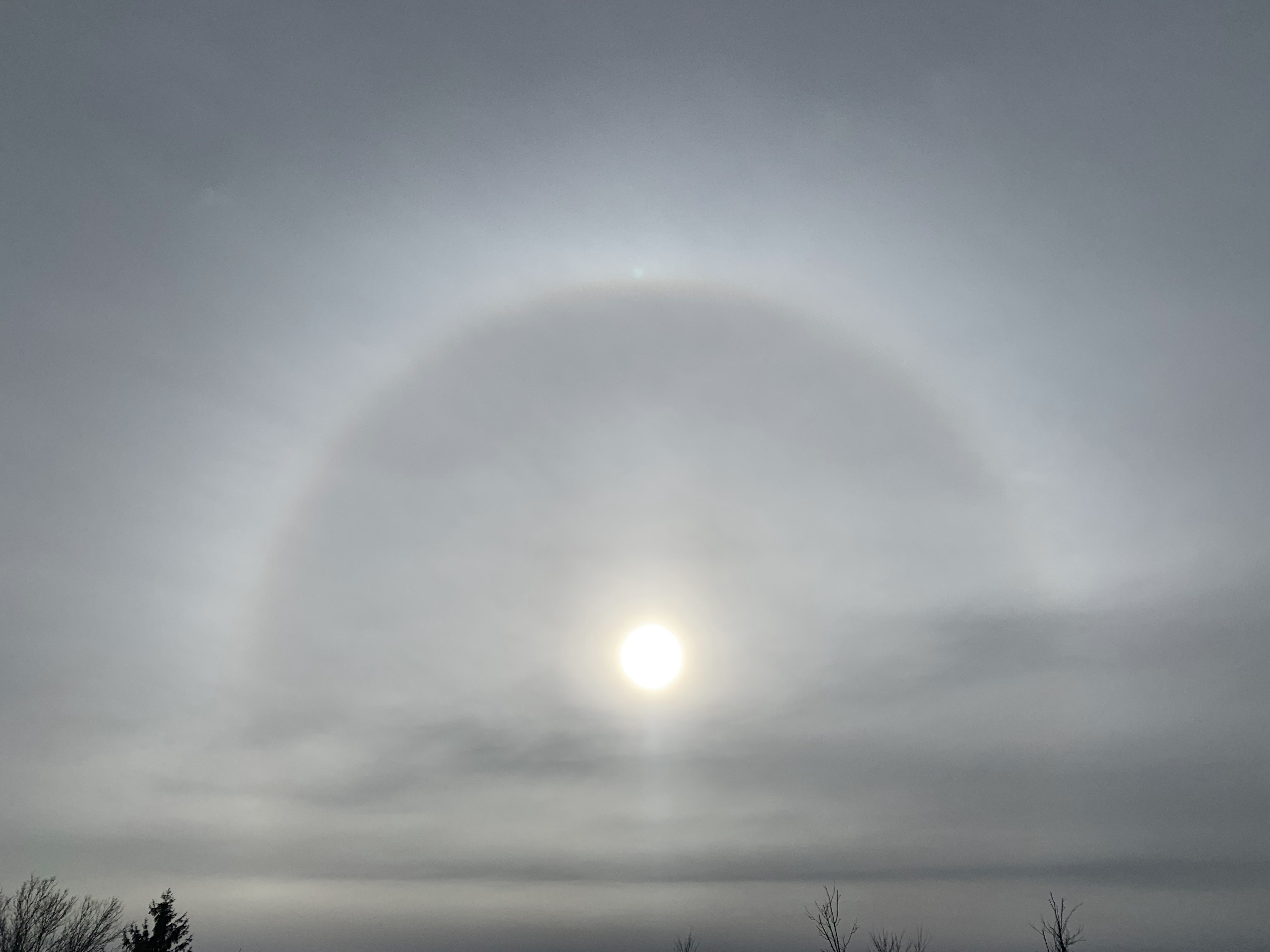
A halo around the sun as clouds increased ahead of tonight
storm. Photo taken a little after noon, Colchester, Vermont. 
 All the updated forecasts are in as of 5:15 p.m. Tuesday and we in Vermont are still in for a messy, but modest sized storm.  

The bad road conditions will affect you only if your timing is bad. If you're on the highways between, say 8 or 9 this evening and mid-morning Wednesday, you're kinda screwed. After that, it shouldn't be so awful.

I'm sure you noticed today the sky steadily went from sunny to a dark overcast by afternoon. By 5 p.m. weather radar is lit up with what appears to be precipitation falling in much of Vermont already. 

But that's virga, which is rain or snow that evaporates before hitting the ground. As is typical with a storm this time of year, it's running up against some very dry air. Snow comes out of the clouds, but evaporates in that static cling type of atmosphere.

Eventually, that evaporating snow will moisten the air, and the precipitation will then hit the ground. In Vermont, that will hit probably a little after 8 p.m. this evening in the Champlain Valley and the rest of extreme western parts of the state, and make it to the Northeast Kingdom before midnight.

FORECAST ADJUSTMENTS

The National Weather Service in South Burlington has only made minor changes to the forecast as of this evening. The onset of snow looks to be just a tiny bit earlier than this morning's forecast.

Total snow accumulation along the eastern slopes and summits of the Green Mountains in central and southern Vermont have been pulled back just a tiny bit. 

The big winners down there could see four or five inches of snow. The rest of Vermont along and east of the Green Mountains looks like they'll see 1.5 to 3 inches of snow. Low elevations of southwestern Vermont will probably see one to two inches. The Champlain Valley will get two inches or less.

There will be an interval of sleet and freezing rain thrown in overnight and early Wednesday, just to make things interesting. That's bad for the roads, but it won't be nearly enough to mess with trees and power lines. 

I'm still thinking the morning commute in the Champlain Valley might not be all that annoying. Unless something unexpected happens, I suspect it will be a little above freezing with a cold, non-freezing rain after 6 a.m. 

It'll still be schmutz elsewhere, with mixed precipitation lingering until mid morning. So you'll want to plan your trips to happen Wednesday afternoon or evening. 

Thanksgiving Day still looks great by November standards. We'll have clouds and some hints of sun, with temperatures getting up to the low 40s. Not great, but not terrible, right?

I do see some potential issues for you Black Friday enthusiasts. Another cold front should come through late Thursday night or very early Friday.  That'll drop temperatures, yield some snow showers and perhaps create some areas of slick roads as you make your way to the cold, dark, windy parking lots of the big box stores before dawn Friday. 

(Editor's note: Is it really worth it to get up that early on a Friday to shop amid too-aggressive crowds?)

Anyway, colder than average weather is forecast to continue for the foreseeable future, at least into early December. The weather pattern doesn't really favor big storms, but you never know if a surprise will pop up. 

The next chance of any kind of snow after Friday morning is Monday, but I have no clue whether it will be noticeable or nothing burger flurries. 

Sunday, November 19, 2023

The Vermont Week Ahead: November Annoyances Continue

Norway maple leaves, some still green remarkably remain
on trees in Burlington, Vermont Saturday. Warm nights 
this autumn have kept the foliage on these trees much,
much later than normal. 
Although it's been a relatively chilly Vermont November so far, I'm still struck by the lack of nighttime cold.  

So far this season in Burlington, the coldest it's gotten is 29 degrees.  

The normal low this time of year is 31 degrees, so you'd think we would have had nights colder than the upper 20s by now. For perspective record lows this time of year are in the single digits above zero.

The result is, in more urban areas of Vermont anyway, a few leaves have stuck to some trees.  

Norway maples usually lose their leaves pretty much last of all the trees except larches and Bartlett pears.  But the Norway maple leaves have in the past always been gone by early November. 

Yesterday was November 18 and the leaves are still hanging on, at least around Burlington.  I've never seen anything close to this before. Another albeit minor sign of climate change, maybe?

In any event, this week should get rid of those leaves once and for all. A pretty good cold front today will eventually plunge temperatures into the teens to maybe near 20 by Tuesday morning, so that will bring us toward winter. 

The whole week is setting up to be fairly wintry, as we remain stuck in a cold weather pattern. I don't see any epic storms coming our way, but there will be trouble from time to time. 

Let's break it down day by day.

TODAY: 

I, and the National Weather Service office in South Burlington, noticed some buzz on social media last night of the possibility of snow squalls today, which can be dangerous. 

It ain't going to happen. Take the snow squalls off your schedule today and don't worry about it. It was just the usual social media clickbait and fake news. 

With a cold front coming through today and a generally unstable environment, there's a decent chance of seeing some snow showers around. But they won't be heavy, and might mix with rain in warmer valleys. 

The favored western slopes of the central and northern Green Mountains might see a couple inches out of this, but most of us will see a dusting at best. 

MONDAY:

A cold one to start getting rid of those pesky yellow Norway maple leaves clinging to the trees, preventing you from raking the lawn. If you're in central or northern Vermont, I doubt the temperature will get above freezing all day. For many of us, it will be the first such day of the winter season.  Aside from a few mountain flurries in the morning, we might actually see some sun in the afternoon. Yippee! 

Monday night will be cold for this time of year, as mentioned, with temperatures bottoming out in those teens. Maybe some single numbers in the coldest hollows.

TUESDAY:

Quiet and cold in advance of a messy storm. Increasing clouds, highs in the 30s

TUESDAY NIGHT AND WEDNESDAY

The mess of the week, just in time for Thanksgiving travel.  The forecast details will become clear in the next day or two. But for now, expect a messy mix of wintry crap coming out of the sky overnight Tuesday and likely into Wednesday morning.

Obviously, that means roads could be kind of nasty in the morning.  At this point, it's looking like it might go over to rain in most spots Wednesday afternoon. So if you can delay your trip until then, that might be a good idea.

THANKSGIVING:

Back to quiet and cold with snow showers around. Unless Wednesday's storm somehow gets hung up nearby, there shouldn't be enough so to cause travel trouble.

BLACK FRIDAY

Sorry, but Black Friday is a day I distain.  If you want to wait in a cold, blustery parking lot hours for dawn to grab those so called door buster deals, knock yourself out. Perhaps literally, the way some people behave on Black Friday. In any event, no storms seem likely on Friday. Just snow flurries to give you a bit of holiday cheer of sorts. 

Remember the further out the forecast, the more likely it will change. Expect the forecast for later in the week, especially Wednesday through Friday, to get some updates. 

Wednesday, February 16, 2022

Wednesday Evening Update: Windy, Rainy, Icy, Messy Vermont

Small tree fell on my St. Albans, Vermont property today
amid high winds, barely missing my electrical lines. Lots
 of branches and small trees came down amid wind gusts
 of more than 50 mph today in the Champlain Valley.
It was the opening salvo in a very stormy period.
 We're still anticipating all kinds of weather problems in Vermont now through Friday, so let's just get into our Wednesday evening updates.  

Winds really did ramp up or awhile today, especially in the Champlain Valley, with gusts over 50 mph in many spots in the valley, and I'm sure a couple of gusts to 60 mph or a little more swept through some of the Champlain Islands.

The winds were just strong enough to knock off some branches and topple some dead trees, but I haven't seen in my travels today any widespread damage. I had to stop and remove a few branches from some roads out in Grand Isle County as I drove out there, but they were small enough that I can move them unassisted.

Power outages have been modest, which is nice. I have a lot of new sticks to pick up around my St. Albans, Vermont yard, including a fallen dead tree that just brushed, but did not damage my electrical lines. 

As of 5 p.m., we're not quite done with the winds. They diminished a little by mid-afternoon, but the National Weather Service office in South Burlington has detected signs of another surge in winds for a few hours between now and mid-evening.

I've noticed as of 5 p.m. the winds do seem to be increasing again around my St. Albans, Vermont hacienda. mid afternoon. They'll diminish some later this evening but continue to blow all night. The high wind warning in the Champlain Valley stays in effect until 10 p.m. tonight. 

Oh, but that's just the start. As I've been indicating, we have a lot more to get through. 

Trends in forecast guidance bring a little more precipitation over our area than thought earlier today. The path of the main storm also keeps trending ever so slightly toward the south and east, putting more of Vermont in play for wintry precipitation -  and more of it. 

Most of us got above freezing this afternoon after a cold start to the day. It should remain above freezing overnight in most of the area. 

By tomorrow, temperatures will get into the upper 40s to mid 50s in much of Vermont, so that will really get  the snow melting. Since the strong stalled weather front to our north is going to be closer to us than originally thought, Thursday will probably be rainier than we forecasters thought this morning

That's especially true in the northwestern half of the state. Rain will get heavier Thursday evening, and that will eventually lead to some river flooding and ice jams statewide. A flood watch remains in effect from tomorrow afternoon through Friday afternoon.

Thursday night will be rough especially in the Champlain Valley.  The forecast is especially tricky here, and there will be adjustments. The National Weather Service in South Burlington thinks there will be a period where north winds and south winds converge mightily.  When that happens, precipitation tends to come down really hard. 

After we get through the heavy rains the flood threat, and then
sleet and freezing rain, some snow will come down at the tail
end of the storm Friday. There's a high bust potential in 
this map could go strongly either way. 

But what kind of precipitation?  Will the bulk of the precipitation late Thursday night there be mostly rain? Or freezing rain and sleet? Or snow? Forecasters are pretty sure there will be a lot of whatever comes down, but exactly what it will be is really a question.

Going forecasts have drenching rains and flooding in most of the Champlain Valley until midnight, give  or take, then an icy mix of precipitation, then snow as we get toward dawn.

There's a really high bust potential here.  There could be much more, or much less of any type of rainy, icy, snowy stuff. But the going forecast has rain, then a lot of sleet and some freezing rain late at night, then eventually two to four inches of snow in the northern Champlain Valley. 

Over in New York State, the St. Lawrence Valley could end up with up to a foot of snow and sleet. Back in Vermont, current forecast have an inch or less of snow south and east of a Newport to Middlebury line.  Most of the precipitation in these areas will be rain, some of it will be heavy, so ice jams and flooding are a real threat from Thursday evening into Friday. 

A winter weather advisory is in effect for roughly the northwestern half of the state Thursday night and Friday. 

At this point, freezing rain likely won't be enough to damage trees and power lines, but we'll still have to keep an eye on that. 

Despite the iffiness of exactly what will come out of the sky, prepare yourself for an awful Friday morning. Temperatures will be falling really, really quickly by dawn Friday, and we'll have ourselves a flash freeze. That means all the water, slush and schmutz on the roads, sidewalks, your car, your driveway, everything, will turn into a solid mass of ice. 

Plan now to stay home Friday morning if at all possible. I expect another long, long, long list of school closings Friday morning.  It might not be too, too bad in southeastern Vermont, but the further north and west you go in Vermont Friday morning, the worse it will get. 

The weather pattern looks like it will stay pretty active into next week, but let's not get into that now. We have enough on our plate. 

Thursday, November 18, 2021

I Demand World Meteorological Organization Approve These New Weather Terms

People in Burlington, Vermont walk gingerly on icy 
sidewalks after a bout of Sleeze (a mix of sleet and
freezing rain) on Feb. 6, 2019. 
 We're getting into the winter weather season, which means many of us in the Northern Hemisphere are starting to deal with a variety of nasty winter precipitation types.  

As great as outfits like the National Weather Service and countless local meteorologists are, we really need to make winter weather terms, shall we say, punchy. It'll get everyone's attention .

I was inspired by this yesterday when a few half melted sleet pellets landed on me when I was trying to get my last garden stuff done before winter.

The sleet was basically slush. Not really ice, not really water. 

So, what fell on me Wednesday was Sleesh

That's a mashup between sleet and slush. It gets the point across.

This got me thinking about other types of winter precipitation and which words we should use to describe them.  

Here's a sampling of what I came up with. 

Frizzle: Freezing drizzle. Just mash up the two words to make things efficient. 

Sleeze: A mixture of sleet and freezing rain

Slain: A mixture of sleet and rain.

Sneeze: A mix of snow and freezing rain.

Sneet: Mixed snow and sleet.

Sleeze: Mixed sleet and freezing rain. 

Snain: Mixed snow and (non-frozen) rain. 

Snail: Graupel. Which is essentially a hail/snow combo all in one, so just combine snow and hail into one word. 

Some of the words I came up with are already in use for decidedly non-meteorological things.  But I'm sure the wordy dictionary loving types can come up with new words, to describe issues like what we do when we have allergies, the past tense of a murder, and a slow moving, shelled gastropod. 

We've all had to make big adjustments during this long pandemic, so what's another adjustment to the English language?  I'm sure non-weather geeks could find other words  "Slain", "Sneeze" and "Snail" and let us have those words. 

This is a demand, a plea, to the World Meteorological Organization to accept these words as official, scientific weather terms. 

To keep up the pressure, lets get the National Weather Service, Environment Canada, the UK Met Office and all the other national weather bureaus to sign on.  Plus the private weather companies, like the Weather Channel, AccuWeather, WeatherNation and others. 

The bottom line is we need to make bad weather as fun as possible. These words do the trick. 


Saturday, February 13, 2021

Winter's Grip Intensifies In Nation, Including Here In Vermont

I can't remember the last time I saw so much of the nation
covered in winter warnings and advisories. Notice the
huge area of Oklahoma, Texas and Arkansas under 
as winter storm warning (pink color) 
 Yesterday I illustrated this blog thingy with the National Weather Service home page which showed all those blue winter weather warnings.  

I'm doing the same today because I don't remember the last time so much of the nation was covered by winter storm warnings, watches and advisories, and will chill warnings and advisories. If you eyeball it, I'd say 70 percent of the nation is under the above alerts. 

You can see we here in Vermont are conspicuously outside those alerts, but that will change as the week goes on. 

Those future Vermont advisories won't include wind chill alerts, but it was still freakin' cold out there this morning. Not nearly as cold as it can possibly get in February, but chilly enough. In northern Vermont outside the Champlain Valley, pretty much everybody was in the teens below zero. 

That's not nearly as bad as the 30s and 40s below zero weather that is surely delighting the denizens on parts of places like North Dakota and Minnesota, so we'll take it 

Plus, for us, the breeze wasn't blowing much this morning, so wind chills aren't excruciating. Plus we're in for a warming trend around here. Which is nice, but the weather will get quite a bit more active. All those winter storms slamming most of the United States won't stay away forever.  

WHAT'S IN STORE

It'll stay cold in Vermont today as the Arctic air remains in place.  It'll only be a couple degrees warmer than yesterday as afternoon clouds increase. 

A nothing burger little disturbance, starved for moisture, will come through late tonight, tossing down a handful of flakes ( dusting to an inch valleys, up to 2 inches mountains).

That'll zip on out of here in time for us to enjoy a Sunday afternoon, partly sunny heat wave - highs in the 20s! 

Remember, though, I've been touting that bending jet stream all week, and how it will orient itself southwest to northeast over the Eastern Seaboard.

That is indeed setting up. It'll bring moisture up from the south, so more light snow will break out by Monday afternoon. It won't amount to a whole lot, but enough to sweep or shovel away. 

Then that next touted storm comes along Tuesday.  That one looks to be a little too far south to give us a huge dump, but close enough to give at least some of us a few inches of snow  anyway.  Especially in southern Vermont.  This is when we'll start to share in those winter alerts from the National Weather Service. If this forecast holds, I'm sure they'll issue winter weather advisories for snow, at least in southern Vermont. 

After a break with dry weather and just slightly cooler than average weather midweek, the forecast is still calling for a bigger, wetter storm for us Green Mountain Boys and Girls. 

Hard to tell if we're in for snow, a mix or even rain at this point but the potential is there for a lot of something to fall from the sky. 

STUNNING NATIONAL PICTURE

This weekend and the first part of the upcoming week are turning out to be pretty historic in the weather department, especially across the South. 

A glimmer of hope. Long range forecasts for the end of 
February indicate chances of above normal temperatures
in the northern Plains, Texas and Oklahoma, the areas
being hardest hit by the current spate of winter weather. 

All of Oklahoma is under a winter storm warningVirtually all of Texas and most of Louisiana is also under winter storm watches, warnings and/or wind chill alerts, which is pretty remarkable. 

One of the most memorable aspects of this siege of winter weather is how much ice - freezing rain and sleet - has come with this and will continue to come. 

I've noted that horrible ice-related wreck in Fort Worth the other day and that ice storm that damaged trees and power lines and caused too many vehicle crashes to count in Kentucky and Arkansas.

Vast parts of Texas were being hit again by ice this morning. Freezing drizzle, freezing rain and sleet will continue in large parts of Texas, all the way down through what is normally pretty tropical Houston. 

Temperatures in the South during and after this storm will be extreme to say the least. Monday afternoon temperatures in Dallas could well be at or below the record low for the date of 13 degrees. 

This whole thing in Texas is especially dangerous as widespread power failures are likely as temperatures fall into the single numbers at night through most of the state Sunday and Monday.  Pipes will freeze in countless buildings. Travel will be all but impossible probably in more than half of Texas come Sunday and Monday. 

Crop damage in the southern half of Texas will be massive.  I also hope people take their pets indoors during this. The National Weather Service in Brownsville, in the southern tip of the state, just issued their first winter storm watch in a decade. 

As the National Weather Service in Houston warns residents: "Remember the 4 P's: Pipes, people, pets and plants."

A second winter storm of freezing rain and sleet is expected in Texas Wednesday. 

Oklahoma is facing some of its most intense winter weather in history.  The temperature there fell to 20 degrees this past Monday and won't get above that level again until Thursday.  That's at least nine consecutive days at or under 20 degrees in a city whose normal highs are in the mid 50s this time of year. 

 That freezing rain is extending, and will cover many areas of the East in the next few days. Already, an ice storm was underway this morning in Virginia. Power outages were already occurring there, and will get worse as the freezing rain continues all day.

Off and on freezing rain and sleet is likely from the Mid-Atlantic States today through Tuesday. 

In the Ohio and Tennessee valleys, where trees and power lines are laden with ice already, a snowstorm is coming Sunday and Monday followed by more snow and freezing rain later in the week. It seemingly doesn't end. 

It's even hitting the West Coast. At least 266,000 homes and businesses in Oregon were without power after a big ice storm hit Portland and surrounding areas yesterday and overnight. 

Perhaps we in Vermont are missing out on this extreme weather. Thank goodness! This siege of winter weather has killed at least a dozen people in the United States since midweek.  I'm afraid this will prove fatal to many more, since vast areas that aren't used to winter weather are getting nailed. There's already also been a lot of property damage, and a lot more of is coming to homes, businesses, farms and crops throughout much of the South, Midwest and East. 

You'll see a LOT of rough winter headlines in the news in the coming few days.