 |
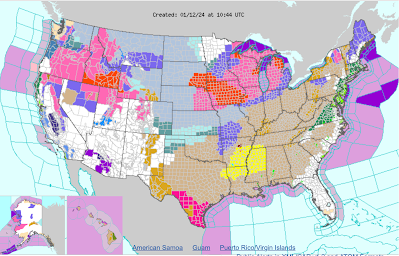
| The National Weather Service web site home page was even more colorful this morning than it was before the last storm, which means there's a LOT of weather hazards going on coast to coast. |
It's not just Vermont, of course. This new, vast storm is creating a blizzard in the Midwest, severe weather and a tornado risk in the South and Southeast, and yet another round of flooding along the East Coast from North Carolina to Massachusetts.
Here in Vermont, the two storms are turning out to be very similar to each other. I'm calling the two storms twins, because they are so like each other. But like twins, each storm has its own personality.
With this new storm, some of the highest winds might hit slightly different areas than last time. This one also might have a little more snow and a little less rain than the last one. The timing of when both storms ultimately hit is similar, but the one starting tonight arrives just a few hours later than the last. The new storm also departs a tiny bit later than the previous one.
And the aftermath of the storm will be pretty different from the last one.
WINDS
A high wind warning is now in effect for Bennington, Addison, Rutland, Lamoille and Orleans Counties. And along the western slopes of the Green Mountains in eastern Chittenden and Franklin counties.
Winds could easily go as high as 65 mph or more in some of these locations, which sets the stage for more tree and power line damage. As of 6 a.m. today, more than 2,000 customers were still without power from the last storm. No rest for the weary, I guess.
Power outages will start increasing late this evening,
 |
| People in St. Albans, Vermont this past Wednesday cleaning up after the big wind storm. More cleanup is likely Saturday as Big Windstorm #2 looms. |
Easterly downslope winds put places like Rutland and Middlebury more in play for strong, damaging gusts. I do think Rutland might have a harder time with this storm than the last one.
The easterly component might give places near Lake Champlain a bit of a break from the wind, but no guarantees there.
Outside the high wind warning zone, there's a wind advisory up for all of Vermont except the southeast corner. Winds could gust to the 50 to 55 mph range in the advisory zones.
Any time you get gusts to 50 mph or more you're going to have a few problem with trees and power lines. In northwestern Vermont, remember, there's still a lot of damage left from the last storm. That makes this area more prone to damage due to trees weakened from the last storm and power lines that have been hastily repaired, with the work not quite finished.
Peak winds with this storm should hit between 3 and 8 a.m. Saturday, says the National Weather Service.
SNOW
As noted, this storm will have a little more snow and mixed precipitation and less rain than the last one.
Once again, the heaviest snow will be along the Green Mountains and south and east facing slopes. A winter weather advisory is up for up to six inches of snow in these areas.
The snow will come in later in the evening than it did Tuesday, so it won't affect anybody trying to drive home from work at say, 6 p.m. tonight. Most of the snow action comes after 8 p.m.
It'll once again be a fairly heavy, wet snow. Combined with the winds, this is a recipe for additional power failures.
Travel late tonight and Saturday morning will be a pain and probably a bad idea due to slick roads, along with trees, branches and wires down on some roads,
The Champlain Valley should see maybe one to three inches of snow before a changeover to rain early Saturday. Again, not much rain, so no flooding.
POST-STORM
After the worst is over, winds will go into a lull in the late morning to maybe early afternoon Saturday. Then they'll pick up out of the southwest and get a little gusty. I don't see the gusts going any higher than 35 mph later in the day. But that's still maybe strong enough to interfere with power line repairs a bit.
Rain and snow showers will linger through the day Saturday, but none will be heavy. Temperatures will peak near 40 degrees in the early afternoon, then slowly fall through the 30s.
We'll probably start to pick up very light dustings of snow Saturday night and Sunday, especially in the mountains as temperatures keep cooling.
Winter finally hits after this storm, as I don't see any thawing temperatures for more than a week after it gets under 32 degrees Saturday evening.
We still have a shot at another storm Tuesday or Wednesday, but that's really iffy at this point. Some computer models give Vermont a fairly decent snowfall, others give us pretty much nothing. Stay tuned!

No comments:
Post a Comment