 |
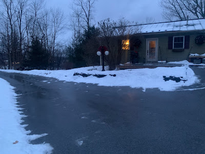
| As dawn broke in St. Albans, Vermont today, not much wind and the power was still on, but elsewhere in the state dangerous gusts were cutting power to thousands of homes and businesses. |
Power failures were rising fast as strong downslope wind gusts raced down from the spine of the Green Mountains into western Vermont valleys.
This post was put up at around 7 a.m. today, so I'm sure a lot of new power outages and other incidents have happened this morning as you read this. I'll do my best to provide updates later today.
According to VTOutages.org, Vermont went from about 700 homes and business without power as of 2:30 a.ml to about 4,100 by 3:30 a.m. and 13,000 by a little after 6:30 a.m.
At this trajectory, I'm beginning to wonder if the power outages will be more widespread than in the storm Wednesday.
You could watch on VTOutages.org as the strong winds appeared in Bennington County, spurring outages, and then they spread to Rutland, then Addison, then Chittenden counties. The wind storm was clearly moving south to north across Vermont.
Rutland is an example. Top gusts there at 2 a.m. were a manageable 28 mph. By 6 p.m. gusts were already at 49 mph there. Bennington was reporting 49 mph gusts too. Gusts were around 55 mph in Bolton as of about 3:30 a.m.
We'll surely see reports of higher gusts as the morning wears on.
I am seeing some road closures pop up, too. Route 2 in Williston near Gov. Chittenden Road was closed by a fallen tree and wires earlier this morning.
So far the gusts with this storm seem sporadic. There was a bit of an inversion in spots early on in the storm that deflected some of the downslope winds upward and away from the valleys. Other gusts broke through.
In some areas, the strong gusts were frequent. In others, they were few and far between. However, as rain and snow wane at dawn, the inversion was weakening, opening the door for more strong damaging wind gusts.
Here in St. Albans, myself and Jackson the Weather Dog went outside at around 5:30 a.m. to gauge conditions. Winds were light at our house, but up the hill and overhead, we could hear what sounded like loud jet engines. The wind was screaming up there.
By 7 a.m. the wind here was picking up but so far was not damaging. But we have time for that to happen, and I expect trouble here in Franklin County soon.
The risk of damaging winds will continue until 9 or 10 a.m.. There were signs the wind was worsening after a band of rain and snow passed to the north. This was expected, as the higher winds would come after the initial thump of precipitation.
By the way, that initial thump hasn't panned out to be quite as heavy as many forecasts indicated. In the Champlain Valley, it was rain mixed with snow as it had warmed up quite a bit. In the southern and central Green Mountains, it was snow, but I do wonder if they'll pick up the full four to seven inches that was predicted.
We shall see!
After 10 a.m. the worst should be over. We'll have lighter winds during the day with scattered rain showers around. Those will trend toward snow showers later today and tonight, but not amount to much at least not in Vermont.
Winds will get gusty again late this afternoon and tonight, but not nearly at the level we saw early this morning.
Still, gusts to 35 mph might fell a few weakened branches and slow the work of restoring power a little bit.
It does look like a huge lake effect snowstorm is brewing for northwestern New York as winds blow off of Lake Ontario starting later today and continuing at least into Monday.
There's still a lot of questions as to whether we might get a snowstorm around Wednesday. I'm leaning against the idea just a little, based on current projections. But I could easily be wrong, as some models do bring a decent dump to Vermont.
That's another thing we'll need to stay tuned on.

No comments:
Post a Comment