That's saying something, considering how stormy it's been since late November.
As I said this morning, I hope you like rain, freezing rain, drizzle, freezing rain and fog/freezing fog.
Sun is a distant memory. We haven't seen it since Monday morning, and we won't see it again until Sunday at the earliest. But more likely not until Monday.
The storminess we're entering into isn't the strongest of the winter. But it's the ugliest.
This afternoon, temperatures did manage to get above freezing in much of western Vermont, but it still was a lousy day with low, gray clouds, an unpleasant south breeze, and patchy fog and drizzle.
A warm front of sorts has passed through western Vermont, but has stalled out before reaching far northern and much of eastern Vermont.
As a result, much of central and eastern Vermont held near or a bit below freezing.
Both these facts kind of spell out our future tonight into Saturday night. Before we get into it, since temperatures will be so close to the freezing mark, some of what I outline might end up being a little off. Some areas might get a bit more ice than expected, others might see a little less.
But less slide on into the forecast:
TONIGHT
The air has warmed up aloft quite a bit since this morning. So a new area of precipitation that was just entering our area as of 5 p.m. is pretty much all rain. Not snow like this morning.
But the low level cold air is hanging tough along and east of the Greens. That means it will be mostly freezing rain overnight in those place. I don't recommend driving anywhere in those areas from about now (5:30 p.m. Wednesday) to Thursday morning.
Forecast rainfall amounts have also ticked up since this morning. That makes me wonder whether power outages will be an issue in parts of eastern Vermont. I don't think it will be anywhere near as extensive as during those awful wind storms on January 10 and 13.
But a quarter inch of ice accumulation is where tree branches and power lines start to have trouble. Some areas in eastern Vermont will have that much.
On the bright side, widespread power outages usually don't start happening unless there's more than a half inch of ice, and that isn't in the forecast through Thursday morning.
In western Vermont, enough cold air might bleed in from the north tonight to make parts of Franklin County pretty icy. Even if it stays above freezing, the rain will freeze on cold surfaces that aren't treated with salt. I'm talking back roads, driveways, sidewalks, that sort of thing.
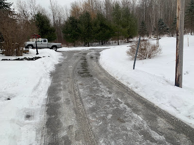
I noticed today at my place in St Albans, Vermont, parts of my driveway thawed, while the ice has hung on stubbornly in other sections. We don't salt our driveway, because that would hurt the paws of Jackson the Weather Dog. My driveway is just an example of how things will play out tonight.
THURSDAY
Another lousy day in Vermont. The main batch of rain and freezing rain will move out by dawn or shortly thereafter.
That will leave us under a layer of low, thick clouds. We'll have areas of fog and patchy drizzle and freezing drizzle. If you have Seasonal Affective Disorder, this will be another tough one.
Especially since another round of rain and freezing rain will be on our doorstep.
THURSDAY NIGHT/FRIDAY
That will come in overnight Thursday night and last well into Friday. I suspect the freezing rain won't be quite as widespread as tonight but that's not a guarantee. I still worry about a few places that don't thaw out Thursday, then get more freezing rain Friday.
Friday will be another day of low clouds, fog, drizzle and light rain and/or freezing rain. In some placed all that will keep freezing. Where it remains above freezing it'll only be in the mid 30s. That's quite warm for this time of year, but bone chilling given the fog and drizzle.
BEYOND FRIDAY
It'll stay mild Saturday and maybe into Sunday, but the clouds will hang tough. We're still watching yet another storm later Sunday. So far, it's still looking like that one will stay too far south to give us much precipitation. Even if it does, the atmosphere will have cooled enough to give us snow, not freezing rain.
Cross your fingers but longer range forecasts indicate we just might have a quiet weather week next week. Sometimes boring weather is a good thing.


No comments:
Post a Comment