Showing posts with label fog. Show all posts

Friday, December 27, 2024

Strange, Extreme Temperature Inversion To Finally Break, Then Freezing Rain, Then Rain To Mar Runup To New Year

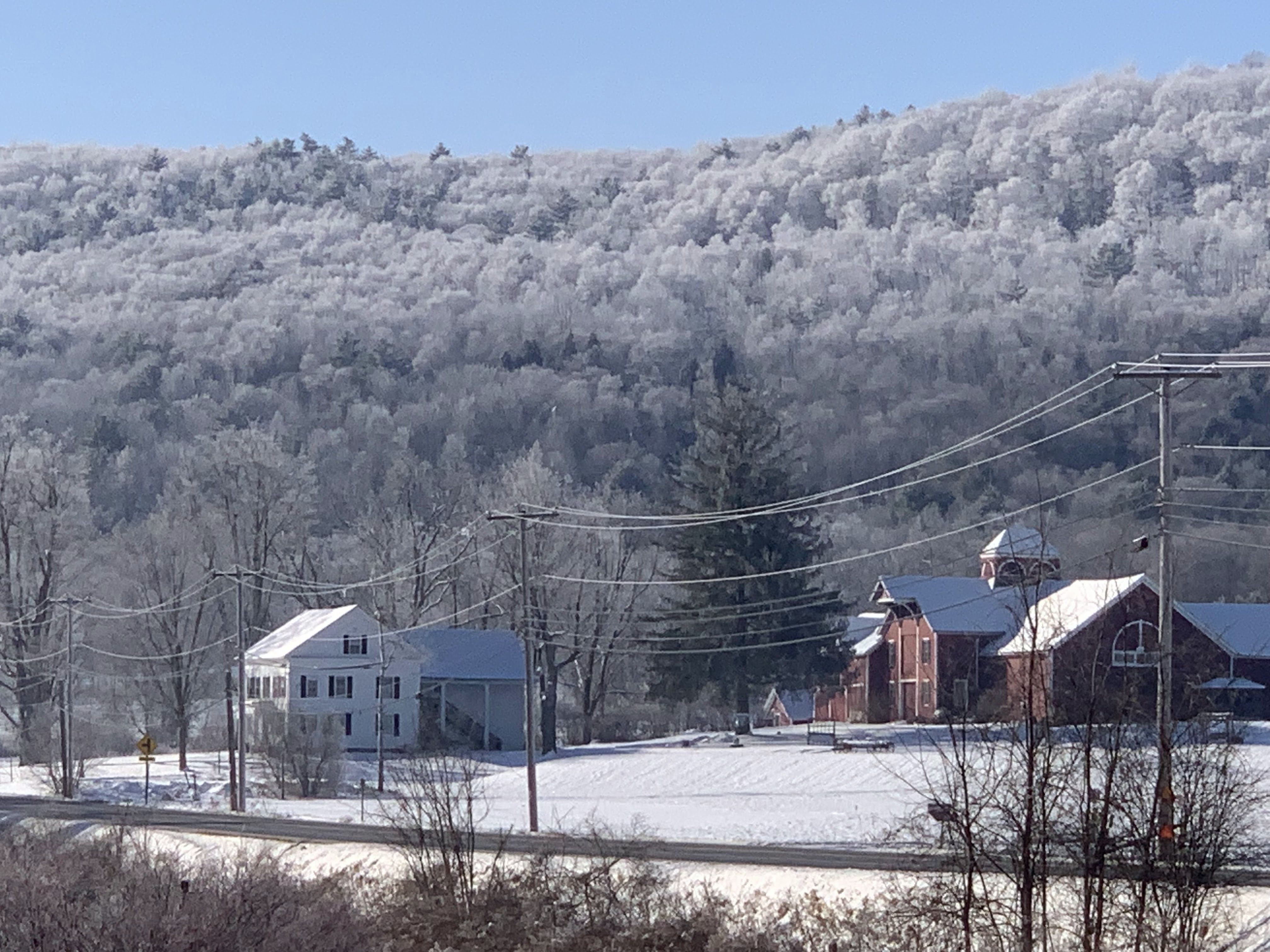
Freezing fog under an inversion broke up Thursday 
morning, leaving frosted trees glistening above an
old farmstead near Wallingford, Vermont. 
 Though it might not seem it to the casual observer, the weather has been really strange from Christmas Day to this morning in and near Vermont. 

As previously forecast, an extreme temperature inversion has taken hold.  To remind you, an inversion is when it's warmer aloft or up in the mountains than in the valleys. Usually the opposite is true. 

Inversions are more common in the winter around here, but this one is really something. 

Atop the high peaks of the Adirondacks Thursday morning, like the summit of Mount Marcy, temperatures remained in the mid 30s, even at night as temperatures in the coldest valleys got down to below zero readings. That's about as extreme a temperature inversion as I've ever seen.

The inversion has trapped the steam coming off unfrozen Lake Champlain, creating a widespread blank of low clouds and fog to spread out from the lake and cover most of western Vermont and nearby New York, both yesterday morning and this morning. 

With light north winds, I noticed the clouds were never able to break up Thursday downwind of Lake Champlain. Much of Addison County, southern Chittenden and northern Rutland counties remained socked in with clouds, even as most other areas cleared.

Where the low clouds and fog did break up in those chilly valleys, the freezing fog left behind a beautiful frost on all the trees, lit up by the low angle late December sun. It was an example of how inversions can be stunningly beautiful.

Freezing fog early Thursday left these trees in 
West Rutland, Vermont beautifully frosted over. 
This morning, temperatures in the inversion remain topsy turvy to the extreme. Under clear skies early this morning, it was 9 below at Lake Eden, Vermont and minus 7 in Morrisville. The low clouds and fog from Lake Champlain kept Burlington a little warmer at 14. 

Meanwhile, it was still in the low 30s in the high peaks of the Adirondacks. The summit of Mount Washington, New Hampshire, a place you usually find extreme cold, it was a balmy 28 degrees a little before dawn.  

Freezing fog has been an issue in spots and night, but it's been beautifying our surroundings during the day, especially where sun breaks out. The sun glistening on trees frosted over by the fog is just stunningly beautiful, so enjoy that if you see it. 

FREEZING RAIN

The inversion will gradually fade as the strong high pressure system finally exits in favor of that storminess we've been watching approach. 

Still, the inversion's fading glory will cause new problems.  That warm air aloft will continue flowing in, and will try to work its way down into the valleys. But only grudgingly.  An initial wave of precipitation is forecast to push northward into New England  Saturday while fading as it encounters dry air over Vermont and New Hampshire. 

What does arrive will start out as plain rain as it falls through the mild air a few thousand feet overhead. But it will probably freeze on impact as it lands in the cold air and cold ground down southern Vermont valleys. 

A winter weather advisory is up for the southernmost two counties of Vermont and adjacent areas of New York Saturday as that freezing rain arrives.  It won't come down hard, so there will be no issues  with trees and power lines, but there will be icy problems on the highways. 

There's some question as to  how far north Saturday's freezing rain will get, but a little dab will do ya - Even 0.01 inches of freezing rain is more than enough to make roads and sidewalks dangerous. I have a feeling those Saturday winter weather advisories might get extended at least into central Vermont.  

Not sure yet, but it's something to watch.

A more substantial surge of warmth and moisture will push northward Sunday, so we get more rain. Some valleys in eastern Vermont might not be above freezing yet even on Sunday, which opens the door for more freezing rain. 

In western Vermont, temperatures are forecast to be above freezing when the rain arrives, but that might not be much help. 

The air temperature might be in the mid and upper 30s while it's raining Sunday, but the ground will not have recovered from the cold valley temperatures we've had under this week's inversion.

 Pavement, concrete, etc. will still be below freezing, so that rain Sunday would probably freeze on roads, sidewalks and driveways. Especially if they haven't really been hit with the state and municipal salt shakers that I expect will be out. 

Eventually, it will warm up everywhere in Vermont by Monday for just plain rain. 

Saturday, August 24, 2024

Fog Season In Vermont Has Arrived And This Year Could Be A Doozy

Sunflower stalks on a foggy morning late last
fall in St. Albans. Vermont 
 Every year, in the final days of summer and the first half of autumn, dense morning fog is a frequent visitor in Vermont.  

The nights begin to get a little cooler. Meanwhile, lakes, ponds, rivers, even the soil is near its peak temperature of the year. 

These bodies of water, and the soil, and the leaves on the trees, emit moisture. When the temperature drops overnight, that moisture condenses into fog. It clings to the river valleys and can cut visibility to near zero until it burns off by mid morning. At least usually. 

The season has started already, as it often does in August. Patchy dense fog was scattered around Vermont early this Saturday morning. 

This autumn could well be an especially foggy one.  It was a much warmer than normal summer, last week notwithstanding, so water and soil temperatures are higher than they usually are. 

The increased contrast between the cooling nights and the warm water and soil is a recipe for fog.

Satellite view this morning shows fog in river 
valleys, especially the lower White and Connecticut
River valleys. 

You surely noticed this summer was also really, really wet. Soils moistures are high, so that adds a lot of water to the atmosphere. The more moisture available in the air, the more likely you're going to have fog.

Even in nights when humidity is low, the moisture coming from the ground, the rivers, the lakes, the leaves on the trees can really add plenty of ingredients for fog.

From now into October, any night that is at least sort of clear and calm will give us a bunch of fog. 

The morning fog in the autumn can be spectacularly beautiful. When foliage season hits, I always recommend people get an early start. The photographs of the fall foliage emerging into sunshine from the fog can be incredibly gorgeous. 


Of course, the autumn fogs can be dangerous. You're blasting down the road in clear air, and all of a sudden you punch into a fog bank. 

Visibility goes to zero, and you don't even see the car braking ahead of you, until it's too late. And yes, the fog can be dense enough so that you don't see the brake lights.  

Over the next few weeks, the sun is still strong enough that the fog will surely burn off by mid morning. The sun heats the air, the contrast between the cool air and the warm ground disappears, so blue sky and sunshine quickly re-appear by 10 a.m or so.

Dense fog cuts visibility to near zero on a 
St. Albans, Vermont street last year. 

Later in the autumn, the sun angle is lower, so the heat is not as strong. Especially this year, I imagine, we'll end up with several days that on paper should start out foggy then turn sunny. Instead, those days sometimes turn out to be entirely gloomy. The fog lingers, then maybe lifts into a low, gray overcast. The mountain tops end up in the sun, but us valley dwellers experience a dreary day. 

On some of those days, the sky finally clears late in the afternoon, only to fog up again that night. 

Fog can be beautiful, giving our surroundings a mysterious air. But much like in the winter, plan on leaving a few minutes early for work on calm mornings. Patches of fog will mean you'll need to drive more slowly. 

Friday, January 26, 2024

Quick Friday Evening Vermont Update: Just Damp/Foggy/Icky Overnight

Traffic makes its way along Interstate 89 in Colchester,
Vermont this morning amid a cold rain, fog and gloom.
 Luckily, today's storm wasn't too, too bad. It was just an ugly winter day. 

The areas of freezing rain weren't that big, and didn't accumulate much, at least in Vermont. 

As expected, the rain changed to snow in mostly the Northeast Kingdom, and it didn't amount to much.

Most of us ended up with a miserable, cold, soaking rain. Many of us ended up with close to a half inch of rain.

The precipitation is over for the night. Except perhaps patches of drizzle, freezing drizzle or a few wet snowflakes. 

All of those winter weather advisories we had earlier have been canceled. 

For tonight, the main problems will be that seemingly ever-present fog. And patches of ice on roads, especially east of the Greens.

The bigger of the two problem will be the fog. It was already pretty dense in several spots as of 5 p.m. With light winds and lots of moisture, that fog will linger, and reduce visibility on the roads. You'll need to slow it down tonight.  

Use your low beams, not the high beams.  The high beams will blind you mostly, but also people coming the other way through the fog. 

Temperatures will fall to near freezing, so we might have issues with ice on untreated surfaces again tonight through early tomorrow. 

Saturday is looking murky.  But almost precipitation free, with just possible a patch or two of drizzle or wet snowflakes. 

That potential storm Sunday or Sunday night is still trending too far south to bother us much, but there's still an opportunity for it to curve north.  Meteorologists are monitoring trends with that one. 

Thursday, January 25, 2024

Thursday Evening Vermont Ice Update: A Little Colder, A Little Icier

Compared to forecasts we saw this morning, expected ice
accumulations depicted in this map released by the 
National Weather Service office in South Burlington 
have increased. Red areas should expect at least
a quarter inch of ice. 
 The forecast for the new round of ice, freezing rain, rain and general ick for tonight and tomorrow across Vermont and surrounding areas has gotten a little worse, I'm afraid. 

Settle in, folks, this is impossible to explain in 100 words or less, so here we go:

Cold air is being stubborn across northern and eastern Vermont, and that, I think, will make the ice a little more widespread than earlier forecasts. Not everyone will get freezing rain, but everyone will need to be on their toes.

Even in the Champlain Valley and southwestern Vermont, which I thought earlier would be mostly safe from any ice. 

The National Weather Service office in South Burlington has hoisted a winter weather advisory for all of Vermont for ice, and a little snow in spots. The advisory runs from early Friday morning until 7 p.m. or so Friday evening. 

However, some of the fun begins even before the real precipitation and ice arrive in the wee hours Friday morning. 

Cold air has been draining into the northern Champlain Valley all day. It stayed at or below freezing here in St. Albans all day amid a dense fog. Interestingly, Burlington was a little above freezing all day, but dipped to 32 degrees at 4 p.m.  

Elsewhere, most of Vermont was a little above freezing this afternoon.

We will see problems with dense fog in some areas this evening. Also, patchy freezing drizzle will make road conditions a little dicey and unpredictable in spots.  This includes areas of Vermont outside the chilly Champlain Valley, as temperatures dip slightly through the evening hours. 

FRIDAY

As the next in the series of modest but rather wet storms approaches tonight, east breezes on its northern flank looks like it wants to tug in some slightly colder air in the lower levels of the atmosphere from high pressure parked north of Maine.

This would make freezing rain more likely. 

Water droplets remained frozen solid to tree branches all
day in St. Albans, Vermont amid dense, cold fog.

The fun will start before dawn and continue through the morning commute hours. So the timing stinks. I still expect some school closings, or more likely school opening delays on Friday. 

Like the last round we had late Wednesday and early today and despite the current chill, the Champlain Valley looks marginal for rain vs. freezing rain Friday.

 I imagine it'll be patchy, with some areas fine, others icy. And temperatures there, and in some other parts of Vermont will probably fluctuate near the freezing mark during the precipitation all day Friday. 

Remember, even if it's a little above freezing, ice could still form on driveways, back roads, overpasses and deeper valleys. 

Areas from the Green Mountains east are much more likely to see freezing rain instead of rain, but even there, it might be patchy. 

Also, with temperatures so close to turning things icy, there's tremendous bust potential in the forecasts. It's possible we end up with quite a bit more ice than forecast, or quite a bit less. 

So it'll be a crap shoot as to who gets icy, who stays wet.  Just assume if you need to drive to work or school tomorrow chances are you'll encounter ice somewhere. 

At least for awhile.

IT'S COMPLICATED 

That cold air being pulled in from the east by this storm will gradually take up a thicker and thicker layer of the atmosphere. So during the day, rain or freezing rain will slowly mix with and change to a little sleet and some wet snow

That changeover process will start in the Northeast Kingdom in the morning, then spread west and somewhat south during the day. 

This is actually good news for parts of northern Vermont because it would cut down on the amount of freezing rain that will fall.  If this pans out as expected, there won't be much snow, even in the Northeast Kingdom. Up there, it'll probably amount to one to three inches. 

I'm not even sure the snow will reach the Champlain Valley. If it does, it won't amount to much.  Central Vermont will probably see an inch or less of snow.

Southern and central Vermont is least likely to see snow and sleet. Which means - if Thursday evening forecasts are correct - some areas in and near the Green Mountains from about Sugarbush south could see a good quarter inch of new ice from the freezing rain. 

Especially in spots where any ice didn't really melt today, this puts the risk of scattered power outages in play. Remember, in most ice storms, power outages begin at least on a limited basis if there's a least a quarter inch of ice. 

I still don't expect widespread power outages, but I do think there will be a few problems. 

BEYOND FRIDAY

We still have a lot of question marks about the weekend. 

Saturday looks gray, overcast, gloomy and mild. We could see some patchy wet snow here and there, but it won't amount to much. 

On Sunday, Vermont gets caught in a squeeze play.  Some colder air from Canada wants to push southward into our neck of the woods. Meanwhile, the last of a series of storms will head northeastward out of the Gulf of Mexico.

Will that storm come far enough north to give us snow later Sunday into Monday? Or will that push of cold, dry air from the north shove that storm southward and out of our hair?

It's a tossup.

At this point, southern Vermont looks most likely to see snow, with chances dwindling the further north you go.   The good news is if the Sunday/Sunday night storm comes far enough north to bother Vermont, it'll give us snow, and not freezing rain. 

Remarkably, unless there's a big surprise, it still looks like there are no subzero blasts of Arctic air in the forecast at least into early February. 

This winter's reputation continues: Not cold at all, but gawd, the weather has still been awful. 


Wednesday, January 24, 2024

Wednesday Evening Vermont Ice/Rain Update: UG-LEE

Forecasted amounts of ice for tonight and early 
tomorrow have ticked up somewhat. Red areas can
expect a quarter inch of ice. This could be enough
for isolated power outage. Whether or not the
power stays on, road conditions in the yellow
orange and red shaded areas will be 
terrible overnight and early Thursday. 
We entered today into what I consider the worst or at best, the very least pleasant stretch of weather in Vermont this winter.   

That's saying something, considering how stormy it's been since late November.  

As I said this morning, I hope you like rain, freezing rain, drizzle, freezing rain and fog/freezing fog. 

Sun is a distant memory. We haven't seen it since Monday morning, and we won't see it again until Sunday at the earliest. But more likely not until Monday. 

The storminess we're entering into isn't the strongest of the winter. But it's the ugliest.  

This afternoon, temperatures did manage to get above freezing in much of western Vermont, but it still was a lousy day with low, gray clouds, an unpleasant south breeze, and patchy fog and drizzle. 

 A warm front of sorts has passed through western Vermont, but has stalled out before reaching far northern and much of eastern Vermont.

As a result, much of central and eastern Vermont held near or a bit below freezing. 

Both these facts kind of spell out our future tonight into Saturday night.  Before we get into it, since temperatures will be so close to the freezing mark, some of what I outline might end up being a little off. Some areas might get a bit more ice than expected, others might see a little less. 

But less slide on into the forecast: 

TONIGHT

The air has warmed up aloft quite a bit since this morning. So a new area of precipitation that was just entering our area as of 5 p.m. is pretty much all rain.  Not snow like this morning. 

But the low level cold air is hanging tough along and east of the Greens. That means it will be mostly freezing rain overnight in those place. I don't recommend driving anywhere in those areas from about now (5:30 p.m. Wednesday) to Thursday morning. 

Parts of my St. Albans, Vermont driveway thawed today,
while other parts remained solidly frozen. A cold
rain tonight will likely add to the ice, despite
temperatures expected to be marginally above freezing

Forecast rainfall amounts have also ticked up since this morning. That makes me wonder whether power outages will be an issue in parts of eastern Vermont.  I don't think it will be anywhere near as extensive as during those awful wind storms on January 10 and 13. 

But a quarter inch of ice accumulation is where tree branches and power lines start to have trouble. Some areas in eastern Vermont will have that much. 

On the bright side, widespread power outages usually don't start happening unless there's more than a half inch of ice, and that isn't in the forecast through Thursday morning. 

In western Vermont, enough cold air might bleed in from the north tonight to make parts of Franklin County pretty icy.  Even if it stays above freezing, the rain will freeze on cold surfaces that aren't treated with salt. I'm talking back roads, driveways, sidewalks, that sort of thing.

I noticed today at my place in St Albans, Vermont, parts of my driveway thawed, while the ice has hung on stubbornly in other sections. We don't salt our driveway, because that would hurt the paws of Jackson the Weather Dog. My driveway is just an example of how things will play out tonight. 

THURSDAY 

Another lousy day in Vermont. The main batch of rain and freezing rain will move out by dawn or shortly thereafter.

That will leave us under a layer of low, thick clouds. We'll have areas of fog and patchy drizzle and freezing drizzle. If you have Seasonal Affective Disorder,  this will be another tough one. 

Especially since another round of rain and freezing rain will be on our doorstep. 

THURSDAY NIGHT/FRIDAY

That will come in overnight Thursday night and last well into Friday.  I suspect the freezing rain won't be quite as widespread as tonight but that's not a guarantee. I still worry about a few places that don't thaw out Thursday, then get more freezing rain Friday.

Friday will be another day of low clouds, fog, drizzle and light rain and/or freezing rain. In some placed all that will keep freezing.  Where it remains above freezing it'll only be in the mid 30s. That's quite warm for this time of year, but bone chilling given the fog and drizzle.

BEYOND FRIDAY

It'll stay mild Saturday and maybe into Sunday, but the clouds will hang tough. We're still watching yet another storm later Sunday. So far, it's still looking like that one will stay too far south to give us much precipitation. Even if it does, the atmosphere will have cooled enough to give us snow, not freezing rain. 

Cross your fingers but longer range forecasts indicate we just might have a quiet weather week next week. Sometimes boring weather is a good thing.  

Thursday, December 28, 2023

Vermont/Northeast Mired In Persistent Fog; What Next? Monsters?

Spent sunflower plants add a bit of The Addams family
character amid thick fog in St. Albans,
Vermont this morning. 
 This is certainly a rare spell of weather for Vermont:

Day after day of fog, drizzle, light rain, unseasonable warmth and constant dampness.  Video I took of all this is at the bottom of this post.  

It's beginning to feel like "The Mist," that Steve King movie in which a mysterious fog envelopes a Maine town and big man-eating creatures lurk in the mist. 

Thankfully, the biggest creature myself and Jackson the Weather Dog encountered in our fog-shrouded yard this morning was a rabbit. (Also, no reports of deadly creatures in Maine, which is also engulfed in fog today).

In the winter, weather patterns are usually vigorous, with storms, cold fronts, warm fronts and often cold high pressure systems from Canada blasting through in quick succession. Those changed in the weather, and the gusty winds those changes create, make long sieges of fog fairly rare in a Vermont winter. 

Sure, we have lots of low clouds, overcast and dreary weather this time of year, but not usually nearly as murky as this.  

Although this kind of long foggy spell is rare in a Vermont winter, it's interesting there was a similar bout of foggy, drizzly weather in the Green Mountain State back in early January. 

This time, the weather pattern has been more gummed up than usual, as a large upper level low that has been in the middle of the nation slowly lumbers eastward. It's cut off from the jet stream, so it's taking its sweet time moving. The low is also picking up plenty of Gulf of Mexico and Atlantic moisture, so the air is wet and warm

The overall jet stream is further north than usual, so nothing has been able to flush out our damp air in recent days. (Tuesday afternoon being an exception, when we had a few welcome hours of sunshine after a foggy morning). 

A tangled tree in the fog near Highgate, Vermont Wednesday.

No organized, vigorous storm has been able to form in this wet airflow, so rainfall has been on the light side. Along with the fog, that state of affairs will continue through Friday. 

We'll have bouts of light rain and showers mixed with the fog for awhile today, then a tonight, and off and on during Friday. 

We're still expecting no flooding over this. At least here. Some flooding has cropped up in and near New Jersey this morning from heavy rain, but that's not headed in our direction. 

The light rain here is keeping Lake Champlain elevated, so we'll have some more problems with wave splash over and such when the wind finally picks up. And it will, eventually. 

Relief will start to come in Saturday as the overall air flow over the Northeast begins to pick up.   It'll come from the northwest, too, which means temperatures will drop enough for some snow to fall. 

Not much, but at least a little snow cover will brighten things up a little.  In the valleys, snow Friday night and Saturday will likely be on the wet and sloppy side again. But there won't be much of it, so power failures and tree damage are not on the play book. 

Mountains could pick up a two or three inches of snow by Saturday night, but most valleys, if they get any snow at all, will probably manage an inch or less.

The good news, though, is if the fog hasn't lifted by Saturday, it certainly will by Sunday New Year's Eve.  The early guess on New Year's Eve weather is quiet, and sort of, kinda on the warm side (Highs in the 30s, lows in the teens and low 20s).

Video: Traffic in northwestern Vermont moves through the fog, carefully with headlights on. And the landscape has taken on a ghostly appearance in the mist. Click on this link to view, or if you see the image below, click on that:


Sunday, December 24, 2023

A Little Travel Trouble In Vermont This Morning, Big Time Mess In Plains

It was sprinkling and barely above freezing in St. Albans,
Vermont when I took this photo, but that break in the
cloud hinted that it would stop by afternoon.
 There was a teeny, tiny bit of freezing rain and schmutz in Vermont overnight. Meanwhile, a nasty storm is brewing for Christmas in the middle of the nation. Let's take Vermont first

VERMONT GLAZE

But even the lightest of icing can cause real trouble, and that was the case early this morning in the Green Mountain State and in adjacent New York and New Hampshire. 

 Most places around the region received a trace to 0.05 inches of precipitation overnight, which is a trifle. 

But that's enough to really ice up the pavement, and such was the case overnight and early this morning. 

The VT Roads group on Facebook was reporting widespread glare ice on northern and central Vermont roads overnight. There were a few crashes and incidents here and there, including a vehicle going into a ditch near the Fairfax Dam on Route 104, and other slide offs in Milton, Westford and other towns. 

Things were starting to improve as of 7:30 a.m. Sunday.  Some roads have been treated,  Other roads in the warmer valleys were just wet as of 7 a.m. But untreated roads statewide, along with driveways and sidewalks are glare ice. 

Scattered areas of very light sprinkles of rain, freezing rain, sleet and snow were still around Vermont as of 8 a.m. and that will continue to some extent most of the morning. I'd postpone doing any driving or walking this morning until after 10 or 11 a.m., when temperatures in most areas should be above freezing. 

We don't expect any travel trouble for the rest of the Christmas holiday in Vermont after this morning but I can't say the same for other parts of the nation.

BLIZZARDS AND FOG, OH MY

Last Christmas gave the nation a travel meltdown as a massive pre-Christmas storm fouled up airline flights pretty much from coast to coast. You might remember the Southwest airlines mess last Christmas holiday. They canceled thousands of flights and stranded 2 million or so travelers, sometimes for days. 

This year isn't nearly as bad, but there is travel trouble to talk about.

The biggest problem looks to be around swaths of Nebraska and South Dakota, where blizzard warnings are up for Christmas Day and on Tuesday.   On Christmas, only emergency travel is recommended as seven to 15 inches of expected new snow will be propelled by winds as high as 55 mph. 

In the eastern half of the blizzard zone, some freezing rain could be mixed in at times, which would make things really fun. If there is freezing rain, it's most likely in eastern South Dakota and western Minnesota.

Elsewhere, dense fog was an issue around the Great Lakes this morning. I'm sure that's delaying or canceling a few flights. 

It could be worse. As of 8 a.m. Flight Aware reported 96 cancellations within, into or out of the United States. Chicago Midway was the worst, with 13 percent of flights canceled and 11 percent delayed. Visibility was down to a quarter to a half mile overnight at Midway, which explains the flight trouble.

The fog around the Great Lakes is forecast to at least partly lift during the day. 

Overall, though, it could have been worse.  Some Christmas holidays are a lot stormier.

Monday, August 28, 2023

Morning Fog Season Is Here; Probably Will Be Even Foggier This Year

Satellite photo from early this morning shows webs
of fog in the river valleys of Vermont, and in much
of the Champlain Valley 
 There was lots of fog in the valleys of Vermont this morning. The National Weather Service in South Burlington even issued a special weather statement noting the fog was more widespread than usual today.  

Get used to it. 

As summer wanes and we get toward autumn morning fog will be a frequent visitor to Vermont, especially in the river valleys.

Any clear, calm night for the next several weeks will probably give us misty mornings.

The ground and water bodies have been warming up all summer. Now, on calm, clear nights, the air temperature will dip below that of the water. Moisture rising from the water will hit that cool air and condense into fog.

This happens every year, of course. Transpiration from trees contributes to it as well. So does wet ground. 

And boy, do we have wet ground!  After all those floods and storms and rainy periods we've had for months, the soil is still soggy as heck.  That will probably make us even more foggy during the early autumn, unless we see weeks of dry weather starting now. 

Spoiler: Some showers are in the forecast Tuesday and Wednesday. 

Fog will mostly be a creature of early mornings in the coming weeks. As the sun rises, it heats the air, causing it to mix around and that disperses the fog. Even the thickest fog banks near rivers usually disappears by 10 a.m. or 11 a.m. at the latest.

On some occasions, a temperature inversion will seal the moisture near the surface more efficiently. On those days, the fog might lift into a low, dreary overcast that might not break up until afternoon. That won't happen often, but it probably will occasionally. 

This morning's fog was more widespread than usual because the same temperature inversion that kept parts of Vermont overcast into Sunday afternoon continued to exist.  Since the air was already moist, it didn't take long for fog to take hold, and spread. 

The fog was burning off at midmorning and today will be a pleasant Monday.  

Friday, January 6, 2023

January Warmth, Gloom Is Unsettling. With Video

The lawn in St. Albans, Vermont is looking rather 
green for January. Normally, this time of year, the lawn
is invisible beneath a layer of snow. 
 What a weird first week of January, 2023 in Vermont. 

This time of year, we expect snow on the ground, and almost continuous subfreezing temperatures. The occasional subzero morning should be de riguer. 

Instead, it's warm, like March, and really murky and foggy. There's no snow on the ground anywhere, except for a thin scrim of it up in the mountains. 

The ground underfoot isn't frozen. Disturbingly, at least in my yard in northern Vermont, daffodil shoots have made a happy, spring green appearance. Only two and a half months ahead of schedule. 

The forsythia bush is budding. The tiny brook by my house, which we dubbed the Woof River, is running fast and strong, like it does in late March. There's no ice along the Woof River, like you'd expect. 

Video that gives you an idea of how weirdly foggy, gloomy, warm and springlike is at the bottom of this post 

As warm as it's been in northern Vermont, we partly missed out on the latest mild surge.  The entirety of the eastern third of the United States has been engulfed in record warmth in the first few days of this January.

Washington DC was in the 60s on each of the first five days of January, the first time on record that has happened. Overnight lows Wednesday were up in the 50s as far north as New York City.  

Motorist make their way through dense fog along
Interstate 89 in St. Albans on Thursday.

Back here in Vermont, temperatures are forecast to settle down to something a little closer to normal for January in the next few days. 

It won't get super cold, but at least things will start to feel a little closer to normal. Not at normal. But closer. It might even snow a little in southern and eastern Vermont today, of all things. 

Speaking of normal, weather this extreme is not quite our new normal.  At least not yet.  We're still very capable of having a real winter here in northern Vermont. 

I can remind you of last January, which really did feel like the usual frigid punch of winter. In January, 2022, it was at or below zero on no fewer than 16 daysAt least two inches of snow covered the ground every day of the month. 

It's still definitely possible we'll have a winter this year. Even in the banana belt of Vermont's Champlain Valley, subzero weather can happen into late March. Large snowstorms can hit as late as mid-April, as they did last year, and the year before. 

With climate change though, we're more likely than in the past to have these spells of springtime in winter. It's already happening more often than it once did. Just two years ago, it was 65 degrees on Christmas Day. Some towns in Vermont were pushing 70 degrees last year in the first week of March.

It'll get below zero at some point this winter. Probably. It will even snow. Hopefully. But given that we're into January now, this looks like it might be a short winter. 

Video: Check out the weird, murky, warm weather of early January, 2023 in northern Vermont. Click on this link if you don't see the video image below. Otherwise, click on the image below:


Thursday, December 8, 2022

Video: Warm, Dreary, Rainy, Foggy: Not The Christmas Themed Weather We Want

Christmas lights and car head lights try to cut through
the gloom in downtown St. Albans, Vermont on Wednesday.
Dark and dreary has been the theme lately.
 As is often the case, I take videos of the weather and nature of my surroundings. So of course I was out on a wet, warm, gloomy misty December Wednesday in St. Albans, Vermont grabbing a few scenes of the day. 

This time of year, we're really getting into the Christmas spirit and Ma Nature usually helps. We very often have at least dustings of snow in the first week of December, if not bonafide snowstorms. 

So far, at least, not this year. Wednesday was early November redux, if we ever have a normal November and December again.

Temperatures were in the mid-50s, close to 20 degrees on the warm side. It was damn dark all day, with a thick overcast, plenty of mist and fog, and occasional rain, which sometimes came down pretty hard. 

We never actually had daylight on Wednesday. It was more like a dreary dusk all day. As you can see in the video, the Christmas lights of downtown St. Albans struggled mightily to cut through the gloom. 

Next in our video, we take a trip on some local roads, to enjoy plowing through the puddles and and enjoying the gray sky, gray landscape and gray fog.

The last part of the video is when I retreated home to my very muddy yard. The piddling little stream we call the Woof River that goes past my property looked pretty healthy too.

To be honest, there is a subtle, quiet beauty in all this rainy darkness, as you can see in the video.

The dark, rainy misty landscape in northwestern Vermont
Wednesday didn't exactly scream "Christmas season."
Look on the bright side, and there are a few. The ground is still unfrozen, and all this extra moisture is seeping into the ground. 

That's plenty of water for winter snowmaking. It also sets us up for a good start in the spring, and gives us a bit of a reserve in case April and May are dry, as they often have been in recent years. 

The forecast is looking up, sort of, if you're a fan of more normal and wintry December weather.  We  Temperatures will sink to levels that are much closer to normal for this time of year.  We should even see some sun come out occasionally over the next few days. 

There's not really any snow to speak of in the forecast for the upcoming week. At least according to current forecasts. A few places might get a snowflake or two Sunday, but that's about it. However, there's plenty of time for the weather patterns to change, and provide us with a nice traditional white Christmas.

To view this moody video, you can either click on this link. Or iv the image of the video is visible below on your device, click on that. 


Thursday, November 17, 2022

Video: Sights And Sounds From Vermont's First Snowfall Of The Season

Vermont's first snowfall of the season ended in a gloomy note
as this still from the video I took shows. There's some 
subtle beauty in the darkness of November, though
After a truly bizarre, super warm start to November in Vermont, we finally had a bit of normalcy in the Green Mountain State on Wednesday.  

As we've been reporting on, the first real snowfall of the season came through Vermont.  

It was a completely normal storm for this time of year, with about the amount of snow you'd expect from a snowfall this time of year. This first snowfall came at about the average time of year.

This being November,  the weather was also super typical for Vermont as the bulk of the snow tapered off in the afternoon.

November is famous for being gloomy, dark, foggy and slushy, as temperatures during the day are often a little above freezing. We had all of those things Wednesday. It sounds awful, but there is a kind of quiet beauty to that half melted snow, the gray skies, the dark trees, the mist and the sprinkles. 

As I usually do, I made a quick video of our journey through the first snow of the season. Yes, there will be plenty more snowfalls, but the first one is a little special.

So, click on this link if you don't see the video image below. If you do see that video image below, click on that. 


Friday, December 31, 2021

Messy Vermont Weekend, Update Forecast

The latest snow prediction map from the National Weather
Service in South Burlington, Vermont has three or more inches
over far northwestern Vermont after some ice, but much
less at points further south. 

 There's lots of murky New Year's Eve weather up and down the East Coast today, certainly including Vermont. In the Green Mountain State, those foggy, drizzly, damp and dark through your New Year's Eve celebrations tonight, and through the day tomorrow as well.  

At least temperatures for now are pretty far above normal, especially at night. 

It's Saturday and Sunday we still have to worry about. 

An at least temporary change to colder, more wintry weather is sweeping across the nation from west to east, and we in Vermont will eventually get to "enjoy" that. 

Snow is falling on the terrible fire zone in Colorado this afternoon.  Winter storm warnings are up for a broad area in the middle of the nation from Colorado to Illinois. A broad area from eastern Oklahoma through the Ozarks and onto Kentucky, Tennessee and West Virginia are bracing for floods Saturday. 

Some of those floods look like they might be pretty substantial, and will include the area hit hardest by December tornadoes.

We also have a risk of tornadoes in the Southeast Saturday. 

It appears 2022 wants to start off the way most of 2021 was - filled with weather and climate disasters. 

For Vermonters, the New Year won't get off to nearly as dire a start, but you'll still want to pay attention.  The caveat that's been in place remains: This is a tricky forecast, and subject to change. 

It's been warm in the East and South for the past couple
of weeks. Believe it or not, I took this shot of a lovely 
flower in bloom on New Year's Eve in a Chick Fil A 
parking lot in southern Delaware. 

The weather models have trended colder with storm, but the scenario is similar to previous forecasts. Light rain Saturday evening will change to freezing rain, then to sleet then to snow, going northwest to southeast across Vermont. 

The bulk of the moisture will be departing by the time the snow reaches southeastern Vermont, so they'll get the least.

At this point - subject to change - far northwest Vermont will get a glaze of ice followed by three or four inches of snow Saturday night and Sunday. The rest of northern and central Vermont is in for that glaze followed by one to three inches of snow. Southern Vermont gets ice, but little snow.

Like the Christmas ice, there won't be a lot of problems with fallen trees and power lines. But I guarantee some real problems with the roads Saturday night and Sunday.

I'll get an update up on this tomorrow morning. Happy New Year! 

Friday, October 8, 2021

Fun With Fog: Calm Weather Fills Vermont Valleys With Morning Murk

Fog filling the valleys of New England Thursday morning.
 As I think I've mentioned previously, this is peak season for morning fog in Vermont. Yeah, two peak seasons going on here, with the much more popular fall foliage gloriously underway. 

It was fun to watch the fog yesterday as it filled valleys across the region.   With the lowering sun angle, it's sometimes hard to dislodge the fog.  

That was the case yesterday, when parts of the Champlain and Connecticut River valleys, along with some other spots, stayed socked in until late morning. 

Those of us perched up on hills, like me in St. Albans, saw the sun rise and the sky stay blue form dawn to dusk. You can see the fog in the valleys, though.

The satellite photo in this post shows how the fog filled pretty much every river valley in and near Vermont. Often the Champlain Valley stays clear, as it's such a broad valley that little hints of breezes keep up all night, dispersing the fog.

Amid otherwise clear skies, fog persisted over Lake Champlain
until near noon, as viewed from a hill in St. Albans, Vermont.
Photo was taken at 11:15 a.m. Thursday.
But it was so calm yesterday that the fog formed, and persisted over the lake most of the morning. 

I have seen some instances this time of year when the fog doesn't really dissipate until late afternoon.  

Later this season, when we get into November, the even weaker sun will mean we'll have many days in which it won't necessarily be foggy, but a low overcast will keep the gloom going for days on end. 

We won't worry about that quite yet. There's almost as much fog out there this morning as there was yesterday, and things will play out almost exactly as they did on Thursday. Everybody will be in the sunshine by late morning.

A little more wind the next few nights might limit the fog a bit, but I suspect it will return amid calm, warm conditions early next week. 

Monday, September 20, 2021

Fog Season In Vermont; Fog Attacks Power Grid On West Coast

In this morning visible satellite photo, you can see
fog hugging the Connecticut River Valley, and parts 
of the Winooski and White River Valleys. You can 
also see fog running up the valleys that go along
the tributaries of these rivers.
 I'll get to the first part of the above headline first, because - huh???   

Usually, when electricity goes out for weather related reasons, it's because of high winds or lightning.

But in the San Francisco Bay Area on Sunday, 29,000 lost power because of a decidedly non-violent weather event: Fog and drizzle.

In the Bay Area, it generally doesn't rain in the summer.  According to television station KPIX, dust and debris settles on power lines and power equipment over the dry summer months.

  When dense fog and drizzle finally arrives with the first autumn storm, as it did Sunday, the moisture interacts with the debris and dirt to cause flashovers. And Voila! power failures.

I mention that weird Bay Area weather story in part because here in Vermont, we're in peak morning fog season. We don't have to worry about fog-related power failures, because it rains so frequently here in the summer that dust and debris don't accumulate on power equipment.  

Here's why we get so much morning fog this time of year:  The ground and the water are still warm from the summer. Nights are getting cooler, especially the nights with clear skies and light winds, like we had last night. 

Warmth and moisture rising from the ground and water hits the cold air and condenses into fog.  Often thick fog.  You really have to be careful driving early in the morning on days like this because of the patchy nature of the fog.

You're cruising along and you can see for miles and suddenly you're in a fog bank and you can't see a thing. If you're not paying attention and you're unlucky, you then crash into the invisible car in front of you in this pea soup. 

On the literally bright side, the sight of morning sun piercing the fog is gorgeous, and makes for some absolutely stunning photography.  So it's probably a good idea to have your camera with you on foggy mornings.

This morning was a classic Vermont fog morning. Last night, as noted, was clear and a bit chilly. Dense fog filled many of Vermont's river valleys. I noticed towns like Montpelier, Morrisville, Lyndonville and Springfield all reported dense fog this morning. 

Meanwhile, my place is perched on a hill in St. Albans. Nothing but blue sky out there for me. 

You can see the fog outlining river valleys in the satellite photo in this post. 

The next few nights will probably have less fog than this morning, because breezes will be picking up.  Overnight winds tend to disperse fog before it can get too dense.  The fog for the next few mornings will probably limited to the deepest valleys most protected from the wind.

However, we're likely to have more foggy mornings, at least until most of the leaves are off the trees.  Leaves emit moisture, and losing those means a source of water for the fog goes. Also, once we get into late autumn, it's more often than not too windy to sustain morning fog.