Showing posts with label drizzle. Show all posts

Sunday, March 22, 2026

Brief Vermont Sunday Evening Update: Drizzle To Become Patchy Freezing Drizzle As Tonight's Temperatures Drop

The slush I photographed outside my house late this 
afternoon will be slippery ice by the time I get up
in the morning. Bits of freezing drizzle overnight
won't help, either. 
That slush in northern Vermont is going to freeze soon, while those areas, and some other parts of the state face the prospect of freezing drizzle tonight. 

Most of the snow fell in far northern Vermont, as we alluded to this morning.  It turned out to be much less widespread than predicted. Almost everybody south of Route 2 had less than an inch

The highest accumulations we saw were also less than the highest accumulations we thought we'd see. Those higher amounts include 5.5 inches in West Burke; 5.4 inches in Maidstone and 4.5 inches in North Hyde Park.

The rest of the day turned into the very definition of miserably dreary. The far southwest corner of Vermont did break out into slightly warmer air, as Bennington made it to 48 degrees. The rest of us endured low clouds, fog, drizzle and a cold light rain.

That's about to get worse, As of late this afternoon, temperatures in northern and central Vermont will slowly sinking, and the moisture in the air was not going away. 

That sets us up for freezing drizzle tonight. It will be more widespread than the patches of it we had Friday night. 

A special weather statement from the National Weather Service tells us patchy freezing drizzle will continue off and on all night and into tomorrow morning. And, all that slush and water is going to freeze up overnight, too. The freezing drizzle itself will only create a thin scrim of ice, but that's enough to slow you down on the way to work tomorrow.

There were already a number of traffic accidents earlier today as a bit of snow, then freezing drizzle then drizzle that didn't quite melt the ice kept things hectic for Vermont State Police. 

By afternoon, the character of the day will change as the atmosphere starts getting windier and more unstable. That will send some snow showers flying through the air here and there, but it won't about to much.


For Second Time In A Row, Vermont Storm Had Tricks Up Its Sleeves

Another two and a half inches or so of snow
greeted me and our vehicles this morning in
St. Albans, Vermont. The forecast for this
storm has turned out accurate for places
near the Canadian border, but for other 
places in Vermont, well........
This is the time of year when meteorologists might be tempted to give up on the science and flip a coin. 

Early spring is when you tend to get the most surprises and we have some today. As many early Sunday morning risers have already noticed. 

SUNDAY MORNING SURPRISES

Most of Vermont had little or no snow as of 8 a.m. Had forecasters been right the snow would have started two hours earlier. Snow, and some rain ended up arriving after 8 a.m.   

Despite continued forecast to the contrary, I'm doubting many places along and south of Route 2 will see as much snow as had been forecast. But who knows? We seem to be in the season of surprises. 

Meanwhile, a heavier a slug of precipitation was heading into southern Vermont. The further south you go, the warmer it is. Bennington was at 39 degrees as of 8 a.m., so I imagine they'll see mostly rain. It'll be interesting to see at what elevation you have to reach in the southern Green Mountains before it's mostly snow. 

Another big surprise was the dump of snow early this morning near the Canadian border. That snow did arrive in the hours before dawn, as forecast. From what I can tell, areas within 30 miles of the border have gotten at a few inches of snow. There was 2.6 inches of new snow at my place in St Albans as of 9 a.m.  

As of 8 a.m., the snow in St. Albans had turned to a light sleet, with perhaps a few drops of freezing rain mixed in. That's a clue to what we'll deal with this afternoon and evening. A special weather statement from the National Weather Service in South Burlington noted that most of the Champlain Valley was switching over to light freezing rain or drizzle.

When the precipitation gets a little heavier, it goes toward snow. When it gets lighter, freezing drizzle and drizzle. I noticed at around 9 a.m. drizzle changed back to a burst of snow as a zone of heavier precipitation seen on radar moved in. 

As of 9 a.m., temperatures ranged from near freezing to a degree or two above in the Champlain Valley. However, central Vermont is at risk for some freezing drizzle for a few more hours. 

So that annoying icy stuff should just turn into an annoying misty cold spray in your face this afternoon.  

But it will probably go back to freezing drizzle tonight, which will make you have a workout early tomorrow morning scraping a thin but firm coat of ice off at least some of our windshields. It will also make untreated surfaces like driveways and sidewalks icy traps that could have you tumbling to the ground. 

FORECAST BUSTS

I think this storm forecast is turning out to be more of a bust than Friday's. In Friday's storm, forecasts prior to the snow were obviously wrong in the Champlain Valley. But the forecasts for northern Vermont east of the Greens and southern Vermont were actually quite accurate. 

I'm not busting the chops of the meteorologists at the National Weather Service in South Burlington. They do an awesome job. But, these kinds of things keep happening. I continue to wonder - albeit without evidence so far - that steep National Weather Service cutbacks under the Trump administration, is compromising the data that goes into computerized forecasting. 

Bad data equals bad outcomes.

I'm not the only one who is wondering about this. As we reported recently, Michigan's governor and two U.S. Senators sent out inquiries regarding forecasts ahead of deadly tornadoes in southern Michigan earlier this month. 

 I also have to acknowledge that early spring storms have always been notoriously hard to forecast, so that is definitely one important factor in all of this.  Besides, forecasting for this storm wasn't entirely a bust. We knew yesterday the Northeast Kingdom would probably get the most snow, and that seems to be the case. 

And interestingly, in the northern Champlain Valley up by St. Albans and Highgate, it appears the forecast will come out spot on. 

We also thought southern Vermont valleys would get at least some rain and little snow and that also seems to be happening, 

LOOKING AHEAD

It's a scary prospect to forecast given what I've said above, but those meteorologists working on our behalf need to attempt it. After tonight's patchy freezing drizzle, Monday looks like a somewhat unpleasant day, but something we should be used to in March.

That means mostly cloudy skies, snow showers and a chilling north wind. Highs will only make it into the low 30s at best for most of us. Maybe upper 20s in northern hills, and perhaps upper 30s in southern valleys.

Monday night looks cold, of course, with lows in the teens to low 20s. Tuesday looks like the pick of the week with sunny skies and temperatures near 40. That's near to just a smidge cooler than average for this time of year.

Our next storm looks like it will come along Thursday. I don't dare take a stab of what will happen with Thursday's system just yet. But it will probably be a capricious one, just like Friday's storm and today's weather   


Wednesday, January 31, 2024

Constant Vermont Gloom Continues On; Freezing Drizzle To Return?

Those black specs in this photo are crows flying beneath
yet another day of thick overcast above St. Albans,
Vermont this afternoon.
As I write this at 4:30 Wednesday afternoon, the sun - whatever that is - will set at 5 p.m., continuing Vermont's long stretch of exceptional sunshine-free drabness and gloom. 

Some of us optimists out there had pinned our hopes on bits of dry air Tuesday and today that would have created a few brief breaks in the clouds and thus glimpses of sun.

But nope! The low level moisture in the atmosphere stayed put, and so did the low, gray overcast. 

I don't have the stats to prove it but this has to be close to the cloudiest January, and possibly cloudiest winter so far in Vermont. 

The last time most of us saw any sun was on the morning of January 22. By my count, 22 days this January were either completely overcast or very nearly so. 

We're going to endure more dreary weather for a couple more days. 

But here's a tidbit I found in this afternoon's forecast discussion from the National Weather Service office in South Burlington: "Finally for the weekend, we promise, you'll see the sun!"

I'll get into that in a moment. 

First, the dreary outlook for Thursday. Forecasters have a worse outlook on tomorrow than they did. They had initially told us there's be some light mid and high elevation snow in Vermont with rain mixed in down in the valleys.

At least the higher spots would get their snow cover freshened up a bit right? 

Not so fast. 

Now, the updated forecast for Thursday afternoon has trended in the direction of drizzle and our, um, beloved freezing drizzle or, frizzle as I call it. 

The "frizzle" will be very light and spotty and confined pretty much from the Green Mountains east. It won't cause enormous problems, but those icy patches on untreated roads will return, much like we had to endure during most of last week. 

The freezing drizzle will start to trend toward snow showers on Friday but those snow showers will amount to almost nothing. A few mountain locations could get a whole inch of snow.

SUNSHINE?

Now, that promised sunshine. 

I'm skeptical, but there are signs the sun could break through Saturday and Sunday. A high pressure system is forecast to feed dry air from Canada toward us over the weekend. Also, high pressure areas create sinking air, which tends to erode cloud cover.

The National Weather Service isn't promising wall to wall sunshine over the weekend. Instead, they're saying skies should go partly cloudy. That means periods of sun and sizable gaps in the clouds revealing big patches of blue sky.

We shall see.

If we do see that weekend sunshine, chances are it won't last long. A cold front from northeastern Canada and a storm far off the East Coast will probably throw enough moisture back into northern New England to cloud over the skies next week. 


Friday, January 26, 2024

Quick Friday Evening Vermont Update: Just Damp/Foggy/Icky Overnight

Traffic makes its way along Interstate 89 in Colchester,
Vermont this morning amid a cold rain, fog and gloom.
 Luckily, today's storm wasn't too, too bad. It was just an ugly winter day. 

The areas of freezing rain weren't that big, and didn't accumulate much, at least in Vermont. 

As expected, the rain changed to snow in mostly the Northeast Kingdom, and it didn't amount to much.

Most of us ended up with a miserable, cold, soaking rain. Many of us ended up with close to a half inch of rain.

The precipitation is over for the night. Except perhaps patches of drizzle, freezing drizzle or a few wet snowflakes. 

All of those winter weather advisories we had earlier have been canceled. 

For tonight, the main problems will be that seemingly ever-present fog. And patches of ice on roads, especially east of the Greens.

The bigger of the two problem will be the fog. It was already pretty dense in several spots as of 5 p.m. With light winds and lots of moisture, that fog will linger, and reduce visibility on the roads. You'll need to slow it down tonight.  

Use your low beams, not the high beams.  The high beams will blind you mostly, but also people coming the other way through the fog. 

Temperatures will fall to near freezing, so we might have issues with ice on untreated surfaces again tonight through early tomorrow. 

Saturday is looking murky.  But almost precipitation free, with just possible a patch or two of drizzle or wet snowflakes. 

That potential storm Sunday or Sunday night is still trending too far south to bother us much, but there's still an opportunity for it to curve north.  Meteorologists are monitoring trends with that one. 

Wednesday, January 24, 2024

Wednesday Evening Vermont Ice/Rain Update: UG-LEE

Forecasted amounts of ice for tonight and early 
tomorrow have ticked up somewhat. Red areas can
expect a quarter inch of ice. This could be enough
for isolated power outage. Whether or not the
power stays on, road conditions in the yellow
orange and red shaded areas will be 
terrible overnight and early Thursday. 
We entered today into what I consider the worst or at best, the very least pleasant stretch of weather in Vermont this winter.   

That's saying something, considering how stormy it's been since late November.  

As I said this morning, I hope you like rain, freezing rain, drizzle, freezing rain and fog/freezing fog. 

Sun is a distant memory. We haven't seen it since Monday morning, and we won't see it again until Sunday at the earliest. But more likely not until Monday. 

The storminess we're entering into isn't the strongest of the winter. But it's the ugliest.  

This afternoon, temperatures did manage to get above freezing in much of western Vermont, but it still was a lousy day with low, gray clouds, an unpleasant south breeze, and patchy fog and drizzle. 

 A warm front of sorts has passed through western Vermont, but has stalled out before reaching far northern and much of eastern Vermont.

As a result, much of central and eastern Vermont held near or a bit below freezing. 

Both these facts kind of spell out our future tonight into Saturday night.  Before we get into it, since temperatures will be so close to the freezing mark, some of what I outline might end up being a little off. Some areas might get a bit more ice than expected, others might see a little less. 

But less slide on into the forecast: 

TONIGHT

The air has warmed up aloft quite a bit since this morning. So a new area of precipitation that was just entering our area as of 5 p.m. is pretty much all rain.  Not snow like this morning. 

But the low level cold air is hanging tough along and east of the Greens. That means it will be mostly freezing rain overnight in those place. I don't recommend driving anywhere in those areas from about now (5:30 p.m. Wednesday) to Thursday morning. 

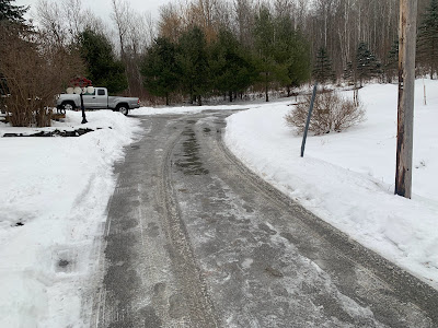
Parts of my St. Albans, Vermont driveway thawed today,
while other parts remained solidly frozen. A cold
rain tonight will likely add to the ice, despite
temperatures expected to be marginally above freezing

Forecast rainfall amounts have also ticked up since this morning. That makes me wonder whether power outages will be an issue in parts of eastern Vermont.  I don't think it will be anywhere near as extensive as during those awful wind storms on January 10 and 13. 

But a quarter inch of ice accumulation is where tree branches and power lines start to have trouble. Some areas in eastern Vermont will have that much. 

On the bright side, widespread power outages usually don't start happening unless there's more than a half inch of ice, and that isn't in the forecast through Thursday morning. 

In western Vermont, enough cold air might bleed in from the north tonight to make parts of Franklin County pretty icy.  Even if it stays above freezing, the rain will freeze on cold surfaces that aren't treated with salt. I'm talking back roads, driveways, sidewalks, that sort of thing.

I noticed today at my place in St Albans, Vermont, parts of my driveway thawed, while the ice has hung on stubbornly in other sections. We don't salt our driveway, because that would hurt the paws of Jackson the Weather Dog. My driveway is just an example of how things will play out tonight. 

THURSDAY 

Another lousy day in Vermont. The main batch of rain and freezing rain will move out by dawn or shortly thereafter.

That will leave us under a layer of low, thick clouds. We'll have areas of fog and patchy drizzle and freezing drizzle. If you have Seasonal Affective Disorder,  this will be another tough one. 

Especially since another round of rain and freezing rain will be on our doorstep. 

THURSDAY NIGHT/FRIDAY

That will come in overnight Thursday night and last well into Friday.  I suspect the freezing rain won't be quite as widespread as tonight but that's not a guarantee. I still worry about a few places that don't thaw out Thursday, then get more freezing rain Friday.

Friday will be another day of low clouds, fog, drizzle and light rain and/or freezing rain. In some placed all that will keep freezing.  Where it remains above freezing it'll only be in the mid 30s. That's quite warm for this time of year, but bone chilling given the fog and drizzle.

BEYOND FRIDAY

It'll stay mild Saturday and maybe into Sunday, but the clouds will hang tough. We're still watching yet another storm later Sunday. So far, it's still looking like that one will stay too far south to give us much precipitation. Even if it does, the atmosphere will have cooled enough to give us snow, not freezing rain. 

Cross your fingers but longer range forecasts indicate we just might have a quiet weather week next week. Sometimes boring weather is a good thing.