Showing posts with label flash freeze. Show all posts

Wednesday, February 28, 2024

Quick Wednesday Evening Storm Update: Few Changes, Blast On Our Doorstep

Strong south winds in St. Albans Bay today was causing 
a slight "ice shove." The wind was pushing ice
up the bank toward the park above the lake. 
Quick Vermont storm update this late Wednesday afternoon. 

It's gotten awfully dark out there as of 4 p.m. this afternoon and the south wind has picked up as the big promised cold front bears down on us.  

We did manage another record high in Burlington today as it reached at least 60 degrees so far, besting the record of 59 degrees in 2018. 

 It might go up another degree or two, as sometimes an approaching cold front compresses the air, heating it a bit. 

It still looks like it will enter western Vermont a little after 6 p.m. and quickly move through. 

There have been some little changes to the forecast.

Most notably, the flood watch has been dropped. 

Expected showers during the day under were pretty underwhelming, so we missed out on that runoff.  The downpours with the front shouldn't be enough to cause much in the way of flooding. Rivers will still rise, but most should stay at or  just below bankful 

Winds will remain gusty from the south until the front hits.  Some favored areas in the Champlain Valley are gusting over 40 mph and that will continue for a couple more hours. 

When the front arrives, the wind will pick up from the west. Some of the taller showers with this front might be able to grab some high speed air from aloft and bring it to the surface. That'll be hit and miss.  

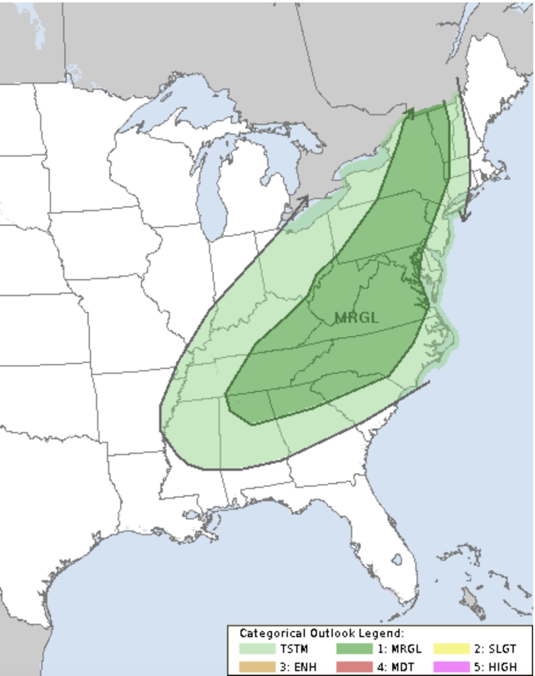
The western half of Vermont still is under a marginal risk for severe storms, because of those possible wind gusts. That's the lowest risk level on a five point scale.  As of 4:15 p.m., I am seeing a line of scattered lightning strikes near Ottawa, Canada and a couple more near Watertown, New York. 

So there might be an isolated lightning flash or two or a rumble of thunder when this comes through in the next few hours. But nothing to really light up the skies. 

Behind the front, wind gusts will continue. The highest winds might actually come about an hour after the front goes through. By that point, says the National Weather Service, the atmosphere will be able to mix some higher speed winds to the surface. 

So, the wind advisory remains in effect through the night. 

A flash freeze later tonight is still in the cards, too. Nothing has changed with that aspect of the forecast. Expect some slick spots on the roads Thursday morning. Many of us will probably see a little snow at the tail end of this event, but it won't amount to much. 

You can see how fast it gets cold behind the front by looking at reports from western New York. Buffalo, New York was at 64 degrees at noon, but down to 45 at 1 p.m. By 4 p.m., it was 33 and snowing in Buffalo. 

Watertown, New York was at 61 degrees at 3 p.m. and 45 at 4 p.m. So it's coming, folks!

It's still looking blustery and cold tomorrow. 

I'll leave it at that and I'll see how we did with this in the morning with a new report here in this blog thingy.  

Heat And Wind And Rain And Thunder And Snow: February In Vermont

Buds on a lilac bush on my St. Albans, Vermont 
property already beginning to swell at the end
of February amid record warmth. Some of the lawn
looks suspiciously green, too. 
It never got below 50 degrees in Burlington, Vermont last night, meaning it was a typical overnight for late May. 

The weather keeps running off the rails after yesterday's record warmth.   The character of it changes today, before things get wild this evening. 

Tuesday was a delightful, sunny spring day in the Green Mountain State, never mind that it's February. The record high of 65 in Burlington would have been normal for May 5, the time of year when flowers and buds are bursting into green.

Of course, a lot of plants in local gardens are starting to poke up, which is way too early.

Record highs are inevitable today. By 8 a.m. today, Burlington was already up to 56 degrees, just three degree shy of the record high for the date. 

A burst of rain showers might or might not delay the inevitable record high, but a break in the rain this afternoon should ensure record highs once again across Vermont.  Burlington should get into the 60s for the second day in a row, and might even exceed Tuesday's ridiculous high temperature. Temperatures in the 50s will be widespread in "cooler" areas of the sate. 

You should see south winds picking up through the day, too, as that powerful cold front approaches this evening. By afternoon, winds will be gusting to 40 or even 50 mph in some spots.  

A wind advisory kicks in across Vermont at 1 p.m today and lasts until 7 a.m. Thursday. That covers the gusty south winds ahead of our big cold front, the gusts along the front and the rushes of wind behind the front as the cold air works in. 

Drama Hour

The drama should really hit when the cold front comes through. It still looks like it will arrive roughly at 6 p.m give or take in the Champlain Valley, and 7 p.m. or a little after  in eastern Vermont. Again, give or take. 

NOAA's Storm Prediction Center still 
has much of Vermont and the eastern
U.S. in a marginal risk zone for
severe thunderstorms today. 

The front will bring a narrow band of torrential rains and possible thunderstorms, and a big surge of wind. 

NOAA's Storm Prediction Center still has most of Vermont under a marginal risk of severe thunderstorms with this. Some bursts of winds with this could be damaging. You might see little or  no lightning with these storms, so they'll mean business.

You might want to stay off the roads as this comes through due to the blinding rain and gusts of wind. Or at least take it easy. 

The flood watch remains in effect, too, mostly along and west of the Green Mountains. The combination of rapid snowmelt from the mountains today and those downpours along the cold front should get rivers rising pretty fast. 

It'll be a minor flood, but still, watch out this evening and overnight for water on low-lying roads, and in urban areas during and just after the evening downpours.

This time, it won't be a disaster. Downtown Montpelier, Johnson and other flood-prone communities are pretty safe this time, except for those low elevation roads near rivers. Some steep back roads could suffer some erosion. And if there are any culverts still clogged by ice, that could cause a couple problems, too   

Spring Ends Temporarily 

Behind the front, we'll see rapidly falling temperatures and still some strong, gusty west winds. By late this evening, it'll start to go below freezing. It doesn't look like there will be much snow at the tail end of this. Maybe a half inch in the valleys, an inch or two in the mountains.

But that water will freeze hard and fast, especially since temperatures will crash into the teens by dawn or earlier. You'll be dealing with icy sidewalks and untreated roadways and driveways tomorrow morning, that's for sure. 

For just one day Thursday, we'll have winter weather with sunshine, temperatures holding near 20 all day with gusty winds keeping wind chills near zero. Then that ends as quickly as it began. 

Spring Comes Back

The oddly warm weather we've had all winter comes back to make March come in like a lamb. Sure, it'll be chilly at dawn, Friday, March 1. But it will be in the 40s by afternoon. After that, it looks like much of Vermont will see a good five consecutive days with highs in the 50s - very warm and very strange for early March.  

Tuesday, February 27, 2024

After Record-Shattering Warmth Today, Vermont In For A Wild, Stormy Ride

Go back! Lots of daffodil shoots and other green plants
were coming up today in my St. Albans, Vermont 
gardens amid record warmth. In February. 
 As you might have noticed, the warmth in most of Vermont really over-performed today, as record highs were shattered by wide margins. 

Burlington got up to 65 degrees, blasting past the old record for the date of 57 set in 2000.

 In nearby St. Albans, I found myself doing outdoor yard chores comfortably dressed in shorts and a sleeveless t-shirt. 

Other record highs  today included 55 in Montpelier and 54 in Plattsburgh.  

The wild storm due tomorrow seems wilder than earlier forecasts, judging from forecasts issued this afternoon. There are a bunch of weather alerts, watches, prognostications of other hazards and some pretty extreme changes in the weather. 

Let's take the hazards one at a time, though a lot of these problems will be intertwined. 

High Winds

Virtually all if Vermont is under either a high wind watch or a wind advisory for Wednesday afternoon and evening.  Southern Vermont, and the eastern slopes of the Green Mountains into central Vermont, are under a high wind watch from early afternoon well into the evening. 

Although some damaging wind gusts - up to 60 mph - could occur before the storm's powerful cold front comes through Wednesday evening, most of these gusts in the high wind watch area will hit along and just after the front comes through. 

Elsewhere in Vermont, a wind advisory is up from Wednesday afternoon through early Thursday morning.  Once again, some of the strong gusts could come through in the warm air ahead of the cold front, but the worst of it will be along the cold front and in the rapidly chilling air behind it. Gusts could reach 55 mph. 

This won't be as destructive as the two big wind storms in January, but we'll deal with some tree damage and scattered power outages with this one.

Thunderstorms

A real rarity for February: A low, but not
zero risk of severe thunderstorms in the 
Northeast, including Vermont. Severe
storms possible in darker green shading on map.
We could see some thunderstorms during the morning or early afternoon, but that's iffy. 

The real trouble would be just ahead and along the cold front Wednesday evening. NOAA's Storm Prediction Center actually has us under a marginal risk for severe thunderstorms Wednesday, which is extremely rare for February.   

The only time I can remember Vermont being under my kind of severe thunderstorm risk in February was at the tail end of record February warmth in 2017.

True, a marginal risk is the lowest level of five risk levels, but still that's something. This will probably take the form of a narrow line of strong storms sweeping west to east across Vermont as the cold front plows through. 

There will probably be only a little lightning, or maybe none at all in many places, but these storms will mean business. 

Flooding

A flood watch has been hoisted for all of Vermont. Rainfall won't be all that extreme -  running from a half inch to a little over an inch. 

However, most of it will come in heavy downpours in the late afternoon and evening. Plus, there's snow melt. There actually is some snow in the mid and high elevations. Today's warmth "primed" the snow for melting.

Warmth, and a high humidity for this time of year will really melt that snow super fast Wednesday afternoon before the cold air hits. The combination of the snowmelt from the mountains and the rain should make rivers rise pretty fast Wednesday evening and night. 

The rivers to watch in Vermont are mostly the Otter Creek in Rutland County, and the Mad River in central Vermont which could hit minor flood stage. 

This won't be as bad as the flooding we had in December, but look out for high water on low lying roads, ponding and urban street flooding during and just after the evening downpours and some washouts on back roads.

Record Warmth

Given how much warmer it got today than forecast, I see that meteorologists are now pretty bullish on record heat on Wednesday.  It still looks like there might be a lull in the showers during the afternoon. 

Even though it will be much cloudier Wednesday than today, the atmosphere will actually hold more heat than this afternoon. The result: More highs in the upper 50s to mid 60s are definitely possible. That will shatter more records. 

Snow/Flash Freeze/Wind Chills

We're still looking at an incredible temperature crash after the cold front goes through. Since this is part of such a dynamic storm systems, we'll see a rapid change over to snow - probably within three hours after the cold front blasts through.  There might be a brief period of heavy, wet snow, maybe even isolated thunder snow. Then the snow will rapidly taper off to fluffy flurries.

As temperatures crash, much of the day's rain and that possible burst of wet snow will freeze. So by later Wednesday night and overnight Thursday, the roads will probably turn awful in a hurry. There still should be a "hangover" of slick roads even by the time the Thursday morning commute rolls around. 

Skies will rapidly clear Thursday, but it will be a truly winter day - the last we'll have for quite awhile, as it looks. After getting down to within a few degrees of 10 above in the morning, it will barely make it to the low 20s in the afternoon, if that. The wind will continue to blow hard, gusting to 35 mph or more in a few spots. Expect wind chills near 0.

That will certainly be a shock to the system after today.  But we're still looking at more spring weather starting over the weekend. 

Sure, tomorrow and tomorrow night's weather will be a bit challenging in Vermont, but nothing like other parts of the nation.  

For instance, there's a 0 percent chance of flaming tumbleweeds racing across  Vermont roads tomorrow. That's not the case in parts of Texas, where wildfires amid winds over 60 mph have caused evacuations and property damage.

Meanwhile, parts of Illinois, including Chicago, and other areas of the Midwest are bracing for giant hail and possible tornadoes overnight. 


Wild Record High Temperatures In Nation; Spreads To Vermont Today. Plus: Stormy Weather

One of my perennial gardens in St. Albans, Vermont
this morning. It looked almost exactly like this at
the end of March last year. It bloomed prematurely
last year, so I wonder what the expected near 
record temperatures this week and next will do to it. 
 
UPDATE NOON TUESDAY

Baby, it's hot outside

As of noon, Burlington, Vermont had already broken the record high for the date of 59 degrees.

The old record was 57 degrees in 2000.

It's insane out there, to be honest. Temperatures will probably rise a few more degrees. We have decent chance of seeing the third hottest February day on record. 

The only warmer February days in Burlington were recent: 72 degrees on February 25, 2017 and 69 degrees on
February 21, 2018. 

Before 2017, the warmest it had ever gotten during February was 62 degrees.

The sights I'm seeing out there seem strange for February, too. Motorcycles are buzzing along highways. Trucks with trailers are hauling ice fishing shanties away from the lakes. 

There's actually a brush fire risk out there. It's windy, especially in the Champlain Valley, where there is no snow.  I wouldn't be surprised to see reports of grass or forest fires in low elevations today. In February!! 

I'm glad I burned my brush pile last week when there was a little snow on the ground. 

Skies were mostly clear at noon, but there was a hint of wildfire smoke up above. Another strange sight for February. The smoke is coming from a few wildfires in the South earlier this week.  There's also some large wildfires in the Great Plains, and we might eventually see a little smoke or haze in the sky 
from that. Either from this heat wave or another one scheduled for the weekend and early next week

PREVIOUS DISCUSSION

I was pretty much in awe of record highs temperature reports from the middle of the United States yesterday. 

This ain't your grandfather's February, that's for sure. 

Those record highs extended from Texas to near the Canadian border.  

At least 33 weather stations reported all-time record highs for the entire month of February.  Among them were 78 degrees in Des Moines, Iowa; 80 degrees in Omaha, Nebraska; 73 in Rockford, Illinois and 65 in Minneapolis.

At least six cities in Iowa reported all time record highs for February.

Dozens upon dozens of other cities reported record highs for the date on Monday. The hot windy weather spurred several major rangeland and wildfires in Texas, Oklahoma, Nebraska and Kansas. 

The warm state of affairs continues today with more record highs expected in the Midwest and Northeast, possibly even here in Vermont. 

The record high for today in Burlington is 57 degrees and in Montpelier, it's 52. Both seem reachable today. 

Plus, we still have plenty of excitement in the Vermont forecast, including more record highs tomorrow, a little bit of flooding, strong winds, a huge crash in temperatures tomorrow night followed by another big warmup. 

Never a dull moment so let's get into it:

TODAY

Speaking of weird temperatures, we started the day out with some craziness. Some spots at dawn were warm, others chilly.  For instance, it was 41 degrees in Burlington at 7 a.m. but just 23 degrees in Montpelier. 

Burlington was exposed to increasing south winds while Montpelier was sheltered from those winds.

Temperatures will even out today and soar into the 50s amid gusty south winds and a fair amount of sunshine.  Essentially, we have a breezy late April day in store, even though it is only February. Go figure. 

It'll stay warm tonight - well above freezing - and some showers should move in late. Nothing heavy, though. The winds will continue to blow.

WEDNESDAY/WEDNESDAY NIGHT

We're still expecting quite a lot of weather excitement tomorrow and tomorrow night around Vermont, as the forecasts issued yesterday haven't changed all that much. 

Expect lots of wind and warmth during Wednesday, with mostly light showers around. It still looks like there might be a lull in the showers during the afternoon. That could allow temperatures to really soar into the 60s if it stops raining long enough and if there are thin spots in the overcast.

In some favored locations the south winds in the afternoon could gust to 45 mph, which might cause a few little problems with tree branches and isolated power outages. 

That's still iffy, so we'll have to wait and see how that plays out. 

The sharp cold front will plow into Vermont Wednesday evening. Best guess on the timing is at around 7 p.m. or so west of the Green Mountains and 8 or 9 east.  (That timing could easily change one way or another).

The cold front will produce a burst of heavy rain and a blast of westerly wind gusts that could gust to 50 mph.  The snow that would have been melting off the mountains Wednesday, combined with the rain, still looks like it might produce minor flooding along some rivers. Or at least get them up to bank full. 

At this point, the rivers with the best chance of reaching flood stage appear to be the Otter Creek in Rutland County and the Mad River in central Vermont. 

While this potential high water will be going on Wednesday night, temperatures still look like they will absolutely crash. For instance, the National Weather Service has Burlington going from 56 degrees at 7 p.m. Wednesday to 20 degrees by 4 a.m. Thursday. 

There will only be a wee bit of snow at the tail end of this, but with the bottom dropping out of the temperatures overnight, expect water on roads and sidewalks to freeze solid by Thursday morning. Watch it on the roads and on the sidewalks if you're out early Thursday. 

THURSDAY AND BEYOND

A very quicky cold, blustery day on Thursday, but at least the sun will be back out. That's it for cold, though. A chilly Friday morning will yield to a fairly warm afternoon. The weekend and early next week bring us back to normal April weather, which of course is very weird for the beginning of March.

I hope that doesn't mean we get a series of snowstorms in late April! Or during the April 8 eclipse!  

Friday, December 23, 2022

Storm Blasting Vermont Now, Lots More To Go Before It's Over

The Arctic front coming in from the southwest to give
Vermont a flash freeze this afternoon is seen here 
approaching Frederick, Maryland at 8:30 a.m. today.
Before the front gets to Vermont, expect 
several more hours of damaging winds. 
UPDATE 11 a.m

A pretty shocking 70,600 customers were without power at this hour, which is a wild number.

Amid all the wind, a LOT of pictures of blue sky and rainbows popped up on social media.

Downslope winds are just that, going down. Sinking air destroys clouds, which is mostly why the sun broke out, especially west of the Green Mountains.

Wind has abated somewhat, but strong gusts are still a risk for the remainder of the day. Before and after the Arctic air arrives.

Though 70 mph gusts are still possible, but becoming less likely. Gusts over 50 mph are still very much in play for the rest of the day.

Interestingly, the highest wind gust reported so far was that 70 mph in Burlington. This is a particularly strong storm with winds aloft screaming harder and faster than has almost ever seen before. So it stands to reason that the downslope winds might have more of an angle away from the immediate slopes at times and further into the Champlain Valley instead.

Numerous roads are closed by fallen trees and wires, so be wary of that. It will take a lot of time to clean up the mess.  
This image of tree damage posted by Green Mountain Power
is just one example of widespread troubles from
today's storm in Vermont.


Flooding is now in play and will continue and perhaps worsen this afternoon.  A flood warning is up for much of the Champlain Valley and central and southern Vermont. 

Around a 1.5 inches of rain has fallen in some areas, with a half inch to an inch more on the way. Plus there's all that melting snow. It's another reason to stay home. 

You might encounter flooding in low spots. 

The flash freeze is still on schedule for the afternoon, which is a huge hazard as roads will turn to glare ice. Gov Phil Scott is sending most state workers home by 1 p.m. in anticipation of the freeze, and he is encouraging other Vermont employers to do the same. 


"'You need to be where you are going to be by 4 p.m.,' said Public Safety Commissioner Jennifer Morrison. "After that, all bets are off and you will be taking a tremendous risk.'"

UPDATE 9 a.m.: A 70 mph wind gusts was just reported at the National Weather Service office in South Burlington. That ties the record for the second highest wind gust on record in Burlington.

This is serious folks!

PREVIOUS DISCUSSION 

As of 8 a.m. we in Vermont were well into the wind phase of this huge storm. 

Power outages are ramping up rapidly, damage reports are starting to come in pretty rapidly now, and winds are howling. 

As is the case in most downslope events, the gusts come sporadically. Some neighborhoods seem relatively protected from the wind and aren't that bad. Other neighborhoods get blasted every few minute by damaging gusts, with lulls in between.

Reports of actual gusts are just starting to come in. We'll see more of those later

As of 8 a.m, VtOutages.org, nearly 29,000 Vermont customers were without power. That was up from just 4,700 outages as of around 4 a.m.  By 8:30, power outages were  up to 38,500, and rising super fast. 

So far, the damage reports are coming mostly from towns that are most prone to downslope winds on the western slopes of the Green Mountains. Wells, a perennial downslope wind epicenter, reports multiple trees own along Route 30 in that town.  A number of trees were down along Browns Trace Road in Jericho. 

Traffic issues will get worse as major roads are affected. As of 8 a.m. for example, Route 7 near Route 17 in New Haven was shut down by fallen trees and power lines. Earlier, Route 5 in Norwich near the intersection of Route 132 was shut down for the same reason.

We'll see more and more examples of this as the morning wears on. 

Storm chaser Nishan Bilazarian has been in the storm around Mendon and Rutland, Vermont overnight and this morning. Video shows his vehicle rocking in the wind,  and traffic signals in Rutland swaying mightily in the gale. Before dawn, he reports power flashes from breaking power lines around Rutland. 

Many of you are probably hearing a sound akin to jet engines outside. That's the sound of winds as high as 100 mph a few thousand feet overhead.  Most of it stays up there, but especially in western Vermont, the wind breaks like a wave over the mountains, and in that fashion is able to roar down the slopes of the mountains as powerful, damaging gusts. 

The strongest winds today should happen between about now, 8 a.m. and 1 p.m. 

Of course, I'll have trouble keeping up with the reports, but you get the idea from the above description. I'd stay home at least until the winds die down.

The highest wind period, through 1 p.m., isn't the end of it. The powerful cold front with this storm passes through this afternoon.

Ahead of it, in addition to the wind, we'll see waves of rain pass through.  

The National Weather Service in South Burlington says the front is so powerful, things might get a little weird as it passes through.

For instance, the sharp drop in temperature will probably occur a few thousand feet aloft a little before the blast of frigid air reaches us on the ground. That cold air aloft could allow a quick burst of snow and sleet while temperatures are still up in the 40s. You might even hear thunder. (There were already a few lightning strikes early this morning in southeastern Vermont).

Then, the cold air will arrive here. The forecast hasn't changed in that regard. Look for roads to rapidly ice up from west to east, or southwest to northeast this afternoon.

Snow and sleet accumulation will only amount to an inch or less for most of us, but that will just add to the icy conditions. Winds will continue to gust to 50 mph in many areas into the evening. That will make repairing power outages that much more difficult, and possibly lead to a few new ones. 

As temperatures crash into the teens, that will just make things more miserable for repair crews, and people who have no power in their homes.


Thursday, December 22, 2022

Vermont Storm Set To Hit Tonight, Cause Havoc Into Saturday

I won't be in Vermont for the big blow. This is the view out
my plane window approaching JFK before dawn today. 
Remember what they say: Red sky in the morning,
sailer take warning. That strip of red sky on the 
eastern horizon was one hint that the eastern United
States, including Vermont, will have quite
a rough weather Friday.
As of Thursday evening, the forecast for a damaging and dangerous, big and multifaceted storm in Vermont is unchanged, so batten down the hatches. 

I'll get to a detailed forecast in a sec, but there is also additional news as everybody in Vermont gets ready for this big tempest.

In anticipation of widespread power outages and plunging temperatures Friday night, Vermont Emergency Management says local shelters and warming centers are being set up. They said to check out vermont211.org for options if you need them.  

Vermont Agency of Transportation announced Thursday that Amtrak is suspending service in Vermont on Friday. This is both the Vermonter and Ethan Allen Express. Apparently, Amtrak came to the sensible conclusion that they really don't want their trains smacking into trees that will have fallen across the tracks. 

Green Mountain Power says they have an army of people ready to work on restoring power from the winds. But restoration might not necessarily be that fast. It will be hard to make repairs while the wind is still roaring due to flying debris and other falling trees and branches near work sites.

Charge your devices now, get bottled water ready, along with LED candles and headlamps if you have them. I wouldn't use regular flame candles. They're a fire hazard.

Another hint: If you have 5 gallon buckets or something like that, fill them with water now. You might not be able to properly flush your toilet without electricity because fresh water won't be pumped into the tank after the first flush. 

You can use those five gallon buckets of water to accomplish this. Hey, as far as I'm concerned, working toilets are important.

Those of you have Christmas decorations outside, especially some that can get blown away easily, should consider taking them in this evening and putting them back out on Christmas Eve when the wind is starting to die down. 

Flying debris of any kind can damage property in wind storms. Do you really want your Rudolph the Red Nose Reindeer statue bashing in the vinyl siding on your neighbor's house?

Given the risk of debris on the roads from the wind, flooding, and the flash freeze coming later in the day, it's probably best to postpone travel plans until Saturday.

Saturday won't be great, as icy patches will linger and it will be quite windy and cold, but at least it won't be nearly as scary on the roads as Friday.

THE FORECAST DETAILS:

Slush and Mush:

A winter weather advisory is up for a good part of tonight for higher elevations of southern and central Vermont. Wet snow and mixed precipitation will dominate the start of the storm tonight.  Valleys will have mostly rain, but some snow mixed in for a time.

Heavy wet snow of two to six inches will make things worse in some high elevations when the high winds arrive later on. Timing of this mix is overnight and the wee early morning hours of Friday.

Then The Wind

The wind, of course, will be the headline feature of this storm. The gusts will rapidly increase, especially after midnight. We were already starting to pick up a southeast breeze in Bennington and Rutland as of 4 p.m. You'll see that increase down there as the evening and overnight wears on.

The worst winds should come through from about 3 a.m. to about early afternoon, then slowly tapering off. 

This is a high end event, possibly among the top five worst wind storms on record in Vermont. Forecasters are still worried that the downslope winds off the Green Mountains will extend well west of those mountains. This could prompt 70 mph or more gusts in places like Rutland, Middlebury, and possibly Burlington and St. Albans.

Not everybody in western Vermont will see such ferocious gusts. Those super powerful winds  will be kind of localized. But pretty much everybody can expect gusts to 50 mph at the very least.

The worst hit areas will see wind gusts reaching or exceeding hurricane force. I still wouldn't be surprised to find the usual suspects - the places that usually see the strongest downslope winds - reach 90 mph.

Candidates for that kind of blow would be places like Wells, Mendon, Ripton, Hanksville, Huntington, Underhill and Cambridge.

We know there will be quite a few power outages and tree damage.  I worry about trees in forested neighborhoods crashing onto or through homes. At the very least, I picture roofing shingles littering a lot of lawns and streets by afternoon. 

The high wind warning covers all of Vermont except the southeast and Grand Isle County 

Where winds are "lighter" they could still gust to 50 or even 60 mph, mainly east of the Greens. That's still enough to cause some tree and power line damage.

Note that after winds "subside" they'll still gust to 50 mph or even a little more in some areas into Friday night, well after the storm starts to depart.

Flooding

Periods of rain and melting snow in the morning, plus a burst of heavy rain ahead of and along the storm's cold front still puts us at risk for some mostly minor flooding. Street flooding, small creeks and probably the Mad River and Otter Creek still look like a fairly decent bet.  Note that much of the flooding will take place while temperatures are crashing towards and below freezing later in the day.

Flash Freeze

That's still very much in play, too. As the powerful cold front moves through, rain will become heavier, and as temperatures plunge we might get a quick period of sleet, then perhaps a brief snow. In any event, all that water around will ice up quickly.  If it snows a bit while temperatures are dipping below freezing, that will make things all the more dicey on the roads. 

It's not certain, but there could even be a little thunder thrown in. The timing of this drop in temperature will be early afternoon to late afternoon depending on where you are.

Note that this weird cold front will move from southwest to northeast. There probably will be a weird moment in which normally mild Bennington already has their teeth chattering in the cold, while normally frost Newport up in the Northeast Kingdom is still enjoying balmy breezes. Or gales, whatever the case might be.

After That

It will be a cold and blustery Christmas weekend, but not as bad as further west in the nation. The Arctic air has been plunging south, toward Texas and the Gulf Coast.  It will have to turn the corner and move toward the northeast to reach us. (Remember that cold front Friday that will move from southwest to northeast).

The detour the cold air will make will give it a chance to modify, to warm up.  Yeah, it'll still be cold, with highs in the teens to around 20 Christmas Eve and barely around the low 20s on Christmas Day. Nights will get into the single numbers and teens, and wind chills will be below zero.

But that's really not a big deal for winter-hardy Vermonters, unless the power is out at your house. And this expected weekend weather isn't nearly as bad as the teens, 20s 30s and even low 40s below zero readings found today and tomorrow in the eastern Rockies and northern Plains.

Wednesday, December 21, 2022

Early Thursday Update: Worrisome Wind Forecasts For Much Of Vermont

Updated wind forecast issued Wednesday afternoon. Peak
gusts for Burlington and St. Albans might be under-done
a bit. But note the 74 mph expected gusts in Rutland. 
UPDATE: 8:30 AM

I'm able to update this post, which I first wrote at 2 p.m. today.  In my travels, I'm waiting for a connection to Baltimore from JFK. 

Not much updating needs to be done to the previous discussion, below.  

The wind threat remains very, very real.  To the point where I see storm chasers appear to be on their way to Vermont to see the show Friday. 

Anytime storm chasers take an interest in your state, you know you have trouble.

One added piece of danger. It looks like some of the higher elevations could have two to six inches of wet snow tonight before the changeover to rain.

Some of that wet snow could still be clinging to trees when the howling winds arrive later Thursday night. That would only compound the inevitable power outage issues. 

The only other additions I'd make for now to what I wrote below is the powerful cold front that will sweep through Vermont will have its own batch of interesting weather. As if there wasn't enough of that already.

We already know temperatures will crash with the passage of the front, yielding to that vaunted flash freeze.  According to the National Weather Service, the front could be so dynamic that we could have thunder, torrential rain, heavy sleet and possibly a quick burst of snow toward the end.

Previous discussion follows, which is worth the read, as it's got some important info:

PREVIOUS DISCUSSION

Unfortunately, if current forecasts are true, the upcoming storm might be among the worst wind storms Vermont has seen in decades. 

According to forecasts issued last night and early this morning, the biggest worry spot is the Champlain Valley. 

Meteorologists have known for days that downslope winds on the western slopes of the Green Mountains would become ferocious on Friday morning. In favored spots right near the mountains, winds could gust to 70 or 80 mph or more.

That's bad, and would cause some damage, but it's happened before. This region is fairly sparsely populated, and the people who do live in this region have some experience with such powerful gusts. However, it's looking like the damaging winds might well  extend much further west into the Champlain Valley. 

Here's an excerpt from the forecast discussion from National Weather Service office in South Burlington, issued late Wednesday afternoon:

"Peak gusts comparable to a category 1 hurricane are forecast in the western slopes of the Green Mountains. We're increasingly concerned by the likelihood of populated areas well away from the mountains, including the populated Champlain Valley towns in Chittenden and Addison  counties, not accustomed to seeing winds of this magnitude."

This translates to winds gusting to more than 65 mph in these populated areas. It's not out of the question winds in the Route 7 corridor could reach 75 mph.  For comparison's sake the strongest wind gust ever measured in Burlington since at least 1900 was 72 mph. 

This could well be one of the worst wind storms in history, at least in the western half of Vermont. "Multiple long time forecasters have not seen winds at this pressure level at this magnitude in our region," the Wednesday evening forecast discussion stated, ominously."

The winds are forecast to ramp up quickly late Thursday night and early Friday and peak during the early to mid afternoon. 

According to the high wind warning that's been issued: "People should avoid being outside in forested areas and around trees and branches. If possible, remain in the lower levels of your home during the windstorm, and avoid windows."

What worries me the most is those many neighborhoods in the Champlain Valley that have lots and lots of trees. Some of those trees seem like they might crash onto or through some of those houses. This is dangerous!

I'd also expect some long lasting power outages in the worst hit areas.

Green Mountain Power announced Wednesday that they were able to keep a lot of the crews that came from out of state to deal with last weekend's massive snowy power outages here in Vermont to deal with this new storm. 

Despite the big crews ready to help with outages, GMP urged customers to be prepared for real trouble:

"With cold temperatures forecasted, customers should have a plan for where to go if they need to leave their home and how they would get there. With extreme high winds, there can also be hazards like flying debris that can make it unsafe for anyone outside, including crews." 

It's a tricky forecast, so it's still possible the wind could under-perform in western Vermont. But definitely don't count on that! The wind doesn't look like it will be as bad in eastern Vermont, but some tree damage and power outages seem likely even there.

The wind is obviously the biggest danger from this storm, but we continue to watch other issues:

 INITIAL ICE

Forecasts have trended a little colder with the onset of the storm. That means some places might receive a couple inches of snow, and some other areas will see some sleet and freezing rain. This will be a problem for anybody on the roads overnight Thursday. Rapid warming early Friday morning will erase this hazard.

FLOODING

This is still a real issue. The storm's powerful cold front will produce a period of heavy rain. Right ahead or along the cold front, a narrow band of torrential rain, similar to a summer squall line, seems possible.

Total rainfall looks like it will be in the one to two inch range, with higher amounts in some spots Combine that with rapidly melting snow, and you have a real problem.  A flood watch is up for much of Vermont, especially central sections of the state. 

River forecasts have gotten more detailed with updates. The Mad River at Moretown is expected to come close to moderate flood stage. Many if not most other rivers in Vermont will probably reach minor flood stage.

I'm especially worried about some of the smaller rivers in southern Vermont. The heaviest rain is expected to fall there, and the deepest snow from last weekend also accumulated there.

FLASH FREEZE 

The anticipated flash freeze is still on. With the cold front, temperatures will crash from the low 50s to the 20s in a matter of as little as two hours.

The freeze looks like it wants to come just a bit earlier than first forecast - probably late afternoon.

Roads will freeze instantaneously.  We also expect a brief period of freezing rain, sleet and snow as the temperatures plunge. 

BOTTOM LINE

If forecasts hold, this could be an historic storm for Vermont, comparable to the Great Appalachian Storm of 1950.  Hang onto your hats! 

Friday, February 18, 2022

As Expected, Messy Icy Morning In Vermont; Ice, Wind, Power Outages, Flash Freeze

Interstate 89 at the bridge over the Lamoille River in 
Milton didn't look so great after the flash freeze early this 
morning. You can also see water levels starting to
rise and crack the ice in the river beneath the bridge.
 As we anticipated, it was a messy overnight in Vermont and it continues to be a messy one this morning. 

By the way, we have more "interesting" weather coming up tomorrow, and early next week. We'll get to that in a bit. 

First, let's deal with this morning. 

At dawn, a sharp cold front was almost finished clearing Vermont. It was still warm in Springfield and Bennington, but that will have changed very soon.

It's a bit deceptive out there at first glance. Where you are, it might not be snowing very hard, but the flash freeze did its job. We had lots of standing water from the rain last night, and then temperatures crashed.

The roads this morning are atrocious, so is everything underfoot.   Take lots of extra time if you're driving anywhere this morning. We have tons of school closures and/or delayed openings today because of the weather. Chances are your kids' schools are affected, so keep that in mind. 

As of 7:30 a.m. power was out to about  5,000 Vermont homes and businesses, mostly in southern Vermont. Winds gusted this morning to 45 mph in Montpelier and 52 mph in Bennington, and I'm sure other places in central and southern Vermont had stronger gusts than that early today. 

The cold front's squall line extended southward from Vermont through southern New England, southern New York and New Jersey, causing a lot of wind damage and power outages in all those areas. 

Even though temperatures either have dropped or are dropping sharply, there's still a flood threat from the runoff of last night's heavy showers. Ice jams can still form, too. 

River gauges on the Mad River at Moretown have been fluctuating a lot early this morning, indicating there's probably issues with ice jams anywhere between Warren and Moretown, so a flood warning was in effect in that area. 

In New York's Adirondacks, the Ausable River was rising rapidly early this morning.  I wouldn't be the least bit surprise if other flood warnings or advisories pop up this morning in Vermont and New York. 

How things played out last night was very close to what the National Weather Service in South Burlington had warned us about, so kudos to them. 

It was still interesting. The sharp cold front swept down into the Champlain Valley a little before midnight, then stalled in Addison County, and along the west slopes of the Green Mountains all the way to the Canadian border.

At Burlington, it was 50 degrees at 11 p.m. last night then 35 at midnight, then 32 at 1 a.m. As expected, freezing rain and sleet iced things up in most of the Champlain Valley. Also as anticipated, it wasn't enough to wreck the trees and wires. The thickest ice reported so far was at the National Weather Service office in South Burlington, with 0.13 inches.

The cold front stayed put for a few hours, enabling it to be the focus of heavy rain in much of Vermont, but heavy mixed precipitation in the Champlain Valley.

When the storm center moved into northern New Hampshire before dawn, that cold front was finally able to start moving east across Vermont.

The flash freeze spread. At Montpelier, it was 52 degrees at 4 a.m., 34 degrees at 5 a.m. and 28 at 6 a.m.  The change was even more pronounced in Rutland. There, it was a balmy 59 degrees at 4 a.m., but down to 37 by 5 a.m. and 31 by 6 a.m. 

Light snow is falling behind the front in Vermont, but it won't amount to much more.  The sun will actually come out in many areas this afternoon, but it will remain blustery and cold as we try to chip the ice off everything. 

And as noted above, we're not with the interesting weather yet. 

Saturday:

A compact little storm and cold front will come in from the west tomorrow. It has a pretty dynamic cold front with it. Which means scattered areas of Vermont could see some heavy snow squalls with this. Overall accumulations won't be much as most areas will receive one to three inches at most.

But the squalls create brief white out conditions on the roads, and also turn dry pavement into glare ice in a flash. (Again!). So be careful out there tomorrow, and if your area receives a snow squall warning, wait it out, and don't drive anywhere until it passes and road crews get a chance to clean it up. 

Tuesday-Wednesday

A new storm seems to want to get going for us during this time frame.  It will be a similar set up to the one we're just now getting through, with a sharp cold front and a possible mix of precipitation.

This one doesn't look as strong as the one we've experienced overnight, but it does have potential to cause some issues on the roads again. Computer models haven't settled yet on the track of the storm, so it's unclear still if this will be mostly rain, mostly snow, or an ugly mix of snow, rain and ice. Stay tuned! 

Next Friday

Some computer models bring yet another storm through here in a week, as the weather pattern stays active. It's way too soon to know if that storm will actually affect us, and if so, how. It does seem as if the dry pattern we had in January is over, at least for now 


Thursday, February 17, 2022

Gearing Up For A Rough Weather Night In Vermont, As Floods, Winter Storms, Severe Weather Hit Swaths Of Nation

Just one example of the flooding risk in Vermont from 
tonight's rains.  The Otter Creek at Center Rutland is
forecast to crest Friday at moderate flood stage, and
just one foot lower than major flood. 
 As expected today has been a wicked, active weather day in many locations east of the Mississippi River in the United States, and in parts of southeastern Canada.  

Here in Vermont, as of late afternoon we were still waiting for the main show to begin, but it's certainly on its way. We weren't expecting much action until tonight anyway, more on that in a bit. 

As of 4 p.m. tornadoes were beginning to spin in and around Mississippi,  and a nasty winter storm extended from Kansas City to Detroit. 

The main issue with this storm though, is its moisture supply, heavy rain and flooding. Flash flood and flood warnings cover a huge area from southern Missouri, on through parts of Illinois, Kentucky, Indiana, Ohio, western New York and Ontario Canada. As you go north into Michigan, New York and Ontario, ice jams on rivers are added to the mix.

This is all due to a pretty wild moisture feed for this time of year. It's essentially atmospheric river coming from the Gulf of Mexico. The air is pretty much as wet as it's ever been for February, and that has been unleashing some hefty downpours. 

WHAT'S IN IT FOR US?

Here in Vermont, we've only had light rain so far today, and most of that has been confined to areas along and north of Route 2. The rain was starting to fill in a little more as darkness approached, and it will be quite a rainy night.  Or the first part of tonight, anyway, depending upon where you are. 

Flooding

The light rain today prevented northern Vermont from achieving record high temperatures, but the humidity is quite high for this time of year. I've noticed the snow in my yard in St. Albans, Vermont has been melting astonishingly fast this afternoon. That's happening pretty much everywhere in the Green Mountain State, and that is helping to prime the pump for some flooding trouble. 

The unusually wet air will really unleash the rains for awhile tonight, with most places in Vermont expecting over an inch of rain or melted ice and snow. It will be mostly rain for the bulk of the region. 

(I'll get into an ice update in a bit)

This rain, and the snowmelt, has prompted the National Weather Service and the USGS to up their flood forecasts for overnight and Friday. 

Snow was melting off of my St. Albans, Vermont yard
rapidly late this afternoon, but there was still a decent
amount left, More melting will contribute to runoff ad
a flood risk overnight and Friday 

The Otter Creek at Center Rutland is forecast to peak Friday at just one foot below major flood stage. The Mad River at Moretown is also predicted to go into moderate flood, at 2.6 feet above flood stage. The Winooski River at Essex Junction is probably going to go to 1.8 feet above flood stage.

This clearly isn't an Irene-level flood scenario but it's disruptive enough. The usual low-lying roads that flood in the spring probably won't be passable tomorrow.  There will probably be other, smaller waterways that flood, too.

Flooding is harder to see at night, so be careful driving. Don't drive through flooded roads, especially not now. It's dangerous enough in the summer. In the winter, you also have very cold water, which means you'll be paralyzed by the cold water if you fall in, and there will be much less time to rescue you before you drown. 

Ice Jams

Ice jams are the wild card tonight.  Ice jams are what would cause the most sudden, most dire problems, especially if they form in the wrong place. 

Once an ice jam forms, water will quickly back up behind them, essentially causing a frigid flash flood. I would deem ice jams likely tonight. We just don't know where. These jams were already starting to form in rivers like the Ausable in the Adirondacks.  

We've heard reports of the solid ice on Vermont rivers beginning to creak and move late this afternoon. As runoff increases and water rises, it won't take much to set this off. The risk of ice jams starts about now and continues through Friday, even after temperatures crash to well below freezing levels.

Freezing Rain/Sleet

Speaking of crashing temperatures, the forecast hasn't changed much regarding mixed precipitation and ice in the Champlain Valley.

Once the main part of the storm approaches, a shallow north wind will bring subfreezing air later tonight to the lowest elevations. Meanwhile, warm, wet south winds will continue aloft. 

The National Weather Service in South Burlington says at some point late tonight or early tomorrow morning, predictions are for temperatures to be around 27 degrees at elevations of around 1,500 near the Champlain Valley but near 44 degrees at 3,500 feet, a little below the highest summits of the Green Mountains.  

The National Weather Service in South Burlington is thankfully
still forecasting less than a tenth of an inch of ice 
accumulation overnight in northwestern Vermont. That
would spare us from much tree or power line damage

There's a recipe for freezing rain if I ever saw one. It's still unclear what proportion of the stuff coming out of the sky will be freezing rain and how much will be sleet. But it will be a mess, that's for sure. That fun little nightmare should start a little before midnight. 

 
It's still looking like the ice accumulation won't be enough to bring down much in the way of branches and power lines so that's good. Let's hope that forecast holds.  

 In this type of situation, the shallow cold air has trouble making the leap over the Green Mountains, so places along and east of the Green Mountains will only  have a brief period of mixed precipitation when the full force of the sharp cold front comes through before dawn. 

Not much snow will fall at the tail end of this, We're just a little too far east. New York's St. Lawrence Valley is expecting a bunch. But the heaviest snow will fall over the northwest corner of Vermont early tomorrow, and that will only amount to three inches or so. Everyone else gets less, unless we have some weird overnight surprise. 

Flash Freeze

It will be well below freezing by dawn in all but southeastern Vermont, so the forecast from this morning holds. Any water and schmutz will freeze solid, and be difficult to remove from roads, sidewalks, driveways and cars. 

The full force of the cold air will probably hit before dawn for many of us, so at least the flash freeze won't be taking people by surprise as they drive to work.  The damage will have been done for most people by the time the commute starts.

Gusty winds

Once the cold front comes through, we'll have a nice blast of strong northwest winds. Most places are prone to gusts to at least 30 mph.  Southern Vermont is still under a wind advisory as winds could gust to over 50 mph, bringing down scattered branches and power lines early tomorrow. 

Overall, this will be the most challenging storm so far this year, with multiple risks and worries. It won't go down into the annals of history as one of the Worst Storms Ever, but it does need to be taken seriously. 


Messy Storm Still On Track Southern U.S. To Vermont -- Flood, Ice, Freeze, Jams And More

Here's what the National Weather Service in South Burlington
is forecasting for precipitation totals. the northwestern half
of Vermont can expect an inch of rain and melted ice/snow.
 The forecast hasn't changed all that much overnight, so we're still on track for a lousy, messy storm, not only here in Vermont but from the South To Quebec.  

Severe storms and a few tornadoes seem like a good bet in the South today, especially around Mississippi and Tennessee. A long band of flood watches starts in southeastern Missouri and continues on northeastward through Vermont. 

Winter weather advisories and warnings extend in a band just northwest of the flood watches. So the snow and ice is going from Kansas and Missouri through the eastern Great Lakes and nicking northern Vermont and northern Maine. Ontario and Quebec will have winter weather issues later today and tonight, too.

Let's break it down, piece by piece.

FLOODING

As expected, temperatures slowly rose overnight across Vermont and it's above freezing everywhere. More important in terms of snow melt, dew points are also now above freezing, which helps snow melt more efficiently. And some rain was moving in as of dawn.  During the day, most valley locations will have near record highs at least into the low 50s to melt that snow. 

It probably won't rain all that hard today, but it will certainly pick up this evening. Although the rain will change to ice and snow northwest tonight (more on that later) there will be plenty of runoff from melting snow and rain to trigger that statewide flood watch. That flood watch stays in effect from 1 p.m. today through Friday afternoon.

The National Weather Service forecast for ice.  Luckily, it
appears ice accumulation will be mostly less than a tenth of
an inch. So the problem will be terrible roads and sidewalks
and not so much tree and power line damage 
It will be well below freezing by Friday morning, but it will take time for water to drain into the bigger rivers, and ice jams will probably be an issue here and there. 

The Mad River and Otter Creek are forecast to go into minor flood stage tomorrow morning, while most other Vermont rivers will come fairly close to that level. 

The big problem will be those ice jams, which can create a dangerous local flood literally in minutes.  Since the greatest danger of the ice jams will be in the dark of night tonight, you might want to keep your weather radios with you or some other way to alert you if you live in a spot near a river than can jam with ice. 

The ground is pretty frozen up, so water will either rapidly run off into rivers and streams or pool in low spots. If your basement has historically flooded during winter rains with frozen ground, you'll need to keep watch on this overnight and Friday. 

ICE

Given the expected track of the main storm tonight, rain is still likely to turn to freezing rain and/or sleet overnight, mostly in the Champlain Valley.  In that valley, temperatures will be starting to go down this evening, and the ice could start up by Alburgh and Swanton as soon as 10 p.m. tonight. The subfreezing air will then bleed south toward Burlington, possibly by midnight. 

That ice will coincide with some of the heaviest precipitation rates with the storm. There's still questions as to whether this will be mostly freezing rain, mostly sleet or a fairly even combination. Given the alternatives, I'd sort of prefer the sleet over the ice glaze of freezing rain.  Though sleet under foot or under car tires is a bit like a zillion little ball bearings thrown about.

One little saving grace the National Weather Service office in South Burlington is noticing is if you have a downpour of freezing rain, which might happen tonight, the rain will come down too fast for all of it to freeze to trees and power lines.  

Finally, the NWS forecast for snow at the tail end of the storm..
Most of Vermont except the northwest is currently slated
to receive less than an inch. One to three inches in
northwest Vermont. Notice 6 inches plus NW New York. 

Fingers crossed, but this one at this point doesn't look like it will cause a lot of damage to trees and power lines.  There might be some local power outages with this, though. It will be mainly a danger to motorists, and people walking on ice. 

As it gets colder in the pre-dawn hours Friday, the ice will change to snow in the Champlain Valley, with most places maybe getting one to three inches before it tapers off later in the morning.

The cold air will finally make it to central Vermont well after midnight, but by then a good deal of the precipitation will be over. Some light snow will come down Friday morning everywhere except the lower Connecticut River Valley, but amounts will mostly stay under an inch there. 

FLASH FREEZE

Temperatures are still forecast to crash hard before dawn Friday, so all the water and half frozen schmutz will freeze hard and quickly.  Most of us will see temperatures within a couple degrees either side of 20 degrees when we wake up tomorrow. 

The roads, sidewalks and your driveway will likely be incredibly icy.  I still expect a bunch of school closings and delays tomorrow. You'll want to take a LOT of extra time to get to work in the morning.  And please clean all the ice off your car, even if that is a total pain in the butt. If you don't the ice could fly off and smash the windshield of the car behind you. 

WIND

Yesterday's wind has diminished some. It'll still be gusty from the south today, but not nearly as bad as yesterday.  As expected the wind  and shifting lake ice forced Lake Champlain Transportation to suspend ferry service between Grand Isle, Vermont and Plattsburgh, New York. The ferry company plans to reassess things by 8:30 this morning and might, maybe reopen.

In the cold air tomorrow, we'll have blustery winds from the northwest, with many us gusting to 30 mph or more. This might contribute to a few scattered additional power problems in the Champlain Valley if ice accumulates on the trees. Stronger gusts are possible east of the Green Mountains and in southern Vermont. A wind advisory is in effect in the southernmost two counties for gusts as high as 55 mph late tonight and tomorrow morning. 

LOOKING AHEAD

A sort of dynamic little system will zip through Saturday, giving us some snow showers and possible snow squalls, so we'll want to watch that. Snow accumulations won't be all that much, but there still could be some trouble on the roads, especially if those squall develop.

Another storm system, not as strong as the one we're dealing with tonight, should spread some snow or mix through here by Tuesday.  That storm initially looked rainy, but it's starting to trend colder, toward snow. Forecasters will watch that to see if the trend holds. 


Wednesday, February 16, 2022

Wednesday Evening Update: Windy, Rainy, Icy, Messy Vermont

Small tree fell on my St. Albans, Vermont property today
amid high winds, barely missing my electrical lines. Lots
 of branches and small trees came down amid wind gusts
 of more than 50 mph today in the Champlain Valley.
It was the opening salvo in a very stormy period.
 We're still anticipating all kinds of weather problems in Vermont now through Friday, so let's just get into our Wednesday evening updates.  

Winds really did ramp up or awhile today, especially in the Champlain Valley, with gusts over 50 mph in many spots in the valley, and I'm sure a couple of gusts to 60 mph or a little more swept through some of the Champlain Islands.

The winds were just strong enough to knock off some branches and topple some dead trees, but I haven't seen in my travels today any widespread damage. I had to stop and remove a few branches from some roads out in Grand Isle County as I drove out there, but they were small enough that I can move them unassisted.

Power outages have been modest, which is nice. I have a lot of new sticks to pick up around my St. Albans, Vermont yard, including a fallen dead tree that just brushed, but did not damage my electrical lines. 

As of 5 p.m., we're not quite done with the winds. They diminished a little by mid-afternoon, but the National Weather Service office in South Burlington has detected signs of another surge in winds for a few hours between now and mid-evening.

I've noticed as of 5 p.m. the winds do seem to be increasing again around my St. Albans, Vermont hacienda. mid afternoon. They'll diminish some later this evening but continue to blow all night. The high wind warning in the Champlain Valley stays in effect until 10 p.m. tonight. 

Oh, but that's just the start. As I've been indicating, we have a lot more to get through. 

Trends in forecast guidance bring a little more precipitation over our area than thought earlier today. The path of the main storm also keeps trending ever so slightly toward the south and east, putting more of Vermont in play for wintry precipitation -  and more of it. 

Most of us got above freezing this afternoon after a cold start to the day. It should remain above freezing overnight in most of the area. 

By tomorrow, temperatures will get into the upper 40s to mid 50s in much of Vermont, so that will really get  the snow melting. Since the strong stalled weather front to our north is going to be closer to us than originally thought, Thursday will probably be rainier than we forecasters thought this morning

That's especially true in the northwestern half of the state. Rain will get heavier Thursday evening, and that will eventually lead to some river flooding and ice jams statewide. A flood watch remains in effect from tomorrow afternoon through Friday afternoon.

Thursday night will be rough especially in the Champlain Valley.  The forecast is especially tricky here, and there will be adjustments. The National Weather Service in South Burlington thinks there will be a period where north winds and south winds converge mightily.  When that happens, precipitation tends to come down really hard. 

After we get through the heavy rains the flood threat, and then
sleet and freezing rain, some snow will come down at the tail
end of the storm Friday. There's a high bust potential in 
this map could go strongly either way. 

But what kind of precipitation?  Will the bulk of the precipitation late Thursday night there be mostly rain? Or freezing rain and sleet? Or snow? Forecasters are pretty sure there will be a lot of whatever comes down, but exactly what it will be is really a question.

Going forecasts have drenching rains and flooding in most of the Champlain Valley until midnight, give  or take, then an icy mix of precipitation, then snow as we get toward dawn.

There's a really high bust potential here.  There could be much more, or much less of any type of rainy, icy, snowy stuff. But the going forecast has rain, then a lot of sleet and some freezing rain late at night, then eventually two to four inches of snow in the northern Champlain Valley. 

Over in New York State, the St. Lawrence Valley could end up with up to a foot of snow and sleet. Back in Vermont, current forecast have an inch or less of snow south and east of a Newport to Middlebury line.  Most of the precipitation in these areas will be rain, some of it will be heavy, so ice jams and flooding are a real threat from Thursday evening into Friday. 

A winter weather advisory is in effect for roughly the northwestern half of the state Thursday night and Friday. 

At this point, freezing rain likely won't be enough to damage trees and power lines, but we'll still have to keep an eye on that. 

Despite the iffiness of exactly what will come out of the sky, prepare yourself for an awful Friday morning. Temperatures will be falling really, really quickly by dawn Friday, and we'll have ourselves a flash freeze. That means all the water, slush and schmutz on the roads, sidewalks, your car, your driveway, everything, will turn into a solid mass of ice. 

Plan now to stay home Friday morning if at all possible. I expect another long, long, long list of school closings Friday morning.  It might not be too, too bad in southeastern Vermont, but the further north and west you go in Vermont Friday morning, the worse it will get. 

The weather pattern looks like it will stay pretty active into next week, but let's not get into that now. We have enough on our plate. 

Nasty Storm Update: Wind Advisory, Flood Watch, Wintry Yuck In Mix

One computer model's simulation of what radar will
look like in the Northeast at 1 a.m. Friday. One
concerning feature if you look closely
is the freezing rain (red) in northwestern Vermont.
The American computer model suggests that
part of the state could receive a few hours of freezing
rain, which of course would be bad. 
depicted in northwestern Ver
 UPDATE: 12:30 p.m.

The wind advisory in parts of northwest Vermont have been upgraded to a high wind warning.

Gusts this afternoon and early evening are now expected to reach 60 mph in western Chittenden and western Franklin counties and over the Champlain Island.

Winds have already gusted to 53 mph at the National Weather Service office in South Burlington. 

As of noon, a handful of power outages have popped up, totally less than 200 so far, but that will go up.

Also as of noon, I've noticed my yard in St. Albans, Vermont is already littered with lots of twigs and small branches. A twig just hit the window on my home office. (The twig was far too small to cause any damage).

Elsewhere in northwest Vermont a wind advisory for gusts up to 50-55 mph are expected. 

Especially if you live in the high wind warning area, charge your devices now in case the power does go out. 

PREVIOUS DISCUSSION

The stormy weather we've been talking about is on our doorstep here in Vermont, and on the doorsteps of a lot of other people in much of the nation, too.  

The South is gearing up for a severe weather outbreak, with strong winds hail and possibly a few tornadoes in Texas and Oklahoma tonight, and in much of the Gulf Coast and Southeast tomorrow.

Flood watches run from Missouri to Vermont in anticipation of heavy rain, and in the north, a period of fast-melting snow. 

A long belt of snow, some of it heavy with ice along its eastern fringe, will extend from Kansas, through Missouri, parts of Illinois, the through the Great Lakes and on into southern Ontario and Quebec.  a 

This is all kind of similar to the last being storm at the beginning of the month, except this time, things are displaced to the west, compared to the last one. Which is why, unlike the last time, Vermont isn't getting a nice big snowstorm. We're getting a real mess instead.  So let's dive in.

The usual caveats apply. It's a tricky system, and if the main storm misses its forecast path by 50 miles or even less, the weather will be very different than predicted.

During the height of the fun Thursday night and Friday morning, I imagine the National Weather Service in South Burlington will issue "nowcasts,"  and special weather statements, highlighting zones of rapidly changing or particularly hazardous weather. 

Parts of Vermont are already under wind advisories and flood watches.  I think winter weather alerts might be added to some areas, especially the northwestern part of the state. Northwestern New York is already under a winter storm watch because of the cold surge expected at the height of the storm there.

So let's pick it apart:

TODAY: 

Many of us got off to a really cold start, but there was a wide range in temperature. At one point it was 18 below in Island Pond and 10 above in Burlington.

At dawn, the south winds were already beginning to stir in the Champlain Valley and it will prove to be a very windy day.  Pretty much all of Vermont will be gusty, but the Champlain Valley in particular still looks particularly so.  That's where the wind advisories are in effect.  

The strongest winds look to come through between noon and 6 p.m., with gusts in the wind advisory area up to 55 mph.  So yes, there will be scattered power outages and a few branches down.

I'll stick with my advice from yesterday and if you're heading across the lake, check with the Grand Isle - Plattsburgh ferry to see if it's still running today.  The strong winds are likely to shift and shove ice on Lake Champlain, which might interfere with the ferry.  

Be careful driving through the islands, too, especially if you're on an east-west route like the Causeway in South Hero and Route 78 near Alburgh. The cross winds will be intense. Hang onto that steering wheel  Temperatures will rise above freezing most areas this afternoon.

TONIGHT:

Windy and mild, with temperatures staying steady or actually rising overnight. The wind in the Champlain Valley won't be as intense as during the day, but still a factor. There will be little if any precipitation.

THURSDAY: Most of us warm up quite a bit, and record highs might fall. Many spots will be in the 50s by afternoon.  An exception might be far northwestern Vermont, where rain and proximity to a cold front might hold temperatures into the mid and upper 40s. It will also still be windy in the Champlain Valley, but not as bad as today.

Snow will be rapidly melting, setting the stage for another of many problems Thursday night and Friday. 

THURSDAY NIGHT:  This is the trickiest, messiest part of this storm.  A flood watch is in effect for all of Vermont. Precipitation totals for most of the state will come in between 0.75 inches and 1.5 inches. In areas where it's all rain, which will be the bulk of the state, that and the snowmelt will contribute to flooding.

This won't be quite as bad as the epic snowmelt and dangerous flood of January, 1996 or even the sudden thaw, rain and record warmth and flooding in January, 2018.

But you should still take this seriously.  Some rivers might go into minor flood stage, but the real threat is ice jams. This weather will be enough to break up some of the river ice. If an ice jam happens, you'd get sudden flooding just upstream from the jam. These floods come suddenly, as anybody who lived through the great ice jam flood of 1992 in Montpelier can attest. So be on the lookout for that. 

Wintry precipitation is looming larger with this storm, especially in northwestern Vermont.  The National Weather Service says guidance has pushed the track of the storm further east.  Current forecasts have the center going on a Middlebury to Jay Peak track before dawn Friday.

This would allow a shallow layer of cold air to bleed down into the Champlain Valley from the north, allowing things to change to freezing rain and sleet just as the heaviest precipitation of the storm comes through. 

This would really muck up the roads fast.  There's even the possibility that enough ice could accumulate to cause scattered additional power outages, especially as winds ramp up from the north in the early morning hours. I don't expect tremendous tree and wire damage, but there could be a few issues there.

FRIDAY

The storm's cold front before dawn Friday means business. Temperatures in the early morning hours will crash to well below freezing very, very quickly, and a flash freeze seems more likely.  A flash freeze is, as the name suggests, a situation in which everything is wet, and suddenly it's icy.  With this one, temperatures look like they want to go from the 30s and 40s to near 20 in a matter of an hour or two. 

All of Vermont is at risk for this, but the further north and west you go in the state, the worse it will be. 

In this situation rain that hasn't already changed to ice and sleet will abruptly do so, then go quickly to snow. Since everything will freeze up fast, expect a very challenging Friday morning.  I expect a lot of school closures. 

The storm will depart to the northeast during the day Friday, and we'll be left with a blustery, cold afternoon with scattered snow showers around. Things will remain icy underfoot, even if the ice is cleared from the main roads by afternoon.  I wonder if emergency rooms will be getting busy from people falling on the ice.