Showing posts with label new. Show all posts

Thursday, February 19, 2026

Another Snowfall On The Way In A Relentless Vermont Winter

Latest snowfall prediction map for Friday's storm
Most of the snow will come in a hard thump
Friday afternoon and evening. Lighter snow
will come later Friday night and Saturday,
which is included in this prediction map
It hasn't come close to being the coldest winter on record in Vermont. It's not the snowiest one either. None of our winter storms have been especially huge or historic. 

But this winter has been relentless and long, with no real sign of a let up. Other parts of the United States have had tough weather, too, but most places haven't endured it for months like we have in northern New England.  

Some parts of Vermont established a snow cover around November 10 and the ground has been white since. WCAX reports that this year through February 18 has had the most consistent snowpack in Burlington since 2004. 

The snow will be on the ground for quite awhile yet, too.  Another snowstorm is coming Friday, and there might be more after that. 

Let's get into the details:

TODAY

This morning started cold once again, with temperatures in the single numbers and low teens. I notice Lake Eden, Vermont was at 2 below early today. Far southern Vermont, in places like Bennington and Brattleboro, stayed in the low 20s due to cloud cover. 

But, as last minute, adjusted forecasts late Wednesday afternoon indicated, those areas didn't get any snow, or if they did, it was just flurries.

The sun angle now is as high as it was around the third week in October. So when the sun is out, it can make a difference this time of year. Sure enough, temperatures should climb into the 30s, with maybe a couple upper 20s in the far northern Champlain Valley and near 40 in some southern Vermont valleys

But this will be a quick interlude until the next round of winter weather. 

FRIDAY

Like several storms we've seen this winter, we'll see a quick thump of pretty heavy snow, followed by a long period of light snow and flurries. Also, like many storms this winter, the timing will be atrocious. 

A storm heading into the Great Lakes will push a warm front toward us tomorrow. That will create a band of heavy snow that will push into Vermont during the afternoon. Most of the storm's expected accumulation will come during the first several hours of the storm, roughly from mid to late afternoon to late evening. 

This means it will arrive just in time for the Friday afternoon rush hour. 

Even worse, the snow will start out wet and heavy. It might even briefly mix with rain in the warmer valleys at the start.  Wet snow is often worse than powdery snow on the highway because car tires quickly compact wet snow into slippery ice. 

I'd suggest trying to work from home tomorrow if you can. And get your errands done before afternoon hits. 

The wet snow could also cause a few scattered power outages, but I don't believe this will be enough to cause widespread problems in that regard. 

The snow will turn much lighter and more powdery as it continues overnight Friday and into Saturday. During that time, the original storm will fade as a new storm takes shape near the New England coast. That storm will race eastward out to sea while strengthening 

The most snow will probably fall in the southern and central Green Mountains of Vermont and the east slopes of the Adirondacks of New York. In both those places,  a winter storm watch is up for an expected four to nine inches of snow.

The National Weather Service will probably issue a winter weather advisory for the rest of the region. Most of us will get three to seven inches of snow, if forecasts hold. All but one or two inches of that snow should fall in the first six or seven hours of the storm on Friday. 

AFTER THIS STORM

After the light snow tapers off Saturday, we have a period of seasonable late winter weather coming to Vermont. 

There's one literally big thing to watch out for, though. A powerful nor'easter will quickly form off the Mid-Atlantic coast Sunday night and head to a position southeast of New England Monday.

As of this morning, computer models have been pushing the storm a little further northwest than previous forecasts suggested. It's beginning to look like the nor'easter  could bring coastal flooding, high winds and heavy precipitation to coastal New England. That is, if this northwest trend in the storm path continues .

If the current projected path of the storm pans out, southeast Vermont could see a little snow from this. 

There's plenty of time to watch this, so we'll update as necessary.

After that, the next chance of snow is next Wednesday. I don't see any signs of a huge warmup or major thaw for the next 10 days at least.  Your yard is going to be covered in snow for a long time yet. 


Tuesday, December 16, 2025

ICE Detainees Ironically Face Heat Risks

ICE detention centers are more likely than other jails
and prisons to be in hot parts of the nation. ICE
is allegedly holding detainees in dangerously
hot conditions. 
The word play is ironic, and infuriating. 

According to a Washington Post analysis by Amudalat Ajasa and Daniel Wolfe: 

 "Detainees at U.S Immigration and Customs Enforcement facilities may be more vulnerable to extreme heat exposure than people housed in federal, state and county prisons, according to a Washington Post analysis, and this disparity is likely to grow as ICE expands the nation's immigration system."

ICE expects to double the number of people it can hold from about 55,000 to more than 170,000.

Meanwhile, ICE facilities are disproportionately in hotter parts of the nation. According to WaPo's analysis:

"The facility endure an average of 29 days of dangerous heat per year - 11 more than other prisons in the federal, state and county leave. The hottest 10 percent of ICE facilities experience an average of 93 days of unhealthy temperatures each year."

Advocates, watchdog agencies and others report lots of problems with air conditioning in detention centers, at least according to the detainees who told them about the issues. Comprehensive data on the temperatures in those detention centers are not available. 

WaPo was able to compile reports and some Congressional oversight reports to glean some information. 

A 2016 DHS report on private immigrations detention centers found that detainees at every facility that was investigated detainees complained of problems with heat and cooling. Unannounced inspections at ICE facilities found that staffers "struggled to comply" with detention standards "related to environmental and health safety. 

Sen. Dick Durbin (D-Ill) reported lots of trouble and overheating at two Florida ICE facilities he visited in June. 

WaPo's Ajasa and Wolfe also got into the Eloy Detention Center, which is 60 miles south of Phoenix, Arizona. They wrote:

"In a June letter, Rep. Yassamin Ansari, D-Az, pressed DHS and ICE officials about conditions at Eloy following a visit to the detention center. The letter included allegations that detainees ha been ordered to walk laps in a courtyard for hours until they were dizzy and ill. 

'Detainees described overcrowded, moldy cells, forces and dehumanizing marches outside in the Arizona heat, constant berating from guards conditions worse tha prison,' Ansari said in a statement at the time of her visit."

In statements to an immigration and refugee advocacy group, two detainees said they'd use wet rags and damp underclothes to cool themselves because the air condition units there in the middle of the desert would go out for a week or two or more at a time. Other detainees said air conditioning in some cells never worked at all. 

DHS denies there were problems with air conditioning at Eloy.  

I know a lot of readers here will say:  "So what! They're getting what they deserve!"  

Well, no. 

Definitely, let's get rid of the alleged criminals and rapists and gang members the Trump Administration said were among the migrants in the U.S. We don't want those dangerous people  here. 

But this used to be a nation of due process. You find out whether individuals are indeed as nasty and alleged, and then we deport and/or give them prison sentences. 

But they're rounding up what seems to be immigrants who are trying to do the right thing, take the legal paths to citizenship, and just throwing 'em all in detention centers. Mostly because Stephen Miller doesn't like brown people. 

Apparently, Miller, and the rest of the Trump administration seem intent on using our summertime heat as one method of torture. 

Cruelty is the point. 

Thursday, October 2, 2025

Houses Collapse in NC Ocean As Hurricanes Humberto, Imelda Get Really Weird

Of of seven houses that fell into the ocean at Buxton,
North Carolina floats in the surf generated by
Hurricanes Humberto and Imelda. The house in
the background collapsed soon afterwards, 
done in by the high surf and debris from the
houses that had already fallen. 
That weird pairing of Hurricanes Imelda and Humberto has stayed well offshore the United States, but that didn't prevent them from causing damage. 

Six homes collapsed into the powerful waves stirred up by the hurricanes in Buxton, North Carolina. That's on the vulnerable Outer Banks of coastal North Carolina.   

The storms remained hundreds of miles off the North Carolina coast, but hurricane waves can travel a thousand miles or more. 

Five of the homes collapsed Tuesday within 45 minutes of each other. A sixth collapsed later. 

All six were not occupied because they had been declared uninhabitable after they were damaged from waves in August. Those waves were generated by offshore hurricane Erin. 

Last night, a seventh home collapsed into the waves on the Buxton shore.

The seven homes lost to the ocean brings the total that collapsed into the waves to 19 in Buxton and Rodanthe, North Carolina in the last five years.

As of this morning, Hurricane Imelda and now-former hurricane Humberto were still stirring up big waves and surf up and down the Eastern Seaboard. Local officials in North Carolina said more beach houses might collapse into the water. 

Part but certainly not all of the problem is climate change. Sea levels are rising, so waves during storms can extend further inland. 

Also, land overall in eastern North Carolina is sinking, too. The North Carolina Outer Banks are skinny barrier islands which have also always shifted and moved over time. 

It's probably not a good idea to build on unstable barrier islands, with or without climate change. 

This week, the waves hitting the Outer Banks were especially powerful, thanks to the dual efforts of Hurricanes Humberto and Imelda, far offshore. 

Hurricane Imelda hit Bermuda early this morning with strong winds. I don't have early reports of the outcome, but Bermuda is among the most hurricane-proof islands in the world. 

STRANGE INTERACTION

Schematic showing the wind flow around Hurricanes
Humberto and Imelda a couple days ago. They
were close enough to create one big wind
field.  You can see the calm eyes (blue shading,
indicating lighter winds). Also, halfway between 
the storms, the two circulations canceled each
other out, creating another small pocket
of light winds. 
I've been telling you in the past week about how Hurricanes Humberto and Imelda have interacted with one another, since they have been oddly close to one another. 

Humberto was initially the more powerful storm and had dominance over Imelda. 

Humberto, being the bigger, macho one, pulled Imelda away from the southeast U.S. coast, sparing the Carolinas a much bigger disaster.

Though each hurricane had its own internal core circulation, their close proximity created an even larger overall circulation, with an odd calm spot in the ocean halfway between the two storms.  

Then a funny thing then happened. Imelda grew stronger and became the dominate storm. The dance between the two hurricanes ended with Imelda shoving Humberto northward into a cold front, which turned Humberto into a regular, non-tropical, albeit still strong storm. 

The move left room for Imelda to strengthen further, enabling it to blast into Bermuda last night. 

The experience turned Humberto transsexual, in a way. Now that it's a non-tropical storm, Humberto is a powerful storm in the Atlantic, complete with a warm front and a stormy cold front and lots of dangerous winds. The UK Met Office has renamed it Amy. 

Storm Amy is expected to create widespread wind gusts in the 60 to 70 mph across Scotland and northern England. Some parts of northwest Scotland could see gusts to 95 mph. 

Now that Imelda is past Bermuda, it, too, has just transitioned to a non-tropical storm as of early this afternoon. It will sort of follow Humberto Amy into the North Atlantic, but it remains to be seen whether former Imelda will affect the British Isles.    

Now that Humberto and Imelda are out of our hair, the National Hurricane Center is watching two new areas. 

A disturbance not far from Miami is forecast  to move northwestward across Florida. There's a low chance it could become a weak tropical storm in the Gulf of Mexico in a few days. Whatever happens, large parts of Florida should expect heavy rain over the next 

Forecasters are also watching another weather disturbance emerging off the west coast of Africa. It, too could develop into a tropical storm next week. 

VIDEO:

Video shows collapse of homes and lots of debris as five homes collapse into the waves in Buxton, North Carolina on Camp Hatteras.  Click on this link to view, or if you see the image below, click on that.


Sunday, March 2, 2025

Meteorological Spring Began Saturday. Doesn't Feel Like It Now, But...

If NOAA's seasonal forecast is right, chance lean
toward a generally warm spring here in Vermont 
We did the February weather summary in Saturday's post, and now we can also take a look at Vermont's meteorological winter, and what spring might look like. 

Meteorological winter runs from December 1 through February 28- except of course in Leap Years, when it's February 29.

Meteorological spring goes from March 1 through May 31.  The seasons are divided this way mostly just to make it easier for climatologists to compare seasons. 

While each winter month in Vermont was wildly different from each other - for instance, January was super dry and December and February were a little on the wet side - the winter of 2024-25 worked out to be right around average, as measure in Burlington, anyway.

The average temperature for the three months was 23.8, which is just 0.2 degrees cooler than the average of the years 1990-2020.  

As I always do, I'll note that the 1990-2020 average is warmer than the 20th century average, because climate change had notably taken over by then.  Had the winter of 2024-25 actually then place in the mid-20th century, it would have been considered a warmer than average winter. 

Also at Burlington, precipitation from December 1, 2024 through February 28, 2025 amounted to 6.31 inches. That's a mere 0.09 inches below average - essentially normal.

The winter outlook for our region, released by the National Oceanic and Atmospheric Administration (NOAA) last October 17 indicated chances skewed slightly toward a warm winter in Vermont, and there were equal chances of above or below normal precipitation. So they were pretty close. 

For what it's worth, the spring outlook has been released. Predictions lean toward a warm spring across the South and up the eastern seaboard, including here in Vermont. If this forecast works out the Pacific Northwest and northern Rockies would have a cool spring. 

For us here in Vermont, NOAA has equal chances of it being wet or dry, with maybe a slight lean toward being on the wetter side. 

Saturday, February 22, 2025

The Beginning Of The End Of A Vermont Winter

A crocus emerges from the snow last spring in
St. Albans, Vermont.  Believe it or not, the
harshest part of winter is about to end, but
that doesn't mean we'll escape the occasional
frigid day or snowstorm. 
A Don't let the headline on this post completely fool you. 

We still have a pretty good amount of winter left to go here in Vermont. It's only late February, after all.

Recent winters have been springlike, so when spring really got here in those years, it almost felt anticlimactic. 

This year, we're certainly having a  much  more "traditional" winter this go around.  So for now, we have to harken back to the way seasons used to work before climate change. Many of us have an old fashioned, traditional case of spring fever. 

Right on cue, we are now at what I would consider the beginning of the end of winter. 

It's been pretty hard core in recent weeks up until now. If no more snow falls in Burlington this month, the 31.8 inches of snow the city has gotten this month will make this the sixth snowiest February on record.  The month is also running four degrees or so colder than normal.

(That's the new, warmer normal of course. Had we been having this same exact month back in the 1970s, it would be pretty close to what was then normal).

Even so this is the time of year when we see the harshness of winter begin to break, just a little. You'll see that this coming week with that anticipated thaw. 

Temperature forecasts have actually trended a little warmer for the upcoming week. In lower elevations, you'll probably see noticeably less snow on the ground that you do today.  Most of that will be because the warmth is settling the snow. But some of it will melt. Especially since bits of light rain could fall Tuesday and Wednesday afternoons in most valleys. 

It all means most of us - except those in higher elevations - have probably see the deepest snow of the winter already.  

The snow won't come close to entirely disappearing, of course. There will still be plenty left by the end of the week. Especially since some additional snow is possible toward Thursday night and Friday when it's expected to start turning colder again. 

A little additional snow is expected up in the mountains off and on all week, so they might end up with a slight net gain in snow cover. That takes us to the next month. 

MARCH

You can obviously see extreme winter conditions in March that are just as bad as the worst that even January can bring.  It's been as cold as 24 below in Burlington in March. Seven of Burlington's top 20 biggest snowstorms have hit in March. 

But in general, even if it's cold - like this March seems like it wants to shape up to be - you see signs the grip of winter is beginning to weaken. 

While we hope to see some thawing in March, we often
also see some big snowy setbacks. Pictured here is the
Pi Day Blizzard in St. Albans, Vermont, March 14, 2017

The sun angle in March  is much higher than it was in December.  So even on blue sky days that are well below freezing, the strength of the afternoon sun melts the south and west sides of snowbanks a little. 

The trunks of trees collect the sun's warmth, and you see the snow melting away from those tree trunks a bit. You start to see rings of bare ground around those trees. 

If light snow falls during the day, chances are the roads won't be as tricky as they would have been earlier in the winter. The sun's heat making its way through the clouds might warm up the pavement a bit, making things less treacherous.

Lake Champlain

Our big Lake Champlain has come closer to freezing over this year than it has since 2019, which is the last time it completely froze. 

There is some open water left on the lake, and the upcoming week's warm spell could remove some of the thin ice on the broad lake.

Lake Champlain could still freeze over completely, but the chances of that happening this year are beginning to diminish. 

It's the sun angle again.  Even it it's cold, the sun can heat up surface of any darker open water, melting the ice next to it a little.  

Still, if we have some calm, subzero nights in early March - which has happened in many years - Lake Champlain could still completely freeze over.  In 2019, the lake froze over briefly on March 8 because the little bit of open water on March 7 that year froze over as temperatures bottomed out to around 0 on the morning of March 8. 

Snow

I mentioned the likely slow melt of the snow in March, but we almost always have snowy setbacks to the slow melt down of our winter snow cover.  

The warming spring air can actually, ironically make snowfall heavier, which is probably part of the reason why so many of those greatest snow have happened in March. 

Large storm systems depend on a contrast of warm, humid air to the south and cold air to the north. 

Once we get into March, the air feeding into storms from the south is warmer and more humid than it would have been in midwinter. Since that warmer, wetter air can hold more moisture, precipitation can be heavier in a March storm than one back in January. 

If that added moisture rides up into the cold air to the north - and if Vermont is in that cold air - we can really get dumped on.  As recently as 2017 the famous Pi-Day blizzard deposited nearly three feet of snow in northern Vermont. 

Since it is warmer in March, as we go through the month, some of the snowstorms will feature wetter, heavier snow, since the temperatures are more likely be near near 32 degrees in a March storm. 

Also, if you're sick of snow, March snow tends to start melting almost immediately after the storm ends. That's especially true as we get deeper into the month. 

The approach of spring comes with a lot of false starts, as we in Vermont know well.  But the trend line is our friend if you're getting tired of winter. 

The normal high temperature today is 33 degree, at least as measured in Burlington. By March 1, it's 36. Exactly a month from now, on March 22, the normal high is up to 43 degrees.

We're at the point now where people who love winter still have plenty of time to enjoy. Those who are less enthusiastic can now start to seek out signs of the end of all these frigid temperatures and huge snowbanks. 

Before you know it, happy yellow daffodils will be dancing in the warm breezes of a Vermont spring. 


Friday, January 10, 2025

Tasteless Trump MAGA Types Jump On California Fire Tragedy To Distract From Real Issues

Aerial view from KTLA of thousands of homes leveled
by this week's firestorm around Los Angeles. The actual
fire was followed by a blaze of gaslighting by
politicians and pundits with a bad agenda.
This was so predictable, yet so infuriating and sad.  

Yes, I'm talking about the Los Angeles firestorm. But also the gaslighting that grew out of it. 

As always, Trump and his legions of fanboys and fangirls have jumped on the horrific California wildfire cataclysm to pick on their usual suspects.

The fire tragedy was apparently caused not be strong winds, dry conditions or even climate change. It was all supposedly the fault of liberals, by DEI (Diversity, Equity and Inclusivity hires)  and the gays.

Yes, the gays did it. They always do.  

Here's what's really going on.  America is seething with justifiable anger right now.  Health insurance companies mentally torture and sometimes literally murder medical patients who have become too expensive to maintain their record profits. 

Billionaires take and take and take, while throwing crumbs in the form of inadequate wages and poor working conditions to their workers. Corporations hide behind a cloak of abysmal customer service to maintain their profits.  

Homeowners insurance companies will screw over at least some of the Californians who lost their homes. Some of us are getting wise to the way climate change is creating or worsening these disasters, and making life harder, or at least sadder for so many of us. 

And politicians don't do anything about all this because they're in on it. They get their take. 

The solution? Distract us with bogus bogeymen and ridiculous "villains" who don't always have the means to fight back.  Trump, MAGA and their enablers are terribly good at this sort of thing. And it seems to work. At least for now. 

We're told that the fact a fire chief is a lesbian, the governor of the state is politically liberal, and migrants and gays exist as the supposed reasons Los Angeles burned down. 

So let's take a dive into these distractions and scapegoats and, just for laughs, throw in a little fact checking.    

MAGICAL WATER

Before we go further, I have to - sigh -  get the whataboutisms out of the way. Yes, some on the left have been known to pick on disaster victims in red states. Sometimes even cruelly. But the mean girls and boys on the left have nothing on the lies and and insane accusations coming from MAGA.

Trump, as always, led the way, by essentially saying that California Gov. Gavin Newsom let Los Angeles burn because he was focused on protecting some strange little smelt or something.   

 Said our fearless leader Trump:  

"Governor Gavin Newscum (sic) refused to sign the water restoration declaration put before him that would have allowed millions of gallons of water, from excess rain and snow melt from the North, to flow daily into many parts of California, including the areas that are currently burning in a  virtually apocalyptic way."

Trump went on to say that water that could have been used to fight the wildfires was diverted to "protect an essentially worthless fish called a smelt" 

The wildfires are "all his fault!!!!" Trump wrote on a social media screed.

Also, the loathsome Jesse Watters on his Fox News show said Newsom was tearing down dams so, quote "Indians" can fish. Supposedly the fictitious water behind the fictitious now-removed dams could have been used to put out the fires. Or something like that. 

OK, so I know fact checking is passé these days but I'm going to do it anyway, just to get it on the record. 

There is no "water restoration declaration." There is also no magical spigot that Newsom could have turned out to flood the burn zone with neighborhood-saving water. 

As always, Trump's words are based on the most microscopic grains of truth. 

First the smelt issue: Trump holds grudges and he's still probably fuming that Newsom fought a Trump plan to send more water to farmers in the Sacramento/San Joaquin area of northern California in part to protect an endangered smelt.

So yeah, some northern California farmers might have been peeved at Newsom and we can debate whether the governor should have tried so hard to protect the smelt, but this had nothing to do with water in southern California.

There were water problems in the fire zone, which prevented firefighters from having enough to battle the blazes in Pacific Palisades. But its wasn't a water supply problem. Despite the drought, there's still more than adequate water supplies in southern California.

It was a water transport and local supply problem.  

As I noted in a Thursday morning post, big tanks were filled with water in anticipation of the fires.  But the fires were so big, and the firefighters used so much water that the tanks quickly emptied, and couldn't be refilled fast enough. 

That is definitely something that has to be looked at and improve upon to prevent another mega-tragedy like the one this week. 

DEI

In MAGA world, only white men can handle most jobs. 

The accusations are pretty wild. Apparently, the so-called DEI hires, supposedly because all of them are evil, just want to let the fires burn as much as possible, with no efforts to put them out, said Fox contributor Leo Terrell.

The now ever-present Elon Musk informed us that the Los Angeles Fire Department "prioritized DEI over saving lives and homes."   

Los Angeles Fire Chief Kristin Crowley. If you believe
the Fox News types, the L.A. fires were her fault 
because fire chiefs should be white males. Or
something like that. 

As if the LAFD spent this week holding hiring ceremonies for non-white people instead of heroically fighting the wildfires, which is obviously what they were doing

One thing Donald Trump Jr. does even better than his father is finding ways to be more despicable than anybody else. Junior had this to say on his buddy Elon's X:  

"Can we rename DEI to DIE since that's what seems to happen to people downstream of those who place woke virtue signaling far above competency."

If Junior is holding himself up as one of the white guys who allegedly can do better than any of the black, Hispanic or female firefighters battling the wildfires, God help us all.

Fact check: LAFD is still overwhelming white and male, but the city has been trying to encourage others to join the ranks. With the obvious condition that they be actually qualified to be firefighters. 

 THE GAYS

In addition to the MAGAs bringing up DEI, and the notion that only white men can handle pretty much any job, we have gay people.   

Which, as we all know, are so all-powerful that they cause every disaster known to man. 

Which explains the attacks on Los Angeles Fire Chief Kristin Crowley, who does happen to be a lesbian. 

The ever-entertaining Charlie Kirk, fresh from his vacation with Don Jr to Greenland, had this to say:

"When California, in a couple weeks, comes crawling back for federal assistance, Trump should say, listen, I'm not gonna give you a dime unless you fire the lesbian Kristens (sic)."

The far-right Newsmax also weighed in on Crowley's orientation, with the implication that somehow made her incompetent

"Well isn't that just wonderful," Newsmax host Rob Finnerty said, his voice dripping with contempt. "The first LGBTQ fire chief, something we can all hope to have in our towns one day. The mayor even had her marching in the LA Pride parade in front of the fire engines."

Because, as we all know, marching in a Pride parade automatically disqualifies you from any job, apparently. 

 The reality: It's too soon to say who might have been the hero, and who were the incompetents or villains in this big fire episode.

But there's already evidence that Crowly at least tried to be a hero back in early December, way before Pacific Palisades caught fire.   We have this from NBC4 in Los Angeles:

"The LA Fire Chief warned in the weeks before the devastating Palisades fire that the decision to cut the department''s budget by nearly $18 million would diminish its ability to prepare for and respond to large scale emergencies.

"The reduction... has severely limited the department's capacity to prepare for, train for, and respond to large-scale emergencies, including wildfires,' Chief Kristin Crowley wrote in a memo Dec. 4 2024."

She said the cutbacks would harm federally mandated pilot training and helicopter coordination, and staffing for wildfire suppression. Mayor Karen Bass on Wednesday disagreed with Crowley's assessment, but this should be looked into, for sure. 

By the way, it's not just gays.  Migrants are supposedly doing everything possible to harm the U.S.  Remember how they were eating dogs and cats in Springfield, Ohio?  That false hysteria faded as soon as it was no longer politically useful,

But those damn migrants are a great addition to the MAGA tool case.  Just on Thursday, Maria Bartiromo suggested migrants started the devastating fires.

For the record, we don't know what started most of the fires yet.  Though it appears an arsonist started one of them around Calabasas. Los Angeles fire officials have been a bit too busy actually fighting the fires to spend much time probing their causes.  

THE GAME 

 It was so easy for me to find the actual facts going on with California's fires. So it should have been easy or MAGA to do the same. 

But they've never been interested in what's really going on. It's always been and always will be about brainwashing the base and gaslighting the rest of us. 

 Presidents, no matter what their political stripes, have always stepped up and sent resources to disasters and calamities without politics involved.  Until Trump, any president would send FEMA aid to tornado victims in deep red Oklahoma, or flood victims in deep blue Vermont. 

Which as it should be.

Now, it's different. Trump and MAGA say they are on the side of the average, working American. The diversions and lies have worked for now. And might continue to work indefinitely, who knows?  But if their base and fans eventually realize it has all been a grift, it's going to be a mess.

In any event, while we're distracted by all this, cities will continue to burn, wash away, blow away or melt in extreme heat in this age of climate change. 

And nothing will be done about it. 

Because we're told it's entirely the fault of the liberals, DEI and the gays.  



Monday, December 16, 2024

Current Congressional Government Shutdown Threat/FEMA Fight Is Small Hint Of Discord We'll See In Trump Administration

Congress has until Friday to pass a continuing 
resolution, and hopefully fund FEMA disaster
relief, though neither is a sure bet. 
The U.S. Senate plans to adjourn December 20, and there's a last ditch effort to pass some badly needed disaster relief money for the Federal Emergency Management Agency, or FEMA.  

That FEMA money would hopefully one part of a continuing spending resolution must pass or there will be a government shut down.  Yeah, Congress is kicking the can down the road again instead of just doing the budget like they're supposed to.

FEMA funding is emerging as a major sticking point. 

As NewsNation reports:

"While there is broad bipartisan support for disaster relief, some Republicans have raised concerns with the size and scope of the White House's request, particular proposed fund in areas like the Department of Education and the Environmental Protection Agency."

Against that backdrop,  Sen. Peter Welch, D-Vermont is pushing for giving FEMA at least $98 billion in emergency funding to cope with a slew of big U.S. disasters in recent months. As we well know, some of those disasters have occurred in Vermont. 

Welch said Congress hasn't passed comprehensive disaster aid since 2022 and the need is piling up. 

"The longer we wait to help disaster victims, the more disaster victims we will have. The list of needs will only grow Delay hurts, it doesn't help. That's why I am asking my colleagues in the Senate and the House to act now and act quickly. 

For Vermont, and for every state hit by a disaster since we passed a disaster bill so many storms ago....We cannot wait. We have common ground in our common crisis. We must send a disaster bill to President Biden's desk," Welch said. 

FEMA funding is more important than ever because, as Welch just told us, those disasters are piling up. More and more people live in places with dangerous weather, and climate change continues to make those disasters worse than they otherwise would be. And they're expanding in scope.

In the short term, between now and December 20, the biggest obstacle to potential FEMA funding is the so-called Freedom Caucus, 

The caucus would only support disaster funding if money is taken out of the budget somewhere else. In a statement last week, members of the Freedom Caucus said. "The House should consider only what is absolutely necessary right now to prove critical relief to hurricane victims and farmers, and pay for it with offsets from wasteful spending elsewhere in the government, then wait for President Trump to take office to better manage disaster relief."

As of Saturday, at least some observers seemed optimistic some disaster aid will be approved in a stopgap measure, even if it's not the $98 billion the Biden administration - and Sen. Welch - want.

No matter what happens with Congress and FEMA funding this week, the problem is going to keep getting worse.  Like it or not, the federal government is going to have to fund more and more money for disaster relief in the coming decade. 

Even though Donald Trump, about to enter the White House doesn't want to spend money on things like that. 

The Trump and MAGA people seem intent on making life as hard as possible for most working class people, including disaster victims.  I think disaster aid will be severely curtailed during the Trump administration, even as those disasters will almost surely keep piling up.

 If Trump and his minions have their way, disaster victims will be on their own more than ever.  Eventually, there will be a lot of angry people out there.  Before I go on, I'll make things clear that I don't want anybody to threaten violence or actually cause it. 

But you saw the visceral anger in the past couple weeks at the murderous and dystopian U.S. health care industry after the murder of the United Health CEO. 

If the new administration dares screw over disaster and climate victims over the next four years, it could get ugly. Even some of Trump's biggest fans will turn on him, though I admit his most rabid followers will make excuses for him.

The inevitable upcoming disasters and a lack of response to them will sow even more discord in the U.S., as if we don't have enough already.   

Sunday, March 3, 2024

Murky Vermont Sunday Morning, And A Murky, As In Iffy Forecast For The Week

"The triplets" as I call these three big trees in my St.
Albans yard, stand wet and tall in the fog Sunday 
morning. The murk sort of symbolizes the 
uncertainty and question marks in the
Vermont weather forecast for the week ahead. 
 Dense fog and drizzle has graced us here in Vermont this Sunday morning, especially in the Champlain Valley.

Call the murky air a sign that portends a weather forecast for the week that has a lot of unknowns.  

So I can give you the broad brush, and the changes in what we can expect:

1. Heat Muted

It's still going to be awfully warm for the beginning of March in Vermont, but clouds and rain chances are taking the oomph out of what had been expected to be wildly toasty weather. 

Today, those clouds are stubborn. Even if and when the fog diminishes, it will stay mostly to completely cloudy. That will hold temperatures to within a few degrees of 50. Again, balmy for the beginning of March, but not record breaking. 

Monday gives us the best chances of record highs. Original forecasts had called for a lot of sun, which would have boosted us into the 60s, which is ridiculous for March 4. However, we don't know how much the clouds will clear out, so meteorologists are now calling for highs in the 50s to around 60. That still might be good enough to break record highs. 

A weak storm Tuesday that we didn't think would encompass most of Vermont now looks like it might. That would hold daytime temperatures down to a still mild 50 degrees. Wednesday looks unseasonably mild, too, but I'm unsure how much sun we'll get.

By the way, night times will be super warm, too, staying well above freezing most areas. That will help turn back roads into serious mud bogs again

2. Storminess 

I've already hinted above about a change in the overall weather. We had a quiet February with no real storms until the final couple days of the month. Now,  a spray of frequent low pressure systems has started passing over us, or nearby.  The storms might not be blockbusters, but they will keep meteorologists on their toes, Especially since something will be coming through every other day, or close to that. 

The first in the series went through yesterday and last night. We have the next one Tuesday, with that light rain. The best chances of rain are in the southeastern two thirds of Vermont with that one. 

Other bouts of precipitation are quite possible again Thursday and over next weekend. How much precipitative falls and where is still an open question. Overall, it seems like the odds are the more south and east you go in the Green Mountain State, the more you'll get. 

The weather pattern will probably stay active after next weekend, too.

3. Snow Comes Back?

Notice that after Tuesday, I keep referring to "precipitation" and not just rain. It's only March, after all, and Vermont is still prone to doozies for snowstorms. 

The biggest snowstorm on record for Vermont hit the far southern parts of the state in 1947. And seven of Burlington's top 20 biggest snowstorms hit in March. 

Don't worry, I don't anticipate snowmaggedon, or anything like California's Sierra Nevada mountains are currently getting. 

However, as temperatures drift downward later in the week, these storms could produce snow.  There's not a big supply of cold air to work with later in the week. And it is March, so it's a little warmer than it would be mid-winter anyway. 

Which means we could get snow, or rain, or both with these systems. If it does snow, the best chances are up in the mountains. Which is OK, because Vermont's suffering ski areas could use a bit of a late season boost. 


Monday, August 21, 2023

Wild, Important Climate Change Court Ruling From Montana, Of All Places

A successful climate lawsuit in Montana has legal experts
expecting more litigation to enforce climate change policies.
 Here's a new one. A good one, actually. From ultra-conservative Montana!

Here's the story, from the Washington Post:  

"In the first ruling of its kind nationwide, a Montana state court decided Monday in favor of young people who alleged the state violated their rights to a 'clean and healthful environment' by promoting the use of fossil fuels.

The court determined that a provision in the Montana Environmental Policy Act has harmed the state's environment and the young plaintiffs by preventing Montana from considering the climate impacts of energy projects. The provision is accordingly unconstitutional, the court said. 

The sweeping win, one of the strongest decisions on climate change ever issued by a court, could energize the environmental movement and usher in a wave of cases aimed at advancing action on climate change, experts say."

The case involved 16 Montanan youths, ages five to 22.  It was the first constitutional and first youth-led climate lawsuit to go to trial, says WaPo. 

Youth-led climate lawsuits have really become a thing around the world, but it's been hard to get one of these off the ground in the United States.  Fourteen such  cases have been dismissed in the U.S., WaPo reports. 

Of course, this isn't the end of the Montana case.   It will be appealed to the state Supreme Court.  A spokesperson for the Montana Attorney General said the ruling was "absurd"  and Montanans can't be blamed for causing climate change. 

It's absolutely true that Montana contributed an exceedingly small share to climate change.  This case alone will not "solve" climate change. But Montana does contribute a tiny bit to our altered climate. After all, Montana is a major coal producer and has a lot of coal in the ground yet that can be mined or otherwise recovered for use as a fossil fuel. 

Rikki Held, whose name is on the lawsuit said, "I know that climate change is a global issue, but Montana has to take responsibility for our part in that."

This case does have a better chance than others because of the Montana Constitution. That constitution has the phrase that the state's residents have a right to that "clean and healthful environment."

Youths who brought the suit hammered at that wording in their litigation and testimony. A 15-year old with asthma described being a prisoner in  her own home home when wildfire smoke blanketed the state. (Does that sound familiar? Seems wildfire smoke has been a problem everywhere these days, including here in "clean" Vermont).

The practical effect of the Montana ruling involves a law that blocks the state from considering emissions and climate change when considering whether to approve energy projects. That type of law applies in a number of conservative oil, gas and coal producing states. 

You'd better believe Montana Republicans and the state's petroleum and coal industry will be fighting hard for an appeal to this court ruling.  An industry spokesperson told the Washington Post that it will be hard to approve coal and oil projects and those approved would be subject to time-consuming and costly litigation. 

 "'If this decision stands, it will cause great economic harm to the state of Montana," said Alan Olson, the executive director of the Montana Petroleum Association.'"

Still, it's definitely possible the Montana Supreme Court will uphold the ruling, despite the appeals and opposition from the fossil fuel industry.

According to the Montana Free Press/Flathead Beacon: 

"Speculating about what the Montana Supreme Court might do on appeal, retired Supreme Court Justice  Jim Nelson called the case a 'slam dunk home run' and said he expects the state's highest court will have a difficult time overturning the decision.

'I think this is one of the most powerful decisions I've ever read on the environment in Montana,' said Nelson, who said on the state Supreme Court for nearly two decades."

Even though other states don't have the "clean and healthful environment" language in their constitutions, the Montana case will probably open the door to other climate lawsuits in other states. Lawyers and activists are surely combing state laws and constitutions nationwide to support their causes. 

This opens yet another front in the battle for real climate change action.  Some of it is coming from just the free market that so many Republicans tout. After all, companies that promote and create means of renewable energy are making money hand over fist, and hiring, in large part because the demand is there. 

Some local and state governments, and to an extent federal agencies are beginning to take climate change more seriously, as voters are increasingly demanding it. At least in some corners of the nation and world. 

And for those that are clinging to the fossil fuel past, expect more litigation like this.  


Friday, July 7, 2023

Dangerous, Stormy Afternoon Underway In Vermont (1 PM Update)

Early afternoon radar shows from the National 
Weather Service in South Burlington shows storms
organizing themselves into lines that would go
over the same spots over and over again.
 Storms rapidly fired up in and near Vermont late this morning, and it's turning into a dangerous afternoon in many parts of the state.  

Some of the storms have been severe, with reports of damaging winds, especially in central and northeastern Vermont.

The bigger problem is flash flooding. A flash flood warning was already up in north central Vermont east of the Green Mountains as of 1 p.m., and I'm sure more warnings will be issued.

Unfortunately, many of the storms seem to be arranging themselves into trains - you know, like the box cars on the train tracks going over the same place over and over. 

The  air is really, really juicy, and capable of tremendous rainfall rates.  Some places could get two or three inches in an hour.  A rainfall rate of an incredible five inches per hour was reported out of Keene Valley, New York.

It won't rain that hard anywhere for a full hour, and rainfall rates in most places will be less than five inches per hour.

But the rainfall rates in many areas will easily be enough to create flash floods. Right now, all it would take is one to two inches of rain in an hour to create flash flooding across most of the Green Mountain State. Several locations should easily get that much rain that fast today. 

The overall storminess will slowly shift eastward and southward across Vermont, so places in the southeast half of the state that haven't seen much activity yet will get their share. 

The storm and flood warnings will probably come at us in rapid fire succession during the rest of the afternoon, so have ways to receive weather alerts promptly. 

If driving, pay attention for water over the roads or washouts in some spots.  It's tricky, because things might not be bad at all where you are, but a few miles down the road, it's a mess.

If you live in a flood prone area, I'd have a go bag ready to make a hasty retreat in case of flash flooding.

Not everyone will have a flash flood. In fact, most places in Vermont probably won't have anything too serious.  But it's all enough of a threat to stay on your toes through the afternoon and evening.  

Tuesday, January 24, 2023

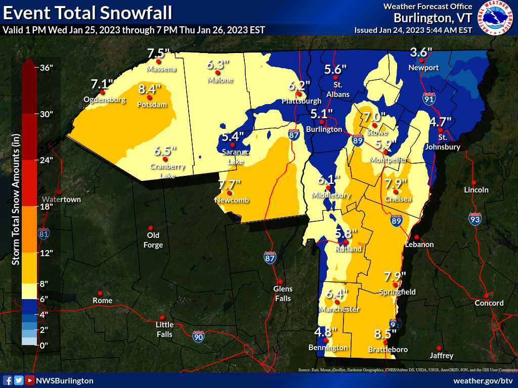
Next Big Thump Of Snow In Vermont Later Wednesday

The last snow forecast map from the National
Weather Service in South Burlington. Most of this
would come Wednesday night. A decent dump for most.
While southern Vermont finishes cleaning up from Monday's snowstorm, meteorologists are busily monitoring the next dump of snow on the Green Mountain State. That dump should come mostly later Wednesday afternoon and Wednesday night. 

This won't be an extreme snowstorm, but for much of the state, it will be another healthy, needed addition to the snow pack.

I noticed many places in Vermont now have a snow cover over 10 inches. That's nothing wild for late January, but it is a little better than what we were doing. 

There's actually snow in the air today from a much weaker system.  Accumulations will be less than an inch for most of us, but the mountains could pick up a couple to a few inches. Forecasters have backed off on the risk of snow squalls this afternoon, but that risk still looms to some extent. So watch out on the roads. 

By the way, one weird Vermont weather factoid I just have to mention. This time of year, the temperatures at Burlington has a daily range of 16 degrees, from a normal low of 12 to an average high of 28. Over the course of two days, Sunday and Monday, the temperature only ranged three degrees, from 28 to 31. Such a narrow range over two consecutive days is extremely rare.  

THE STORM ITSELF

The storm that will affect Vermont was organizing in southern Texas this morning. However, I'll focus on Vermont in this post, and get into the dangers other parts for the United States are facing from this dynamic storm in another post later this morning. 

It's worth bringing up, as for some people this storm is a bit of a doozy.

For us, as is typical with these storms, a push of warmth and moisture will pour toward Vermont Wednesday night and be forced to go up and over some somewhat colder air near the surface. That'll unleash a burst of pretty heavy snow for most of us Wednesday night. 

As always, some places will do better than others. This storm, as mentioned, has some power with it, which means by the time it gets here, it'll have some strong east winds, if not at the surface, then a few thousand feet aloft. 

This arrangement focuses the heaviest snow in southern Vermont, away from Bennington, and the eastern slopes of the Green Mountains. Those areas will see at least six inches of snow, probably more. A few places could conceivably approach one foot. 

These are the some of the same areas that saw the heaviest snow Monday, so the cover on the ground should get pretty deep along the eastern slopes. 

The Green Mountains will block some of the moisture from the Champlain Valley. The White Mountains of New Hampshire will do the same to the Northeast Kingdom. In those places, accumulations will be closer to five inches, or so the current forecasts indicate.

All this is why there's a winter storm watch Wednesday night for southern and much of eastern Vermont, but no advisories yet for the Northeast Kingdom and Champlain Valley. 

The warm blast of air overhead will probably be enough to let a bit of freezing rain enter the picture in southeastern Vermont. Some of the warmer valleys in the southeast might go above freezing for a few hours, too, which would cut down accumulations a bit in places like Brattleboro and Guilford and places like that. 

The storm will begin to depart Thursday, colder air will be drawn in to change any mix or rain to snow, and that snow will taper off. The western slopes might recoup some of the snow they will have missed out on earlier in the storm as northwest winds will favor continued snow showers there. 

We start getting into that long awaited colder pattern after this storm, so anything on the ground should stick around for awhile. Other, weaker little things coming through will give us bits of light snow occasionally into next week. Just to keep the snow cover fresh and clean and white for all of you. 

Wednesday, December 21, 2022

Early Thursday Update: Worrisome Wind Forecasts For Much Of Vermont

Updated wind forecast issued Wednesday afternoon. Peak
gusts for Burlington and St. Albans might be under-done
a bit. But note the 74 mph expected gusts in Rutland. 
UPDATE: 8:30 AM

I'm able to update this post, which I first wrote at 2 p.m. today.  In my travels, I'm waiting for a connection to Baltimore from JFK. 

Not much updating needs to be done to the previous discussion, below.  

The wind threat remains very, very real.  To the point where I see storm chasers appear to be on their way to Vermont to see the show Friday. 

Anytime storm chasers take an interest in your state, you know you have trouble.

One added piece of danger. It looks like some of the higher elevations could have two to six inches of wet snow tonight before the changeover to rain.

Some of that wet snow could still be clinging to trees when the howling winds arrive later Thursday night. That would only compound the inevitable power outage issues. 

The only other additions I'd make for now to what I wrote below is the powerful cold front that will sweep through Vermont will have its own batch of interesting weather. As if there wasn't enough of that already.

We already know temperatures will crash with the passage of the front, yielding to that vaunted flash freeze.  According to the National Weather Service, the front could be so dynamic that we could have thunder, torrential rain, heavy sleet and possibly a quick burst of snow toward the end.

Previous discussion follows, which is worth the read, as it's got some important info:

PREVIOUS DISCUSSION

Unfortunately, if current forecasts are true, the upcoming storm might be among the worst wind storms Vermont has seen in decades. 

According to forecasts issued last night and early this morning, the biggest worry spot is the Champlain Valley. 

Meteorologists have known for days that downslope winds on the western slopes of the Green Mountains would become ferocious on Friday morning. In favored spots right near the mountains, winds could gust to 70 or 80 mph or more.

That's bad, and would cause some damage, but it's happened before. This region is fairly sparsely populated, and the people who do live in this region have some experience with such powerful gusts. However, it's looking like the damaging winds might well  extend much further west into the Champlain Valley. 

Here's an excerpt from the forecast discussion from National Weather Service office in South Burlington, issued late Wednesday afternoon:

"Peak gusts comparable to a category 1 hurricane are forecast in the western slopes of the Green Mountains. We're increasingly concerned by the likelihood of populated areas well away from the mountains, including the populated Champlain Valley towns in Chittenden and Addison  counties, not accustomed to seeing winds of this magnitude."

This translates to winds gusting to more than 65 mph in these populated areas. It's not out of the question winds in the Route 7 corridor could reach 75 mph.  For comparison's sake the strongest wind gust ever measured in Burlington since at least 1900 was 72 mph. 

This could well be one of the worst wind storms in history, at least in the western half of Vermont. "Multiple long time forecasters have not seen winds at this pressure level at this magnitude in our region," the Wednesday evening forecast discussion stated, ominously."

The winds are forecast to ramp up quickly late Thursday night and early Friday and peak during the early to mid afternoon. 

According to the high wind warning that's been issued: "People should avoid being outside in forested areas and around trees and branches. If possible, remain in the lower levels of your home during the windstorm, and avoid windows."

What worries me the most is those many neighborhoods in the Champlain Valley that have lots and lots of trees. Some of those trees seem like they might crash onto or through some of those houses. This is dangerous!

I'd also expect some long lasting power outages in the worst hit areas.

Green Mountain Power announced Wednesday that they were able to keep a lot of the crews that came from out of state to deal with last weekend's massive snowy power outages here in Vermont to deal with this new storm. 

Despite the big crews ready to help with outages, GMP urged customers to be prepared for real trouble:

"With cold temperatures forecasted, customers should have a plan for where to go if they need to leave their home and how they would get there. With extreme high winds, there can also be hazards like flying debris that can make it unsafe for anyone outside, including crews." 

It's a tricky forecast, so it's still possible the wind could under-perform in western Vermont. But definitely don't count on that! The wind doesn't look like it will be as bad in eastern Vermont, but some tree damage and power outages seem likely even there.

The wind is obviously the biggest danger from this storm, but we continue to watch other issues:

 INITIAL ICE

Forecasts have trended a little colder with the onset of the storm. That means some places might receive a couple inches of snow, and some other areas will see some sleet and freezing rain. This will be a problem for anybody on the roads overnight Thursday. Rapid warming early Friday morning will erase this hazard.

FLOODING

This is still a real issue. The storm's powerful cold front will produce a period of heavy rain. Right ahead or along the cold front, a narrow band of torrential rain, similar to a summer squall line, seems possible.

Total rainfall looks like it will be in the one to two inch range, with higher amounts in some spots Combine that with rapidly melting snow, and you have a real problem.  A flood watch is up for much of Vermont, especially central sections of the state. 

River forecasts have gotten more detailed with updates. The Mad River at Moretown is expected to come close to moderate flood stage. Many if not most other rivers in Vermont will probably reach minor flood stage.

I'm especially worried about some of the smaller rivers in southern Vermont. The heaviest rain is expected to fall there, and the deepest snow from last weekend also accumulated there.

FLASH FREEZE 

The anticipated flash freeze is still on. With the cold front, temperatures will crash from the low 50s to the 20s in a matter of as little as two hours.

The freeze looks like it wants to come just a bit earlier than first forecast - probably late afternoon.

Roads will freeze instantaneously.  We also expect a brief period of freezing rain, sleet and snow as the temperatures plunge. 

BOTTOM LINE

If forecasts hold, this could be an historic storm for Vermont, comparable to the Great Appalachian Storm of 1950.  Hang onto your hats!