Showing posts with label snow showers. Show all posts

Tuesday, April 7, 2026

Snowy April Day Underway In Vermont, Should Clear Out Late, Spring Still Coming

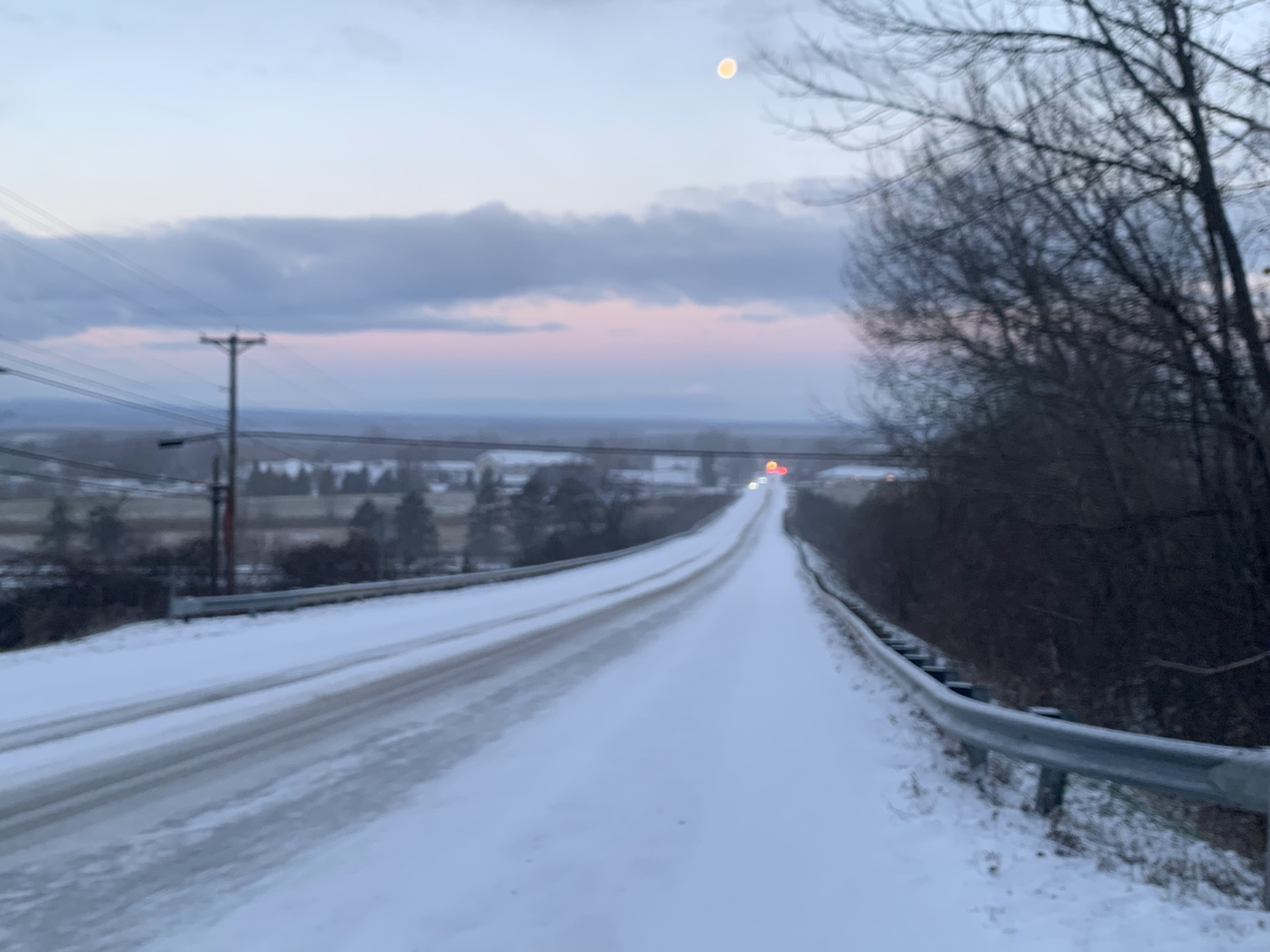
Traffic camera shows a snowy Route 9 in Searsburg, Vermont
around 7:30 this morning. An initial burst of snow hit
far southern Vermont. Much of the rest of the state
could see briefly heavy snow showers today. 
 If it hasn't snowed where you are yet as you read this in and around Vermont, it will soon. 

A small disturbance is blowing through, consisting oa a reinforcing shot of cold air that'll keep us quite chilly through tomorrow morning. 

A burst of pretty heavy snow has already crossed Bennington and Windham counties in southern Vermont, depositing a quick inch of snow. 

It left roads looking pretty slippery around Bennington and along Route 9 heading up and over the far southern Green Mountains. 

Scattered snow showers were across parts of central Vermont as of 8 a.m. Another main band of snow appeared to be twisting around the mini-storm's center not far from Watertown, New York. It was gradually heading east.

I'm not sure whether that band will hold together completely, but almost all of the state has a shot of a quick inch of snow, if it hasn't already happened. There's a slight question as to whether the snow band will be able to pivot into the far northern Champlain Valley, but for now, we should assume it will. 

In any event, the snow could briefly come down pretty hard anywhere in the state. That means that we'll have to harken back to our winter driving habits a bit as the roads will get briefly slick. Since this is happening in April during the day, some of the snow will tend to start melting off shortly after any bursts of heavier snow ends. 

Hopefully that means any problems with icy roads won't last long. This isn't a full blown winter storm, after all. Just a nippy springtime hassle. 

Yep, another snowfall forecast map. Perhaps the last one
of the season? Don't count on it. This map shows many
of us could get a quick inch of snow. There might
be locally heavier surprises in the mountains

Some places might have more than one burst of heavy snow.  Certain spots in the state could technically get up to two or three inches of snow. 

But it would be an inch that melts, followed by another inch that melts again. So nobody except the high elevations should have much  more than an inch of snow on the ground out of this. 

That said, small mini-storms like this in April can work with amazingly lame amounts of atmospheric moisture and create a good local dump of snow, so keep an eye on it through the day.

 A few isolated spots - mostly up high -  could end up with several inches of surprise snow. No guarantees, but just a possibility there. 

Our little disturbance should start to head on out late this afternoon, taking its snow showers with it. 

FRIGID TONIGHT

We're setting ourselves up for potentially the coldest April night since 2016.  What is likely, hopefully, the last Arctic high pressure system of the season should settle right over the top of overnight and early tomorrow. That means light winds and clear skies - the perfect recipe for a frigid night. 

Or almost perfect. If there's snow cover, it tends to get even colder in these situations. Many of us will still have some snow on the ground overnight, so that could make things even chillier.  The bottom line: Most of us will be in the frigid teens by the time dawn breaks tomorrow. A few of us could be in the single digits. 

That's damn cold for April. Maybe even close to record territory in a few places. Burlington's record low of 11 tomorrow is completely safe.  But it could get close in St. Johnsbury, where the record low is 10 above on Wednesday. The most likely candidate is Montpelier. Their record low tomorrow is 14 degrees, and the forecast low is also 14 degrees.

SPRING RETURNS

Don't worry, we still are convinced spring will come back in a hurry. And stay for awhile this time. Tomorrow afternoon will still be cool for this time of year, but 40s won't seem bad after today. 

Thursday and Friday will pop right up into the nice 50s to low 60s before another cold front comes in. But the next cold front is a spring front, not an Arctic one. So Saturday will probably only be about 50 degree, which is still reasonable.

On top of that, a stiff southwest wind could bring us up to near 70 degrees next Monday if thick clouds and rain hold off until the end of the day. Stay tuned on that one! 

Sunday, April 5, 2026

Sort Of A Stormy Easter Morning In Vermont, Gets Better Later

I know it's disappointing to wake up on Easter Morning to find it rather stormy out - rainy enough to soak and ruin your Easter bonnet and windy enough to blow it away. 
The first part of April is never pretty, and that was the 
case this Easter morning in St. Albans, Vermont. After
an expected throwback to winter, the progress of spring
will accelerate later next week 


But who the hell wears an Easter bonnet anymore? The Easter egg hunts might have to be postponed a bit, too, which might be a bummer.

But since this is all about ME!!!!!!, I personally like waking up on raw and wet Sunday morning in a cozy house. I can hear the wind blown rain clattering faintly on the metal roof, and the dull roar of winds still blowing through leafless trees, the gray skies, all starting the day quietly, contemplatory. 

We did - as expected - end up getting winds just as strong as the gusts we had Friday morning, but they came in the hours just after midnight, when we were less likely to notice them. The wind advisory that was in effect was justified.

Winds at the sandbar on Route 2 in Milton got to 59 mph. Jay saw gusts to 53 mph; Morrisville, 51 mph and Panton, 49 mph. There were plenty of gusts statewide in the 30s and 40s mph. Not enough to cause widespread problems but enough to rattle the shutters. 

Early this morning, roughly 2,800 homes and businesses had no power, mostly in the northern Green Mountains. 

REST OF TODAY/TOMORROW

The rain that moved in before dawn is now tending to suppress the wind somewhat. That rain should mostly move out by shortly after noon.  We'll end up with a third of an inch of new rain, give or take, so we're safe from any flooding. This afternoon will actually be OK, with temperatures hovering near 50, with breaks of sun and southwest breezes.

At least as measured in Burlington, there have only been two Aprils without so much as a snow flurry in Burlington (1941 and 2005).  This year won't join those two illustrious Aprils.

First of all, there's already been a snow flurry on April 1.  And more are probably on the way.  Progressively colder and colder air will start coming in this afternoon and night, setting the stage for some spring snow showers. 

Tomorrow will be chilly, but it won't be the worst of it. High should make it to the upper 30s northern highlands to upper 40s warmest southern valley floors.  There could be a few snow flurries in the mountains. 

THE COLD PEAKS

As the cold air continue to pour in Monday night and early Tuesday, more snow showers should blossom. For now, anyway, forecasts have measurable snow statewide by the end of the day Tuesday, though I have my doubts about this for warmer southern valleys. 

Tuesday will be a throwback to winter, with many of us receiving a dusting to an  inch of snow. Some  northern towns will probably never get above freezing on Tuesday afternoon. Tuesday night will get into the teens to low 20s. Spring will be on temporary hold.  Don't worry, happens every year. 

SPRING RETURNS

Strong high pressure, which initially will contribute to our nippy April weather, will warm us up as it passes nearly overhead and then off the east coast Wednesday.  By Wednesday afternoon, it'll get well into the 40s, which is still a little cooler than normal. But the strong April sun will make it feel much better.

After that, we get a huge break. April can be notoriously tempestuous, but the second half of next week and next weekend look anything but. High temperatures in the 50s and low 60s will get spring flowers and plants and tree buds going, and no notable storms are on the way. 

Sure, this Easter morning is gray and brown and muddy and ugly, as early April is in Vermont. But that promise of spring keeps getting more and  more real. 

Wednesday, March 11, 2026

Ice Jams, Flood Risk, Record Heat, Freezing Rain, Rain, Snow, Wind, Storms. Vermont March Weather Rolls On

Another view of an ice jam backing up water along the 
Missisquoi River in Enosburg Tuesday. The ice
jam closed Boston Post Road near Route 105.
Vermont is still  under a flood watch through
tomorrow
Mark Twain once said, "In the spring, I have counted 136 different kinds of weather inside of 24  hours."

He was referring to New England when he said it. I'd guess he might have been in Vermont in March when he came up with that gem. 

A day after we had a hottest for so early in the season warm spell in the Green Mountain State. temperatures this morning were in the low to mid 30s. 

As forecast, there were a couple drops of freezing rain in extreme northwest Vermont.  We weren't expecting much and there was even less freezing rain than the trifle we thought we'd get.

Before we move on, we should gaze back at the record highs, and how we are re-writing weather records in the age of climate change. March records have really shifted. Before 1990, Burlington had never reached 70 degrees earlier in the season than March 20.

Now with yesterday's 73 degrees - the warmest for so early in the season - it's been in the 70s eight times on or before March 20 since 1990. Six of those occasions have been since 2012.  

This isn't just a Vermont thing. Hundreds of record highs were set over the past few days in the central and eastern U.S. New York City reached 80 degrees, the earliest on record it's been that warm there.

Another record heat wave is set to begin next week in the western U.S. 

The switch to hot weather out West means we in Vermont will probably not be seeing more record high temperatures for awhile. 

A southward dip in the jet stream over eastern North America will keep colder weather and storminess in our neck of the woods for next couple of weeks. 

Let's get into the details:

TODAY

Eventually - later this morning or early this afternoon - the wind should swing back from a southerly direction, and that will pump temperatures back up in  to the 50s for most of us west of the Green Mountains. It'll probably stay in the mid and upper 40s east of the Greens. 

The good news is forecasters have cut back on the amount of rain we should expect between now and tomorrow morning. Don't celebrate too much, since we should still see enough rain, combined with snow melt and the last of the ice jams to keep us under a risk of flooding.  

The Otter Creek in Center Rutland is forecast to go into minor flood stage tomorrow. Other Vermont rivers are expected to get close to flood stage. And remember, these river level forecasts are iffy. Just a little extra rain, or a little extra snowmelt can make a big difference in how high the water gets.\

We should see some scattered showers, maybe even an isolated rumble of thunder here and there today. Much of the time should be dry, especially south and east. The rain should fill in to become more widespread later this afternoon and during the first half of tonight. 

THURSDAY

The sharp cold front will come in from the west mostly before dawn tomorrow, and that will send us back into winter. Temperatures will stay steady near the freezing point, or slowly fall during the day. Gusty winds will make it feel colder. At least the cold will shut off the snow melt and end the threat of flooding.

We could see some snow showers, but accumulations won't be anything to really worry about.

FRIDAY SATURDAY

A relatively small storm should come in from the west. We could get a couple inches of wet snow out of this later Friday into Saturday morning  By March, temperatures can be marginal between rain and snow. We'll want to take a closer look at this when we get closer. 

SUNDAY/MONDAY

A larger storm is looming for the end of the weekend and start of next week.  This far ahead, it's hard to tell exactly what that means for us. For now, meteorologists are going with a period of snow and mixed precipitation Sunday, followed by a brief squirt of warm, windy, showery weather Monday, followed cold north winds and some snow Monday night and Tuesday. 

Since that storm is several days away, don't be surprised if the forecast for how it plays out changes big time. 

The cold wave next week looks pretty sharp and intense, even if it does't last all that long.  But we are possibly looking at a couple days with highs in the 20s and lows in the single numbers. Our false spring will definitely be over by then! 

After that cold wave, as usual, the weather forecast gets  really uncertain. But that's OK, we have more than enough on our plate for now. 


Monday, February 16, 2026

Still Not Much Clarity On Vermont Weather Forecast But Some New Clues Emerging

A big icicle formed on my shed yesterday as the
warming sun of mid-February increasingly fights
against the cold. Today will actually feel rather
springlike but winter isn't done with us yet. 
 If you have plans for this coming Wednesday and Wednesday night in Vermont, we can't help you much with any weather forecasts Those annoying computer weather forecasting models are still arguing amongst themselves. 

Which is odd, since Wednesday is only two days away. More on that in a minute, but if you are more of in the moment type, we've got you covered.

TODAY/TOMORROW

For starters, today will be the most springlike day we've had yet.  Temperatures should get well into the 30s across most valleys, and we should have a fair amount of sun, which feels warmer and stronger now that we're nearly two months past the winter solstice. Winds will be on the light side too,

I get it. A day with a high of 37 degrees isn't exactly full-blown spring. But it's a start after the frigid weather we've had over the past month. 

Any hints of spring are fleeting this time of year, too, and so it goes this time. Yet another weak disturbance should come through later tonight and early tomorrow. As has so often been the case this winter, the system is no big deal, but might have atrocious timing. 

The problem is some light snow showers might switch over to light, patchy freezing drizzle just in time for the Tuesday morning commute. In the case of any kind of freezing rain, it takes only a tiny bit to send your car flying off the road and into a ditch if you're not careful enough.

The tricky thing is this will be patchy and temperatures will be just below freezing. So you'll be cruising along on just wet pavement, then all of a sudden it's ice and the cars and trucks on the Interstate are suddenly doing a literally smashing dance with each other. 

So, slow it down just in case Tuesday morning. 

WEDNESDAY QUESTIONS

We're to the point now in which we can say there will probably be some sort of precipitation in at least part of Vermont Wednesday and Wednesday night.   

Tbat's not very helpful, but that's all we've got for now. 

A storm in the Midwest will be heading in our direction but it will be shearing out on its way east. That means the storm will be pulled and stretched and weakened. And therein lies the forecast questions. 

By the time it gets to New England, it will be a fairly narrow band of snow or mixed precipitation. Colder high pressure from Quebec will on Wednesday try to nose down into New England, while to the south, moisture from the Gulf of Mexico will tried to feed into our weakening storm.

So, will the cold air win out and we get nothing? Or will the warm air win and we end up with a mix? Or, choice #3 favored by our winter sports industry, does this thing just drop a swath of snow right across Vermont.

For now, the best guess is far northern Vermont gets little or no snow, and perhaps far southern Vermont sees a mix with snow in the middle. Whatever happens, this doesn't look like it will be a blockbuster storm. 

But don't hang onto that gift to the ski gods scenario.  We should have a more clear view on this tomorrow. Or at least we'd better, as time is running out. 

After Wednesday, the weather pattern looks really active, so there will be several other chances for snow or a mix between now and early March.  I'm not even going to try and tease those out yet. 

Saturday, March 8, 2025

Snow (Temporarily) Rebuilding In Vermont Mountains; Flurried To Death Elsewhere

After a sunny day, traffic cams show a snow squall
hitting Interstate 89 in Williston shortly before 6 p.m.
It was brief, but left areas of black ice behind. 
Same situation could well happen in parts of
Vermont today. 
Vermont weather on Friday was certainly windy, with a wait a minute it will change character.  

So stereotypical of March, so there you go. Winds gusted as high as 63 mph at a  fairly  high elevation in Jay. Elsewhere, we had reports of 53 mph in Lowell, 51 mph on Colchester Reef and in Springfield and 49 mph in Alburgh and West Rutland. 

Almost everybody saw top winds in the 40 mph range. The gusts were enough to produce some power outages. The number of homes and businesses without power Friday peaked at around 2,400 shortly before 2 p.m. Friday. 

Also true to March character was the weather. It was bright and sunny in much of Vermont for a good chunk of midday. Then, as expected, those briefly sorta heavy, gusty hit and miss snow showers rolled in. 

I noticed Burlington got a quick. 0.7 inches of accumulation in a brief burst of snow late Friday afternoon. Traffic web cams showed highways in parts of Chittenden County getting iffy. There were quite a few reports of black ice, and a few slide offs and car  mishaps.   

NEXT UP

More of the same this weekend as a spray of small disturbances blow through from the west and northwest.

Snow prediction map from the National Weather Service
office in South Burlington through Monday morning.
Most of us won't get much, but some areas of the
northern Green Mountains, New York's Adirondacks
and New Hampshire's White Mountains could get
 a  decent six inches of snow out of this. 
None of these disturbances will be capable of bringing much snow. But it will add up in the central and northern Green Mountains, where a fresh four to seven inches should be on the ground in those high elevations by Monday morning. 

One of these little weather disturbances was putting down some snow showers mostly across  central Vermont early this morning. 

As of 6 a.m., it was snowing again a little in Burlington, though skies were clear overhead here in St. Albans. The hit and miss character of these snow showers continues. 

Judging from the traffic cameras, you might well encounter areas of snow covered roads and black ice this morning.  I'd take a little extra time getting to where  you are going early today because of this. 

Looks like new snow overnight ranges from less than an inch in the valleys to at least a couple inches in some of the mountains. 

Another hiccup in the wind flow overhead will bring central and northern Vermont another smattering of gusty snow showers this afternoon and evening. 

Much like Friday's snow showers, these will be hit and miss, and a few of them might contain very briefly heavy snow and gusty winds. Just enough to make it a little dicey on the road if you drive into one.

Today will stay windy, though not as bad as Friday. But it will be colder, with most places staying at or below freezing all day. 

After maybe a little sun Sunday morning, the next little weather thingy comes in from the west and northwest.  This will have a slightly better, more organized packet of snow showers with it.  Still, it will be light stuff. Most of us will see yet another dusting to two inches, with a little more in the mountains. 

SPRING, WITH INTERRUPTIONS

It'll start to warm up on Monday, and Tuesday should give us a brief treat of springtime temperatures. Many of us will see some sun and highs up in the low 50s.  Very nice!

Yesterday, I thought there'd be a little cold air oozing into northern Vermont Wednesday and maybe missing the south. 

Now it looks like that cold front from Quebec will blast on southward through the state, giving us a brief return to chilly conditions Wednesday. 

Then, it looks like a large storm will blossom somewhere in the central Plains next weekend. As it stands now, it looks like that storm will pump the warmest air of the spring so far into our region.  Early hint suggest it's even possible the warmer towns could reach 60 degrees in a little over a week.

Will be interesting to see if that comes to pass. As usual, spring will be coming to Vermont in reluctant fits and starts. 

Friday, March 7, 2025

Hints Of Springtime In Vermont That Feel Wintry Happening, And Coming Up

River gauge readings from yesterday on the Mad River
in Moretown, Vermont. Click on the image to make
it bigger and easier to read. You can see an
abrupt rise in the river as water backed up behind
an ice jam. Then the river level dropped back down
suddenly when the ice jam broke up.
 No big storms are on Vermont's immediate horizon, but some subtle and potentially frustrating little weather events coming up are sort of signs of spring.  

Even though those signs of spring are paradoxically wintry.

ICE JAMS

The first of course is ice jams, something we had to keep an eye on during Thursday. 

Thawing weather and rain basically created piles of ice. 

There was a lot of ice movement on the rivers, and some of that ice got jumbled up into piles and clogs near obstructions. There were only perhaps a couple real ice jams in Vermont that I'm aware of. They caused at worst minor flooding and minor damage.

The jams didn't form in the "wrong" places - i.e. just downstream from a riverside town or city.  So in this case we didn't have to deal with a lot of buildings getting flooded, 

The most notable jam was - as mentioned yesterday - on the Mad River near Moretown. You can see on the chart in this post how the jam abruptly made the river rise to flood stage. Then the jam apparently broke and the water level almost instantly returned to normal levels.

With colder air in place, if there are any ice jams, they're probably pretty stable for now. They could always abruptly move, but the chances of new problems with these over the next few days is pretty low.

CONVECTIVE SNOW?

Convective clouds and updrafts gather themselves into
rain and snow showers last March 17 in St. Albans,
Vermont.  This time of year, the sun begins to get
strong enough to help power scattered hit and 
miss snow showers even on cold, blustery days.
In the warmer seasons, strong sunshine can cause updrafts.  Under the right conditions those updrafts can help form showers and thunderstorms. That's why we do have those hit and miss storms all summer around here. Those scattered showers and storms are known as convection. 

Now, today by any measure will be a chilly and blustery one, nothing summery about it.  Temperatures will barely get to freezing if that. It's so gusty that a wind advisory is up for most of Vermont outside the Champlain Valley. In the advisory area, gusts to 50 mph could cause some isolated power outages.

Helping with the gusts is the strengthening March sun. It's getting powerful enough to heat the ground to an extent, creating updrafts and instability that can bring higher gusts to the surface. The fields and forest floors are still snow-covered, so the effect isn't nearly as pronounced as it would be with bare ground, but the sun can have an effect. 

The air is a bit unstable to begin with, so a few snow showers are inevitable anyway. That sunshine peaking through the clouds today might help power up some scattered hit and miss snow showers, much like those summer thunder showers.  Since this is convective, a few might be very briefly heavy with stronger, gustier winds. 

Most of us won't see something like this today, but a few places probably will. So yes, a harbinger of spring will probably generate a few minutes-long little mini-blizzards here and there. Luckily, there will be no big snow accumulations out of any of this. 

You're probably going to see more of this type of situation on blustery days during the rest of March and probably a good chunk of April.

BATTLEGROUND

A frustrating aspect of spring - especially in March and April in Vermont - is those pesky stalled fronts in which it seems everybody in the central and eastern U.S. is enjoying spring weather except northern New England. 

The battle line this time of year between the forces of spring and the waning strength of winter is right along the Canadian border.  For the most part, that battle line is further north than, say, January. 

The result this time of year is that as most places warm up, often  a shallow, dense layer of chilly air oozes down from Quebec, making parts of Vermont shiver while places not that far south enjoy balmy, sunny spring breezes.

This set up seems to most often affect the northern Champlain Valley. They cold air hugs the surface and often extends upward only a few thousand feet. 

There's no mountains to block this shallow cold air between Quebec and northwest Vermont, so the chilly air floods in.  You end up with days in which say, Bennington, might be sunny and 60 degrees and St. Albans is stuck in the mid-30s. 

This set up looks like it might happen toward Wednesday. Initially, some warm air would bathe pretty much all of Vermont. Forecasts call for highs in the low 50s Tuesday, which would make it the warmest day so far this year. 

Then that pesky shallow cold air from Quebec seems to want to make an appearance. Currently, forecast highs in the northern Champlain Valley are around the low 40s Wednesday, but I think it might even be colder than that. This situation would probably linger into at least Thursday. 

These things are a little hard to predict and tease out days in advance, so things might still work out differently midweek. We shall see. 

Even so, that low level cold air is another paradoxal sign of spring.  Northern Vermont is in the war to reach spring. Chances are we'll lose the battle Wednesday, but we'll win the overall war eventually. 


Sunday, March 17, 2024

Vermont's Last Winter Week? This MIGHT Be It

A springlike sunset with grass starting to turn green
this past Friday in St. Albans, Vermont. With astronomical
spring arriving this week, we will take a multi-day
plunge into wintry weather. 
 Astronomical spring starts at 11:06 p.m. this Tuesday, March 19.

After a springlike winter, the arrival of the new season will plunge us Vermonters back down into winter.   

Don't worry, it won't be terribly painful.

A change in the weather pattern is going to put at least a temporary stop to an incredibly warm March. Up until now, it's been on pace to become one of the top three warmest Marches on record.

After this week, maybe not.

The first of a series of cold fronts is coming through in scattershot fashion today. It will still be on the mild side, with temperatures well into the 40s, maybe flirting with 50.

Monday will be seasonable with scattered rain and snow showers. It'll get up to near 40. So meh weather to start the week. Then winter hits.

REST OF WEEK

Tuesday looks chilly, then a reinforcing cold front comes blasting through Wednesday with a batch of snow showers. Accumulations won't amount to much in the valleys. But between tonight and Thursday the mountains could pick up a few inches. A little late season catch up snow for them, I guess.

Then, on Thursday and Friday, it will be downright cold for this time of year. On both days, high temperatures won't get above freezing for many of us. That'll be the first time that's happened since late February. Lows will be well down in the teens. 

I don't think the cold will destroy too many of the early season plants that have prematurely started to come up in Vermont gardens.  Magnolia buds might be nipped and blooms on some crocuses might not survive.

But the green shoots of crocuses, daffodils and other plants that have emerged are still young enough to skate through the cold weather just fine. 

The air this week will be nippy, but nothing all that odd for March. We've just gotten used to the strange balminess of February and March this year. 

LAST WINTER WEEK?

Even though we had a winter that wasn't, many of us still want to emerge into full-blown spring.  The chill might last into next weekend but there are hopeful signs that it could start to warm up again after that. 

This could well be the last week of the season that feels like winter, but don't count on it. 

Historically, we've endured some pretty wintry weather in late March and April. Not to depress you, but here are some examples:

In 1923, the final week of the month featured three mornings that were below 0 in Burlington, including minus 8 on the 29th. That's the latest subzero reading on record.

On April 7, 1972, Burlington endured a high of 24 degrees and a low of 2 above. That's colder than average for mid-January.

And in April, 1975, measurable snow fell on each of the six consecutive days from April 3-8. Between April 4 and 9 that year, only one afternoon made it above freezing and then only to 33 degrees. And the first overnight thaw of April, 1975 didn't hit until the 19th. 

So yeah, if you complain about this upcoming week, you haven't seen the worst that a Vermont spring could bring. 

Wednesday, December 13, 2023

Not Done With The Snow Showers Just Yet. Questions About A Future Storm?

A snowy, bright scene during a brief interval of blue skies
and sunshine Tuesday.  Despite snow showers this morning
and chilly temperatures through tomorrow, an overall
warm pattern means we might not actually have
a white Christmas this year. 
 As expected, snow showers buzzed through parts of Vermont last night, laying down at most an inch of snow, with most places just getting a dusting. 

Roads got a little slick, again, as expected, so there were some iffy patches.

If you're heading to work this morning, you might run into a little more of that. Roads aren't all that bad, really, this Wednesday morning, but we're not done with the snow showers.

Patchy snow showers, some of them moderately heavy, were moving toward northwestern Vermont as of 7:45 a.m. this morning. They could reduce visibility and quickly turn roads icy this morning. 

(By 8 a.m. it was looking pretty ominous, snow wise, just to the west of my perch in St. Albans, Vermont).

The snow showers might continue to early afternoon before tapering off.  Accumulations will be an inch or less, except possibly a little more in the mountains. Especially the Adirondacks and maybe far northern Green Mountains. 

These snow patches and bursts are associated with a series of what are essentially little cold fronts coming through. It's mild this morning, with temperatures near the freezing mark.  Instead of rising, temperatures will hold steady or slowly fall through the day. Northwest winds will add to the chill.

Again, no big deal for December, but the snow showers, the visibility issues and the icy patches on the roads are all worth taking into consideration. 

Aside from seasonal temperatures today and tomorrow, the overall pattern for us and pretty much the entire Lower 48 is mild conditions. Possibly lasting through Christmas. 

That makes the prospect of a white Christmas iffy in many Vermont locations, despite snow on the ground in many spots now. 

Forecasters are looking at a weird, strong storm that will come out of the Gulf of Mexico and hit Florida and maybe other areas of the Southeast with heavy rain, high winds and severe thunderstorms by Saturday. There's a chance it could move up the coast and give us some bad weather early next week.

Early bets are that it might mostly miss us here in Vermont. Some computer models hit us with heavy rain and possibly snow, but many other runs of the models take the storm a little too far east to bother us too much. 

There's a lot of  time for changes to the forecast.  Once we get toward the weekend, we'll start paying more attention to that system to see if it will affect us. Until then, expect some relatively mellow Vermont weather with near and above normal temperatures. 

Tuesday, December 12, 2023

Heads Up: Gusty, Heavy Snow Showers Possible In Vermont This Evening; Few Issues Wednesday, Too

The sun came out to reveal something of a winter 
wonderland in St. Albans, Vermont today, but an 
approaching band of snow showers could interfere
with motorists on the roads later this evening. 
 A word of caution if you're going to be out on the Vermont roads this evening.

There's a good chance some gusty, rather heavy snow showers will pass through. They could be intense enough to almost (but not quite) qualify as snow squalls. They'll sharply reducing visibility and make in roads instantly slick.  

Accumulating snow won't really be the problem.  The snow showers won't last especially long in any one place. Expect an inch or less of new snow with this harassing band of bad weather. 

The National Weather Service in South Burlington this afternoon said the timing of this band of snow showers is such that it will be crossing northern New York at around 5 p.m; entering northwestern Vermont roughly around of 7 p.m. and be very approximately on a Newport to Middlebury line by 9 p.m. 

Judging from radar trends, those snow showers might arrive a little bit earlier than the time line I've just outline. Skies at sunset here in St. Albans took on a vaguely threatening mood. 

It was a little above freezing today across almost all of Vermont. The expected snow showers will also drop temperatures, so water on roads will probably freeze as these snow showers move through. 

So, you'll want to be a little careful as you drive around tonight. 

After the possibly heavier snow showers pass through,  snow showers will probably continue off and on through the night and into Wednesday morning. Most of us in northern and central Vermont will at least see some snowflakes in the air well into the day tomorrow. A few lucky devils will once again see some briefly moderately heavy snow showers.

Those might affect both visibility and the conditions of roads as you drive to work Wednesday morning. 

Once again, accumulations will be modest. Less than an inch for almost everybody. Total snowfall up at the ski areas and summits in central and northern Vermont could go to two or three inches between now and Wednesday afternoon.

Not a big deal, but it's a bit of frosting for winter sports enthusiasts. 

This spell of snow showers isn't anything unusual for a Vermont December, but it's still worth paying a little bit of attention to if you're driving anywhere tonight or tomorrow.

Tuesday, November 28, 2023

Winter Still Toying With Vermont, Bits And Pieces Of Travel Trouble

A heavy early morning snow shower iced up the road
in front of my St. Albans, Vermont house, but
shortly after, blue sky and the moon appeared. This
kind of changeable early winter weather
should last all day. 
 I awoke to another surprise heavy snow this morning in St. Albans, Vermont. 

In this case, it was just a pretty hefty snow shower that passed by quickly, leaving partly cloudy skies and a dawn view of the moon in its wake. 

But the snow showers definitely left behind a half inch ofd new snow and some very slick roads, making conditions pretty hazardous for some on their morning commute. 

You'll want to take some extra time getting to work this morning especially if it snowed where you are. 

The snow showers were hit and miss. Some areas were still fine, others a mess between 7 and 8 this morning. That state of affairs should last all day. 

A weather disturbance and cold front is instigating the snow showers.  They could hit anywhere anytime today, but the best chance is this afternoon and in central and northern Vermont, and the entire Green Mountain range. 

Some of the snow showers, like the ones in St. Albans early today, will be on the heavy side. But they're racing along and should be pretty brief.  Which means total accumulations will be an inch or less. The exception to this will be an area along and north of Route 2 from east of Burlington into New Hampshire, which could pick up one to three inches. 

The Connecticut Valley of southeastern Vermont should see pretty much nothing at all. Meanwhile, the Green Mountains, especially from Killington north, should see two to as much as six inches out of this. 

All this will make things unpredictable on the roads all day. Things will be fine one minute then they won't. Or, you'll be blissfully traveling along a snow-free road, only to encounter the next minute some low visibility snow, and ice under your tires. 

This state of affairs should last through today's evening commute, so beware. 

The rest of the week looks fairly quiet, but there are signs of some modest storminess Friday and perhaps something a little more substantial early next week. But the weather pattern is especially hard to predict right now, so any forecast beyond a couple days is suspect. 

Just wait it out and check forecasts as they're updated. 

Monday, November 27, 2023

Vermont Recovering From Surprise Snowstorm; More Minor Winter Weather Still Coming

Breaks of blue sky appeared in the sky over St. Albans,
Vermont after last night's wet snow and rain, but the
darker clouds hinted at a few more snow showers in our future.
Vermont is still recovering from the surprise, rather poorly forecast snowstorm from last night.  

Temperatures were above freezing statewide this afternoon, so that the slush on plowed roads melted away. 

More snow accumulation reports came in during the day, and those totals were pretty impressive for a storm that was forecast to produce just a trace to four inches of snow. 

The highest snow totals I found were at pretty high elevations - near 1,500 feet above sea level. A spot in Northfield, elevation 1,400 feet, reported 12.5 inches. Another spot in Hyde Park, elevation 1,600 feet, had 12 inches. Other reports included 11 inches in Albany and 10 inches in Sheffield, both in the Northeast Kingdom. 

Elevation made a huge difference. Valleys in central Vermont had closer to four to six inches. Here in the Champlain Valley, downtown St Albans had absolutely no snow this morning. My place, just 300 feet higher in elevations, had an inch.

Actual snow totals from last night's storm. Map from
National Weather Service/South Burlington. Lots of'
8-12 inch reports. 
An inch of snow normally melts quickly when temperatures reach 40 degrees. But the snow was so dense that much of it remained in my yard as darkness fell. 

Vermont electric utilities have been working all day, and will be working into the night to restore power to the thousands of people who lost power due to the heavy, wet snow. At the peaks this morning, nearly 34,000 homes and businesses had no electricity.

As of 5 p.m. today, that number was down to a little under 10,000.

More wintry weather is on the way, but it shouldn't be anything extreme. At least locally. f

An impressive band of lake effect snow, laced with lightning strikes, was slamming areas downwind of Lake Erie a little south of Buffalo, New York. An even more impressive snow band was just organizing late this afternoon off of Lake Ontario, which will dump at much as two feet of snow in the notoriously snowy Tug Hill Plateau. 

The remnants of those lake effect storms will drift into Vermont late tonight and especially tomorrow as snow showers. A weak disturbance coming through in the afternoon will probably make the Vermont snow showers a little more widespread. 

This was the forecast for last night's storm. It REALLY
overperformed. 
The bottom line is you'll still need to be a bit careful driving to and from work tomorrow. In the morning, water from today's snow melt will freeze on pavement, leading to some icy patches.

 In the afternoon and evening, snow showers will produce light accumulations in many spots. It doesn't take much to make roads slippery, so even a dusting or a half inch of snow could cause problems. 

Some summits and western slopes of the central and northern Green Mountains could receive two to four inches of additional snow tomorrow.  The ski areas are off to a pretty good start. 

EDITOR'S NOTE

I will be traveling overseas between tomorrow and December 9. I'll do a post tomorrow morning, but after that, posts might not appear consistently every day and might appear at odd times, or hours you're not used to. I appreciate your patience! 


Sunday, November 19, 2023

The Vermont Week Ahead: November Annoyances Continue

Norway maple leaves, some still green remarkably remain
on trees in Burlington, Vermont Saturday. Warm nights 
this autumn have kept the foliage on these trees much,
much later than normal. 
Although it's been a relatively chilly Vermont November so far, I'm still struck by the lack of nighttime cold.  

So far this season in Burlington, the coldest it's gotten is 29 degrees.  

The normal low this time of year is 31 degrees, so you'd think we would have had nights colder than the upper 20s by now. For perspective record lows this time of year are in the single digits above zero.

The result is, in more urban areas of Vermont anyway, a few leaves have stuck to some trees.  

Norway maples usually lose their leaves pretty much last of all the trees except larches and Bartlett pears.  But the Norway maple leaves have in the past always been gone by early November. 

Yesterday was November 18 and the leaves are still hanging on, at least around Burlington.  I've never seen anything close to this before. Another albeit minor sign of climate change, maybe?

In any event, this week should get rid of those leaves once and for all. A pretty good cold front today will eventually plunge temperatures into the teens to maybe near 20 by Tuesday morning, so that will bring us toward winter. 

The whole week is setting up to be fairly wintry, as we remain stuck in a cold weather pattern. I don't see any epic storms coming our way, but there will be trouble from time to time. 

Let's break it down day by day.

TODAY: 

I, and the National Weather Service office in South Burlington, noticed some buzz on social media last night of the possibility of snow squalls today, which can be dangerous. 

It ain't going to happen. Take the snow squalls off your schedule today and don't worry about it. It was just the usual social media clickbait and fake news. 

With a cold front coming through today and a generally unstable environment, there's a decent chance of seeing some snow showers around. But they won't be heavy, and might mix with rain in warmer valleys. 

The favored western slopes of the central and northern Green Mountains might see a couple inches out of this, but most of us will see a dusting at best. 

MONDAY:

A cold one to start getting rid of those pesky yellow Norway maple leaves clinging to the trees, preventing you from raking the lawn. If you're in central or northern Vermont, I doubt the temperature will get above freezing all day. For many of us, it will be the first such day of the winter season.  Aside from a few mountain flurries in the morning, we might actually see some sun in the afternoon. Yippee! 

Monday night will be cold for this time of year, as mentioned, with temperatures bottoming out in those teens. Maybe some single numbers in the coldest hollows.

TUESDAY:

Quiet and cold in advance of a messy storm. Increasing clouds, highs in the 30s

TUESDAY NIGHT AND WEDNESDAY

The mess of the week, just in time for Thanksgiving travel.  The forecast details will become clear in the next day or two. But for now, expect a messy mix of wintry crap coming out of the sky overnight Tuesday and likely into Wednesday morning.

Obviously, that means roads could be kind of nasty in the morning.  At this point, it's looking like it might go over to rain in most spots Wednesday afternoon. So if you can delay your trip until then, that might be a good idea.

THANKSGIVING:

Back to quiet and cold with snow showers around. Unless Wednesday's storm somehow gets hung up nearby, there shouldn't be enough so to cause travel trouble.

BLACK FRIDAY

Sorry, but Black Friday is a day I distain.  If you want to wait in a cold, blustery parking lot hours for dawn to grab those so called door buster deals, knock yourself out. Perhaps literally, the way some people behave on Black Friday. In any event, no storms seem likely on Friday. Just snow flurries to give you a bit of holiday cheer of sorts. 

Remember the further out the forecast, the more likely it will change. Expect the forecast for later in the week, especially Wednesday through Friday, to get some updates. 

Tuesday, October 31, 2023

It's Official: First Autumn Freeze Across Vermont; Record Late; Icy Roads Too

Fog and drizzle and chill made for an appropriate pre-
Halloween mood yesterday before last night's freeze arrived.
 Early this morning, it was below freezing everywhere in Vermont, except perhaps right along the shore of Lake Champlain. 

For most of us, that's the latest first autumn freeze on record.

It's complicated for the official National Weather Service readings in the Burlington area.  Weather measurements have been taken at the airport in South Burlington since 1941.  This is the latest freeze at the airport since at least then, and most likely well before that.

The old record for latest first freeze at the airport was October 28, 2022 - yes, just last year. 

Prior to 1941, weather measurements were taken closer to Lake Champlain, where it is warmer on clear, calm autumn nights. So the record latest freeze from those days was November 1, 1920.  It's unknown if the site where temperatures were taken way back when got below freezing this morning. 

The cold weather this morning prompted one of those dreaded special weather statements from the National Weather Service. Water from yesterday's rains probably froze on some of the roads, especially on bridges and overpasses.

As you're driving to work this morning remember that some areas of the harmless "wet road" is actually glare ice that can send you careening into other cars or off the road.  This includes main roads. I have reports of at least one crash on an Interstate 89 overpass in Richmond.  Other crashes closed stretches of Interstate 89 between Montpelier and Richmond. I'm sure other bridges on the Interstate are icy, too. 

My truck parked in St. Albans, Vermont looking 
very iced over this morning. 
By the way, yesterday's rain brought the month's total to 6.41 inches in Burlington, which makes it the third wettest October on record as well as one of the warmest.

I'll have much more complete climate data for October in a post tomorrow,

Meanwhile, the chill continues on.  Highs today and tomorrow will barely make it to 40 if we're lucky in most of northern Vermont. Southern valleys might be a tad warmer than that. More freezes are coming tonight and tomorrow night, with lows for most places in the 20s.

For the little monsters trick or treating this evening, they can expect temperatures in the 30s, but at least it will be dry, with no rain or snow. 

Another disturbance will probably give us some snow showers Wednesday, mixed with rain in the valleys. Don't worry, any accumulations will be really light to non-existent. 

It still looks like it will turn a little warmer toward the end of the week, but not spectacularly so. For a change, there's no sign of yet another big warmup coming.

Sunday, March 19, 2023

Vermont Weather Week Ahead: Not As Wild As Last Week, But Still "Interesting"

After a brief snow squall, a cold wintry sun tries to fight
its way through the clouds in St. Albans Sunday morning.
Warmer weather is on the way, though. 
 As is customary, I like to start Sunday with a look ahead, at least as best we can, at the Vermont weather week ahead.  

For those of you adverse to winter, a couple pieces of good news: For one, unlike last week,  nobody in Vermont will get 40 inches of snow this week. In fact, only a little snow will fall, and many of us will see a dusting at most.

The big snow winners will be in the central and northern Green Mountains, where the remnants of lake effect snows from New York could pile of several inches of fluffy snow.  That's a far cry from fell last week, though! 

The second piece of good news for those anxious for spring is that today has a very good shot at being the coldest day until next winter. 

Normal highs in Vermont valleys are now in the low 40s, and rising day by day as we head into spring. It's gradually getting harder and harder to stay below freezing all day. 

Today, though, we'll stay at January-like levels, with temperatures for many of us not getting out of the mid-20s. Gusty northwest winds bring wind chills into the single numbers and teens. You'll see spots of sun, but also snow showers, especially north of Route 4 and in the mountains all the way down to and past the Massachusetts border.

A few snow showers might be briefly heavy, so you'll want to watch for sudden problems with low visibility and slick pavement on the highways here and there today. As drier air moves in this afternoon and evening, the snow showers should lighten up somewhat. 

After a rather cold night tonight, things get better.  

Most valleys, except for some of them north of Route 2 on Tuesday, will to 40 or above each day Monday through the end of the week. (Northern valleys might have to settle for highs in the 35-39 degree range on Tuesday).

The weather should be fairly quiet, and great for sugaring in the first half of the week. 

The second half gets questionable. Storminess seems to want to come in, or at least some precipitation. 

Although Vermont big snowstorms are possible into mid-April, it is getting harder and harder to snow as we get into the second half of March. It's just getting too warm. 

It's looking like whatever comes in the second half of the week will be mostly rain.  The computer models disagree on how much rain and the timing of it. 

If it's just light rain, the snow will just continue to melt in an orderly fashion and there would be nothing to worry about. If it's a heavier rain, we'll need to watch for some flooding from that rain and melting snow. 


Thursday, February 23, 2023

Before The Storm: Volatility Showed In Vermont Weather (Video)

A somewhat volatile looking sky over St. Albans, Vermont
Tuesday afternoon ahead of a gusty, squally cold front. 
 Ahead of the winter storm that rolled through Vermont on Thursday, a couple smaller disturbance sort of hinted at the building volatility in the weather.  

A weak cold front came through on Monday, but it had enough oomph to spread snow squalls up near the Canadian border. 

Here in St. Albans, we had no squalls on Monday, but some gusts of winds and some really fast moving clouds. Reminded me of a close miss summer thunderstorm.

A somewhat stronger front came through late in the day on Tuesday.  We got teased by variable winds gusts, fits and starts of snow that didn't amount to much, and finally a squall of sleety snow that deposited a quick inch of icy snow. 

Until that inch of snow, it was odd seeing no snow cover on the ground. The scenes in the video reminded me of late March, not late February. 

This Tuesday cold front helped in enough cold air to ensure that northern Vermont received mostly snow from the main event today. Southern Vermont picked up some snow, too, but it was mixed with sleet. 

Video below shows the mini-weather drama as the weather fronts foreshadowed today's storm. First 35 seconds or so is the quick hit on Monday, and the rest is Tuesday's gusty snow and sleet showers.

Click on this link to view, or if you see the image below, click on that.


Sunday, November 20, 2022

Wintry, Windy Rest Of Sunday In Vermont, And There's Always Some Sort Of Storm Thanksgiving Week

The National Weather Service's seven day map of expected
precipitation shows something coming through the 
Northeast. We'll see what happens.
This is among the stormiest times of year in the United States. The increasingly strong rushes of cold air from Canada conflict with the lingering warmth of autumn in the south.  

Plus the Gulf of Mexico, Atlantic Ocean and the Great Lakes don't cool down in the autumn as fast as the air. So they're relatively warm.  

All this clashing helps encourage storms. There's almost always some sort of disruptive storm somewhere in the nation during Thanksgiving travel time.

True to form it does look like we here in Vermont will have to deal with some sort of precipitation event toward the end of the week. How much and what type of precipitation is still way open to question, but it's something to keep an eye on.

The good news is it looks like whatever comes out of the sky will wait until after Thanksgiving Day itself to do so.

Before we get there, we'll have to deal with a pretty real blast of winter today and tonight.  Some of the last vestiges of that huge band of lake effect snow made it into Vermont early this morning, so many of us saw a dusting of new snow.

Meanwhile, a piece of the famous polar vortex is being tugged down briefly right on top of us today and tonight.

As a reminder, the Polar Vortex is a normal big circulation of very cold air that always sets up shop somewhere in the Arctic during the winter. It drifts around, and sometimes it gets elongated so that it extends further south, or pieces of it break off. Whoever is under the elongation or the broken piece gets to enjoy a sharp cold snap.

Today's our lucky day. 

The super cold air aloft will do three things today that most of us won't welcome. The just sort of cold air near the surface and really, really frigid air high up will increase instability. So you'll see an increase in snow showers, and some of them could be very briefly heavy.

Accumulations won't amount of much, but these could create visibility problems on the roads, along with icy patches

The second thing is the wind coming across the relatively warm water of Lake Champlain might enhance the snow showers on parts of the Vermont side of the lake at least to the summits of the Green Mountains.

This won't be anything like the six feet of snow from the recent Lake Erie snow blitz, but some spots could see an extra inch or two of snow in some areas.

The third thing the cold air aloft is giving us is fairly strong, gusty winds. The same instability that will cause those snow showers will grab high speed air from aloft and bring it to the surface.  I wouldn't be surprised if a couple places have gusts to 40 mph. Many of us will reach at least 30 mph.

This will bring wind chills down to as low as 10 degrees.

Speaking of 10 degrees, some places in Vermont will get that cold tonight and early tomorrow. Not wind chill, actual temperatures. 

The super cold air aloft will quickly depart and go back up where it belongs over Canada, so the weather will turn normal between now and Thanksgiving - highs within a few degrees of 40, lows in the 20s.

Then there's the storm this weekend.  Chances of some sort of precipitation in Vermont Friday and/or Saturday seem to be going up and up. 

We really don't know how much precipitation we'll get and whether it will be snow, rain, ice, slush or all of the above.  A lot of it will depend on whether a coastal storm gets going in this mess, how strong it will get, and whether the coastal storm, if it forms, goes a bit inland or offshore. 

Stay tuned!