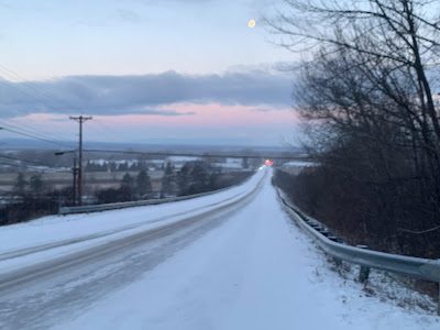
In this case, it was just a pretty hefty snow shower that passed by quickly, leaving partly cloudy skies and a dawn view of the moon in its wake.
But the snow showers definitely left behind a half inch ofd new snow and some very slick roads, making conditions pretty hazardous for some on their morning commute.
You'll want to take some extra time getting to work this morning especially if it snowed where you are.
The snow showers were hit and miss. Some areas were still fine, others a mess between 7 and 8 this morning. That state of affairs should last all day.
A weather disturbance and cold front is instigating the snow showers. They could hit anywhere anytime today, but the best chance is this afternoon and in central and northern Vermont, and the entire Green Mountain range.
Some of the snow showers, like the ones in St. Albans early today, will be on the heavy side. But they're racing along and should be pretty brief. Which means total accumulations will be an inch or less. The exception to this will be an area along and north of Route 2 from east of Burlington into New Hampshire, which could pick up one to three inches.
The Connecticut Valley of southeastern Vermont should see pretty much nothing at all. Meanwhile, the Green Mountains, especially from Killington north, should see two to as much as six inches out of this.
All this will make things unpredictable on the roads all day. Things will be fine one minute then they won't. Or, you'll be blissfully traveling along a snow-free road, only to encounter the next minute some low visibility snow, and ice under your tires.
This state of affairs should last through today's evening commute, so beware.
The rest of the week looks fairly quiet, but there are signs of some modest storminess Friday and perhaps something a little more substantial early next week. But the weather pattern is especially hard to predict right now, so any forecast beyond a couple days is suspect.
Just wait it out and check forecasts as they're updated.


No comments:
Post a Comment