 |
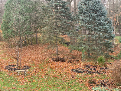
| Friday night's gusts to 40 mph took down almost all the remaining leaves on the trees around my St. Albans, Vermont yard, leaving the lawn carpeted in orange and brown. |
We've got another round of gusty winds Monday night and early Tuesday.
Summer and early fall in Vermont usually feature very little wind, except in strong thunderstorms. By fall, the winds pick up, especially in the Champlain Valley, as stronger large scale storms start to take hold.
Although it can be windy anywhere in Vermont this time of year and in the winter, the Champlain Valley is ground zero for gusty days and nights.
That's especially true this time of year. A typical November storm track is up through the Great Lakes and into Ontario and Quebec. That sets up south winds. The Green Mountains and Adirondacks act as a funnel, constricting the air and making move high speed south to north up the valley.
These windy spells are frequent, and it doesn't take a very strong storm system to produce them. One storm passed well to our northwest Friday night, producing gusts to and maybe even a little over 40 mph in spots.
It's been such a calm autumn until now that I was surprised how many small branches were on the ground after that windy spell Friday night. Weakened and dead twigs accumulated in trees during a remarkably wind-free summer and fall. The first windy night produced, an, um, windfall of downed small branches.
Nothing damaging of course. The winds weren't strong enough to cause much trouble. It did take down most of the remaining leaves on the trees. Most of the straggler leaves still clinging to the trees are about to blow off.
That's because another modest storm is coming along Monday night. Again, typical of November, this one is going by to our northwest. Though the storm isn't a biggie, the jet stream driving it is strong. That'll push that storm past us very fast, and perhaps mix down some higher speed air from aloft.
Not all of the region will get a blast of wind out of this, but it should be breezy everywhere Monday night.
The central and northern Champlain Valley should see gusts over 40 mph Monday night, so it will be rather noisy and bumpy and spooky outside overnight as the wind roars through the now bare trees and slams shed doors and shutters back and forth.
In the far northern Champlain Valley winds - say up toward St. Albans, Swanton, Alburgh, and other parts of the Islands - winds could gust to 50 mph. This might prompt a wind advisory because those gusts are strong enough to produce some scattered power outages.
I don't know anybody in their right mind who would be on top of Mount Mansfield overnight Monday and early Tuesday, but gusts up there should reach 65 mph, says the National Weather Service office in South Burlington.
Although the gusty winds coming up aren't due to any strong systems, sometimes the storms that roared through the Great Lakes are truly monsters - the famous Gales Of November. Those huge storms also cause very windy weather in Vermont, and throughout the eastern half of the United States.
Big November storms like that are what the song "The Wreck of the Edmund Fitzgerald," is about. It's the true story sung by Gordon Lightfoot about a ship that sank during a powerful storm in Lake Superior in November, 1975, claiming 29 lives.
Another famous November gale was in 1950, with a powerful storm that moved northeastward more along the Appalachians rather than the Great Lakes. That storm dumped one to as much as five feet of snow on places like Ohio, western Pennsylvania and West Virginia.
In the Northeast, that 1950 event is easily one of the worst wind storms in history. Gusts reached 160 mph atop Mount Washington, 110 mph in Concord, New Hampshire, 108 mph in Newark, New Jersey and 94 mph in New York City.
Here in Vermont, the 1950 storm brought the highest wind gust on record at Burlington, with 72 mph. We did come close to breaking that record last December 23rd with a gust to 71 mph in Burlington.
Nothing extreme like those storms is on the way anytime soon, so don't expect much drama. But if this November is anything close to normal, expect more hang on to your hat and bump in the night weather pretty frequently over the next few weeks.

No comments:
Post a Comment