Showing posts with label patterns. Show all posts

Tuesday, October 14, 2025

It's Been A Odd Tropical Storms, Hurricanes Season And The Weirdness Continues

Powerful Hurricane Erin in the central Atlantic Ocean
back on August 16. It's been a really weird 
hurrican
We're nearing the end of Atlantic hurricane season, with just a month and a half to go before things should get safer for another year. 

There's still a chance that more hurricanes could form and even threaten the United States. 

But as it stands now, we're lucky. So far at least, this is the first year since 2015 without a hurricane striking the U.S. coastline.

We needed the break. 

That's not to say tropical storms and hurricanes haven't messed with the U.S.

Moisture from brief, weak tropical storm Barry was a key ingredient into the horrible, deadly Texas floods over the Fourth of July weekend. 

Also in July, Tropical Storm Chantal splashed ashore in South Carolina in July, causing flooding in the Carolinas.

And, offshore Hurricanes Erin, Gabrielle and Humberto sent waves slamming into the U.S. East Coast, sending nearly a Outer Banks, North Carolina dozen homes crashing into the ocean.

This has been a weird hurricane season. It's always been go big or go home. Tropical systems in the Atlantic have either been brief, weak nothingburgers or monsters.

The monsters have all taken a turn north far offshore of the United States. Had this weather pattern been 400 or 500 miles further west, the East Coast would have been raked by repeated strong hurricanes. 

It's been weirder in recent weeks than earlier in the season. We had the drama of Hurricanes Humberto and Imelda setting a record for Atlantic hurricanes being so close to each other. That led to a strange dance between the two storms that changed their directions, and alternately strengthened and weakened both. 

Then we had Tropical Storm Jerry. The disturbance that became Jerry emerged from the west coast of Africa more than a week ago, That's awfully late in the season for something like that to happen.

The African disturbances that can turn into powerful hurricanes usually shut down by the end of September. 

Forecasters originally had high hopes for this storm, figuring Jerry would turn into a decent sized hurricane. But, strong upper level winds keep tearing the storm apart. It stayed a weak tropical storm until it dissipated over the middle of the Atlantic Ocean this past weekend.  

Then we had little-noticed Subtropical Storm Karen. 

Subtropical Storm Karen formed last Thursday, strangely far north in the Atlantic Ocean, at 44.5 degrees north 33 degrees west. That's about the same latitude as Nova Scotia. That's the furthest north such a storm has formed in at least 150 years. 

Subtropical storms are hybrids of the warm core storms that are true tropical storms and regular old storms that have warm and cold fronts and such. 

The water was actually "too cold" to support a tropical or subtropical storm. But because of a pocket of cold air high overhead was such a contrast to the tepid waters below that we were able to get Subtropical Storm Karen. 

It was so far north that its life was a short one. It dissipated Saturday. 

Now we have Tropical Storm Lorenzo, which outdid Jerry for being an incredibly late season African-born storm. 

As of this morning, Lorenzo was struggling just like Jerry did. Stronger upper level winds and dry air are tearing Lorenzo apart. If the storm survives these troubles, it'll head slowly northward and the northeastward out in the middle of the Atlantic.  It won't bother anyone. 

Some models bring a tropical storm or hurricane to the Caribbean Sea or far eastern Gulf of Mexico in a couple weeks, but those long range predictions are notoriously unreliable. 

Thursday, July 24, 2025

This Is The Year Of The Floods, And It Will Only Get Worse With Climate Change

Flash flood damage in Sutton, Vermont on July 10.
This summer has brought an extraordinary
number of flash floods to the U.S. Get used to it,
as this is the new climate change normal. 
The news of deadly, terrible floods have been coming at us pretty much daily lately.

It's the Summer Of Floods.  

And I'll get this out of the way right now. Yes, climate change is much share in the blame for all this.   A warmer atmosphere can hold more moisture than a cooler air. That extra warm air moisture is increasingly wrung out in extreme fashion if a summertime weather disturbance bumps into it. 

The Atlantic Ocean and Gulf of Mexico are both warmer than average, due again in large part due to climate change. Some of that warmer water evaporates into the air, which flows inland as exceptionally humid air, ripe for producing extraordinary downpours.

This isn't going away. And neither is the death, heartache, hardship and sadness the floods bring. Moreover, we're not ready for these things, and not ready for when they get worse. Which will happen.

On top of all that, the political climate in the U.S., such as it is, is not at all conducive for dealing with our new reality. 

What follows is our situation, and it isn't pretty.  

THE FLOODS

July began with the extreme Texas floods that are known to have killed at least 135 people.  Floods and debris flows swept Ruidoso, New Mexico on July 8, killing three people.  Another four people died in North Carolina flooding on July 6.

Davenport, Iowa endured a flash flood emergency on July 11. Another huge flash flood hit New Jersey and the New York City metro area on July 14 claiming an additional two lives. Flash flooding from five inches of rain returned to parts of New Jersey on July 20.  

Other dramatic floods have hit the western Chicago suburbs (July 8 ), the Kansas City area (July 17) parts of Virginia, (July. 18), the northern suburbs of Washington DC on July 19 and Overland Park, Kansas on July 21, where one person died. 

 In the United States, flood deaths last year and this year are far above the annual average of 85. In 2024, the U.S. saw 145 flood-related deaths.  The nation saw at least that many deaths from flooding just this month, never mind the whole year.   

The sheer number of floods this month have been staggering. 

Through mid-month, the National Weather Service had issued more flash flood warnings in the United States than in any year since at least 1986. When I last checked a couple days ago it was at least 3,360 such warnings and counting. 

Here in Vermont, we've so far escaped the worst of it, but we've still dealt with damaging flash floods this year. On May 17, there was quite a bit of flash flooding in towns like Warren, Waitsfield and White River Junction. 

Parts of the Northeast Kingdom were slammed by flash floods on July 10, seriously damaging some homes and several roads. 

TOO WET, TOO WARM

The bottom line of this summer is it's been too warm, and especially too humid. 

Per the Washington Post

"A Washington Post analysis of atmospheric data found a record amount of moisture flowing in the skies over the past year and a half, largely due to rising global temperatures. 

With so much warm, moist air to fuel storms, they are increasingly able to move water vapor from the oceans to locations hundred of miles from the coast, triggering flooding for which most inland communities are ill-prepared.

'We're living in a climate that we've never seen, and it keeps throwing us curveballs,' said Kathie Dell, North Carolina's state climatologist. 'How do you plan for the worst thing you've never seen?'" 

Most places aren't ready for this new, wet reality. Many coastal areas have elaborate systems to evacuate people and bolster defenses against severe storms and hurricanes, which have always been a hazard near the shore.

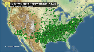
Each tiny green box in this map is one of the flash flood
warnings issued between January 1 and July 18 this year
Source: The Weather Network. 
Inland states, cities and towns are not as prepared for the extremes like the newly ferocious floods that now strike places like they did in western North Carolina during last September's Hurricane Helene, and the tragic floods in the Texas Hill Country in early July. 

We keep hearing these floods described as one in 1000 year events. That means there's just a 0.1 percent chance of that event happening in that place in any given year. 

However as CNN explains:

"But climate change is losing the dice in favor of extreme precipitation. 

'When we talk about e.g. 1,000 year events, we're talking about the likelihood of these events in the absence of human-caused warming (i.e, how often we would expect the from natural variability alone),' said climate scientist Michael Mann of the University of Pennsylvania. 'These events are of course much more frequent 'because' of human-caused warming,' he said in an email."

As the Washington Post points out, for every 1 degree Celsius (1.8 degrees Fahrenheit) of warming air is capable of holding 7 percent more moisture. 

That moisture has to go somewhere. Hence the floods,  Some climate scientists also increasingly think weather patterns can get "stuck" in place more often, due to climate change. 

CNN continues:

"A recent study Mann worked on found such weather patterns have tripled in incidence since the mid-with century during the summer months. The problem is these patterns are 'not necessarily well captured in climate models' he said. This increases uncertainty about future projections for extreme weather events."

WHAT TO DO?

This trend toward more and worse floods will only continue. 

Sure, some summers in the United States and elsewhere will be drier than this one.  A few future summers will feature punishing droughts. After all, depending on the prevailing weather patterns of the season, winds could come from dry sources like central Mexico, or the Desert Southwest. 

But overall, we are now permanent stuck in a world that floods more easily and more dramatically than ever before. And it will get worse.

We are not ready for that. 

As the Washington Post quoted:

"'Any given community can't know if it's going to be the next one that's going to  have a flood that is orders of magnitude larger than the largest flood they've known,' said disaster researcher Rachel Hogan Carr, who co-chairs a World Meteorological Organization project aimed at improving flood warnings. 'But we must all know now that we should be prepared.'"

One reason so many people died in Hurricane Helene - and the mega flood earlier this month in Texas, is that people couldn't imagine things would get that bad. And plans were not necessarily in place to deal with it. 

In western North Carolina, perhaps not enough people fled from the impending danger from the floods, as the Washington Post reported:

 "Though the National Weather Service correctly predicted that the flooding would be deadly, the warnings from local authorities were not forceful or specific enough to sway residents who never imagined a hurricane could hurt them so far from the sea."

The same problem came with the Texas flood. Meteorologists accurate predicted the torrential rains that brought the floods. But authorities didn't order evacuations in many of the hardest hit areas. And warnings didn't reach many until it was too late to flee. Some of those people died. 

The lesson: Detailed disaster plans need to be established, ones that take the warnings from the National Weather Service and get them to the people who need to hear them. And somehow, the public needs to be trained to heed these flash flood warnings, and know how to get out of the way quickly. 

I'm not optimistic we can get there anytime soon, given the Trump-era cutbacks and the National Weather Service and their laissez-faire approach to emergency management.   

THE AFTERMATH

For flood survivors, the mega floods leave incredible destruction that threaten the very existence of their communities.  

An example is Ellicott City, Maryland, a charming, old small city not far west of Baltimore, was devastated three times within a decade, first in 2011, then an even worse flash flood in 2016 and then the worst of them all in 2018,  

Once again, it rained hard in Ellicott City a couple weeks ago and the dreaded flash flood warnings were issued. Nearly 3.5 inches of rain pounded the community within three hours on July 13. Another 1.5 inches fell in less than an hour the next day. That's close to the amount of rain that devastated Ellicott City in 2018.

"When it rains like it did Monday and Sunday, a wave of fear comes over business owner Cindi Ryland told CBS Baltimore. 'What we go through here every time it rains, we all just hold our breath,' Ryland said. 'It's frightening, but we're here and we're resilient."

This time, the water caused only minor damage,  But only because of some painful and very expensive redesigns and rethinking in Ellicott City. 

Per CBS Baltimore: 

"The projects include five retention ponds, two of which are complete, and two water conveyance project, Those include a series of culverts under Maryland Avenue and the North Tunnel project

The third retention pond is expected to be up and running in the fall. The North Tunnel is expected to be complete by fall 2027 while the culvert are in their final design stage"

The changes already completed were apparently enough to prevent another catastrophic flood in Ellicott City this time.  

But the project came at a big financial and community loss, Ellicott City had to tear down four historic buildings. The cost is estimated at $130 million, which includes a $75 million loan from the federal Environmental Protection Agency and $20 million from the state of Maryland. 

This is just one community. Imagine how much it will cost to project dozens, or hundreds, or thousands of communities from the new flood regime we're under. 

There's echoes of Ellicott City parallels Vermont communities like Barre, hit hard by floods in both 2023 and 2024.

The 2023 flood damage 350 properties were damaged. Barre, among other things has been looking at buyouts.. Sixty-seven property owners jumped at the chance to sell their flood-prone properties. 

Those properties would be razed, and the remaining land would just become open floodplain. Maybe parks or farmland, but no houses, no commercial structures. 

This type of buyout, though, is painful to the communities involved. With each demolished house, Barre would lose some of its tax base. Right when the cash-strapped city is also trying to pay for flood recovery. 

It got so bad, that Barre rejected some applications for the buyouts. Barre's city manager said approving all the buyouts would  have gotten rid of roughly $280,000 in property tax revenue. 

Barre isn't a rich little city either, About a quarter of the residents are at or below the poverty level. Plus Barre needs more housing, not less. At last report, the city rejected 40 of the 27 buyout requests. 

Now imagine how many Barres are out there. It's challenging!  

NO TRUMP HELP

To make things worse, the Trump administration is clawing back money set for these flood mitigation projects. Basically, since Trump doesn't think climate change exists, there's no need for the funding. 

It also interesting that Trump signed this into law back in 2018 and now he's dumping the idea 

Virtually all climate scientists disagree with Trump, but the narcissist in chief insists he's always right, so there you go.

Anyway, 20 states, including Vermont, are suing the Trump administration's  decision a couple  months back to end a multi-billion dollar federal program that helps communities gird themselves against future floods as Vermont Public reports.   

The program is called Building Resilient Infrastructure and Communities (BRIC). It covered as much as 90 percent of the cost of things like restoring floodplains, expanding and improving culverts and bridges and protecting wastewater and drinking water treatment plants  

 It looks like Vermont was supposed to get about $5 million in funding through BRIC this year to fund 36 projects around the state.  

So, the floods are going to continue and get worse, and the tools are being taken away from us to deal with that wet future.

Everything is backwards these days.  

Monday, June 3, 2024

"Chamber Of Commerce" Vermont Weather To Slowly Be Replaced By Lots Of Rain Chances

Thanks to my husband's hard work, our deck is all
set for us to enjoy the "Chamber of Commerce" 
weather we've been having lately. 
Since Thursday afternoon, most of Vermont has been enjoying what is known as Chamber of Commerce weather. 

You know what that means. Sunny days, low humidity, comfortable temperatures. It's the kind of conditions that definitely keep tourists happy, not to mention the locals.

 This type of weather keeps the cash flowing, as people want to be out and about and doing things in this great sunshine and comfortable temperatures. 

Enjoy it for a couple more days, as the bright sunshine will eventually fade into showers. 

One pretty interesting thing that happened both Saturday and Sunday afternoon is how the sun's heat created updrafts, which poked up to several thousand feet overhead. The atmosphere was dry throughout,   so that didn't generate any clouds or showers like what might happen on a humid day. 

The air aloft was even drier. Desert dry.   The updrafts made some of that upper level super dry air mix down. So in the mid-afternoon, the low humidity we were already experiencing really crashed. 

Dew points - a  rough measure of how humid the air feels -  fell into the 30s both weekend afternoons. That's super low for this time of year. For a comparison, if the dew point is at 60 degrees, it begins to feel a little humid-ish. Dew points in the 50s are considered very comfortable during the summer. 

Dry air can heat up much faster than humid air. So when the humidity crashed, temperatures rocketed right up into the 80s both afternoons. This type of situation is par for the course in deserts, but it a fun quirk to watch here in Vermont

TRANSITIONS

The weather pattern is gradually transitioning and we'll eventually have to say goodbye to that Chamber of Commerce weather for now. 

One reason why the weather is staying so nice for so long is that summer weather patterns don't change nearly as quickly as they do in the winter. But it does change. The whole set up over the United States will slowly shift eastward, eventually setting the Northeast up for a long spell of showery weather. Meanwhile, heat will build in what was previously the cool and unsettled western United States.

The first phase of that will make things even a little more summery for the next couple of days.  The sun will mostly stay out today, tomorrow and to an extent Wednesday, but the air will start to feel ever so slightly more humid, and still quite warm. The humidity will still be in the comfortable zone, but it won't crash as much in the afternoons as it did during the weekend.

And we'll start to hear about shower chances. There's an ever so slight chance of an isolated shower, mostly over the mountains Tuesday afternoon. We have a slightly better chance Wednesday, though the majority of us will stay dry that day, too.

As the new pattern establishes itself, we might finally get wet Thursday. By then, we will have needed the rain, because most of us will have been dry for a week.  It's still unclear how much rain we'll see Thursday, and what time of day will see the bulk of it. 

It's also still unclear if it will rain Thursday. Some models keep things to our west until Friday or even Saturday. Stay tuned. 

Given the slow pace of June weather shifts, the cooler, wetter regime should stick around all weekend and probably most of next week.  I'm not how cool it will get, but I don't expect anything that out of whack for this time of year. Chances are, it could even be fairly close to  normal. Again, we'll need updated forecasts to figure that one out. 

I don't think any given day after Thursday will be a washout, but there will be daily chances of showers. The distribution of showers and how much rain we'll see each day depends on the arrangement of small weather disturbances within this vast area of unsettled weather over the Northeast. It's way too soon to forecast those fussy details. 

The heat wave that is building in the West looks like it will be a record breaker in many areas. Climatologists and long range forecasters have been predicting blockbuster heat waves this summer in the U.S.

That prediction already seems to be coming true. 

We've already had impressive early season heat in Texas and Florida, and now it's the western United States' turn. 

We'll avoid heat waves in Vermont through the middle of June, but there's still plenty of time after that for hot weather. We're still obviously waiting to see how all that sugars out.


Tuesday, April 23, 2024

More Vermont Fire Risk Before Wintry Blast, Hard Freeze, Then Spring

Lots of wannabe lilac blooms on my big lilac
shrub in front of my St. Albans, Vermont house. 
Crossing my fingers they will survive 
Wednesday night's expected hard freeze.
 You can certainly tell at dawn this morning where the first stirrings of a warming south wind had started and where it was still calm and cold.  

It was in the low 40s in the Champlain Valley where a steady south wind was already blowing, but in the mid-20s elsewhere in Vermont after a clear, calm night. 

Those south winds will increase areawide today, giving us a quick squirt of warm air before winter unfortunately returns for a brief visit. 

The air is still really dry and is expected to stay that way all day. Winds gusting to 30 mph continues the fire danger that started yesterday.  

Yes, it's muddy underfoot still, and there's vernal pools in the woods. But the dead grass and leaves from last autumn have dried out in the sun. That's what can catch fire. Those fires can spread fast in today's winds. 

So, for the second day in a row, the Vermont Department of Forests, Parks and Recreation has us in a high fire danger for the day. 

WINTER

The kind of respite from this brief period of fire risk is not the kind we want. 

Rain will break out overnight, then change to snow - yes, snow - during the afternoon Wednesday. That's normally the warmest time of day this time of year, when temperatures should be approaching 60 degrees.

Not on Wednesday! Temperatures in the 40s will crash through the 30s in the afternoon.  Snow will accumulate even in many of the valleys. Not much, though. Perhaps a dusting to an inch.  But it's still harsh. 

That's not the real problem this time of year. It's the temperatures. 

These lilac buds died and failed to bloom after
this harsh winter storm and freeze in April, 2021
Not nearly as much snow as that episode is expected
with the upcoming freeze, but temperatures will
fall far into the 20s by Thursday morning.
Coldest hollows will be in the upper teens. 

They'll go below freezing in the late afternoon and evening and stay subfreezing into Thursday morning.

 Skies will quickly clear and winds will die down overnight. That means lows by Thursday morning ranging from around 18 in the cold spots to maybe 30 degrees right next to Lake Champlain.

That puts most of us in the 22 to 27 degree range. 

That's similar to the horribly damaging freeze of last May 18. Thankfully, plants and trees aren't nearly as far along now as they were last May. 

Trees haven't leafed out.  Fruit trees aren't flowering yet. So damage this time will be much less.  Those orchards are budding for sure, but fingers crossed I think most (but perhaps not all) of those buds should make it through this cold snap. 

Vineyards are probably relatively safe, too.

Because it is before the official growing season, there won't be any freeze warnings in Vermont with this. We should be glad this frigid episode isn't happening a couple weeks later than it is.

Still, this might be a disheartening spell for gardeners, like me. If your magnolia tree is blooming and those blooms survived this morning's freeze, enjoy them today. Those blooms will be brown wreckage by Thursday. 

It'll be interesting to see how hardier early plants do. My lilacs have tons of flower buds, more than in most years, so I was looking forward to a huge lilac season.  

I do worry this will be like 2021, when my lilac buds ended up failing to flower after dying in a harsh snowstorm and deep freeze. We shall see, but I'm not super optimistic. 

This is turning out to be yet another spring in which plants outside start to bud and blossom too early because of oddly warm weather. Then a harsh freeze threatens them. It's become a depressing spring pattern. With this frigid spell, it will be the fifth year in a row it's happened, with varying degrees of damage. Mostly relatively minor, except for last year. 

It's the new, changed climate.  It's generally warmer than it used to be, so spring advances earlier than it once did. But the new climate is also more extreme, so we get these brief blasts of winter air to cause potential damage. 

SPRING 

These spring cold blasts are always very brief, and this one will be no exception. Thursday will be cold for the season, with highs in the 40s, and another nasty frost/freeze is likely Thursday night. Though it won't be as cold as the night before.

By Friday afternoon, we'll be well into the 50s, Saturday will see highs passing 60 degrees and we could get into the low 70s by Sunday or Monday.  


Saturday, March 16, 2024

Tornado Damage: Why Is One House Destroyed, While Next Door Neighbor Is Fine?

Tornado damage in Hanover, Indiana Thursday.
The destroyed house was likely hit by a subvortice
within the main tornado. That subvortice
missed the house next door, which looks fine. 
 I'm sure a lot of you have noticed it. 

Whenever there's news of a damaging tornado on TV, you'll often see one house blown to pieces while the next door neighbor's home looks fine. 

I've always been fascinated (with a sense of dread) of that kind of thing. The luck of the draw. The fickle finger of fate. Something like that. 

There's actually a well-known scientific reason for this pattern of destruction. To understand it, you need to picture a Tilt-A-Whirl at the county fair. 

There's a video of a Tilt-A-Whirl if you click on this link.  The entire amusement park ride is rotating, while individual car also spins. Notice how the car usually spins faster when the direction of the spin is the same as the ride's spin.

The cars on the Tilt-A-Whirl spin more slowly when its rotation is in the opposite direction of the overall ride.

The house on the left was likely destroyed by a subvortice
within a parent tornado. The house across the street was
damaged more by debris from the destroyed home than
the actual wind. Other houses in the 
neighborhood look nearly unscathed. 
In one respect, tornadoes are often giant Tilt-A-Whirls.  You have one rotating tornado, the ride itself. Inside that tornado are what are known as subvortices or suction vortices.

These vortices are little tornadoes circulating within the main twister. They are the "cars" on the Tilt-A-Whirl.

Just like those Tilt-A-Whirl cars, the wind speed is much stronger in the part of the subvortice that is spinning in the same direction as the main tornado. 

Winds are lighter in the part of the vortices that's rotating in the opposite direction of the big tornado it's playing with. 

 These subvortices are small, often just a few yards wide. The result of all this is you get little lines or arcs of severe damage where the subvortice was spinning in the same direction as the tornado.

 These little streaks of damage can be the result of winds blowing as much as 100 mph more than in the general circulation of the main twister

Which is why you see one house destroyed by a tornado while the next door neighbor pretty much has to rake up a few leaves to clean up after the storm. 

Unless the subvortice flings debris at something or someone. Sometimes, like in the second photo in this post, the debris from a house destroyed by a suction vortices smacks into the neighbor's house, causing damage there as well. 

 It's unknown what percentage of tornadoes have these subvortices, but it's a lot. Maybe even most tornadoes.

They're usually hard to see, but if a tornado hasn't really condensed into a thick funnel, you can often see the subvortices dancing around the main circulation. 

Famous storm chaser Reed Timmer has a video of tornadoes with quite visible sub-vortices to give you an idea how they act. Click on this link to view, or if you see the the image below, click on that. 


Wednesday, March 13, 2024

Vermont Spring Weather Bursts Forth Again, At Least For Now

Deep blue skies and fresh white snow cover in
Bakersfield, Vermont Tuesday on a spectacularly
bright and gorgeous March day. 
 Wasn't Tuesday's weather absolutely spectacular?   

The sky was the deepest blue imaginable. In places that received a lot of snow earlier this week the white gleamed in the bright, high angle sunshine of March.  

Near Lake Champlain, the lack of snow cover really helped the day warm up.

Everywhere, the combination of the subfreezing weather Sunday and Monday and the warm sunshine of Tuesday had sugar makers super busy, which is a good sign.  

I noticed a couple of interesting things going on yesterday. Satellite photos showed thick snow cover in most of Vermont. The immediate Champlain Valley, places right along the Connecticut River and in some low lands in southwestern Vermont the ground was free of snow.

The satellite picture exactly matched the National Weather Service map of actual snow totals.  Only a couple inches fell in low spots, which quickly melted. Up to a foot and a half fell along the west slopes of the Greens.

Satellite photo with clear skies Tuesday shows 
snow cover in the Adirondacks, most of 
Vermont outside the warmer valleys and
in western New Hampshire. 
The snow cover, or lack of it had a noticeable effect on daytime temperatures Tuesday.

 In areas with no snow, the bare ground absorbed the bright sun's heat and temperatures soared into the low 50s. 

In other areas, the fresh snow cover bounced the sun's heat back out to space to some extent, so temperatures there held mostly around 40 degrees. 

It just demonstrate to show that if you have an early spring with little snow on the ground, chances are you also have a rather warm early spring. Which is what we've had so far. 

That state of affairs should continue into the weekend, even in areas that have a snow cover. Which will be waning anyway.

Outlook

We had another freeze last night, so that should again help those out there sugaring. However, many of us will once again stay above freezing from now until at least Sunday night.  

Those long stretches of warm nights we have had have all winter and early spring have interfered with sugaring and the winter sports industry. Plus has created our never ending mud season, which essentially started in January. 

High temperatures will reach to within a few degrees either side of 50 degrees today and tomorrow, which is definitely on the mild side for mid-March. Even this weekend, highs will "only" be in the mid and upper 40s, which is still a bit on the balmy side for the period around St. Patrick's Day. 

National Weather Service map of snow totals from
the storm we just had matches the satellite photo 
above. Where little snow fell, the ground is
already bare. Where it was heavy, the ground gleams
white with snow, at least for now. 
Tuesday would have been a great day for a solar eclipse, but alas, we'll have to pray for similar weather on April 8, when the actual eclipse gets here.

The blue skies of Tuesday are gone, in favor of a mix of clouds and sun. More rain is in the forecast, so that will worsen our long slog through mud season.

In Burlington, it's not even quite mid month and we've already had very close to what is normal precipitation for the entire month. The upcoming rains won't be especially heavy.

With snow melt and the lighter rains rivers and streams will probably get high or stay that way, but we won't have enough rain to create huge flood problems.. Just more mud.

The best chances of rain are Thursday night and Friday, and again probably on Sunday.  We'll probably see a couple days of pretty chilly weather starting Monday, as it looks now. 

Laughable Computer Model

The following will almost certainly not happen, but it's an illustration of how I am sometimes entertained by long range forecasts. It's especially a cautionary tale as to why you should't believe weather forecasts beyond, say, five days out. 

The American computer model depicts a mega-storm affecting the Northeast, including Vermont around March 26. But the model's evolution of the proposed storm makes absolutely no sense.  It also has the storm going by far to the south of Vermont, but still somehow flinging three or four  inches of rain our way. 

By Wednesday the 27th, it has the storm something like 400 or 500 miles of the New England coast and still giving Vermont heavy precipitation.  Yeah, right.

I suppose there might be some sort of storminess toward the end of March, and these long range forecasts are sort OK for giving a hint at future weather patterns. But the specifics? Hah!  That American computer model was drinking way too much vodka when it came up with the storm forecast for March 26-27.

It ain't going to happen. 


Sunday, November 5, 2023

The Gales Of November (Well Sort Of) Have Arrived

Friday night's gusts to 40 mph took down almost all
the remaining leaves on the trees around my 
St. Albans, Vermont yard, leaving the lawn 
carpeted in orange and brown.
 It was a little late in coming, but the usual windy cold season regime finally arrived in Vermont Friday, which featured a very gusty night in the Champlain Valley. 

We've got another round of gusty winds Monday night and early Tuesday. 

Summer and early fall in Vermont usually feature very little wind, except in strong thunderstorms. By fall, the winds pick up, especially in the Champlain Valley, as stronger large scale storms start to take hold. 

Although it can be windy anywhere in Vermont this time of year and in the winter, the Champlain Valley is ground zero for gusty days and nights. 

That's especially true this time of year. A typical November storm track is up through the Great Lakes and into Ontario and Quebec. That sets up south winds.  The Green Mountains and Adirondacks act as a funnel, constricting the air and making move high speed south to north up the valley. 

These windy spells are frequent, and it doesn't take a very strong storm system to produce them.  One storm passed well to our  northwest Friday night, producing gusts to and maybe even a little over 40 mph in spots. 

It's been such a calm autumn until now that I was surprised how many small branches were on the ground after that windy spell Friday night. Weakened and dead twigs accumulated in trees during a remarkably wind-free summer and fall. The first windy night produced, an, um, windfall of downed small branches. 

Nothing damaging of course. The winds weren't strong enough to cause much trouble.  It did take down most of the remaining leaves on the trees. Most of the straggler leaves still clinging to the trees are about to blow off. 

That's because another modest storm is coming along Monday night. Again, typical of November, this one is going by to our northwest. Though the storm isn't a biggie, the jet stream driving it is strong.  That'll push that storm past us very fast, and perhaps mix down some higher speed air from aloft. 

Not all of the region will get a blast of wind out of this, but it should be breezy everywhere Monday night. 

The central and northern Champlain Valley should see gusts over 40 mph Monday night, so it will be rather noisy and bumpy and spooky outside overnight as the wind roars through the now bare trees and slams shed doors and shutters back and forth. 

In the far northern Champlain Valley winds - say up toward St. Albans, Swanton, Alburgh, and other parts of the Islands - winds could gust to 50 mph.  This might prompt a wind advisory because those gusts are strong enough to produce some scattered power outages. 

I don't know anybody in their right mind who would be on top of Mount Mansfield overnight Monday and early Tuesday, but gusts up there should reach 65 mph, says the National Weather Service office in South Burlington. 

Although the gusty winds coming up aren't due to any strong systems, sometimes the storms that roared through the Great Lakes are truly monsters - the famous Gales Of November. Those huge storms also cause very windy weather in Vermont, and throughout the eastern half of the United States.

Big November storms like that are what the song "The Wreck of the Edmund Fitzgerald,"  is about. It's the true story sung by Gordon Lightfoot about a ship that sank during a powerful storm in Lake Superior in November, 1975, claiming 29 lives.

Another famous November gale was in 1950, with a powerful storm that moved northeastward more along the Appalachians rather than the Great Lakes.  That storm dumped one to as much as five feet of snow on places like Ohio, western Pennsylvania and West Virginia. 

In the Northeast, that 1950 event is easily one of the worst wind storms in history. Gusts reached 160 mph atop Mount Washington, 110 mph in Concord, New Hampshire, 108 mph in Newark, New Jersey and 94 mph in New York City. 

Here in Vermont, the 1950 storm brought the highest wind gust on record at Burlington, with 72 mph. We did come close to breaking that record last December 23rd with a gust to 71 mph in Burlington. 

Nothing extreme like those storms is on the way anytime soon, so don't expect much drama. But if this November is anything close to normal, expect more hang on to your hat and bump in the night weather pretty frequently over the next few weeks.