Showing posts with label preparedness. Show all posts

Sunday, January 18, 2026

Minnesotans Find Ally In Frigid Weather In Battle Against ICE

The now-infamous image of the ICE agent slipping
and falling on an icy Minneapolis street has become
a symbol of how winter-tough Minnesotans
are enduring the battle against ICE
oppression much better than the federal
forces in town to take away all the immigrants
The Battle of Minnesota between federal ICE agents and the good people of Minneapolis and other cities rages on. 

The citizens of frigid Minnesota have discovered they have one key ally in their struggle against the excesses of these often out of control federal agents. Winter. Including the regular slippery, not Gestapo ice, as in frozen water. 

Minneapolis has so far had the kind of winter we've had here in Vermont. Lots of freeze/thaw cycles and bouts of freezing rain to make everything even more interesting underfoot.

Judging from the videos of ICE agents slipping and falling on the ice, much to the delight of their many critics, I think the boots issued to ICE agents weren't exactly made for a Minnesota winter. 

Very much like Vermonters, Minnesotans know instinctively how to deal with winter. How to dress for it, how to embrace the cold. As The Other 98% wrote on Facebook:

"Beyond the spectacle of agents in tactical gear skidding on black ice, this moment reveals something deeper about the confrontation: A clash between a highly militarized federal apparatus and a community rooted in lived experience.

Many protestors have come equipped with insulated gear, boots with traction spikes and the kind of winter sense from years of Minnesota cold rather than federal training manuals. That difference - lived winter resilience versus bureaucratic enforcement - is playing out in real time on city streets."

Demonstrators are also using winter as a tactical tool against ICE, and against at least one right wind agitator who came to Minneapolis, and quickly fled. 

A constant hot spot in the Minneapolis unrest is the Whipple Federal Building, where ICE agents are headquartered. The weather turned much colder in the past few days in Minnesota. Protestors dumped water on the pavement near the building to form ice that could hinder, or at least annoy ICE agents. 

ICE ended up arresting four people, who they called "agitators" for "refusing to disperse." It appears ICE was irritated that they (allegedly) "threw objects, shouted profanities and endangered  the public by pouring water on the roads to create icy, hazardous conditions."

Judging from those ICE falling on ice videos I mentioned, the water on road idea just might be effective. 

On Saturday, Jake Lang, a right-wing nut and pardoned January 6 rioter, tried to lead an anti-immigration demonstration in Minneapolis, but hundreds of Minnesotans did not want to put up with his garbage. 

So, they chased Lang out of town, throwing punches at him, which I'm a little concerned about, and spraying him with water from squirt guns, which I'm not even a little concerned about. Temperatures hovered near 10 degrees at the time, and Lang did not appear dressed for the weather. 

Although video showed a little blood coming out of the back of Lang's head, he reportedly was not seriously injured. But I bet he was damn cold. 

Meanwhile, Trump is toying with the idea of invoking the Insurrection Act to deploy 1,500 federal troops to Minnesota. 

Critics, and there are a lot of 'em, say doing that would just escalate the uproar over ICE raids, at least some of which look legally dubious. It also appears ICE agents' interactions with protestors aren't always kosher, either.

In any event, the Pentagon is ordering about 1,500 active duty soldiers to get ready for what might end up as a deployment to Minnesota. The soldiers are with the Army's Alaska-based 11th Airborne Division, which specializes in cold-weather operations. 

 It looks like the Trump administration is beginning to notice the difficulty of dealing with a northern winter.  

Minnesota weather is now frigid and getting colder. Temperatures are only in the single digits with snow falling today. It'll be below zero tonight. An even stronger Arctic blast is due in Minnesota by next weekend.  

People out in the streets are rooting for the Arctic blast. The New York Times quoted Chris Foreman, a military veteran who has joined the protestors near the Whipple Federal Building: "I want it to get cold.....People know that a lot of these ICE guys are from the South. They're coming into a different environment and they're not used to it."

Frigid weather tends to slow things down. I hope that the Arctic cold will bring the temperature down figuratively as well as literally. 

Monday, August 11, 2025

Tropical Storm Erin Forms, Expected To Be Big Hurricane, But Where Will It Go?

Tropical Storm Erin in the far eastern Atlantic Ocean
doesn't look like much in satellite photos just yet,
but forecasters expect it to grow into a pretty 
powerful hurricane. No word yet on whether it 
would eventually threaten the United States.
 Tropical Storm Erin formed in the far eastern Atlantic Ocean today. This one will be the first biggie of the Atlantic hurricane season.  

But what Erin does and where it goes is still a big question. 

Since it was just forming, Erin is - for now - pretty week - with top winds of 45 mph.  Meteorologists at the National Hurricane Center said they think Erin will at first struggle against dry air and ocean water temperatures only barely warm enough to maintain a tropical system.

But as Erin moves westward, it'll encounter more humid air and ocean water that is much warmer.

 The water temperature isn't at record high levels as they were in 2023 and 2024.  But that temperature is well above normal and can easily support a strong hurricane,

The early guess is by Saturday morning, a rather powerful Hurricane Erin might be somewhere north of the Leeward Islands.

But then where will it go?

Many, but not all of the computer models are kind of encouraging. They turn Erin northward while it's well north of Puerto Rico and send it off into the middle of the Atlantic Ocean, far off the U.S. East Coast. 

The current track forecast for Erin, It's depicted as a 
major hurricane well northeast of Puerto Rico on
Saturday. It might turn north after that, but 
meteorologists are still unsure. 
But not all models do that. Some bring Erin to near Florida. And remember, it'll be a week or more before Erin will have any opportunity to approach the U.S.   So many things can change in that time frame that could conceivably take Erin anywhere from the Gulf of Mexico, to anywhere along the U.S. or Canadian east coasts, or, as I mentioned harmlessly out to sea.

Obviously we're rooting for the harmlessly out to sea option. 

It's not worth panicking over Erin because any United States impacts it might have are far, far away. There's lots of time to watch this thing. 

As the National Hurricane Center notes, this is only the beginning of peak hurricane season. 

Even if Erin ultimately misses the U.S., it's a great excuse to prepare for the season, and make sure you have everything you need and plans in place in case a hurricane threatens later this summer or fall. 

Erin is brand new and it has already caused trouble. Even before it was officially a tropical storm, it set off serious flooding in the Cabo Verde islands, where six people were reportedly killed.  Homes, businesses and vehicles on the islands sustained serious damage. 

The Cabo Verde islands are roughly 400 miles west of the westernmost point in the continent of Africa.  

Thursday, July 24, 2025

This Is The Year Of The Floods, And It Will Only Get Worse With Climate Change

Flash flood damage in Sutton, Vermont on July 10.
This summer has brought an extraordinary
number of flash floods to the U.S. Get used to it,
as this is the new climate change normal. 
The news of deadly, terrible floods have been coming at us pretty much daily lately.

It's the Summer Of Floods.  

And I'll get this out of the way right now. Yes, climate change is much share in the blame for all this.   A warmer atmosphere can hold more moisture than a cooler air. That extra warm air moisture is increasingly wrung out in extreme fashion if a summertime weather disturbance bumps into it. 

The Atlantic Ocean and Gulf of Mexico are both warmer than average, due again in large part due to climate change. Some of that warmer water evaporates into the air, which flows inland as exceptionally humid air, ripe for producing extraordinary downpours.

This isn't going away. And neither is the death, heartache, hardship and sadness the floods bring. Moreover, we're not ready for these things, and not ready for when they get worse. Which will happen.

On top of all that, the political climate in the U.S., such as it is, is not at all conducive for dealing with our new reality. 

What follows is our situation, and it isn't pretty.  

THE FLOODS

July began with the extreme Texas floods that are known to have killed at least 135 people.  Floods and debris flows swept Ruidoso, New Mexico on July 8, killing three people.  Another four people died in North Carolina flooding on July 6.

Davenport, Iowa endured a flash flood emergency on July 11. Another huge flash flood hit New Jersey and the New York City metro area on July 14 claiming an additional two lives. Flash flooding from five inches of rain returned to parts of New Jersey on July 20.  

Other dramatic floods have hit the western Chicago suburbs (July 8 ), the Kansas City area (July 17) parts of Virginia, (July. 18), the northern suburbs of Washington DC on July 19 and Overland Park, Kansas on July 21, where one person died. 

 In the United States, flood deaths last year and this year are far above the annual average of 85. In 2024, the U.S. saw 145 flood-related deaths.  The nation saw at least that many deaths from flooding just this month, never mind the whole year.   

The sheer number of floods this month have been staggering. 

Through mid-month, the National Weather Service had issued more flash flood warnings in the United States than in any year since at least 1986. When I last checked a couple days ago it was at least 3,360 such warnings and counting. 

Here in Vermont, we've so far escaped the worst of it, but we've still dealt with damaging flash floods this year. On May 17, there was quite a bit of flash flooding in towns like Warren, Waitsfield and White River Junction. 

Parts of the Northeast Kingdom were slammed by flash floods on July 10, seriously damaging some homes and several roads. 

TOO WET, TOO WARM

The bottom line of this summer is it's been too warm, and especially too humid. 

Per the Washington Post

"A Washington Post analysis of atmospheric data found a record amount of moisture flowing in the skies over the past year and a half, largely due to rising global temperatures. 

With so much warm, moist air to fuel storms, they are increasingly able to move water vapor from the oceans to locations hundred of miles from the coast, triggering flooding for which most inland communities are ill-prepared.

'We're living in a climate that we've never seen, and it keeps throwing us curveballs,' said Kathie Dell, North Carolina's state climatologist. 'How do you plan for the worst thing you've never seen?'" 

Most places aren't ready for this new, wet reality. Many coastal areas have elaborate systems to evacuate people and bolster defenses against severe storms and hurricanes, which have always been a hazard near the shore.
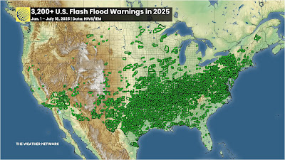
Each tiny green box in this map is one of the flash flood
warnings issued between January 1 and July 18 this year
Source: The Weather Network. 
Inland states, cities and towns are not as prepared for the extremes like the newly ferocious floods that now strike places like they did in western North Carolina during last September's Hurricane Helene, and the tragic floods in the Texas Hill Country in early July. 

We keep hearing these floods described as one in 1000 year events. That means there's just a 0.1 percent chance of that event happening in that place in any given year. 

However as CNN explains:

"But climate change is losing the dice in favor of extreme precipitation. 

'When we talk about e.g. 1,000 year events, we're talking about the likelihood of these events in the absence of human-caused warming (i.e, how often we would expect the from natural variability alone),' said climate scientist Michael Mann of the University of Pennsylvania. 'These events are of course much more frequent 'because' of human-caused warming,' he said in an email."

As the Washington Post points out, for every 1 degree Celsius (1.8 degrees Fahrenheit) of warming air is capable of holding 7 percent more moisture. 

That moisture has to go somewhere. Hence the floods,  Some climate scientists also increasingly think weather patterns can get "stuck" in place more often, due to climate change. 

CNN continues:

"A recent study Mann worked on found such weather patterns have tripled in incidence since the mid-with century during the summer months. The problem is these patterns are 'not necessarily well captured in climate models' he said. This increases uncertainty about future projections for extreme weather events."

WHAT TO DO?

This trend toward more and worse floods will only continue. 

Sure, some summers in the United States and elsewhere will be drier than this one.  A few future summers will feature punishing droughts. After all, depending on the prevailing weather patterns of the season, winds could come from dry sources like central Mexico, or the Desert Southwest. 

But overall, we are now permanent stuck in a world that floods more easily and more dramatically than ever before. And it will get worse.

We are not ready for that. 

As the Washington Post quoted:

"'Any given community can't know if it's going to be the next one that's going to  have a flood that is orders of magnitude larger than the largest flood they've known,' said disaster researcher Rachel Hogan Carr, who co-chairs a World Meteorological Organization project aimed at improving flood warnings. 'But we must all know now that we should be prepared.'"

One reason so many people died in Hurricane Helene - and the mega flood earlier this month in Texas, is that people couldn't imagine things would get that bad. And plans were not necessarily in place to deal with it. 

In western North Carolina, perhaps not enough people fled from the impending danger from the floods, as the Washington Post reported:

 "Though the National Weather Service correctly predicted that the flooding would be deadly, the warnings from local authorities were not forceful or specific enough to sway residents who never imagined a hurricane could hurt them so far from the sea."

The same problem came with the Texas flood. Meteorologists accurate predicted the torrential rains that brought the floods. But authorities didn't order evacuations in many of the hardest hit areas. And warnings didn't reach many until it was too late to flee. Some of those people died. 

The lesson: Detailed disaster plans need to be established, ones that take the warnings from the National Weather Service and get them to the people who need to hear them. And somehow, the public needs to be trained to heed these flash flood warnings, and know how to get out of the way quickly. 

I'm not optimistic we can get there anytime soon, given the Trump-era cutbacks and the National Weather Service and their laissez-faire approach to emergency management.   

THE AFTERMATH

For flood survivors, the mega floods leave incredible destruction that threaten the very existence of their communities.  

An example is Ellicott City, Maryland, a charming, old small city not far west of Baltimore, was devastated three times within a decade, first in 2011, then an even worse flash flood in 2016 and then the worst of them all in 2018,  

Once again, it rained hard in Ellicott City a couple weeks ago and the dreaded flash flood warnings were issued. Nearly 3.5 inches of rain pounded the community within three hours on July 13. Another 1.5 inches fell in less than an hour the next day. That's close to the amount of rain that devastated Ellicott City in 2018.

"When it rains like it did Monday and Sunday, a wave of fear comes over business owner Cindi Ryland told CBS Baltimore. 'What we go through here every time it rains, we all just hold our breath,' Ryland said. 'It's frightening, but we're here and we're resilient."

This time, the water caused only minor damage,  But only because of some painful and very expensive redesigns and rethinking in Ellicott City. 

Per CBS Baltimore: 

"The projects include five retention ponds, two of which are complete, and two water conveyance project, Those include a series of culverts under Maryland Avenue and the North Tunnel project

The third retention pond is expected to be up and running in the fall. The North Tunnel is expected to be complete by fall 2027 while the culvert are in their final design stage"

The changes already completed were apparently enough to prevent another catastrophic flood in Ellicott City this time.  

But the project came at a big financial and community loss, Ellicott City had to tear down four historic buildings. The cost is estimated at $130 million, which includes a $75 million loan from the federal Environmental Protection Agency and $20 million from the state of Maryland. 

This is just one community. Imagine how much it will cost to project dozens, or hundreds, or thousands of communities from the new flood regime we're under. 

There's echoes of Ellicott City parallels Vermont communities like Barre, hit hard by floods in both 2023 and 2024.

The 2023 flood damage 350 properties were damaged. Barre, among other things has been looking at buyouts.. Sixty-seven property owners jumped at the chance to sell their flood-prone properties. 

Those properties would be razed, and the remaining land would just become open floodplain. Maybe parks or farmland, but no houses, no commercial structures. 

This type of buyout, though, is painful to the communities involved. With each demolished house, Barre would lose some of its tax base. Right when the cash-strapped city is also trying to pay for flood recovery. 

It got so bad, that Barre rejected some applications for the buyouts. Barre's city manager said approving all the buyouts would  have gotten rid of roughly $280,000 in property tax revenue. 

Barre isn't a rich little city either, About a quarter of the residents are at or below the poverty level. Plus Barre needs more housing, not less. At last report, the city rejected 40 of the 27 buyout requests. 

Now imagine how many Barres are out there. It's challenging!  

NO TRUMP HELP

To make things worse, the Trump administration is clawing back money set for these flood mitigation projects. Basically, since Trump doesn't think climate change exists, there's no need for the funding. 

It also interesting that Trump signed this into law back in 2018 and now he's dumping the idea 

Virtually all climate scientists disagree with Trump, but the narcissist in chief insists he's always right, so there you go.

Anyway, 20 states, including Vermont, are suing the Trump administration's  decision a couple  months back to end a multi-billion dollar federal program that helps communities gird themselves against future floods as Vermont Public reports.   

The program is called Building Resilient Infrastructure and Communities (BRIC). It covered as much as 90 percent of the cost of things like restoring floodplains, expanding and improving culverts and bridges and protecting wastewater and drinking water treatment plants  

 It looks like Vermont was supposed to get about $5 million in funding through BRIC this year to fund 36 projects around the state.  

So, the floods are going to continue and get worse, and the tools are being taken away from us to deal with that wet future.

Everything is backwards these days.  

Friday, July 11, 2025

Latest Vermont Flood: Details Emerge As Questions Grow About FEMA

Map of rainfall yesterday in Vermont, from data 
collected by the National Weather Service in 
South Burlington. Heavy rains were confined
to parts of the Northeast Kingdom, and a 
couple spotty areas in central Vermont. 
For the third year in a row, some Vermonters are picking up the pieces today after yet another flash flood. 

The tiny town of Northeast Kingdom town of Sutton, population of less than 1,000, appears to be the hardest hit. The good news is that so far, I haven't heard of any serious injuries with this latest flood. 

But the damage was also scattered around the state. A large section of the Middlebury Union High School roof was torn off by intense thunderstorm winds on Thursday. The roof damage allowed some of torrential rains with the storm pour into the boy's locker room, cafeteria and auditorium. 

Officials at the school said the interior damage was thankfully not severe. 

Flood damage was still being tallied in West Burke, East Haven and other Northeast Kingdom towns, along with some spots in Addison County.  But Sutton took the brunt of it. Video from Live Storms Media showed water racing across a road near Sutton, forming a waterfall on one side where the road had washed away. 

 Vermont Public reports that the swift water rescue in Sutton involved a couple and their dog, who were pulled off their roof by the rescue group during the flood. 

Rainfall was highly variable and highly localized. Only a few places received torrents of rain. Many  Vermont towns received little or no rain yesterday. 

The disparity was evident even within the counties hit hardest. West Burke in Caledonia County reported 5.12 inches of rain. But in the opposite end of the county, Wells River and Barton saw only 0.04 inches.  

This is a map of rainfall in the July, 2023 flood. As you
can see here, that one affected pretty much the whole
state, not just a few areas. Pink and purple areas had
at least five inches of rain. Compared to yesterday,
July 23 was many times worse. 
Slow moving thunderstorms parking over certain towns were to blame. Disconcertingly, that same issue of stalled downpours has arisen today. But the storms are very few and far between, and smaller in size than yesterday's.   

If any new flash flooding develops late this afternoon or this evening, it will be highly isolated. However, we're still looking at low but not zero chances of isolated flash flooding Saturday, Sunday and Monday. 

That the chances of new flooding are - fingers crossed - low is good news, as some towns already have a ton of damage. 

Further details from Vermont Public:

"Roughly 20 homes in the Caledonia County town remained cut off from road access as of Friday morning, according to the town fire chief. Town officials said they've made contact with most of these homeowners, but expect it will take several days to make these roads passable.

The storm overwhelmed many of Sutton's roads, culverts and ditches and damaged several homes along Calendar Brook Road. 

According to initial estimates, repairs to the town infrastructure could cost upward of a million dollars - after Sutton has already spent millions on recovery from previous floods."

I don't think anybody knows where Sutton - and other affected towns in the Northeast Kingdom will get the money to fix damage from the latest calamity. 

This is especially true with the Federal Emergency Management Agency's future in doubt. 

FEMA AND VERMONT

We won't know for awhile yet whether the damage in Vermont would qualify for federal assistance even under the "old rules" for federal assistance that were in effect before Donald Trump took office in January. 

Even if Vermont qualifies for help under those old rules, who knows whether we'll receive it? Everything Trumpian is subject to his whims, and information and plans shift like the breeze.

Trump has said he wants to abolish FEMA. Or change it. Or shift all the responsibility to the states. 

Today, as Trump headed to Texas to survey damage from a deadly Fourth of July flood that was many, many orders of magnitude worse than what Vermont saw, his administration's previous vows to abolish FEMA are wavering. 

Per today's Washington Post:

"A senior White House official told the Washington Post that no official action is being taken to wind down FEMA, and that changes in the agency will probably amount to a 'rebranding' that will emphasize state leaders' roles in disaster response."

In other words, nobody has a clue what will happen. 

Which is the question everybody including Vermonters who would deal with disasters are asking. .  

Per Vermont Public: 

"State and national experts say only one thing is clear as of now: The new federal administration wants states to assume a bigger role in disaster response and recovery. The ambiguity over what that looks like, according to Eric Forand, director of Vermont Emergency Management, has complicated the business of disaster preparedness for state officials trying to gird for the next catastrophe."

Given Vermont's track record, this is really an important question.

Vermont Public had an eye-opening stat: 

"Vermont, which has experienced 25 federal disaster declarations since 2011, has been particularly reliant on federal aid. According to a recent analysis, the state has received more federal disaster assistance per capita over the past 14 years than any states but Louisiana, Hawaii, and New York."

There's no reason to think that trend will stop. Vermont is a flood-prone state. Climate change will continue to intensify storms, so more big floods are inevitable. We've already had two damaging flash floods this year, and we're only now getting into the peak of what you might call peak flash flood season.

Those humid July and August dog days can really produce those downpours. More so with climate change. 

 The theoretical solution for this entire mess is for the state, and disaster-prone towns to build up a rainy day fun to deal with inevitable future disasters. 

Good luck with that. The floods of 2023 and 2024 cost several individual towns more money than their entire annual budget. I'm pretty sure local taxpayers can't hand over twice the amount or more they've been paying already. 

We're lucky yesterday wasn't as bad as it could have been.

But still, we're screwed. 


Monday, July 7, 2025

Texas Flood: More Deaths, NWS On Top Of It, Warning System Lacking, Video, Other Updates

Interior of a building housing children at summer camp
near the Guadalupe River in central Texas. Note the
water reached the top bunks, judging from the
mud line the windows.. 
The death toll from the extreme Texas floods over the Fourth of July weekend kept horrifyingly ballooning upward all day Sunday and last night. 

As of early this morning, at least 78 people had died in the flooding. Another 41 people were missing. 

Hope was fading that more survivors will be found. There was a report that two girls had been found alive Sunday, but that report turned out to be false. 

We couldn't even squeeze one thankful moment out of this tragedy. 

Mr. Rogers once said that if you're seeing something awful, look for the helpers. 

There are plenty in Texas. Including camp counselors who braved rushing water to save a lot of the kids at Camp Mystic, the camp where some children were swept away an killed. 

 The flash flooding moved a little north on Sunday, hitting communities a little south and west of the Dallas-Fort Worth metroplex. 

Flood watches remained in effect Sunday for the Texas Hill Country, as more developing thunderstorms threatened further downpours. 

Separately, serious flash flooding hit parts of North Carolina Sunday after Tropical Storm Chantal came ashore earlier in the day. 

THE WARNING TIMELINE 

More evidence emerged that the National Weather System was on entirely on top of the developing Texas flood situation Thursday and early Friday. 

The flooding started after 1 a.m. Friday and rapidly worsened before dawn, when people are asleep and less likely to hear warnings. Or, given it was dark, they just didn't have the visual cues that something was going very, very wrong. 

Meteorologist Jess Hawila at WFAA in Dallas provided a detailed time line of when and how the National Weather Service issued statements, alerts and warnings before and during the flood. 

Between Tuesday and Thursday, the National Weather Service offices in San Antonio and Austin were putting out statements saying there was a flash flood risk Thursday night and Friday.

At 1:18 p.m. Thursday, the National Weather Service issued a flood watch for the the area including Kerr Couty, where the worst of the flooding hit. The watch mentioned the possibility of up to seven inches of rain. 

Mountains of debris after the extreme Texas Hill
Country flood this weekend. 

At 6:10 p.m. Thursday, the National Weather Service released a special discussion - one that is typically noticed by emergency managers. 

This NWS statement referenced "concerning trends" indicating flash flooding was on its way and mentioned forecasted rainfall rates exceeding three inches per hour. 

At 1:06 a.m. Friday, the National Weather Service issued a flash flood warning for Kerr County, and used a tag "considerable" to the wording in the warning. 

That should have triggered those automatic alerts that sets your cell phone blaring during emergencies such as life-threatening weather. 

The NWS at 2:38 a.m. Friday issued a communication that five inches of rain had already fallen. That was followed up at 3:02 a.m. with a National Weather Service statement saying "a dangerous flash flood emergency is unfolding in south-central Kerr County. 

At 4:03 a.m. a flash flood emergency was declared in Kerr County. Near Camp Mystic in Hunt, Texas, where those children were swept away and presumably drowned, the Guadalupe River reached major flood stage of 22 feet, ultimately cresting at 29.45 feet shortly after 4:30 a.m. 

National Weather Service offices across the nation, including those serving the flash flood zone, have staff shortages due to mostly Trump administration cutbacks. But crucially, the local National Weather Service office increased staff Thursday night, knowing that dangerous weather was possible. 

Normally,  under our current regime of NWS staff shortages, two meteorologists would have been on duty that night. However, five meteorologists staffed the office that night and early morning. 

GETTING THE MESSAGE

However, either the messaging wasn't adequate enough to convey the serious danger developing, or more likely, people just didn't hear the warnings. 

Kerr County, the epicenter of the extreme flooding early Friday, does not have a reliable early warning system, despite the fact the area is highly prone to flash flood. 

As NBCDFW.com reports, local officials said they did not expect such an intense downpour, despite the dire flood warning issued in the predawn hours Friday. 

"We know we get rains. We know the river rises....But nobody saw this coming," said Kerr County Judge Rob Kelly. 

The county had looked into building a flash flood warning system a few years ago. It would have worked somewhat like a tornado warning system, with sirens and other means of alerting the public. But officials  blanched at the cost. 

We also don't know what went on at the camps where the children were swept away. What are the safety protocols for nights when flash flooding is possible? When does somebody pull the trigger to start an evacuation? Was there a detailed plan to hustle all the kids out of danger as fast as possible? Lots of inquiring minds want to know.

The timing of the flooding was the worst possible, as Texas Tribune tells us. It was the start of a major summer holiday weekend, when camps and RV parks would be fully booked. The more people you have in one area, the longer it takes to get everybody out of harm's way.

The emergency hit before dawn, when pretty much everyone was asleep. A lot of the people in the area were out of town tourists, who were probably unfamiliar with how fast these floods develop. When they did wake up, people were initially probably too groggy to act fast. 

By the time the crisis hit, you had to get out of the way with lighting speed. Any hesitation would be fatal. 

The end result is easily the Texas flood is the most deadly weather related disaster in the United States this year. Worse than the January wildfires in California. Worse than any of the more than 1,300 tornadoes the U.S, has seen this year.  Worse than the catastrophic floods in and near Kentucky this past February and April.

VIDEO

 video by Gavin Walston shows the flash flood view from the 480 Bridge in Center Point, Texas.    In a little over a half hour, the river goes from nothing special flowing more than 20 feet below the bridge, to a debris-filled horror overtaking the bridge. You can hear somebody yelling a Walston to get off the bridge near the end. 

Below are two excerpts from the video

Video shows how fast water came up along one river in the flood zone. It went from a placid stream to something akin to a tsunami within an hour.  Click on this link to view, or if you see the image below, click on that: 

Same videographer, showing the house that came downstream in the video above. Click on this link to view, or if you see the image below, click on that. 


Sunday, October 6, 2024

Soon To Be Hurricane Milton Menacing Florida, But LOTS Of Forecast Questions Remain

Satellite view of Tropical Storm Milton just after 
dawn broke over it. Milton had "that look" suggesting
it would strengthen fast. Notice that "lumpy" appearance
of the clouds near the center. Those are aggressive,
powerful thunderstorms that are building the eyewall
and ensure the storm will keep getting more powerful.
As of early this morning, Tropical Storm Milton was still gaining strength and organizing in the western Gulf of Mexico.   

Most forecasters agree this will be a formidable hurricane, but what exactly does it mean for Florida?

We know the broad brush answer, and it isn't good. Floridians can expect a scary, deadly storm surge somewhere on its west coast, with destructive winds too. Oh, and lots of inland flooding. 

It's already been raining hard in parts of Florida and that will continue right up through the time Milton sweeps through Florida on Wednesday. 

So we know it's bad, but picky little details and questions about the forecast make everybody wonder how bad and where. 

Before we get there, we have a small, but extremely wet system out ahead of Milton in the eastern Gulf of Mexico this morning. It's not a tropical storm and won't become one. But it's creating enough lift and deep moisture so that areas around Miami and Fort Lauderdale could get six or more inches of rain today and tonight. 

They already had one to three inches of rain yesterday, so the pump is primed for urban flooding. near southeastern Florida to deal with. East winds will tend to pile ocean water against those coastal location, hindering the ability for rainfall to drain off.

It'll keep raining in Florida through the time Milton arrives, too.

MILTON ITSELF

Hurricane hunter planes flew into tropical storm Milton early this morning and found a strengthening system already. Winds had increased from 50 mph at a 4 a.m. advisory to 60 mph by 7 a.m. based on what the hurricane hunters found.

Milton is forecast to rapidly strengthen into a hurricane today and become a major hurricane in the central and eastern Gulf of Mexico by later Monday and Tuesday.

Then what?

Given the fact that Milton will be approaching Florida as a major hurricane, at least part of the state is screwed. We know that. What we don't know quite yet is exactly where Milton makes landfall. And will upper level winds and a cold front to the north start to weaken Milton right before it hits the coast. If it does weaken, how much? Again, if it does weaken, will it matter that much?

The worst case scenario is that Milton comes ashore in or just a wee bit north of Tampa Wednesday as a major hurricane with winds of 120 mph or more. If that happens, a catastrophic storm surge would roar into this highly populated area.  

Tampa Bay is big, and a southwest blast if Hurricane Milton is just to the city's north would pile up enormous amounts of water in that bay. It would be beyond scary. 

Hurricane Helene in late September caused the worse storm surge in and near Tampa since either 1921 or 1848, when far fewer people lived there. The Tampa Bay area is still trashed from Helene's storm surge.  In this worst case scenario, Helene's storm surge would look like gentle waves compared to what Milton would bring. 

The best case scenario would be Milton rapidly weakening on approach to Florida. This would still be very bad, because you'd still get a deadly, super destructive storm surge in areas still picking up the pieces from Helene.  There'd still be major inland flooding from up to a foot of rain. 

High winds would pick up all that debris left from Helene and blow it around, making the damaging gusts even more destructive. All in all, the best case scenario isn't all that great. 

The National Hurricane Center said this morning forecasts models are all over the place. A few only bring Milton up to Category 1 (74 to 95 mph ) strength, while others say Category 5, (more than 155 mph) with many others in between.

Some of the models weaken Milton quite a bit just before landfall, other models have it coming ashore at almost top strength.

Exactly where will Milton land? This far ahead of a typical hurricane landfall, the average error in pinpointing the landfall is 150 miles. Milton could come ashore anywhere between a little north of the Keys to well north of Tampa.

If you live in Florida, especially along or near the west coast, get your hurricane preparations going today. Know evacuation routes and where you'd go if told to get out. Stock up on supplies like non-perishable foods and water in case the power goes out for a long time. 

The state of Florida does have an excellent hurricane preparedness guide, click here to see it. 

By the way, once Milton is done with Florida, it looks like it will rocket eastward out into the Atlantic Ocean. That means the storm would have no effect on north Georgia, South Carolina, North Carolina and Tennessee where Hurricane Helene produced those catastrophic floods. 

To add insult to injury - and I want to stress before hand the following scenario is quite unlikely - one computer model brings another hurricane across Florida around October 18.  Again, I'm doubtful that will happen, but it's a reminder that hurricane season is not over even after Milton departs. 

Tuesday, July 9, 2024

Tuesday Morning Vermont Beryl Flood Update: Still A Lot Of Questions Where

For now, forecasters are maintaining a slight risk
of flash flooding tomorrow and tomorrow night
over our region. That means a 15 to 40 percent
chance of enough rain within 25 miles of a given
point to cause flash flooding. Those forecasters
are considering an upgrade to moderate risk in
parts of this region, but are holding off due to
lingering questions as to where the heaviest
rain will set up. 
 We wake up Tuesday morning with a flood potential still existing in Vermont for Wednesday and Thursday. 

The computer forecasting models, however, are still not being super helpful as to where the greatest risk might fall. 

The National Weather Service office in South Burlington notes there's still not a lot of agreement among the computer models as to where the heaviest and the biggest flood potential will set up.

One group of computer models tells us the best chance of potential torrents of rain and flooding  would be along and north of Route 2.  The other group of models takes the torrents mostly through southern Vermont. 

Overall, we should still expect trouble somewhere in Vermont. Wednesday's anniversary of last year's big flood will unfortunately probably bring another round of flooding.  Like we need it. 

Thankfully, though it could be a dangerous situation tomorrow, this won't be quite as bad or as widespread as July 10, 2023. 

You still need to pay attention to all this through Thursday though. If you're looking for specifics as to who's most at risk, you'll need to wait until tomorrow. Also note the word "flash" in "flash flood".  You get very little if any notice when such a flood develops which is all the more reason to stay on your toes.

No flood watches have been issued just yet.  I think that might happen later today or tonight when we have more forecast clarity. 

THE SPECIFICS

Monday was another very warm one, but it was nice if you like hot weather. Burlington reached 90 degrees again, making it already the eighth day this year at or above 90 degrees. Humidity was moderate, and there was a lot of sun.  

We had a good beach day.

Today

We'll feel worse than yesterday today, and a couple weather risks have been introduced into the mix. Temperatures will be just as warm as yesterday, with widespread 80s and a few places touching 90 again. 

The humidity is getting worse this morning, though, and will continue to worsen through the day. The dew point - a rough measure of how sticky it feels out there - will be near 70, which is oppressive.

That's hot enough to trigger a heat advisory in parts of the Champlain Valley. Elsewhere in the state, it will still be dangerous to overexert yourself outdoors. People with health issues should seek air conditioning if the can.

All this humidity hanging around today will trigger scattered thunderstorms in the afternoon and early evening. Most of us will either get nothing or something relatively tame. But some storms will have torrential rains, so we start to get a risk of isolated spots of flash flooding.

That's a foretaste of what to expect tomorrow. 

Wednesday

Here's where the remains of Hurricane Beryl enter the picture. The already sopping wet and sticky air over us will get an infusion of extra water that could dangerously dump on us. 

The breakdown of the two main forecast scenarios goes as follows:

In the first scenario, a west-to-east boundary, sort of a semi warm front would hang around central and northern Vermont. That would encourage those "training" downpours and thunderstorms. The boxcars going along the railroad tracks I keep talking about. 

That would quickly put those areas in the northern third of Vermont under the gun for flash flooding starting in the afternoon and continuing well into the night. 

Pockets of southern Vermont would get some local flash flooding in thunderstorms, too. Also, you always have to be careful of thunderstorms just south of warm fronts like we'll have tomorrow. Storms just to the south of such fronts tend to rotate.  There's a very, very low but not zero chance of a brief tornado under this scenario. There's be a slightly greater chance of a  couple storms having damaging straight line winds.

Under the second forecast scenario, our warm front sets up a little further south, so the training, persistent downpours hit the southern half of the state. That would put the better chances of flash flooding south of places like Middlebury and Barre/Montpelier.

Northern Vermont would not be out of the woods in this set up. The air will be so humid it will support torrential downpours even there. 

The consensus at the moment is that most of us should see one to three inches of rain. Somewhere in our region, there's a great chance of a band of two to four inch totals, with spots within that band seeing five inches or even more of rain.

Much of that rain would come down within a few hours. As it stands now, most of Vermont would need roughly 1.8 to 2.5 inches of rain within three hours to trigger flash flooding. Or two to three inches within six hours in northern Vermont to do the same. We could easily see that much rain. 

Chances are some spots will see more than enough downpours to set up some dangerous flash flooding by Wednesday night. Not everywhere, mind you. But some locations. 

As far as the state's larger rivers go, it's still unclear how high the water will get.  Some of those rivers will probably flood, but not to the record extent they did last July. Whatever happens, water levels on the bigger rivers would peak Wednesday night and Thursday. Time will tell, and I'll have updates.

By the way. what I described above are the two likeliest scenarios. There will be variations, along with twists and turns in the forecast leading up to the event, and even during it.  Who knows? Maybe the two scenarios will split the difference and focus on central Vermont. 

We'll all have to stay on our toes for this one.

Thursday

Some dry air should move in aloft, even though it will stay humid down here on the ground.  If that happens, thedry air up above will help, as that will limit the number of thunderstorms we get during the afternoon. There will still be a few that could produce torrential downpours to locally worsen any issues that develop Wednesday and Wednesday night. 

But it shouldn't be super widespread.  With some sun and intense humidity still in place, any post-flood cleanup work will be that much more dangerous. Heat exhaustion would be a real threat. 

That goes for beyond Thursday as well.  A wee bit drier and ever so slightly cooler air will work in Friday and maybe Saturday to spell a little relief before rather hot, humid weather returns again. Storm chances look low Friday and Saturday, but should start to increase again Sunday. 


Tuesday, December 5, 2023

Climate Change Footprint Is Everywhere, As I'm Learning In Scotland

A stormy late afternoon Monday in Edinburgh, Scotland.
Just like in many parts of the world, including back home
in Vermont, storms are getting more extreme in
Scotland due to climate change. 
EDINBURGH, SCOTLAND - As any good tourist would do, I'm trying to learn as much as I can about the city.  

Given my interest in weather and climate, that includes information on how climate change is affecting Scotland. 

Turns out climate change is affecting this area in similar ways to Vermont. Just as in the Green Mountain State, climate change is making Edinburgh warmer and wetter.  

Edinburgh is not a warm place.  It's almost as far north as Anchorage, Alaska. It's as far north as north-central Quebec.  

But it's not frigid here. The waters of the Gulf Stream in the Atlantic Ocean keep things moderate and tolerable in Scotland, though. 

Daytime highs in the winter tend to be in the low 40s around Edinburgh and summertime highs are in the mid-60s . Extremes in Scotland are not as wild as they are in most of the United States, including Vermont. 

The coldest temperature on record here is 4 degrees (Fahrenheit). The hottest-ever reading hit pretty recently, 88 degrees on July 25, 2019. That being one sign of climate change right there.

By contrast, Burlington, Vermont has been as cold as 30 below and as hot as 101 degrees, so the range is much greater than in Scotland. 

Any sort of change in the climate anywhere is disconcerting and potentially destructive. That's of course true in Scotland. 

With climate change, summers in Scotland are expected to become drier overall, but with more intense storms thrown in.  That means a higher chance of drought, and also a higher chance of flash floods. That   scenario might sound familiar to us Vermonters, who in recent years dealt with summer droughts, and disastrous July and August flooding. 

Autumns are getting especially risky in Scotland, with flooding increasing at that time of year. Just this October, Storm Babet caused some of the worst flooding on record in much of Scotland. All seasons in Scotland are expected to be warmer than they are now. 

Climate change is on the minds of politicians and policy makers here in Scotland. 

The City of Edinburgh Council has a pretty detailed plan on their web site on dealing with the consequences of climate change.  They're most worried about flooding from storms and from sea level rise. 

Edinburgh is of course a coastal city, meaning it's prone to the effects of sea level rise. The estimates are sea levels at the Edinburgh harbor should rise by about six inches by 2050, That doesn't sound like much, but even a slight sea level change can add immensely to storm surge damage and waves.

Scotland as a whole has a goal of net zero carbon emissions by 2045. I have noticed a large number of EVs in Edinburgh. They make sense here. There's usually need to go any long distances. The streets are narrow and winding, so you don't want a large car here.  Since it's a compact city, it's easy to walk or bike to wherever you're going.

Also, Scotland has a robust public transit system, which is great if you want to reduce carbon emissions. Edinburgh is crawling with buses, and I always see plenty of passengers on them. The train network is extensive and very easy to use. 

We took a day trip from Edinburgh to New Berwick on the coast about 20 miles to the northeast Sunday. The train to and from there was efficient, clean and convenient.  Wish we had something like that in the states! 

Both Vermont and Scotland, along with local and regional governments around the world do seem to be  taking action against climate change, and girding themselves against the effects from it.  It seems like the top leaders of the world, and especially the wealthy billionaire class who made their money on fossil fuels and associated industries that are holding us back from solving the climate crisis. 


Thursday, June 22, 2023

Colorado Concert Venue Hailstorm Injures Nearly 100; Performance Should Have Been Canceled MUCH Earlier

Hail drifts cover a walkway at the Red Rocks
Amphitheatre near Denver Wednesday night
after the storm injured dozens
 Nearly 100 people were injured, including seven who needed hospitalization, when a hail storm struck the famed Red Rocks Amphitheatre near Denver Wednesday. 

This might be one the biggest hail storm injury events in U.S. history, the Washington Post reported

The show, featuring Louis Tomlinson, was stopped as hailstones, the biggest ones about the size of tennis balls, pelted the crowd. .

Video taken during the storm showed chaos. People screamed in pain as hail bruised their bodies.  After the storm, hail drifts several inches deep covered parts of the site. 

The concert will probably be rescheduled, but that rescheduling probably should have happened before people even began gathering for the show. 

True, I'm Monday morning quarterbacking, but the signs were there that potential danger loomed.

First of all, the Front Range of the Colorado Rockies are famous for the volatile weather around there. 

Even management at Red Rocks acknowledged this in a Tweet after the disaster. "....we're having a little talk with Mother Nature about this weather business at Red Rocks. Between a wind-whipped opening night wildfire, snow showers, torrential rains and hail, it's been a crazy six weeks in the foothills."

Large outdoor venues at least should have some experts on staff working with meteorologists to ensure public safety.  Summer is chock full of festivals like concerts, fairs and large gatherings. Summer is also known for its severe thunderstorms, high wind, hail and lightning, which can develop pretty quickly

Having an event you've looked forward to for months abruptly canceled due to weather just before it starts is a terrible bummer, to put in mildly.  But you have to consider that being injured or even dying at the show due to the weather just ain't worth it. 

And people have died during severe weather events at outdoor venues. One of the most memorable and tragic examples was in 2011, when a severe thunderstorm blew stage scaffolding and other large debris into a crowd awaiting a Sugarland concert. Seven people died and 58 were injured. 

STORMS LOOMED HOURS BEFORE

Concert organizers should be nimble on their feet. Should being the operative word. 

As early as 3:49 p.m. Wednesday local time, NOAA's Storm Prediction Center released a short-term forecast concerning a severe thunderstorm watch that was already in effect for the area. "Large hail, (some 2+ inches in diameter is the primary threat, though severe gusts may occur," the statement said. 

Professor Ben Alonzo, who, among many other things is a meteorologist and EMT, had a great thread about the incident on Twitter.

Radar images Alonzo shared showed several severe thunderstorm, including one that just barely missed Red Rocks not long before the show. 

The thunderstorm that deposited the hail on concertgoers arrived at the venue at around 9:20 p.m local time. A severe thunderstorm warning had been issued for the Red Rocks area about 20 minutes prior. 

The Washington Post said the severe thunderstorm warning was issued at 9:04 p.m., but the concert  venue didn't tell people to take shelter until 9:14 p.m. 

Of course, that's not a lot of time to send people to shelter before the storm hit. Apparently, people were also reluctant to get up and go to their cars.  They assumed the concern would resume once the storm passed, and they didn't want to lose their good seats.

Perhaps the concert should have been canceled at that initial severe thunderstorm warning, since nobody would then have the incentive to stay in their open air seats. 

Alonzo also points out a good outdoor venue should had an experienced meteorologist on staff who could have understood the danger from the storm before the official severe thunderstorm warning was issued. 

Moreover, lightning within nine miles of Red Rocks from numerous thunderstorms in the area started at around 7:15 p.m, WaPo reports.  Lightning can strike up to 15 miles away from the parent storm, so people were already in danger two hours before the hail.  

A good safety plan would have postponed or canceled the concert and told people to seek shelter by 7:30 p.m, when the lightning was underway. 

Of course, we don't have all the details yet of what happened and how decisions were made, so we'll see with updates.  

The City of Denver owns Red Rocks. I imagine lawsuits are inevitable. That the venue is owned by a municipality will probably complicated those legal proceedings. 

Video: Denver 7 collected clips of the storm at Red Rocks. Click on this link to view or if you see the image below, click on that: