Showing posts with label cold snap. Show all posts

Friday, February 28, 2025

The Vermont Weather Roller Coaster Is On An Extreme Trip

Our by now very familiar snow forecast map from the
National Weather Service office in South Burlington.
This one depicts the mostly 2 or 3 inches of snow
we expect from a snowfall tonight and Saturday
morning. More snow in the mountains as 
usual with this one. 
Around 5 a.m. this morning, it was still above freezing in most of Vermont after an overnight thaw. 

By dawn, things were quite different. 

Temperatures across the northern part of the state were crashing through the 20s, and those trends were soon to follow south. 

It's another backwards day, with high temperatures when they're supposed to be at lowest, and low temperatures in the afternoon when they're supposed to be at their highest. 

We're going to see a lot of huge temperature gyrations over the next few days. 

I'd watch it on some of the roads during this morning's commute. A few snow showers accompanied the blast of colder air this morning, so there will be a slick spot or two here and there. It might not be as widespread as Thursday's mess on the roads, but it's an issue. I noticed a pretty good snow squall in Addison and Washington counties around 6:15 a.m. today, for instance. 

Gusty winds this morning will make it feel colder, but those readings will level off in the teens and 20s this afternoon. 

Things will continue with the temperatures doing the opposite of what they should tonight and tomorrow.

THE CLIPPER

Tonight, a fast moving storm - known as one of those infamous Alberta Clippers - will come in from the west, giving us a burst of snow, then rising temperatures overnight. Maybe even a few rain showers as temperatures sneak above freezing for most of us by tomorrow morning. That will be followed by an even bigger temperature crash during Saturday afternoon.

Most of us will get a decent but short burst of snow overnight, lasting no more than six hours and depositing maybe two or three inches of snow in the valleys and up to five or six in the mountains That should hit between about 8 p.m. and 1 a.m., give or take. 

Just as the snow will last only a few hours, the "thaw" Saturday will only last about that long.  Most of us will start getting above freezing early Saturday morning, but those temperatures should start to crash by early afternoon.  Backwards again, as it normally keeps getting warmer through the early and mid afternoon. Not on Saturday!

Those falling temperatures will be accompanied by snow showers, and a few scattered snow squalls. So once again on Saturday afternoon, you could get caught on some iffy Vermont roads and highways if you're out there during the day. 

THE COLD WAVE

I know this is hitting March, when you start to expect to see  the strength of cold waves starting to wane. But this one could be among the strongest this winter. Which isn't saying a whole lot, since we never did see anything worse than 20s below this winter. 

This time we'll eventually see lows in the single numbers below zero in the warmer banana belt towns and teens below elsewhere. Those frigid temperatures should hit early Monday morning. 

Before we get there, we'll wake up Sunday morning with readings pretty close to 0 degrees. We'll only make it into the teens at best Sunday afternoon.  At least the sun will come out. 

The cold snap will be short-lived, as is usually the case with March bouts of winter weather. Monday will remain unseasonably cold with highs near 20.  But temperatures won't drop much Monday night, and most of us will be back above freezing Tuesday afternoon. 

We're still watching a storm for midweek that looks like it wants to produce rain and temperatures in the 40s.  For now anyway, forecasters have backed off on the amount of rain we'll get from it. But we'll still need to keep tabs on whether enough thawing and rain will come to set off any flooding or river ice jams.  

Sunday, August 18, 2024

Strong August Vermont Cool Spell Looms, But Back In The Day, It Would Have Been "Normal"

It's going to feel like autumn in Vermont this coming week,
though we'll definitely have to wait several more weeks at
least before we see fall foliage and snow
capped mountains like this. 
 Arguably the coolest August weather in quite a few years appears to be looming in Vermont for the upcoming week. 

It's looking like we'll have a couple days with highs just in the 60s, with maybe a couple upper 50s for highs in the coldest spots. Overnight lows during this spell, which will peak Tuesday and Wednesday, will fall into the 40s to maybe around 50 in the warmest spots.

That's quite a shocking change after the long, humid, almost tropical summer we've had here in the Green Mountain State. 

It's still hazy and humid out there this Sunday morning. Some light showers dampened things last night, and we have a chance of some scattered showers today. Not too big a deal. Though an isolated spot or two could see a very heavy downpour. 

Monday will be the transition day, as a wet cold front comes through. Most of us should see a good inch of rain by the time it winds down Monday night. 

We'll have to watch for locally heavy rain. It's possible some embedded thunderstorms could hit the same spot repeatedly, raising the (again!) risk of isolated flash flooding. It doesn't look like it will be a widespread problem, but it is something to watch in case things get out of control in one or two towns.

THE COLD SNAP

Forecasts have been trending colder and colder with the upcoming cool blast of air. It will really feel like we're well into autumn Tuesday and Wednesday. 

On both days, there's some questions as to how much cloudiness and showers will be around. Some forecasts have only widely scattered showers under partly sunny skies both days. If that happens, highs will reach the upper 60s for most of us, which is cool for the season, but not totally out of control.

Some forecasts call for lots of clouds and showers both days, which would hold high temperatures in the low 60s, with some upper 50s in the colder, higher elevation towns.  Stiff north winds would make it feel chillier.

Drag out those hoodies and blankets, folks!

I don't think anybody has to worry about frosty nights just yet, but the colder hollows could reach the upper 30s if skies clear enough during the nights.

It'll start to gradually warm up later in the week, and we should be back to normal temperatures (highs 75-82, lows in the 50s to near 60) by next weekend. 

OLD FASHIONED COLD

Nowadays, the type of chill that's in the forecast for this upcoming week is unusual for August. Climate change has made summers hotter, so a couple days of highs in the 60s this time of year has become unusual. 

Especially if you consider the top four hottest Augusts in Burlington have all occurred since just 2016.  

It never used to be that way a few decades ago.  A few days with highs in the 60s and lows in the 40s used to happen virtually every August. The coldest high temperature on record for Tuesday in Burlington is 60 degrees, and for Wednesday that record coldest high is 58 degrees.  I strongly doubt we'll break those records. 

There's lots of examples of cold August weather in the past. 

In August 1965 and 1976, it got as cold as 35 degrees in Burlington, and widespread frosts damaged crops in other parts of Vermont.  Eight of the first 10 days of August 1964 got into the 40s in Burlington. On the weekend of August 21-22, 1982, skiers cut turns on three inches of fresh snow near the summit of Killington. 

So yes, it was a different type of late summer in Vermont a few decades ago. 

COLD TO HEAT?

The following is the most uncertain part of the forecast, but there's some evidence to suggest the cold high pressure from Canada this week will end up moving to our east and eventually merging with the Bermuda High. 

If the happens, and if no new cold fronts immediately emerge from Canada, the same weather system that is about to cause our big preview to autumn might also eventually bring in some late season heat. Stay tuned on that one.   

Wednesday, April 24, 2024

Vermont Cold Blast Still On. Forecasters Back Off On Snow, But COLD Tonight, Thursday Night

My perennial garden looking pretty good in the rain
this morning in St. Albans, Vermont after husband Jeff
removed debris from the tree that fell on it back on April 12.
We'll see how this garden weathers the hard freezes
due tonight and tomorrow night. 
 It was still pretty mild out there early this morning as our dreaded Arctic cold front still lurked a little to our north and west. 

I guess we should be happy that forecasters have backed off on snow chances this afternoon. 

Instead of accumulations almost statewide, most of any light snow cover should stay at or above 1,000 feet in elevation. It'll mostly be just rain just before and during the transition to cold. 

Snow flakes will still probably make it down into valley floors this afternoon as temperatures crash down through the 40s and into the 30s. Winter arrives today, for sure for a short stay, anyway. 

Of course, a difference of a couple degrees could surprise us with an unexpected burst of heavier snow, but that looks less likely now, 

THE FREEZE

The real story of course is the temperatures. It will be the chilliest night since March 25, when it was in the upper single numbers and teens across Vermont. It won't be that cold tonight, of course, but it will far below freezing across all of Vermont, except maybe right along the immediate shores of Lake Champlain. 

It won't be nearly as cold as it was in late March,   but now we have garden plants and shrubs blooming and budding. It'll be Friday before we know how things weathered the cold. 

Although forecasters have relaxed a little about snow chances today, the predictions have stayed very consistent for the cold tonight. 

The air coming in is super dry, which is common for bursts of air from Canada this time of year. That will allow the skies to clear out very fast this evening.  That, in turn, will let temperatures keep crashing downward. 

By dawn, it will be in the upper teens in the cold hollows, and between 21 and 27 degrees for the vast majority of us. 

HISTORICAL COMPARISON

On a historical basis, such temperatures this time of year are not super out of the ordinary for this time of year. It's been colder than what we're expecting tonight on several occasions this time of year. 

Interestingly, the coldest spell on record exactly mirrors what's happening now, but it won't turn out to be quite as bad.

The high and low temperature in Burlington exactly matched yesterday, April 23, 2024 and on April 23, 1919. The high and low temperatures on both days were 70/33.   Just like today, a very sharp cold front came through on April 24, 1919, dropping temperatures from 56 in the morning to 27 by midnight. 

But that 1919 Arctic blast was much worse than this one will be. The  low temperature on April 25, 1919 in Burlington was 20 degrees, and it only made it to 27 degrees that afternoon. Yes, the "high" was well below freezing. Then it got down to 20 again the next night, and only to 35 on the afternoon of the 26th. It also snowed a little both days. 

This time around, the low temperature forecast tomorrow morning in Burlington is around 25, and it should make it into the mid-40s by afternoon. 

The cold snap we're about to get is less intense but more fraught than in 1919 because of climate change. Gardens and plants in general are much further along now than they were at this time in 1919, setting us up for the chance of frost and freeze damage this time. 

Luckily, most major orchards are not blooming yet, just budding, so that might save some damage. Also, garden plants like daffodils and such are pretty tough. It will still be interesting to see how lilacs do this year after the upcoming freeze. Fingers crossed they'll be beautiful in May despite this expected freeze. 

NEXT UP

Thursday night will be a couple degrees warmer than tonight will be, but winds will be calmer than tonight. That sets the stage for more frost, which can be more damaging to plants than just a freeze with no frost. So we'll see how that goes.

By Friday afternoon, it'll pretty much be over as sunshine boosts us well into the 50s by afternoon. Friday night will be kind of cold again but not as bad as the previous two nights.

After that, the weather pattern will settle into one that's warmer but unsettled Saturday into next week. Highs will get well into the 60s to maybe low 70s during that period, but there will be frequent chances of showers.  

Thursday, March 21, 2024

Saturday Vermont Snowstorm Pretty Much Definite, Amounts Still Open To Question

The National Weather Service in South Burlington has
increased expected snow amounts from this Saturday's
storm in central and northern Vermont. Looks like
rain will cut down accumulations from about
Route 4 south. 
 You know we're getting a storm when I do morning and evening updates on the event.

It's looking pretty definite now that most of Vermont is in for a pretty big snowstorm Saturday that will screw up travel and maybe power lines.  

Let's get into the updates we saw this afternoon:

FORECAST AMOUNTS

In central and northern Vermont, expected snow amounts have been pushed upward a fair amount compared to this morning's forecast.

The exception to that is south of Route 4, which I'll get into in a bit.

First, forecasters are pretty confident now there will be at least six inches of snow north of Route 4. Though not quite confident enough yet to upgrade the winter storm watch to a warning. little compared to forecasts from this morning. 

For instance, this mornings forecast had 5.1 inches falling in Burlington. The latest forecast issued this afternoon has 10 inches in Burlington. Montpelier went from 6.3 to 9.3 inches. St. Albans went from 6.5 to 10.6 inches. 

We have to wait and see whether that upward trend continues, or something short circuits that idea.

The worst case scenario - with a 10 percent chance of it happening - would be a whopping 15 to 24 inches of snow north of Route 4.  That would happen if the moisture flow off the Atlantic is stronger than expected and it stays cold enough for snow. Don't count on it, but it is still plausible. 

A best case scenario - if you don't like spring snow - is warm air would push to the Canadian border for a time, cutting snow totals to six inches or less. That scenario is also unlikely, but could surprise us. 

 Latest forecasts do have the slightly warmer air making it as far north as around Route 4.  If the forecast holds, an initial burst of snow would change to rain or even freezing rain in spots down that way.  Which means snow accumulations would be five inches or less if this comes true. 

A blizzardy look in St. Albans, Vermont this morning
before the air dried out and partial, but cold
sunshine appeared in the afternoon. 
So far at least, it doesn't look like there will be enough freezing rain to sag the trees and break power lines, except perhaps in the mountains of eastern Rutland County and western Windsor. 

Of course the other problem is wet snow.  

It's late in the snow season, and the bulk of the snow will happen during the day Saturday, when the stronger March sun can sort of bleed through the clouds a bit. 

That would turn what might be a relatively powdery snow that comes down before dawn to slush falling from the sky during the day. 

It's a little too soon to tell if the wet snow would be another electricity killer, so we'll have to watch out.

GETTING THERE

It was damn cold today compared to what we got used to this month. You noticed, that, huh?  Some Northeast Kingdom towns were still in the upper teens at mid-afternoon. Those cold hollows should make it close to zero tonight, while the rest of us bottom out by dawn Friday somewhere between 5 and 15 above, warmest in the Champlain Valley. 

Those aren't record lows, but pretty chilly for this time of year nonetheless. 

Sunshine will fade behind increasing high clouds tomorrow, and it'll stay cold. Not as bad as today, but a high of 30 or so isn't great for late March. 

The snow should arrive shortly after midnight early Saturday west and during the pre-dawn hours east. It'll continue all day Saturday, except for that maybe rain or freezing rain crap in the south. 

MOVING ON

The snow should end Saturday night. After the storm, it will remain chilly Sunday, with highs barely making it into the 30s.  The high angle sun should start to melt the snow off pavement, and out of protected corners and such.  

As temperatures rise into the low 40s Monday, the pace of melting will start to ramp up. And it will really get going if daily highs from Tuesday onward next week reach the 40s, maybe near 50 in warmer valleys, if forecasts issued today hold true. 

This cold/snowy episode should prevent an early end to the maple sugaring season. I was worried about that as we had a warm month until now.  We're setting up for an excellent sap run next week. We're also setting up for an extension of our long, long and very rough mud season.  

We'll have to watch out for some spring flooding if we get any big rain storms in the coming weeks. Especially after this new storm there will be plenty of snow in the mountains that will eventually have to melt. 

The water equivalent of the upcoming storm is one to two inches, which is quite a bit. That's on top of the surprising amounts of snow the mountains have gotten since Sunday.

The good news is next week isn't looking super warm, so the melt won't be overly fast. Even better, unless we see some sort of surprise, rainfall next week looks pretty unimpressive. 

Also, the deep snow is pretty much confined to the mountains, at least for now. We'll have to wait and see what happens Saturday.   

Considering all that, I'm not too worried about another big flood at the moment. We don't exactly need another one.  


Tuesday, January 16, 2024

Texas Cold Snap/Winter Storm Prompts Flashback To 2021 Nightmare

Lots of winter-related alerts in Houston this week as
the worst cold wave in three years descended. Unlike
the 2021 disaster, the state's electrical grid is
expected to survive this cold snap, probably. 
 For the first time this winter, it's cold across pretty much all of Texas. 

Wind chill alerts extend from Amarillo in the northern panhandle to Brownsville at the southern tip of the state. 

Freezing drizzle has been falling in spots around Texas, causing gridlock on the roads.  

This is all prompting flashbacks to the February, 2021 disaster. In that case, record cold combined with incompetent management of the Texas electrical grid created long lasting, widespread power outages. 

As a result, at least 246 Texans died in the freeze, though some estimates brought the total to at least 700. Damage amounted to more than $1 billion as frozen pipes burst statewide, causing widespread property destruction.

The still not aptly named Electric Reliability Council of Texas, or ERCOT was urging people to conserve electricity today to prevent another round of blackouts. 

Stores reported some panic buying, as people cleared shelves of bread, milk and other household groceries. 

So far, though, unlike in 2021, the Texas electrical grid appears to be holding up. Mostly because this freeze is not as deep and won't be as long lasting as the one three years ago.

Plus, in a rare spasm of actually making sense, the Texas Legislature passed rules requiring ERCOT to do a better job of winterizing equipment ahead of the cold season.   Plus a ton more giant batteries and wind and solar generating stations have been built in Texas since 2021.  The stored energy in batteries can be a backup if other parts of the grid fail.

 That should help ERCOT manage this cold snap. It's a decent test to see whether green energy can help during severe weather. 

Anyway, the current freeze is still impressive and causing plenty of trouble in Texas. Especially southern and southeastern parts of the state where intense cold is not common.

Record low temperatures were reported around Houston this morning, including 19 degrees at Bush Intercontinental Airport, 21 degrees at Hobby Airport in Houston and 17 in College Station. 

Many schools and business are closed in Houston and around today after ice formed on the city's many highway overpasses and bridges. 

On the bright side, the cold will end quickly in Texas. By Thursday, forecast highs in Dallas are in the mid-50s and Houston should reach the mid-60s. 

Video: Only a little bit of icy on Houston freeways, but what a mess!  Click on this link to view or if you see image below, click on that: 


Friday, February 3, 2023

Coldest Daytime Temperatures In Vermont In A Generation In Wild Arctic Blast

A National Weather Service meteorologist 
from South Burlington took this amazing shot
of a huge steam devil over Lake Champlain
as they were at a traffic light at the corner
of Main and Prospect in Burlington.
 Quick update this Friday evening, because I'm astonished by how cold it got in Vermont this afternoon. 

Temperatures have been falling all day, going from ridiculous to outrageous. By 5 p.m. it was down to 15 below in Morrisville, minus 18 in Lyndonville and 20 below in Island Pond, Gallup Mills and Lake Eden.  

Even in the Banana Belt of Burlington, the temperature fell from 7 below at noon to 12 below at 5 p.m. 

I haven't had a chance to look up when was the last time it was this cold in the afternoon, but it might well be decades since this has happened. 

The odd thing is, this afternoon and early evening's frigid temperatures won't go into the record books. 

We won't have our coldest high temperatures for this date, because it was in the teens and low 20s just after midnight this morning. That's because the cold front had just barely arrived by midnight. 

Overnight low temperatures tonight will be dangerously cold for sure, but not record breaking. 

The Polar Vortex has sunk into southern Quebec late this afternoon.  Remember, the Polar Vortex is that whirlpool of especially frigid air that sets up in the far northern hemisphere in the winter. Sometimes it sinks oddly south, which it has just done. 

The Polar Vortex should not be in southeastern Quebec and northern Maine, but here we are this evening. But this is a quick hit, and by midnight, this vortex should begin to scoot northeastward away from us.

Which means the core of the coldest air is over us now, and into the first half of the night. 

This fact, and because the wind will continue to blow and keep the air mixed, means we won't get as cold tonight as it could if the Polar Vortex lingered, and stayed over us. 

Yes, most of us will be between 20 and 30 below tonight which is gawd awful. But it won't get as cold as it could, because the air will start modifying late tonight.

I don't think there will be too many record lows, if any, overnight. For instance, the record low today, before midnight in Burlington is 25 below, set in 1971. It won't get there by midnight. 

The record low for Saturday is 26 below in 1963. We won't get there early. 

So, we'll have a truly remarkable February cold snap in Vermont with few, if any records broken.

I'm also impressed by how disruptive this cold snap is. I saw hardly anyone out today. Traffic was light, and any business that was open was having a slow day. 

The extreme temperature difference between the still largely unfrozen Lake Champlain and the air created some very dramatic steam devils over the water all day.

These look like funnel clouds, and the extreme weather made them big. I'll have to see some analysis on this, but some of the steam devils might well have qualified as waterspouts  - tornadoes over water. Some of them appeared to connect with overhead clouds. If that happened, some of these funnels might have qualified as waterspouts. 

All I know is that all afternoon, I could see these funnels from my home office in St. Albans, over the lake. I took video, and others took photos, of some impressive funnels, either giant steam devils or weak waterspouts. 

The bottom line: Today, was a weird, weird day for weather in Vermont. More on this tomorrow morning. 

Video: Scenes from an incredibly cold February day, after an otherwise warm winter. Click on this link to view if you don't see image below, or click on the image if you see it to view. 


Tuesday, January 31, 2023

As We Brace For Arctic Blast Console Yourself With Fact Its Even Worse Elsewhere (Arguably)

A windchill forecast map from the National Weather Service
office in South Burlington has "real feel" temperatures 
in the minus 40s for most of us in Vermont this weekend.
We're just getting a foretaste today of the Arctic blast we've been talking about for days now.

That's the one that will put actual temperatures to around 20 below across most of Vermont Friday night and early Saturday, and drop our wind chills into the minus 40s Friday and Saturday. 

I haven't seen much change in that prediction, so we're just have to brace ourselves. 

When the Arctic blast is here, the coldest place in the Northern Hemisphere, relative to average, will be basically here - northern New England and much of the southeastern corner of Canada

Before I go on here, I really need to make a public service announcement, and I'll do it again as we head toward this weather episode. Every time this happens, some moron or morons decide they're going to hike up Mount Washington or some other dangerous New England place in 100 below wind chills, to, I don't know, prove they're superior to nature?

They end up dying, and putting at risk the lives of rescuers trying to find them. Don't be the moron. 

Anyway. 

There's two ways to look on the bright side with this situation. The best one is the cold wave still looks like it will be mercifully brief. By late Sunday afternoon temperatures will be well into the 20s to around 30 above zero. 

And then, possibly well into mid-February, we'll be back to the regularly scheduled warmer than normal winter we've been having.

Another way to feel better about the impending Arctic attack is simple schadenfreude, which is taking comfort or joy in the misfortune of others. 

If you want to do that, there's plenty of people we can look at. A huge area from Texas to Tennessee is experiencing an ice storm. An ice storm, by the way, that is definitely not headed in our direction. 

Just a thin skim of ice, mostly on overpasses, created havoc and plenty of crashes in the Dallas-Fort Worth area Monday and Monday. That will continue as the ice is expected to continue across much of Texas today and tomorrow. Including in the Dallas metro area.

The storm forced the cancelation of 1,000 or so flights on Monday, most of them around Texas.

The ice in Arkansas and western Tennessee is expected to become thick enough to bring down trees and power lines, in addition to making roads virtually impassable. 


Sunday, June 19, 2022

New England/North Country June Cold Snap Set Records, Created Snow

Looking just a bit wintry at the summit of Mount
Washington, New Hampshire Saturday with snow
and ice. The Observatory there is calling this
weekend's weather "Juneuary"
 That weird June cold snap we're experiencing is behaving just as expected, having kept us shivering Saturday and likely to leave us unable to keep our hats on today, a windy Sunday. 

Burlington, Vermont's "high" temperature yesterday was 55 degrees, setting a record for the coldest high temperature on record for the date. The old record was 56 degrees in 1959. 

Plattsburgh, New York also set a record Saturday for coldest high temperature for the date, with a reading of 57 degrees.

 Low temperature records still happen from time to time, of course, but they've become more rare with climate change. 

Most of the time, if we set a record, it's for warmth,  not cold.  No record highs are in our immediate future.

Yesterday's high temperature in Burlington was three degrees colder than the normal low temperature for the date.

But at least the coldest weather in Vermont has passed, except for some towns overnight tonight. More on that in a moment. 

Mount Washington, New Hampshire, recorded 1.3 inches of snow and sleet Saturday. But most of the time Saturday up there on New England's highest peak, they were getting freezing rain.  It must be so slick and dangerous up there this morning. It was still 27 degrees at the Mount Washington summit as I wrote this at around 7 a.m. Sunday.

We also saw video of snowflakes atop Whiteface Mountain, New York, elevation 4,867 feet or so.

I don't think we managed to receive any snow in Vermont Saturday, unless the summit of Jay Peak saw a flake or two. (Jay Peak was a bit closer to the core of the cold air Saturday).   

It looks like the summit of Mount Mansfield was just a little too warm for snow.  Temperatures there hovered near 40 degrees Saturday.

If this were a colder season, you would have really seen some deep mountain snows, as the upslope winds on the west side of the Greens really cranked out the moisture. Mount Mansfield had an inch of rain Saturday.

Valleys received very little. Burlington logged in with a quarter inch of rain. Most valley areas outside the northern Champlain Valley and away from the western slopes only managed a tenth of an inch or so.

Lots of people grumbled about this weekend's unseasonable chill. But this blog is all about me, me, Me !!!  I got lucky. I have a project this weekend that involves lots and lots of physical labor.  I wilt in hot weather, so this cool weekend was a blessing. I embraced it.  

The coldest weather today will be east and north of us. Caribou, Maine, is expected a "balmy" high temperature of 48 degrees today, which like in Burlington yesterday, is colder than the normal low for the date. 

We'll have more sun today, especially west of the Green Mountains. The sun's heat will allow cool air aloft to mixed down, which will produce gusty winds.  Lots of us will see gusts to 35 mph or so today. 

Winds will die down tonight, which will allow it to get pretty chilly.  I imagine the coldest hollows of the Northeast Kingdom and Adirondacks could see some patchy frost. The vast majority of us will go down into the 40s. 

While the first half of the week will be cooler than normal, it won't be that odd for June.

The next big weather question mark is on Tuesday. A warm front will approach us, but stall either over western Vermont or New York. Disturbances will blast north to south along this warm front. 

It is just about impossible to tell at this point where they'll blast through, and exactly when.  There's a chance that somebody around Vermont or eastern New York could see some locally heavy rain. But the forecast is so tricky that nobody knows if that heavy rain will get going and if so, where. 

Stay tuned, I guess.

The second half of the week will bring us back to the regularly scheduled normal June programming

Saturday, June 18, 2022

Cold Snap Is Here, Thankfully Summer Returns In Just A Few Days

Photo from New Hampshire's Mount Washington 
Observatory
shows rime ice forming this morning atop
the mountain, where it was 28 degrees at dawn. 
The last and strongest of series of cold fronts blasted through Vermont overnight with a gush of strong north winds and ever so brief downpours. Welcome now to October in June.  

Or maybe January if you're way up high.  When you get these weird bowling balls of chilly air coming down from the North Pole this time of year, it tends to stay warmish in the valleys, but the mountains cool off fast. 

And they did.

What a lovely morning to report from atop Mount Washington. As of early this morning, the temperature there was 28 degrees with dense fog as they're in the clouds. Rime ice is forming up there.  The wind on Mount Washington was northwest at 62 mph, yielding a wind chill of 8 above.

I looked at the Whiteface Mountain, New York webcam   at an elevation of about 4,800 feet and of course all I could see was dense fog. They're in the clouds. I couldn't tell if that was ice or water on the camera lens. 

It wasn't quite so bad atop Vermont's Mount Mansfield, and so far at least, it appears to be too warm for snow up there.   At last check this morning, it was 39 degrees up there with a northwest wind gusting to 55 mph. 

As advertised, today is not a great day for a hike.'

Even in the lowlands. We're starting the day with temperatures that actually aren't that unusual for this time of year. Most of us were in the upper 40s to low 50s as dawn broke.

Trouble is, temperatures just won't rise much by afternoon. Especially in northern Vermont, which has a higher chance of rain today.

Most of the area north of Route 2 will rain lightly most of the day, with a stiff northwest wind holding temperatures in the low 50s..We're still actually looking at "high" temperatures in the 40s in parts of the Northeast Kingdom.

With such low temperatures today, we're lucky skies will remain partly to mostly cloudy tonight and a breeze will continue. That will prevent anyone from getting a late season frost.

We in northern New England can consider ourselves the odd man out, given how many places are having record breaking heat waves.

France, Germany and other western European nations are expecting the hottest temperatures for so early in the season over this weekend.  France already logged temperatures as high as 104 degrees Friday, which for them is the earliest recorded.

The hot dry weather has already helped set forests ablaze in Spain and Germany.

Heat is also building once again in the middle of the United States. Head advisories and warnings are in effect for places as far north as the Canadian border in North Dakota. 

Even the normally sultry South is expecting worse heat than normal, with heat advisories from Louisiana to Florida. Orlando, Florida could hit 100 degrees for the first time in several years today.  It's as bad a day to visit Disney as it is for a hike in Vermont.

Places like Mississippi and Alabama are expecting highs in the 95 to 100 degree range daily for at least a week.

That heat dome in the middle of the nation will actually help free us from the current autumn in summer weekend.  It'll wobble a little east, and the overall jet stream pattern will flatten.  That will allow warmer air to sneak in from the west as the week goes on.

Thankfully, the bulk of the heat will stay well to our west. It'll gradually warm up, and from Wednesday onward into next weekend, we should see highs temperatures in the low 80s, which would actually be a wee bit warmer than normal for late June. Won't that be nice?

Friday, June 17, 2022

Big Storms Died On Approach To Vermont As Expected; Few Storms Today, Shocking Cold Weekend

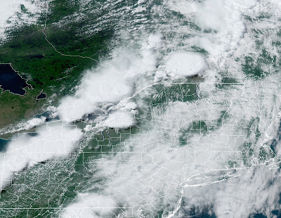
Those big blobs you see in this satellite photo near 
western and northern New York and over Montreal are
intense late afternoon thunderstorms Thursday.
They rapidly weakened later as they moved into Vermont.
 From a weather geek's perspective, anyway, it was fascinating to watch how relatively stable air over Vermont chewed up, destroyed and spit out what had been some powerful thunderstorms approaching from the west and north Thursday evening. 

There had been a tornado watch out for all but eastern New York. It felt like tornado weather here in Vermont too, as winds became strong and gusty from the south, seemingly feeding  into the line of storms and supercells over the St. Lawrence River Valley and near Montreal.

The storms caused flooding and wind damage around Montreal.  Many trees and power lines came down in northwestern and far northern New York, too. 

Radar showed one severe storm managed to make it all the way into far northwestern Vermont  before dying out as it approached Jay Peak.  That storm pounded Highgate with hail at least the size of quarter, and cars there are reportedly dented.  

Just a little to the south and east was me, in St. Albans. The approaching storm looked menacing, a solid line of black to my west in New York State.  By the time the storm was overhead, though, it was just a gentle thundershower. I saw a few cloud to cloud lightning strokes. Winds gusted to about 30 mph under the storm, which was actually calmer than the winds in the hours leading up to the storm. Rainfall was moderate. 

By the time the storms reached Burlington, they could only muster 0.04 inches of rain. 

Another couple of cold fronts are coming through today. They'll set off more showers and storms.  Almost everybody will have at least a sprinkle. The showers were passing through northwestern Vermont this morning. 

Storms looked ominous on approach to St. Albans, 
Vermont Thursday evening, but were rather gentle
by the time they rolled into town. 

A few lucky devils might see some gusty winds and small hail, especially east of the Green Mountains. That's because there will be a few hours of heating before the showers get there. The sun's heat will help destabilize the air, giving a little extra energy to the showers and storms. 

Then "winter" arrives.

COLD WAVE TO IMPRESS

After seasonable temperatures in the 70s to around 80, the second cold front comes through this evening, and that one will mean business. 

Temperatures will crash this evening and overnight to the 40s to around 50 by dawn. That's not so bad, but then readings won't go up much tomorrow.

Saturday's weather is actually a classic winter upslope snow event. In those winter situations, cold northwest winds go up and over the Green Mountains dumping half a foot or a foot of snow on the mountains. The snow showers often back up into the Champlain Valley, so a couple to a few inches of snow pile up there, too.

But it's June. It's pretty hard to get snow near the Summer Solstice. That said, it's still looking cold enough for some wet snow flakes Saturday morning at the summits of the Adirondacks and northern Green Mountains. That's pretty unusual for late June. 

The chill tomorrow is also impressive.  Light rain now expected most of the day in the Champlain Valley will keep things particularly chilly. The record for lowest high temperature for Saturday is 56 degrees, and that might well be challenged.

Some colder spots in mid to high elevations and in the Northeast Kingdom might not get out of the 40s Saturday afternoon. Brisk north winds will make things feel even colder.

Though the coldest hollows might get into the 30s at night during this cold snap, it's good to know it won't get quite nippy enough to produce late season frost. 

The strong upper level low causing this summer chill is looking like it will move out more slowly than earlier forecasts indicated. So Sunday is looking a little cloudier, and a little colder than first forecast. Western Vermont could see highs topping 60 degrees Sunday, while eastern Vermont, especially north of White River Junction stays in the 50s. 

That's still very, very cold for June.

We're still looking at a slow warmup to seasonable weather once again by midweek, so summer ain't over, despite this weekend's very autumnal chill.

Thursday, March 3, 2022

A Blast Of Winter, Then A Messy Warmup

The warm March sun melted a light coating of snow off
my St. Albans, Vermont driveway yesterday. No such 
luck today. We got another inch of snow, but it's 
much, much colder than Wednesday.
 In some ways, it felt like the movie "Groundhog Day" this morning.

Most of us in woke up this morning to one or two inches of snow, just like we did yesterday. Areas right in the immediate Champlain Valley like around Burlington, barely managed a dusting both mornings.  

Today will play out a lot differently than yesterday, though. 

True, the sun is coming out, just like it did Wednesday.  But we're not going to have the benefit of that strengthening March sun to melt away the flurries like we did yesterday. Instead we're getting what might be the last good blast of winter cold of the season.

Temperatures this morning are crashing behind a cold front, and nobody will make it into the 30s like yesterday. Northern areas were in the 20s before dawn and were already in the teens by 8 a.m. Those areas will stay in the teens all day, which is a good 20 degrees colder than normal.

For a lot of us, tomorrow morning might well be the last subzero weather we'll have until next winter. No guarantees, as we can get subzero weather all the way to late March, but the chances of below zero weather after tomorrow are rapidly decreasing.  

Except in the usual cold hollows, where it will probably go below zero again later this month. Sorry, Island Pond and Saranac Lake! 

We'll still have wintry cold spells through this month and into April, but they will be diminishing in intensity. 

It will still be cold but for the season Friday and most of Saturday, but quiet. But then things change, as they always do in March.

Two storms have our eyes on us here in Vermont. I don't think either will be a blockbuster, but they'll still screw around with things a bit. 

The first one will crank up in the central Plains and move into the Great Lakes Saturday and Saturday night, then well to our north Sunday. 

It's interesting that NOAA's Severe Storm Center has been bullish on a severe storm and possible tornado outbreak in Iowa with this on Saturday.  That would be pretty far north for such weather this early in the season. And it comes just a few months after a tornado outbreak last December 15 that broke records for tornadoes that far north.

The storm will obviously not create any tornadoes for us here in Vermont, but it will come with its own, somewhat more mundane hazards. 

The storm will fling a warm front at us Saturday night, which will collide with lingering cold air over us. That means a bout of freezing rain and sleet Saturday night and early Sunday which would of course mess up the road conditions.

The good news is it will rapidly warm up on Sunday, changing everything to plain rain. Temperatures in some Vermont towns could reach the low 50s.

It doesn't look like this system will produce nearly enough rain to produce flooding. It could jiggle the remaining ice around on area rivers, which might cause a few problems with ice jams. 

Hot on the first system's heels, Storm Number 2 comes in around Tuesday.  It's unclear so far what this one is going to do, as it looks like it will go right over us or just to our south. 

That would mean we'd get a slug of snow and/or mixed precipitation.  It's too soon to tell how Tuesday's storm will affect us, so we'll just monitor it for now. 

The relatively chilly air coming in behind Tuesday's storm won't have nearly the oomph of what's coming in today, so the cold during the middle of next week won't be dastardly.  Instead, it will be just something we expect in March.  

Friday, February 11, 2022

Untrustworthy "Winter Lite" Has Arrived For An Extended Stay

Some of the snow from the storm a week ago is beginning
to melt now in slightly thaw-ish conditions as we 
enter a sub-season I like to call Winter Lite
 Right on schedule we in Vermont are emerging from the cold depths of winter into what I regard as Winter Lite. 

That's the time of year, usually between about now and around mid-March, when we start entering the joys of mud season.   

During "Winter Lite," we still get nasty subzero cold waves and snowstorms like we do in January, but these spells are interrupted by milder periods, or at least very changeable weather. 

Winter Lite is a tired version of winter. It is sometimes tasteless and annoying, like an ancient can of Bud Lite. It can pack an unpleasant, sickening punch, like Jagermeister. 

Winter Lite is unreliable.  Some years, like 2015, Winter Lite is not much different than the frigid lashes January sends us.  Other years, like 2017, they bring us full-on spring in February, only to surprise us with a huge March blizzard just when we thought we were out of the winter woods.

It's hard to tell for sure, but this year's version of Winter Lite is setting up to be somewhere between those two extremes. The early shot of spring-ish weather was evident yesterday. Burlington had its first day that stayed entirely above freezing for the full 24 hours since December 17.

The mild-ish weather will persist today and tonight.  It'll be above freezing for most of us now through Saturday morning. But not that far above freezing.   The warmest spots will top out in the low 40s.

You'll wake up early Saturday morning to a spring like dawn, with thawing continuing, birds chirping and maybe the scent of skunk coming out of hibernation. Lovely.

Then the cold front arrives to plunge us back to reality. By sunset Saturday, what had been spring will be the harsh reality of winter.  Subzero nights will persist through early Tuesday morning, and daytime highs will get into the teens if we're lucky.

Then we get bounced again to at least a brief thaw and a lot of uncertainty. By Thursday or so, we're at risk of getting either a warm rainstorm with snowmelt, ice jams and possible floods, or another decent sized snowstorm.

Right now odds slightly favor the rainy outcome, but there's no guarantees. There never is in Winter Lite.

Here's another sign we're at that change of seasons.  The risk of severe weather and tornadoes often begins to ramp up a little in the Deep South once we get well into February.  Signs point to at least some severe weather down there toward the middle of next week. 


Saturday, January 22, 2022

This Vermont Morning Even Colder Than Yesterday, Except On "Tropical" Mountain Summits

A waning moon at dawn with a clear sky and temperatures
UPDat around 15 below this morning in St. Albans, Vermont. 
UPDATE: 5 p.m. SATURDAY

Turns out the coldest temperature reported in Vermont this morning was 35 below in Island Pond.

I did already mention the report of 33 below in that Northeast Kingdom town, but it ended up getting a couple degrees colder. 

Judging from the list of low temperatures from this morning provided by the National Weather Service in South Burlington, most of us were in the upper teens to mid 20s below zero. 

It was a bracing morning, for sure! 

Since temperatures were so low, they had nowhere to go but up.

Dramatically, really. Island Pond was up to 19 degrees at 2 p.m. a rise of 54 degree in just seven hours or so. 

We still have more cold weather to go through over the next week. Temperatures will yo-yo all over the place, but expect a few more nights of subzero cold between now and next weekend.

PREVIOUS DISCUSSION

It was another brutally cold morning in and near Vermont as we started Saturday, as you surely am aware.   There were signs of at least some brief relief from the Arctic conditions uphill. I'll get into that in a moment. 

Yesterday and today might end up being the coldest weather of this winter. Though the jury is still out on how intense a cold wave next week will end up being.  Most of Vermont was even colder this morning than on Friday. 

I saw a report of 33 below from Island Pond, Vermont this morning, the first time this winter I've seen that's it's gotten to 30 below in the Green Mountain State. Such readings in the cold hollows used to be fairly common, but now, not so much.

In much of the 20th century and in earlier decades, it used to get into the 40s below zero once every several years in Vermont. The coldest on record for the state is 50 below in 1933.  I don't remember the last time it was 40 below in Vermont. I doubt it will happen this winter. 

In the bigger Vermont towns as of 7 a.m. it was 14 below in Burlington, which is so far two degrees colder than it was yesterday.  Montpelier was 18 below this morning, compared to minus 14 on Friday. Morrisville was at 27 below, a full seven degrees chillier than Friday. Newport reported minus 23.

A couple places actually managed to be "warmer" this morning than on Friday.  Highgate was 17 below early this morning, compared to 20 below Friday. 

The teens below zero were more widespread this morning that yesterday. Far southern Vermont was in the single numbers below zero yesterday. This morning, I'm noticing 11 below in Bennington and 17 below in Springfield.

Northern New York, like yesterday, wins the prize for coldest in the region. It was 30 below for the second day in a row in Saranac Lake. Ogdensburg was once again at 33 below. Brrr!!  It was also in the 30s below at several locations in northern Maine. The coldest I've seen so far this morning in Maine is 35 below. 

The National Weather Service office in South Burlington will later this morning surely have a comprehensive list of Vermont low temperatures, and I can pass those along when they're available and if they yield anything interesting. 

The "warm" spots this morning are actually in the reporting stations that are normally the most frigid - the mountain summits. Most of those places were actually above zero early today. Even Mount Washington, New Hampshire was at 1 above zero. While Vermont's valleys were still solidly in the teens and 20s below zero at 8 a.m., the top of Mount Mansfield was a toasty 5 above zero.

Those warm summits are a sign that this Arctic blast is all but finished.  Cold air over us drained into the valleys, which is why this Saturday morning is so cold for most of us.  Meanwhile, warmer air started moving in aloft, which is why the summits are so warm. Comparatively speaking anyway.

The weak winter sun later this morning will be enough to mix the atmosphere and most of us will quickly warm into the teens this afternoon. That's still colder than normal, but still better than yesterday!

The mild spell will be short-lived as another Arctic cold front Sunday will drive us back below zero by Monday morning. This one will be brief and not as cold as Friday and this morning were. But another Arctic front expected Tuesday will open the doors for another spell of icebox weather for the second half of next week that could rival the weather we've just been through.

I still see signs of something of a pattern change that would make us a little milder. It might not be super warm, but better.  This new pattern, if it develops, would also probably be more active, which would be a switch from the mostly very dry weather we've seen this month. 

Though nothing is sure on this yet, the chances of snow or other types of precipitation seem like they'll go up as we get into February. 

Thursday, January 13, 2022

Vermont Thursday Evening Update: Arctic Blast On Its Way; Storm Questions Remain

The National Weather Service in South Burlington put out
a map with expected wind chills Friday night and 
Saturday. Click on the map to make it bigger and easier
to see. Widespread 30s and 40s below wind chills expected.
 It's been kind of an interesting meteorological day in Vermont, amid the fog and gloom of January. 

A weather front was draped over the northern end of the state.  Near the Canadian border, temperatures stayed stuck near 20 degrees all day.   Along and south of Route 2, temperatures reached the 30s. 

Tonight, that front will consolidate and move south, first giving us some patchy light snow. Then, later on, it will start to bring us that long heralded cold blast will arrive. It should be near or below zero by the time the sun sets Friday. 

The wind will really pick up from the north, gusting to at least 30 mph Friday afternoon and night. Wind funneling down the Champlain Valley might produce some higher gusts. 

Needless to say with the subzero temperatures and strong gusts driving wind have prompted a wind chill warning for pretty much all of Vermont. Wind chills Friday night into Saturday will be in the 30 to 45 below range. That's the worst I've seen in years. 

We're lucky the offshore storm that will contribute to Friday and Friday night's wind won't be closer.  We'd really get into the gales. As it is, they're expected gusts to 70 mph on Cape Cod and the Islands with this thing. 

As we mentioned, it'll stay quiet and cold over the weekend before the storm arrives.

We're at the stage at which the computerized forecasting models are "windshield wipering," as I like to say.  We've pretty much established that a storm will be going up the East Coast, but the exact path is still very much in doubt.

The computer models go back and forth like windshield wipers with the storm track.  It's going east of New England!, Wait, no, it's going up through Central New England! Ooops, no, further east!  Wait, up through New York?  

Experienced meteorologists tend to ignore individual model runs, and watch for trends. The atmosphere is all connected, so experts are watching the atmosphere from the West Coast of North America all the way to off the East Coast right now.  That will help meteorologists refine the expected storm track as we get closer to the event. 

Once we get closer to the storm, meteorologists will start making stabs at predicting how much snow we'll get out of this. Wisely, nobody is hazarding a guess quite yet. 

Another thing that's still being watched: There could be localized strong or damaging winds with this, especially along the western slopes of the Green Mountains and parts of the Northeast Kingdom. We'll see!

There's now no question, though, that this will be a disruptive storm for somebody. Before the storm makes the turn north, it looks like a stripe of the South from Arkansas to Georgia and the Carolinas are in for some rough winter weather Saturday and Sunday. We're talking snow, and worse, freezing rain and sleet. Nobody handles ice all that well, but southerners are especially bad at it. 

So, like every storm risk, we'll just wait for updates and pass 'em along.  Stay warm, everyone! 


Monday, January 10, 2022

Bitter Cold Through Tuesday Night. How To Manage The Deep Freeze

I'm sure many of us Vermonters will relate
to this meme over the next few days. 
  The frigid air is arriving here in Vermont, so we might as well hunker down and deal with the deep freeze.  
 

The first wave of cold air came through a little after midnight, and as dawn breaks, temperatures across most of Vermont are in the teens.

That's not bad by our standards, but as we know, it will get worse. Temperatures will stay steady or slowly fall during the day today, then start to get ridiculous tonight. 

By ridiculous, I mean it will be down to levels we're not used to.  But this won't be anywhere close to a record breaker.  Record lows this time of year are well down in the 20s below zero, and it won't get that cold. At least if you don't factor in the expected wind chill. 

This will be a nasty one, though, as winds continue to blow from the northwest through tonight and tomorrow. 

Vermont's "banana belts" - the Champlain Valley and valleys of southern Vermont, are under wind chill advisories with expected "real feel" temperatures in the minus 20s.  For the rest of northern Vermont, you're under a somewhat more dire wind chill warning tonight and tomorrow, as it's expected to feel like its in the minus 30s in those spots. 

Actual temperatures will get into the upper single numbers and teens below zero for most of us by Tuesday morning.  Tuesday afternoon will "warm"  all the way up to about zero.  I'm not impressed.

It'll be cold again Tuesday night, but in areas west of the Green Mountains, it might actually start to warm up in the wee hours before dawn Wednesday as the coldest core of the bitter air passes off to the northeast.

Wednesday morning will be one of those famous Vermont "warming up frigid" periods. By that I mean temperatures will be slowly rising through the single numbers and teens, but at the same time strong south winds will increase, especially in the Champlain Valley. So wind chills will remain a factor even as temperatures rise.

To refresh your memory on what to do when we get these bitter cold periods, here's a couple tips. For starters, go down right now to the gas station and totally fill up your car's gas tank.  The vehicle will start better in the morning that way.

The full gas tank is a great idea because it always seems you get stuck or slide off the road at the worst possible time, when its frigid. You'll need a full tank of gas to keep the engine running and the heat on if you have to wait.

Don't make the mistake of not dressing for the weather if you're thinking, "Ah, I'm just going from the house, to the car, then getting right out at my destination." That thinking means you might not have warm enough clothes if you unexpectedly have to stay outside for any length of time. 

Even having to deal with a dreaded fender bender will take you outside for awhile, and you want to be ready for it. Also, throw a warm blanket into the car to use, just in case. Bring snacks, too, while you're at it. Protein bars are fine for an emergency.

The reason I'm harping on this is because my past experience with cold snaps is there's always crashes and big long traffic tie ups, especially along places like Interstate 89.  

Bridges tend to have thin sheets of ice on the pavement.  Especially if the bridge is over streams or rivers.  Steam rising from the water in the cold air freezes to the pavement and you end up with black ice. Speed demons who don't know how to drive love to cause problems with these icy patches.

It seems that Every Single Time we get a below zero spell, there's a crash on the Interstate 89 bridges over the Winooski River between the Colchester and Burlington exits.  Those bridges freeze, cars collide, and everybody else then has to sit behind the wreck in stalled traffic all the way to Milton. 

Lake effect snow will also deposit light accumulations of snow in the southern half of the Champlain Valley and in the central Green Mountains during this, too. So there will be issues with slick roads there, too. 

Although it will warm up by Wednesday afternoon, relatively speaking, we still will remain on the chilly side at least through Sunday. 

We might actually make it to near normal temperatures on Thursday (Highs 25-32) before it gets cold again after that.  The next cold snap, Friday through Sunday, won't be as nasty as the one we're about to enter tonight.  But still, we'll have some more subzero temperatures to deal with then.

At this point, forecasters think the cold high pressure feeding that chilly air into Vermont next weekend will keep storminess and snow south and east of us.  However, that's really an uncertain forecast, so we'll have to watch and see what happens.  

Wednesday, April 21, 2021

A Wild Daffodil Destroyer Storm Today/Tonight Northern New York/Northern New England

Green grass and an abundance of daffodils surrounded my
garden shed in St. Albans, Vermont Tuesday. Incoming
daffodil-destroying storm will unfortunately 
change this scene for the worse over the next 24 hours.
I picked some daffodils from my gardens in St. Albans, Vermont last evening for an indoor flower arrangement. 

I did so because I suspect the dozens and dozens of daffodils blooming outside my house will be dead by tomorrow morning, I'm afraid.  

A daffodil destroying winter storm is set to pounce. 

Here in Vermont, we can expect some accumulating snow today and tonight, accompanied by a harsh freeze overnight and Thursday morning. Light snow had already started here in St. Albans as of 6 a.m. 

So much for spring. 

I'll get more into Vermont's wintry outlook in just a bit. But I have to say how chillingly impressed I am by the wintry weather extending across most of the nation east of the Rockies. The early spring this area has had so far has come to a screeching halt. 

 A swath of snow yesterday extended from Oklahoma through the Midwest and Mid-South.  Kansas City, Missouri collected 3.5 inches of snow Tuesday. Flurries dusted parts of Oklahoma. Paducah, Kentucky and Evansville, Indiana had their latest snowfalls on record Tuesday, though there might have been earlier snows before records started being kept there in the 1930s.

Freeze warnings continue to extend across a vast part of the country from most of the southern and central Plains all the way east to places like North Carolina and New Jersey. Snow will continue in parts of the Midwest, New York, northern New England and a good chunk of Ontario and Quebec. 

The dynamic storm and cold front are causing quite a contrast in conditions in the Northeast today. While northern and western Vermont and northern New York deal with snow, temperatures ahead of the storm's cold front will climb to near 70 in southeastern New England. 

The strength of the storm and this temperature contrast will help trigger some severe thunderstorms this afternoon from coastal Virginia to western Massachusetts.  A marginal risk of severe storms even extends as far north as the southern third of Vermont and the southern half of New Hampshire.  

VERMONT IMPACTS

As noted, rain and snow had already developed across much of Vermont and eastern New York early this morning. Winter weather advisories (sigh) are up for much of northern New York and northern Vermont north of Route 15 and away from Lake Champlain. 

However, many parts of Vermont outside the winter weather advisory will see accumulating, flower stomping snow and cold with this storm.  

The dreaded National Weather Service/South Burlington
snow forecast map is back today. Areas in dark blue
can expect at least three inches of new snow by
tomorrow. Yellow areas should see more like
six inches or more.

It'll snow most of the day in the Adirondacks.  In Vermont, it will be warm enough for a mix of rain and snow for this morning,  with all rain of course in southern parts of the state.

This afternoon and evening, the storm's powerful cold front will come in with a burst of heavier snow, especially in northern Vermont. 

It'll likely snow hard enough, even in the Champlain Valley, to perhaps mess with the roads for your late afternoon and evening commute.

If you already took your snow tires off, it sucks for you. Be careful on those roads later today and tonight. 

It looks like one to four inches of snow will accumulate in northern and central Vermont valleys through tonight.  This includes the Champlain Valley, especially north of Burlington. 

Places in the winter weather advisory in Vermont can expect three to six inches of new snow, says the National Weather Service in South Burlington. 

Higher mountains, where last Friday's snow hasn't entirely melted yet, can easily expect six inches to perhaps a foot of new snow through Thursday, especially along the peaks from about Killington north.

Temperatures by Thursday morning will be between 25 and 30 degrees with the snow and strong winds.  A few places will be even colder than that. 

It'll be interesting to see what early outdoor plants survive and which won't. The snow will crush the daffodils, no doubt, which is why I'm calling this storm the destroyer.  A few might survive, so I'll just have to assess, at least in my yard, once it warms up.

Lilacs, with flowers already budding, might not survive either in the anticipated cold, which is really sad. Brilliant white blooming magnolia trees will be a brown mess by tomorrow. 

In most of the area, apple trees in and around Vermont are budding, but mostly not yet blooming, so the apple crop might just hang in there, fingers crossed. Will the early green leaves on some trees survive, or just turn to black, wilted wreckage?  I guess we'll find out tomorrow. 

The snow will go over to snow showers later tonight, and continue all day Thursday under harsh northwest winds.  Temperatures will stay under 40 degrees in most valleys with winds gusting to 35 mph, so wind chills will be an issue. 

With lighter snow showers, possibly mixed with rain drops, valleys won't see any additional snow accumulation to speak of.  Northern mountains will be in the snow all day and will keep piling it up. 

At least the cold snap won't last all that long.  It'll be cold, but not quite as cold Thursday night and Friday morning, so I don't anticipate additional damage to spring greenery.  Friday will be blustery, but at least we have a shot at breaking 50 degrees in the afternoon.

Saturday actually looks pleasant before the next storm comes along Sunday.  Earlier this week, I had feared a cold shot Sunday night and Monday even worse than the one that's just starting.

Happily, I was wrong! It does look damp and rainy and chilly Sunday, but it won't snow.  It'll be cooler than normal Sunday night and Monday, but nothing horrific, with either a very light freeze or more likely no freeze at all at night. 

Signs point to warmer weather next week.  Not only for us, but most of the rest of the shivering nation as well. 

Wednesday, March 31, 2021

Wednesday Evening Update: Snow/Winter Blast Still On For April Fool's Day

 Here in Vermont, we had another warm spring day with temperatures this afternoon within a few degrees of 60.  

As I write this at 6 p.m. Wednesday, spring is just about now going to come to a crashing halt, at least for now.

The strong cold front that is part of the reason why much of Vermont and surrounding areas are in for an April Fool's Day snow was just coming into the Champlain Valley. 

That's a bit faster than projected, and it means it's going to stall out a little further to the east than forecasters thought this morning.

I'm not sure that's going to mean much of a difference in the forecast with this snow, other than to start it a little earlier than projected in some areas.  But some of the deepest moisture might be a little more to the east, or if not that, the atmosphere west could dry out a bit sooner. 

I'm guessing the bottom line is northern New York and northwestern Vermont will still get the same amount of snow as originally predicted - four to nine inches by the time it's all said and done.  East of the northern Greens, there might be a couple more inches more than expected, maybe in the two to six inch range?

Southeastern Vermont is still expected to get very little snow. 

The main storm is still expected to ride north along this front overnight and tomorrow. That puts us on the cold side of the storm. 

The rain with the cold front is mostly behind it. From my office window looking west toward the Adirondacks as of 6 p.m., I can now see the rain blurring away the mountains as the front pushes in.

It will abruptly turn colder behind the front. You'll feel it this evening as temperatures go immediately down into the 40s when the cold front comes through your location. . After that abrupt cooling, temperatures will ever so slowly fall from the low 40s through the 30s until it's cold enough to snow. 

That'll almost certainly be a few hours before dawn in New York State, and probably at or a little before sunrise across northwest Vermont. 

Especially for those west of the Green Mountains and roughly north of Route 4, you might be in for an unpleasant commuting surprise. When you get up in the morning, it could still be raining where you are, but change the snow before you get in the car. 

Or, you'll travel west toward your destination and hit a quick changeover to wet snow.

This snow is part of a sharp, but brief cold wave affecting the eastern United States. A few record lows are possible in the Southeast, but these won't be the coldest temperatures on record for this time of year 

The problem is one we are increasingly having in a climate change spring season. It's been unusually warm for the most part over the past month so fruit trees and other crops in much of the South are way ahead of schedule. They're blooming and starting to set fruit in some cases.

This cold snap and freeze could cause some widespread and expensive agricultural losses.  We've had this type of situation frequently over the past decade, most notably in 2012 and 2017.

We're not as far along up with spring up here in Vermont, but still way ahead of schedule. It will be interesting, and perhaps sad, to see whether any early buds get nipped by this. 

The snow won't hurt them, but overnight temperatures in the upper teens to around 20 degrees Thursday and Friday nights could have an impact. 

We're still expecting a warmup starting Saturday and continuing into next week.